94L Invest Comments Thread #2
Moderator: S2k Moderators
Forum rules

The posts in this forum are NOT official forecasts and should not be used as such. They are just the opinion of the poster and may or may not be backed by sound meteorological data. They are NOT endorsed by any professional institution or STORM2K. For official information, please refer to products from the National Hurricane Center and National Weather Service.


-
Weatherfreak000
Based on my thoughts of Satellite and the fact we have southernly flow I think the system will stay offshore and head into Central Louisiana, TS or not.
But interesting to add I think the movement of the system right now is the best it can be. The GOM has high pressures everywhere and the only thing that is gonna aid that is time. Pressures around Louisiana have been dropped since this morning. I think 94 is moving into the best possible environment for development RIGHT NOW.
But interesting to add I think the movement of the system right now is the best it can be. The GOM has high pressures everywhere and the only thing that is gonna aid that is time. Pressures around Louisiana have been dropped since this morning. I think 94 is moving into the best possible environment for development RIGHT NOW.
Last edited by Weatherfreak000 on Sun Jul 02, 2006 1:17 pm, edited 1 time in total.
0 likes
-
Stratosphere747
- Category 5

- Posts: 3772
- Joined: Thu Sep 11, 2003 8:34 pm
- Location: Surfside Beach/Freeport Tx
- Contact:


-
Extremeweatherguy

- Category 5
- Posts: 11095
- Joined: Mon Oct 10, 2005 8:13 pm
- Location: Florida
I don't think it will get that far east (though I wish it could to help out with the drought in that area). Right now I think this will have a landfall somewhere between Corpus Christi and the TX/LA border.Weatherfreak000 wrote:Based on my thoughts of Satellite and the fact we have southernly flow I think the system will stay offshore and head into Central Louisiana, TS or not.
But interesting to add I think the movement of the system right now is the best it can be. The GOM has high pressures everywhere and the only thing that is gonna aid that is time. Pressures around Louisiana have been dropped since this morning. I think 94 is moving into the best possible environment for development RIGHT NOW.
0 likes
-
Air Force Met
- Military Met

- Posts: 4372
- Age: 57
- Joined: Tue Jul 08, 2003 9:30 am
- Location: Roan Mountain, TN
Stratosphere747 wrote:While your here AFM maybe you can help with question I had earlier.
How much impact does the ULL out in West Texas have on whatever this mess is, and the movement? Is it possible that the northerly movement would slow down if the ULL retrogrades more to the west?
I think the ULL will keep it moving N...and enhance the heck out of it...but the overall spead should stay the same. The more it retrogrades though...the more diffluence that sets up at the jet level...but the less mid level energy and the further west the max precip will be. Right now...my guess for max precip is Matagorda-Brazoria county and northward...with some areas of 12-15" over the next 3 days....maybe an isolatd 18".
0 likes
-
southerngale

- Retired Staff

- Posts: 27418
- Joined: Thu Oct 10, 2002 1:27 am
- Location: Southeast Texas (Beaumont area)
Air Force Met wrote:Stratosphere747 wrote:While your here AFM maybe you can help with question I had earlier.
How much impact does the ULL out in West Texas have on whatever this mess is, and the movement? Is it possible that the northerly movement would slow down if the ULL retrogrades more to the west?
I think the ULL will keep it moving N...and enhance the heck out of it...but the overall spead should stay the same. The more it retrogrades though...the more diffluence that sets up at the jet level...but the less mid level energy and the further west the max precip will be. Right now...my guess for max precip is Matagorda-Brazoria county and northward...with some areas of 12-15" over the next 3 days....maybe an isolatd 18".
Geezaloo! That's like it was here a couple of weeks ago. Nobody needs that!
According to NWS, our heavy rain chances are very high for several days, but so far, just some scattered showers, so crossing my fingers that there's no more flooding here, or anywhere for that matter.
0 likes
-
Weatherfreak000
Extremeweatherguy wrote:I don't think it will get that far east (though I wish it could to help out with the drought in that area). Right now I think this will have a landfall somewhere between Corpus Christi and the TX/LA border.Weatherfreak000 wrote:Based on my thoughts of Satellite and the fact we have southernly flow I think the system will stay offshore and head into Central Louisiana, TS or not.
But interesting to add I think the movement of the system right now is the best it can be. The GOM has high pressures everywhere and the only thing that is gonna aid that is time. Pressures around Louisiana have been dropped since this morning. I think 94 is moving into the best possible environment for development RIGHT NOW.
Extreme, look:
http://www.ssd.noaa.gov/goes/east/gmex/loop-avn.html
You see how the thunderstorms ahead of the main blob have been moving? That's the steering currents that are going to push all that moisture into Louisiana. It's allready very evident to me.
I have no doubt the Texas border will probably catch the tail end of this action, but the system I think is likely to move into Louisiana.
0 likes
-
mvtrucking

- S2K Supporter

- Posts: 698
- Age: 67
- Joined: Sat Jul 09, 2005 10:01 am
- Location: Monroe,La
Extremeweatherguy wrote:well if no one likes my posting JB's thoughts then may be I will just stop doing so. Basically, his tone and post suggested a decent shot (25%+ is what I consider decent) of something developing. He also went on to mention 35mph gusts being reported, and a possible Allison or Dean like scenario and the GFS showing deepening. To me, this all went on to say that he is thinking there is a decent shot at development. REMEMBER: decent does not mean definite.
What I am trying to do is condense JB's long posts into brief summarized accounts, and I think by saying he thinks the system has a "decent" shot is within the range of what is acceptable. If you want his EXACT words (un-summarized), then please feel free to become a member of Accuweather.com professional and interpret his posts for yourself.
I appreciate your posts concerning JB. Your interpretation of JB's comment's was fine with me. Please continue to post JB's outlooks, as I'm sure they are appreciated by many.
Last edited by mvtrucking on Sun Jul 02, 2006 1:28 pm, edited 1 time in total.
0 likes
-
Stratosphere747
- Category 5
- Posts: 3772
- Joined: Thu Sep 11, 2003 8:34 pm
- Location: Surfside Beach/Freeport Tx
- Contact:
-
southerngale
- Retired Staff
- Posts: 27418
- Joined: Thu Oct 10, 2002 1:27 am
- Location: Southeast Texas (Beaumont area)
Weatherfreak000,
According to everything I've read from the officials, Western Louisiana should also get quite a bit of rain tomorrow and the 4th of July, but I haven't found where any officials are saying that Louisiana will get the brunt of it instead of Texas. I do hope the areas of Louisiana that need rainfall get it though and the areas of Texas who don't need it, don't get too much (like here).
According to everything I've read from the officials, Western Louisiana should also get quite a bit of rain tomorrow and the 4th of July, but I haven't found where any officials are saying that Louisiana will get the brunt of it instead of Texas. I do hope the areas of Louisiana that need rainfall get it though and the areas of Texas who don't need it, don't get too much (like here).
0 likes
-
Extremeweatherguy
- Category 5
- Posts: 11095
- Joined: Mon Oct 10, 2005 8:13 pm
- Location: Florida
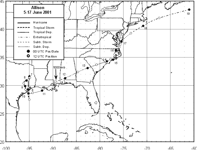
I was thinking that this may be too close to significantly develop into a TS, but then I realized that Allison formed in a similar place. This system may actually have more room right now than Allison did:
http://www.nhc.noaa.gov/prelims/2001allison1.gif
Also, I realized that just because it looks bad on radar, that doesn't mean it can't become a TS. Look at how poor Allison looked at landfall:
http://www.srh.noaa.gov/hgx/projects/al ... ooding.gif
http://www.nhc.noaa.gov/prelims/2001allison1.gif
Also, I realized that just because it looks bad on radar, that doesn't mean it can't become a TS. Look at how poor Allison looked at landfall:
http://www.srh.noaa.gov/hgx/projects/al ... ooding.gif
0 likes

Air Force Met wrote:Extremeweatherguy wrote:well if no one likes my posting JB's thoughts then may be I will just stop doing so. Basically, his tone and post suggested a decent shot (25%+ is what I consider decent) of something developing. He also went on to mention 35mph gusts being reported, and a possible Allison or Dean like scenario and the GFS showing deepening. To me, this all went on to say that he is thinking there is a decent shot at development. REMEMBER: decent does not mean definite.
What I am trying to do is condense JB's long posts into brief summarized accounts, and I think by saying he thinks the system has a "decent" shot is within the range of what is acceptable. If you want his EXACT words (un-summarized), then please feel free to become a member of Accuweather.com professional and interpret his posts for yourself.
I am a member...that is why I know that he didn't say that. He said that with the mischief you can get along the Texas coast you can get a system that is open to the west but still have TS winds to the east....and that is his fear. Having a fear does not mean a decent shot....its just a fear....or in JB termonology...something that has him interested because of things that have happened in the past.
I am not saying don't summerize...but what I am saying is don't put words in his mouth. You could just as easily said JB has a fear of this thing turning into a TS Dean-like system...open on the west and TS force winds on the east...and that would have been a 100% accurate statement.
Maybe it doesn't mean much to amatuers...but to Pro-Mets...the term "decent chance" is a term we use when making forecasts...and when we use that term...or terms like it (not the term fear...etc)...we are basically sticking our neck out and saying "I think it will..."
Hope that helps.
Thanks AFM for your input to my previous post about what JB said/did not say. I am also a member. My post was just to make sure what JB said was in fact correct so as to not alarm any one one into thinking there was a tropical system developing off the Texas coast as was being posted. Thanks for clearing things up. No hard feelings toward EWG, just wanted to set the record straight. As my father used to say,"It's not what you say, it is how you say it". Thanks again AFM.
Robert
0 likes
-
Extremeweatherguy
- Category 5
- Posts: 11095
- Joined: Mon Oct 10, 2005 8:13 pm
- Location: Florida
-
Air Force Met
- Military Met
- Posts: 4372
- Age: 57
- Joined: Tue Jul 08, 2003 9:30 am
- Location: Roan Mountain, TN
Extremeweatherguy wrote:I was thinking that this may be too close to significantly develop into a TS, but then I realized that Allison formed in a similar place. This system may actually have more room right now than Allison did:
http://www.nhc.noaa.gov/prelims/2001allison1.gif
Also, I realized that just because it looks bad on radar, that doesn't mean it can't become a TS. Look at how poor Allison looked at landfall:
http://www.srh.noaa.gov/hgx/projects/al ... ooding.gif
ONe thing about Allison though...that is the place where they issued the 1st advisory...that is not where she formed. She had a good circulation LONG before they issued. The TWO from 5am that morning said nothing about Allison...actually said nothing about nothing...just TS formation not expected thru Wed. However, the blob that was Allison already had a well defined circualtion and TS force winds by mid-morning....it just took the NHC that long to recognize it.
Allison was truly one of their worst dropped balls...from the no-mention of her on the TWO at 5am to a TS or 60 mph 12 hours later bearing down on the coast.
0 likes
-
Air Force Met
- Military Met
- Posts: 4372
- Age: 57
- Joined: Tue Jul 08, 2003 9:30 am
- Location: Roan Mountain, TN
mvtrucking wrote:
I appreciate your posts concerning JB. Your interpretation of JB's comment's was fine with me. Please continue to post JB's outlooks, as I'm sure they are appreciated by many.
My problem was that it probably wouldn't have been fine with the author...maybe fine with you...but would it have been fine with him? As a Pro-Met...it wouldn't have been fine with me.
0 likes
-
bigmoney755
-
Pearl River

- S2K Supporter
- Posts: 825
- Age: 67
- Joined: Fri Dec 09, 2005 6:07 pm
- Location: SELa
-
Extremeweatherguy
- Category 5
- Posts: 11095
- Joined: Mon Oct 10, 2005 8:13 pm
- Location: Florida
-
Extremeweatherguy
- Category 5
- Posts: 11095
- Joined: Mon Oct 10, 2005 8:13 pm
- Location: Florida
Who is online
Users browsing this forum: No registered users and 170 guests