ENSO Updates (2007 thru 2023)

This is the general tropical discussion area. Anyone can take their shot at predicting a storms path.

Moderator: S2k Moderators

Forum rules

The posts in this forum are NOT official forecasts and should not be used as such. They are just the opinion of the poster and may or may not be backed by sound meteorological data. They are NOT endorsed by any professional institution or STORM2K. For official information, please refer to products from the National Hurricane Center and National Weather Service.

Help Support Storm2K
Message
Author
User avatar
cycloneye
Admin
Admin
Posts: 145294
Age: 68
Joined: Thu Oct 10, 2002 10:54 am
Location: San Juan, Puerto Rico

#261 Postby cycloneye » Thu Apr 05, 2007 7:16 pm

AussieMark wrote:3 months till La Nina is a bit optimistic since Nino 3.4 has only had negative values for one week and that was like 2-3 weeks ago now.


Here are the numbers from the start of 2007 for El Nino 3-4 area.Still the numbers dont show 3-4 turning cooler.

2007010120070107 0.92
2007010820070114 0.83
2007011520070121 0.57
2007012220070128 0.43
2007012920070204 0.32
2007020520070211 0.20
2007021220070218 0.20
2007021920070225 0.05
2007022620070304 0.08
2007030520070311 0.04
2007031220070318 0.14
2007031920070325 0.12
2007032620070401 0.14

http://www.bom.gov.au/climate/enso/indices.shtml
0 likes   

User avatar
SouthFloridawx
S2K Supporter
S2K Supporter
Posts: 8346
Age: 46
Joined: Tue Jul 26, 2005 1:16 am
Location: Sarasota, FL
Contact:

#262 Postby SouthFloridawx » Sat Apr 07, 2007 1:55 pm

After a brief warming as we are seeing... I think we'll see this regions temperatures fall.

CPC model show's 1 & 2 bombing to -2.0 below normal temps.
http://www.cpc.ncep.noaa.gov/products/a ... SSTMon.gif

Nino 3, not as severe but to -1.5.
http://www.cpc.ncep.noaa.gov/products/a ... SSTMon.gif

Nino 3.4 down to -1.5 Also
http://www.cpc.ncep.noaa.gov/products/a ... SSTMon.gif

Nino 4 to a little below .-5
http://www.cpc.ncep.noaa.gov/products/a ... SSTMon.gif
0 likes   

User avatar
SouthFloridawx
S2K Supporter
S2K Supporter
Posts: 8346
Age: 46
Joined: Tue Jul 26, 2005 1:16 am
Location: Sarasota, FL
Contact:

#263 Postby SouthFloridawx » Sat Apr 07, 2007 2:00 pm

After looking at another link... it does show the SOI drop, but will it continue?

In the CPC model forecast, nino 1+2 and even 3 to 3+4... we see the temps drop to below 1.5.

However in the Nina 4 region, we see it only go to -.5.


Could the SOI only affect the majority of an area? Could it mainly affect the Mean temps in mostly the Nino 4 region? Of course since 3 and 4 are link this is going to cause warming in that region also.

What area affects the Atlantic?

Is it mainly Nino 1 through 3?

Is Nino 4 more of a what is to come Region?
0 likes   

User avatar
wxmann_91
Category 5
Category 5
Posts: 8013
Age: 34
Joined: Fri Jul 15, 2005 2:49 pm
Location: Southern California
Contact:

#264 Postby wxmann_91 » Sat Apr 07, 2007 2:44 pm

The greatest negative subsurface anomalies are over the Nino 1.2 region. It might turn out that this Nina might be similar to the last Nino, in that the Nino 1.2 area has the greatest anomalies, and the resultant midlatitude response is different than what is expected for a "normal" Nina.
0 likes   

User avatar
AussieMark
Category 5
Category 5
Posts: 5858
Joined: Tue Sep 02, 2003 6:36 pm
Location: near Sydney, Australia

#265 Postby AussieMark » Sat Apr 07, 2007 6:57 pm

Nino 4 needs to drop before we can get into La Nina

since a ENSO are based on the Nino 3.4 anomalities

Nino 4 is still very positive
0 likes   

User avatar
gatorcane
S2K Supporter
S2K Supporter
Posts: 23691
Age: 47
Joined: Sun Mar 13, 2005 3:54 pm
Location: Boca Raton, FL

#266 Postby gatorcane » Sat Apr 07, 2007 8:04 pm

Looks very likely we will have a significant La Nina event this year as SSTs are very cool at this moment. That combined with above normal SSTs in the Atlantic is going to make an interesting situation for us.
0 likes   

User avatar
cycloneye
Admin
Admin
Posts: 145294
Age: 68
Joined: Thu Oct 10, 2002 10:54 am
Location: San Juan, Puerto Rico

#267 Postby cycloneye » Mon Apr 09, 2007 5:08 pm

Image

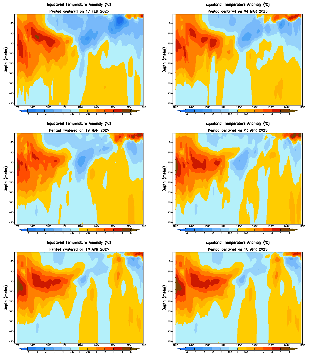
There is a division of the cool and warmer waters.More cooler subsurface waters east of 140w and more warmer waters west of 140w at el nino 3-4.
0 likes   
Visit the Caribbean-Central America Weather Thread where you can find at first post web cams,radars
and observations from Caribbean basin members Click Here

User avatar
cycloneye
Admin
Admin
Posts: 145294
Age: 68
Joined: Thu Oct 10, 2002 10:54 am
Location: San Juan, Puerto Rico

#268 Postby cycloneye » Tue Apr 10, 2007 6:40 pm

It will be very interesting to see what BoM in the next update that will be released in a few hours will say about the SOI continuing to go down.

http://www.bom.gov.au/climate/enso/soi.dt3
0 likes   
Visit the Caribbean-Central America Weather Thread where you can find at first post web cams,radars
and observations from Caribbean basin members Click Here

User avatar
AussieMark
Category 5
Category 5
Posts: 5858
Joined: Tue Sep 02, 2003 6:36 pm
Location: near Sydney, Australia

#269 Postby AussieMark » Wed Apr 11, 2007 5:45 am

BOM have delayed their ENSO summary for 2 weeks

so next one will be out April 25
0 likes   

User avatar
P.K.
Professional-Met
Professional-Met
Posts: 5149
Joined: Thu Sep 23, 2004 5:57 pm
Location: Watford, England
Contact:

#270 Postby P.K. » Wed Apr 11, 2007 6:33 am

Was just wondering why the date had changed on it. :lol:
0 likes   

User avatar
cycloneye
Admin
Admin
Posts: 145294
Age: 68
Joined: Thu Oct 10, 2002 10:54 am
Location: San Juan, Puerto Rico

#271 Postby cycloneye » Wed Apr 11, 2007 6:43 am

AussieMark wrote:BOM have delayed their ENSO summary for 2 weeks

so next one will be out April 25


Maybe,they want to wait for more data from the SOI that is still going down to then make a better forecast.
0 likes   
Visit the Caribbean-Central America Weather Thread where you can find at first post web cams,radars
and observations from Caribbean basin members Click Here

MWatkins
S2K Supporter
S2K Supporter
Posts: 2574
Joined: Sat Oct 12, 2002 7:51 pm
Location: SE Florida
Contact:

#272 Postby MWatkins » Wed Apr 11, 2007 10:26 am

Yeah...the SOI has tanked a little...but I really think too much can be made of an index that is updated daily...it's kind of like watching the wobbles in satellite imagery and calling the wobble movement...

I think this is the index to watch...but it isn't as fun since it is updated weekly.

nino 3.4 has nudged up slightly...but still way down there at .21...

http://www.bom.gov.au/climate/enso/nino_3.4.dt3

MW
0 likes   
Updating on the twitter now: http://www.twitter.com/@watkinstrack

User avatar
P.K.
Professional-Met
Professional-Met
Posts: 5149
Joined: Thu Sep 23, 2004 5:57 pm
Location: Watford, England
Contact:

#273 Postby P.K. » Wed Apr 11, 2007 12:46 pm

3 month Nino 3.4 ave is dropping about 0.06C a week at the moment, that will slow soon though as it is about as cool at the moment as it was two months ago. About time I did a new Nino 3.4 graph really.

I think the late update is due to the mets at the BoM being too busy watching the cricket world cup. :wink: :lol:
0 likes   

User avatar
SouthFloridawx
S2K Supporter
S2K Supporter
Posts: 8346
Age: 46
Joined: Tue Jul 26, 2005 1:16 am
Location: Sarasota, FL
Contact:

#274 Postby SouthFloridawx » Thu Apr 12, 2007 3:52 pm

MWatkins wrote:Yeah...the SOI has tanked a little...but I really think too much can be made of an index that is updated daily...it's kind of like watching the wobbles in satellite imagery and calling the wobble movement...

I think this is the index to watch...but it isn't as fun since it is updated weekly.

nino 3.4 has nudged up slightly...but still way down there at .21...

http://www.bom.gov.au/climate/enso/nino_3.4.dt3

MW


I don't have a program that is able to read that file...

What kind of software do you need?
0 likes   

User avatar
P.K.
Professional-Met
Professional-Met
Posts: 5149
Joined: Thu Sep 23, 2004 5:57 pm
Location: Watford, England
Contact:

#275 Postby P.K. » Thu Apr 12, 2007 3:54 pm

Notepad will do fine, it is only a text file.
0 likes   

User avatar
cycloneye
Admin
Admin
Posts: 145294
Age: 68
Joined: Thu Oct 10, 2002 10:54 am
Location: San Juan, Puerto Rico

#276 Postby cycloneye » Fri Apr 20, 2007 6:51 am

http://iri.columbia.edu/climate/ENSO/cu ... nical.html

This is the April update from IRI independent group that does forecasts of ENSO.They say Neutral to weak la nina will be the rule thru the summer.El nino is not likely to make an appearance.
0 likes   
Visit the Caribbean-Central America Weather Thread where you can find at first post web cams,radars
and observations from Caribbean basin members Click Here

User avatar
SouthFloridawx
S2K Supporter
S2K Supporter
Posts: 8346
Age: 46
Joined: Tue Jul 26, 2005 1:16 am
Location: Sarasota, FL
Contact:

#277 Postby SouthFloridawx » Fri Apr 20, 2007 6:44 pm

Been watching the shear anomaly graphic at the ssd site and it looks like we've got below normal shear already. Not trying to freak anyone, just sharing information that I noticed.

[web]http://www.ssd.noaa.gov/PS/TROP/DATA/gparm/xyashr.gif[/web]

[web]http://www.ssd.noaa.gov/PS/TROP/DATA/gparm/xycshr.gif[/web]

[web]http://www.ssd.noaa.gov/PS/TROP/DATA/gparm/xyrshr.gif[/web]
0 likes   

User avatar
canegrl04
Category 5
Category 5
Posts: 2486
Joined: Thu Aug 26, 2004 5:37 pm
Location: Texas

#278 Postby canegrl04 » Fri Apr 20, 2007 8:42 pm

Below normal shear and warm ssts are a recipe for disaster for the US coastline this season :eek: But we've got a couple more months to go.If the trend continues ,get ready for a 2005 type of hurricane season
0 likes   

MiamiensisWx

#279 Postby MiamiensisWx » Sun Apr 22, 2007 6:32 pm

canegrl04 wrote:Below normal shear and warm ssts are a recipe for disaster for the US coastline this season :eek: But we've got a couple more months to go.If the trend continues ,get ready for a 2005 type of hurricane season

This post seems alarmist. In addition, it only adds to complacency. Seasons with the 2005, 1933, and 1995 levels of activity are exceptional. They are extremely rare. Hyping each season to 2005 levels only results in less respect for seasons with totals below 28 named storms. Andrew (1992) and Alicia (1993) occurred in below average seasons. I can recall many examples of below average seasons with deadly and destructive landfalls. As we have seen in many years, even a tropical storm can kill people.

We need to stop the 2005 (and global warming) hysteria. We do not need panic (and complacency). I'm not worried or nonchalant. Preparation is the key.

On an unrelated side note, I'm starting to believe La Nina may not form, and if it develops I believe it will be a weak event.
0 likes   

User avatar
deltadog03
Professional-Met
Professional-Met
Posts: 3580
Joined: Tue Jul 05, 2005 6:16 pm
Location: Macon, GA

#280 Postby deltadog03 » Sun Apr 22, 2007 7:57 pm

ya the CFS and NCEP model, they might be the same, BLEW the el nino forecast really badly. I seen the Euro's forecast that was updated on april 1 and it has a neutral to a very SLIGHT la nina for the summer and a weak to MDT one for the winter. Now, the CFS has the stuff tanking MUCH earlier so we shall see who gets round 2 right, but round 1 clearly went to the european!
0 likes   


Return to “Talkin' Tropics”

Who is online

Users browsing this forum: Google Adsense [Bot] and 42 guests