Invest 98L in Western Atlantic

This is the general tropical discussion area. Anyone can take their shot at predicting a storms path.

Moderator: S2k Moderators

Forum rules

The posts in this forum are NOT official forecasts and should not be used as such. They are just the opinion of the poster and may or may not be backed by sound meteorological data. They are NOT endorsed by any professional institution or STORM2K. For official information, please refer to products from the National Hurricane Center and National Weather Service.

Help Support Storm2K
Message
Author
User avatar
senorpepr
Military Met/Moderator
Posts: 12542
Age: 43
Joined: Fri Aug 22, 2003 9:22 pm
Location: Mackenbach, Germany
Contact:

Re: Invest 98L in Western Atlantic=TCFA issued

#261 Postby senorpepr » Sun Jul 29, 2007 1:42 pm

Tampa Bay Hurricane wrote:Does a TCFA mean that formation
is much more likely than before?


A TCFA is issued when a certain "score" on the checklist is met. Here is a link to that checklist: http://www.nlmoc.navy.mil/trg/tropical/TCFA_Checklist.htm
0 likes   

User avatar
HURAKAN
Professional-Met
Professional-Met
Posts: 46086
Age: 38
Joined: Thu May 20, 2004 4:34 pm
Location: Key West, FL
Contact:

#262 Postby HURAKAN » Sun Jul 29, 2007 1:51 pm

For our experts, do a loop on 30N 70W, is that a LLC or MLC?

http://wwwghcc.msfc.nasa.gov/GOES/goeseastconus.html
0 likes   

User avatar
vbhoutex
Storm2k Executive
Storm2k Executive
Posts: 29113
Age: 73
Joined: Wed Oct 09, 2002 11:31 pm
Location: Cypress, TX
Contact:

Re: Invest 98L in Western Atlantic

#263 Postby vbhoutex » Sun Jul 29, 2007 1:56 pm

Looks like a mid level mini-vortex to me. Had to watch it for a while to make sure though.
0 likes   

miamicanes177
Category 5
Category 5
Posts: 1131
Joined: Tue Aug 01, 2006 10:53 pm

Re: Invest 98L in Western Atlantic

#264 Postby miamicanes177 » Sun Jul 29, 2007 1:56 pm

Jeff Masters said this morning he thought it would be a tropical depression by tuesday. He has gone back into that post and edited that out as well as a few other things. I've learned you have to read Master's blog as soon as possible and copy and paste what he says due to his editing techniques. Wouldn't it be nice as a forecaster to be able to change your forecast after the fact? You would be right 100% of the time. For Master to gain credibility he should leave his original post as is, and make the edits in red letters. That way it doesn't make him look bad.
0 likes   

User avatar
cycloneye
Admin
Admin
Posts: 145888
Age: 69
Joined: Thu Oct 10, 2002 10:54 am
Location: San Juan, Puerto Rico

Re: Invest 98L in Western Atlantic

#265 Postby cycloneye » Sun Jul 29, 2007 1:58 pm

471
WHXX01 KWBC 291855
CHGHUR
TROPICAL CYCLONE GUIDANCE MESSAGE
NWS TPC/NATIONAL HURRICANE CENTER MIAMI FL
1855 UTC SUN JUL 29 2007

DISCLAIMER...NUMERICAL MODELS ARE SUBJECT TO LARGE ERRORS.
PLEASE REFER TO NHC OFFICIAL FORECASTS FOR TROPICAL CYCLONE
AND SUBTROPICAL CYCLONE INFORMATION.

ATLANTIC OBJECTIVE AIDS FOR

DISTURBANCE INVEST (AL982007) 20070729 1800 UTC

...00 HRS... ...12 HRS... ...24 HRS. .. ...36 HRS...
070729 1800 070730 0600 070730 1800 070731 0600

LAT LON LAT LON LAT LON LAT LON
BAMS 31.2N 71.3W 32.9N 70.8W 34.5N 69.7W 35.8N 68.2W
BAMD 31.2N 71.3W 33.2N 70.1W 35.5N 68.5W 37.9N 66.2W
BAMM 31.2N 71.3W 33.0N 70.4W 34.8N 68.8W 36.7N 66.7W
LBAR 31.2N 71.3W 33.2N 69.6W 35.6N 68.1W 38.1N 66.1W
SHIP 25KTS 31KTS 40KTS 47KTS
DSHP 25KTS 31KTS 40KTS 47KTS

...48 HRS... ...72 HRS... ...96 HRS. .. ..120 HRS...
070731 1800 070801 1800 070802 1800 070803 1800

LAT LON LAT LON LAT LON LAT LON
BAMS 36.8N 65.9W 38.5N 59.4W 39.3N 51.9W 39.9N 46.8W
BAMD 40.5N 63.4W 46.0N 53.9W 53.0N 38.7W 58.9N 28.7W
BAMM 38.5N 63.9W 42.1N 55.7W 45.8N 40.6W 50.5N 21.1W
LBAR 40.8N 63.6W 46.4N 52.1W .0N .0W .0N .0W
SHIP 53KTS 61KTS 61KTS 41KTS
DSHP 53KTS 61KTS 61KTS 41KTS

...INITIAL CONDITIONS...
LATCUR = 31.2N LONCUR = 71.3W DIRCUR = 25DEG SPDCUR = 14KT
LATM12 = 28.7N LONM12 = 73.0W DIRM12 = 12DEG SPDM12 = 14KT
LATM24 = 26.3N LONM24 = 73.5W
WNDCUR = 25KT RMAXWD = 30NM WNDM12 = 20KT
CENPRS = 1010MB OUTPRS = 1012MB OUTRAD = 150NM SDEPTH = M
RD34NE = 0NM RD34SE = 0NM RD34SW = 0NM RD34NW = 0NM


HURAKAN the models start this run at 31.2n-71.3w,a bit close to your position of reference.
0 likes   

User avatar
HURAKAN
Professional-Met
Professional-Met
Posts: 46086
Age: 38
Joined: Thu May 20, 2004 4:34 pm
Location: Key West, FL
Contact:

#266 Postby HURAKAN » Sun Jul 29, 2007 2:01 pm

:uarrow: Also the winds are up to 25 knots.
0 likes   

User avatar
Tampa Bay Hurricane
Category 5
Category 5
Posts: 5597
Age: 37
Joined: Fri Jul 22, 2005 7:54 pm
Location: St. Petersburg, FL

Re: Invest 98L in Western Atlantic

#267 Postby Tampa Bay Hurricane » Sun Jul 29, 2007 2:05 pm

Looks like it is merging with the trough and becoming
a strong extratropical low....
0 likes   

User avatar
NDG
S2K Supporter
S2K Supporter
Posts: 15455
Joined: Sun Jul 09, 2006 10:14 pm
Location: Orlando, FL

Re:

#268 Postby NDG » Sun Jul 29, 2007 2:39 pm

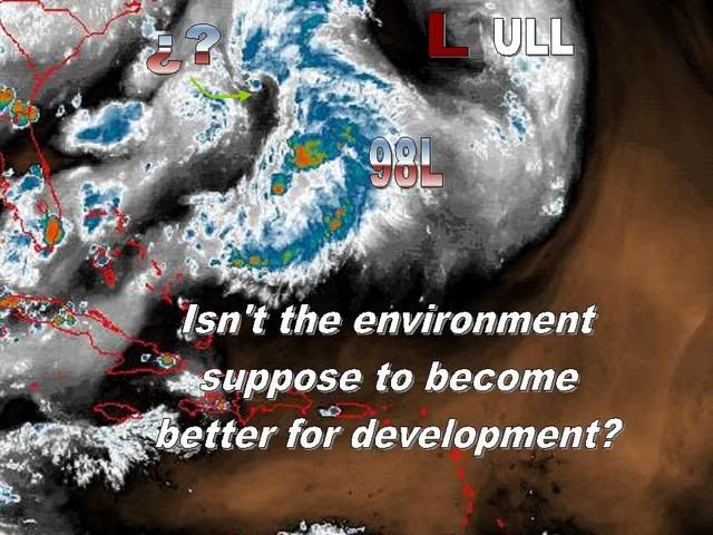
HURAKAN wrote:For our experts, do a loop on 30N 70W, is that a LLC or MLC?

http://wwwghcc.msfc.nasa.gov/GOES/goeseastconus.html


It looks to me to be more be at the surface but part of the broader low, it will be interesting to see if it becomes the main circulation or if it gets absorb by the broader circulation to its NW.
0 likes   

User avatar
fci
S2K Supporter
S2K Supporter
Posts: 3324
Joined: Tue Sep 14, 2004 10:29 am
Location: Lake Worth, FL

Re: Invest 98L in Western Atlantic

#269 Postby fci » Sun Jul 29, 2007 3:25 pm

miamicanes177 wrote:Jeff Masters said this morning he thought it would be a tropical depression by tuesday. He has gone back into that post and edited that out as well as a few other things. I've learned you have to read Master's blog as soon as possible and copy and paste what he says due to his editing techniques. Wouldn't it be nice as a forecaster to be able to change your forecast after the fact? You would be right 100% of the time. For Master to gain credibility he should leave his original post as is, and make the edits in red letters. That way it doesn't make him look bad.


I am not doubting your statement as I do not know you.
However, given that Dr. Masters is a Pro Met; you should provide an example of what you are talking about.
Copy his original and then paste it with the revision you are talking about.

Your assertion is pretty serious and should be backed up with the proof.

Look, I don't know Dr. Masters from Adam and have no opinion on the matter but just advise you provide proof with an accusation so as not to bring any criticism towards you.

fci
0 likes   

User avatar
HURAKAN
Professional-Met
Professional-Met
Posts: 46086
Age: 38
Joined: Thu May 20, 2004 4:34 pm
Location: Key West, FL
Contact:

#270 Postby HURAKAN » Sun Jul 29, 2007 3:27 pm

Image
0 likes   

User avatar
Normandy
Category 5
Category 5
Posts: 2293
Joined: Sun Oct 10, 2004 12:31 am
Location: Houston, TX

#271 Postby Normandy » Sun Jul 29, 2007 3:55 pm

This is an invest? Must have been a test of the software like wxman57 mentioned.....that thing looks extratropical.
0 likes   

RL3AO
Moderator-Pro Met
Moderator-Pro Met
Posts: 16308
Joined: Thu Jun 14, 2007 10:03 pm
Location: NC

#272 Postby RL3AO » Sun Jul 29, 2007 4:02 pm

000
ABNT20 KNHC 292100
TWOAT
TROPICAL WEATHER OUTLOOK
NWS TPC/NATIONAL HURRICANE CENTER MIAMI FL
530 PM EDT SUN JUL 29 2007

FOR THE NORTH ATLANTIC...CARIBBEAN SEA AND THE GULF OF MEXICO...

THERE HAS BEEN LITTLE CHANGE DURING THE DAY TO THE POORLY-ORGANIZED
LOW PRESSURE AREA CENTERED ROUGHLY 400 MILES WEST-SOUTHWEST OF
BERMUDA. ALTHOUGH UPPER-LEVEL WINDS ARE NOT PARTICULARLY FAVORABLE
FOR FURTHER ORGANIZATION AT THIS TIME...THIS SYSTEM STILL HAS SOME
POTENTIAL FOR TROPICAL OR SUBTROPICAL DEVELOPMENT OVER THE NEXT
COUPLE OF DAYS AS IT MOVES NORTH-NORTHEASTWARD AT 10 TO 15 MPH.
HEAVY RAIN ASSOCIATED WITH THE LOW COULD OVERSPREAD BERMUDA LATER
THIS EVENING AND OVERNIGHT. PLEASE SEE PRODUCTS ISSUED BY YOUR
LOCAL WEATHER SERVICE OFFICE FOR MORE DETAILS.

ELSEWHERE...TROPICAL CYCLONE FORMATION IS NOT EXPECTED DURING THE
NEXT 48 HOURS.

$$
FORECASTER BLAKE
0 likes   

philnyc
S2K Supporter
S2K Supporter
Posts: 313
Joined: Thu Jun 07, 2007 1:14 am
Location: Brooklyn, New York City, New York
Contact:

Re:

#273 Postby philnyc » Sun Jul 29, 2007 4:04 pm

Normandy wrote:This is an invest? Must have been a test of the software like wxman57 mentioned.....that thing looks extratropical.


Also, why don't they have a floater going for it? I just checked and all four floaters are inactive. Or am I missing something?
0 likes   

RL3AO
Moderator-Pro Met
Moderator-Pro Met
Posts: 16308
Joined: Thu Jun 14, 2007 10:03 pm
Location: NC

Re: Re:

#274 Postby RL3AO » Sun Jul 29, 2007 4:06 pm

philnyc wrote:

Also, why don't they have a floater going for it? I just checked and all four floaters are inactive. Or am I missing something?


Hmm...floater 1 was on it yesterday.
0 likes   

User avatar
HURAKAN
Professional-Met
Professional-Met
Posts: 46086
Age: 38
Joined: Thu May 20, 2004 4:34 pm
Location: Key West, FL
Contact:

Re: Re:

#275 Postby HURAKAN » Sun Jul 29, 2007 4:07 pm

RL3AO wrote:
philnyc wrote:

Also, why don't they have a floater going for it? I just checked and all four floaters are inactive. Or am I missing something?


Hmm...floater 1 was on it yesterday.


http://www.ssd.noaa.gov/PS/TROP/float1.html

Still there if you click.
0 likes   

User avatar
cycloneye
Admin
Admin
Posts: 145888
Age: 69
Joined: Thu Oct 10, 2002 10:54 am
Location: San Juan, Puerto Rico

Re: Invest 98L in Western Atlantic

#276 Postby cycloneye » Sun Jul 29, 2007 4:09 pm

:uarrow: But floater is not active as the last frame was at 16:15 UTC.
0 likes   

philnyc
S2K Supporter
S2K Supporter
Posts: 313
Joined: Thu Jun 07, 2007 1:14 am
Location: Brooklyn, New York City, New York
Contact:

Re: Invest 98L in Western Atlantic

#277 Postby philnyc » Sun Jul 29, 2007 4:17 pm

cycloneye wrote::uarrow: But floater is not active as the last frame was at 16:15 UTC.


Yes, and obviously the grid is way too far south now. The LLC is not on it. Wonder why they haven't updated it...
0 likes   

User avatar
HURAKAN
Professional-Met
Professional-Met
Posts: 46086
Age: 38
Joined: Thu May 20, 2004 4:34 pm
Location: Key West, FL
Contact:

#278 Postby HURAKAN » Sun Jul 29, 2007 4:19 pm

:uarrow: That's right. Sorry, I didn't notice. :uarrow:

Image

Latest!
0 likes   

philnyc
S2K Supporter
S2K Supporter
Posts: 313
Joined: Thu Jun 07, 2007 1:14 am
Location: Brooklyn, New York City, New York
Contact:

Re:

#279 Postby philnyc » Sun Jul 29, 2007 4:24 pm

HURAKAN wrote::uarrow: That's right. Sorry, I didn't notice. :uarrow:

Image

Latest!


Looks subtropical at best to me...
0 likes   

User avatar
NDG
S2K Supporter
S2K Supporter
Posts: 15455
Joined: Sun Jul 09, 2006 10:14 pm
Location: Orlando, FL

Re: Re:

#280 Postby NDG » Sun Jul 29, 2007 4:28 pm

philnyc wrote:
Looks subtropical at best to me...


That's a better statement than saying extratropical look to it, which conditions are not there to be extratropical.
0 likes   


Return to “Talkin' Tropics”

Who is online

Users browsing this forum: redingtonbeach and 46 guests