https://twitter.com/philklotzbach/status/1296211691059859456
https://twitter.com/philklotzbach/status/1296117897547280384
https://twitter.com/philklotzbach/status/1296119015379570688
https://twitter.com/webberweather/status/1296318316479488000
https://twitter.com/webberweather/status/1296319819596410880
2020 Indicators: SST's / SAL / MSLP / Steering / Shear / Instability / Sat Images
Moderator: S2k Moderators
Forum rules

The posts in this forum are NOT official forecasts and should not be used as such. They are just the opinion of the poster and may or may not be backed by sound meteorological data. They are NOT endorsed by any professional institution or STORM2K. For official information, please refer to products from the National Hurricane Center and National Weather Service.
-
Shell Mound
- Category 5

- Posts: 2432
- Age: 33
- Joined: Thu Sep 07, 2017 3:39 pm
- Location: St. Petersburg, FL → Scandinavia
Re: 2020 Indicators: SST's / SAL / MSLP / Steering / Shear / Instability / Sat Images
2 likes
CVW / MiamiensisWx / Shell Mound
The posts in this forum are NOT official forecasts and should not be used as such. They are just the opinion of the poster and may or may not be backed by sound meteorological data. They are NOT endorsed by any professional institution or STORM2K. For official information, please refer to products from the NHC and NWS.

Re: 2020 Indicators: SST's / SAL / MSLP / Steering / Shear / Instability / Sat Images
Something to think about, peak of the season is still 3 weeks from today. 
2 likes
-
USTropics
- Professional-Met

- Posts: 2738
- Joined: Sun Aug 12, 2007 3:45 am
- Location: Florida State University
Re: 2020 Indicators: SST's / SAL / MSLP / Steering / Shear / Instability / Sat Images
We are likely to be in a very active phase through at least September 15th:

4 likes

Re: 2020 Indicators: SST's / SAL / MSLP / Steering / Shear / Instability / Sat Images
Now that TD13 and TD14 have both formed, it’s a race to see which one will be named first. However, regardless of which one becomes Laura and which one becomes Marco, two records will fall: the earliest 12th and 13th named storms. Luis ‘95 holds the first record on August 29th, but will almost certainly be broken by 9 days. The record for the earliest 13th TS is held jointly by Maria ‘05 and Lee ‘11, on September 2nd. Depending on when we get Marco, that record will be obliterated by 12-13 days, and will pave the way for 2020 to be even further ahead of 2005.
0 likes
Irene '11 Sandy '12 Hermine '16 5/15/2018 Derecho Fay '20 Isaias '20 Elsa '21 Henri '21 Ida '21
I am only a meteorology enthusiast who knows a decent amount about tropical cyclones. Look to the professional mets, the NHC, or your local weather office for the best information.
I am only a meteorology enthusiast who knows a decent amount about tropical cyclones. Look to the professional mets, the NHC, or your local weather office for the best information.
-
supercane4867
- Category 5
- Posts: 4966
- Joined: Wed Nov 14, 2012 10:43 am
Re: 2020 Indicators: SST's / SAL / MSLP / Steering / Shear / Instability / Sat Images
At this point I think 2020 may very well exceeds 2005 at least in terms of quantity.
6 likes
-
tarheelprogrammer

- S2K Supporter

- Posts: 1793
- Joined: Mon Mar 28, 2016 9:25 pm
- Location: Raleigh, NC area (Garner, NC)
Re: 2020 Indicators: SST's / SAL / MSLP / Steering / Shear / Instability / Sat Images
supercane4867 wrote:At this point I think 2020 may very well exceeds 2005 at least in terms of quantity.
I believe the same, but I am leaning towards it not producing the same amount of quality, or even close to it. We shall see though. It only takes one storm, the saying has been played out but that is because it is true.
0 likes
My posts are not official forecasts. They are just my opinion and may or may not be backed by sound meteorological data. They are NOT endorsed by any professional institution or storm2k.org. For official information, please refer to the NHC and NWS products.
-
Shell Mound
- Category 5
- Posts: 2432
- Age: 33
- Joined: Thu Sep 07, 2017 3:39 pm
- Location: St. Petersburg, FL → Scandinavia
Re: 2020 Indicators: SST's / SAL / MSLP / Steering / Shear / Instability / Sat Images
0 likes
CVW / MiamiensisWx / Shell Mound
The posts in this forum are NOT official forecasts and should not be used as such. They are just the opinion of the poster and may or may not be backed by sound meteorological data. They are NOT endorsed by any professional institution or STORM2K. For official information, please refer to products from the NHC and NWS.

Re: 2020 Indicators: SST's / SAL / MSLP / Steering / Shear / Instability / Sat Images
I do have to ask what seem to be going on with the Atlantic at the moment, we have two systems seemingly struggling to even close off despite favorable conditions in late August and despite this massively favorable MJO moving into the basin. Seems like it's increasing convection but not convergence.
3 likes
The above post is not official and should not be used as such. It is the opinion of the poster and may or may not be backed by sound meteorological data. It is not endorsed by any professional institution or storm2k.org. For official information, please refer to the NHC and NWS products.
-
MarioProtVI
- Category 5
- Posts: 1034
- Age: 24
- Joined: Sun Sep 29, 2019 7:33 pm
- Location: New Jersey
Re: 2020 Indicators: SST's / SAL / MSLP / Steering / Shear / Instability / Sat Images
Hammy wrote:I do have to ask what seem to be going on with the Atlantic at the moment, we have two systems seemingly struggling to even close off despite favorable conditions in late August and despite this massively favorable MJO moving into the basin. Seems like it's increasing convection but not convergence.
Both storms are closed if you look close enough (in 14L’s case it was bad positioning by the NHC given the center is likely farther north). I think people are just impatient and tend to scream “season cancel” the minute something changes with a storm being weaker in favorable conditions due to slight land passing.
4 likes
-
tolakram
- Admin

- Posts: 20185
- Age: 62
- Joined: Sun Aug 27, 2006 8:23 pm
- Location: Florence, KY (name is Mark)
Re: 2020 Indicators: SST's / SAL / MSLP / Steering / Shear / Instability / Sat Images
Hammy wrote:I do have to ask what seem to be going on with the Atlantic at the moment, we have two systems seemingly struggling to even close off despite favorable conditions in late August and despite this massively favorable MJO moving into the basin. Seems like it's increasing convection but not convergence.
Well, some of the worst storms in US history struggled right up until they didn't. What I want to know is why people expect long trackers out of every storm? It's the struggling ones that make it in close that are the most dangerous.
13 likes
M a r k
- - - - -
Join us in chat: Storm2K Chatroom Invite. Android and IOS apps also available.
The posts in this forum are NOT official forecasts and should not be used as such. Posts are NOT endorsed by any professional institution or STORM2K.org. For official information and forecasts, please refer to NHC and NWS products.
-
TheStormExpert
Re: 2020 Indicators: SST's / SAL / MSLP / Steering / Shear / Instability / Sat Images
Hammy wrote:I do have to ask what seem to be going on with the Atlantic at the moment, we have two systems seemingly struggling to even close off despite favorable conditions in late August and despite this massively favorable MJO moving into the basin. Seems like it's increasing convection but not convergence.
Maybe it has something to do with the warmest SST anomalies being now located in the Subtropical Atlantic as opposed to the Tropical Atlantic? Otherwise I don’t know anymore.

1 likes
-
gatorcane

- S2K Supporter
- Posts: 23708
- Age: 48
- Joined: Sun Mar 13, 2005 3:54 pm
- Location: Boca Raton, FL
Re: 2020 Indicators: SST's / SAL / MSLP / Steering / Shear / Instability / Sat Images
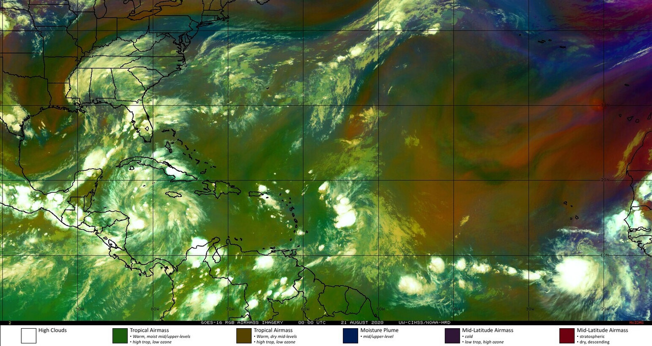
It looks *really* dry across much of the MDR particularly east of the Lesser Antilles. Look at all of the orange shading. I don't need a model to tell me these waves coming off Africa are going to have a tough time in that region. Even some oranges showing up in the SW Atlantic near the Greater Antilles which should help keep TD #13 at check. The Western Caribbean looks more moist though and TD #14 is trying to take advantage.
3 likes
Re: 2020 Indicators: SST's / SAL / MSLP / Steering / Shear / Instability / Sat Images
TheStormExpert wrote:Hammy wrote:I do have to ask what seem to be going on with the Atlantic at the moment, we have two systems seemingly struggling to even close off despite favorable conditions in late August and despite this massively favorable MJO moving into the basin. Seems like it's increasing convection but not convergence.
Maybe it has something to do with the warmest SST anomalies being now located in the Subtropical Atlantic as opposed to the Tropical Atlantic? Otherwise I don’t know anymore.
https://i.ibb.co/Pt4G8sc/coraltemp5km-ssta-20200819-west.gif
The water between is cooler, though the instability graph is pretty much where it was in early July. But then we're not exactly having a low-convection MDR.
3 likes
The above post is not official and should not be used as such. It is the opinion of the poster and may or may not be backed by sound meteorological data. It is not endorsed by any professional institution or storm2k.org. For official information, please refer to the NHC and NWS products.


Re: 2020 Indicators: SST's / SAL / MSLP / Steering / Shear / Instability / Sat Images
While the recent “struggles” of Josephine, 13L, and 14L and the continued presence of dry air in the MDR may tempt calling the potential of this season into question, I still believe this is quite the myopic thing to do. There are just too many ominous cues in place.
We are currently outpacing every season on record. In all likelihood, we will see the earliest L and M storms form in the next 24-36 hours, each breaking the previous record by over a week. Even if 13L or 14L fails to become a TS, what will likely soon be 99L over the coast of Africa has a solid chance of making up for it in a matter of days (and that’s not even counting TD 10, which I’d argue has a compelling chance of being upgraded to a TS in post-analysis). Yes, I see the counter argument that many have been weak and short lived. However, that is the norm even in hyperactive seasons for early-season (e.g. pre Aug 20th) activity. “But 2020 is no 2005. 2005 had Dennis and Emily!” Yes, Dennis and Emily were extremely powerful and significant early season storms. That being said, they came from overtly anomalous July conditions that were unusual even by 2005 standards. Let’s look at 2005 without these two storms for a second… we get a total of 26/13/5 for the season, and 7/2/0 up until this date. I’d argue that our 11/2/0 is equally as significant up to this point- Cindy was a minimal C1 and Irene was a moderate C2, but Hanna and Isaias were both quite impressive C1’s. I’d also argue that 26/13/5 isn’t all that far off from what we could as a total for this season when it’s all said and done.
Let’s go back to 13L and 14L for a second. Sure, 13L and 14L are struggling right now, but they are still both removed from their peak ‘windows of opportunity’, if you will. They may end up being non-events; they may end up being majors- it almost doesn’t really matter, because the bulk of the of the season lies in the next 6 weeks and when you have storms forming at the rate they are this year, some are bound to blow up in optimal environments eventually. It’s just going to get harder and harder for systems to not become hurricanes. We’ll just have to wait to see if this happens with 13/14. It’s also worth noting that Andrew, Harvey, Dorian, Katrina, etc. also struggled to get started- while most of us envision CV-Longtrackers like Irma as hallmarks of hyperactivity and destruction, the smaller systems that flounder until they suddenly don’t often pack an even nastier punch.
Some more points of note: and SST’s are comparable to the three most active seasons (2005, 2010, and 2017) in the 21st century so far, we are in a budding La Niña, and CSU (24/12/5), TSR (24/10/4), and NOAA (19-25/7-11/3-6)- the most experienced and renown agencies when it comes to seasonal forecasting, mind you- are all forecasting the most bullish season they’ve ever called for. I don’t think this is something to underestimate, especially as it is still only August 20th.
Of course, it would be great to be wrong, but to expect things to underperform from here on out is simply wish-casting in my opinion.
12 likes
-
ElectricStorm

- Category 5
- Posts: 5146
- Age: 25
- Joined: Tue Aug 13, 2019 11:23 pm
- Location: Norman, OK
Re: 2020 Indicators: SST's / SAL / MSLP / Steering / Shear / Instability / Sat Images
Looking back at the most recent hyperactive season, 2017, had 6 majors, one off the record of 7 set in 2005. The first one in 2017 was Harvey, which became a major around the same time that TD14 will be moving through the gulf this year (not saying that 14L will become a major, just using it as a timing comparison). There were still 5 more majors in September and October in 2017, and people then were cancelling that season based on the weak early activity just like they are this year. My point is, even if 13 and 14 don't become majors, that doesn't mean the entire season is going to be an underachiever. The conditions this year are going to be too favorable for this season to be a bust IMO
9 likes
B.S Meteorology, University of Oklahoma '25
Please refer to the NHC, NWS, or SPC for official information.
Please refer to the NHC, NWS, or SPC for official information.

Re: 2020 Indicators: SST's / SAL / MSLP / Steering / Shear / Instability / Sat Images
Does anyone know what the record is for most named storms landfalling in the US is? I know some storms have had multiple landfalls as well (e.g. Katrina = 3). I was looking for the year with the most named storm landfalls as well as year with the total number of landfalls. We have a reasonable chance of reaching 7 before the end of August which is probably pretty close if not the record for this early in the season. Thanks if anyone knows (looking at 1900, Hammy , Shell and anyone else who might have the stats). Thanks.
Last edited by Steve on Fri Aug 21, 2020 8:06 am, edited 1 time in total.
0 likes
Re: 2020 Indicators: SST's / SAL / MSLP / Steering / Shear / Instability / Sat Images
jconsor wrote:https://twitter.com/yconsor/status/1296790153856536579
Did the MJO bring some EPac bad luck or something?
0 likes
Irene '11 Sandy '12 Hermine '16 5/15/2018 Derecho Fay '20 Isaias '20 Elsa '21 Henri '21 Ida '21
I am only a meteorology enthusiast who knows a decent amount about tropical cyclones. Look to the professional mets, the NHC, or your local weather office for the best information.
I am only a meteorology enthusiast who knows a decent amount about tropical cyclones. Look to the professional mets, the NHC, or your local weather office for the best information.
-
tolakram
- Admin
- Posts: 20185
- Age: 62
- Joined: Sun Aug 27, 2006 8:23 pm
- Location: Florence, KY (name is Mark)
Re: 2020 Indicators: SST's / SAL / MSLP / Steering / Shear / Instability / Sat Images
My take is we won't know until the heart of the season passes and we start falling behind in the numbers game. It's too easy to get caught up in current storms and performance of those storms and not look at the big picture. Those always calling for busted seasonal forecasts are bound to be right every once in a while, but not for good reasons.
I challenge anyone who thinks the season is going to bust to present evidence and comparisons to any other season except 2005. If you take the time to do the comparison you'll see it's a bit too early to call the seasonal predictions into question.
I challenge anyone who thinks the season is going to bust to present evidence and comparisons to any other season except 2005. If you take the time to do the comparison you'll see it's a bit too early to call the seasonal predictions into question.
4 likes
M a r k
- - - - -
Join us in chat: Storm2K Chatroom Invite. Android and IOS apps also available.
The posts in this forum are NOT official forecasts and should not be used as such. Posts are NOT endorsed by any professional institution or STORM2K.org. For official information and forecasts, please refer to NHC and NWS products.
- - - - -
Join us in chat: Storm2K Chatroom Invite. Android and IOS apps also available.
The posts in this forum are NOT official forecasts and should not be used as such. Posts are NOT endorsed by any professional institution or STORM2K.org. For official information and forecasts, please refer to NHC and NWS products.
-
Shell Mound
- Category 5
- Posts: 2432
- Age: 33
- Joined: Thu Sep 07, 2017 3:39 pm
- Location: St. Petersburg, FL → Scandinavia
Re: 2020 Indicators: SST's / SAL / MSLP / Steering / Shear / Instability / Sat Images
https://twitter.com/PaulRoundy1/status/1296779979670290432
Does anyone know why this may be the case? Why would see more AWB-type events when most other parameters are conducive?
Does anyone know why this may be the case? Why would see more AWB-type events when most other parameters are conducive?
0 likes
CVW / MiamiensisWx / Shell Mound
The posts in this forum are NOT official forecasts and should not be used as such. They are just the opinion of the poster and may or may not be backed by sound meteorological data. They are NOT endorsed by any professional institution or STORM2K. For official information, please refer to products from the NHC and NWS.
Who is online
Users browsing this forum: Europa non è lontana and 507 guests