2020 Global Model Runs Discussion (Out thru day 16)

This is the general tropical discussion area. Anyone can take their shot at predicting a storms path.

Moderator: S2k Moderators

Forum rules

The posts in this forum are NOT official forecasts and should not be used as such. They are just the opinion of the poster and may or may not be backed by sound meteorological data. They are NOT endorsed by any professional institution or STORM2K. For official information, please refer to products from the National Hurricane Center and National Weather Service.

Help Support Storm2K
Message
Author
User avatar
blp
Category 5
Category 5
Posts: 2840
Age: 46
Joined: Thu Sep 09, 2004 7:51 pm
Location: Miami, FL
Contact:

Re: 2020 Global Model Runs Discussion (Out thru day 16)

#2601 Postby blp » Thu Sep 24, 2020 12:10 am

Hurricaneman wrote:seems as though slowly the GFS is trending towards the EPAC with this system


It does like that way or gets buried in C. America. The 00zCMC now shows the original rotation getting buried in C. America just like the GFS. So at least there is some agreement now on that evolution. Look for the GFS to latch onto the tail of front which happens later on as a possible new area emerging in the NW Carribean.

Image
0 likes   
The following post is NOT an official forecast and should not be used as such. It is just the opinion of the poster and may or may not be backed by sound meteorological data. It is NOT endorsed by any professional institution including storm2k.org For Official Information please refer to the NHC and NWS products.

User avatar
SouthFLTropics
Category 5
Category 5
Posts: 4236
Age: 50
Joined: Thu Aug 14, 2003 8:04 am
Location: Port St. Lucie, Florida

Re: 2020 Global Model Runs Discussion (Out thru day 16)

#2602 Postby SouthFLTropics » Thu Sep 24, 2020 1:35 am

The 00z GEFS from Hour 126 to 384, Western Atlantic and EPac for comparison. It looks like activity picks up in the EPac earlier and then the timeframe for the Caribbean has been moved back. Could this be in relation to the MJO phase or a passing Kelvin Wave?

Image

Image
0 likes   
Fourth Generation Florida Native

Personal Storm History: David 79, Andrew 92, Erin 95, Floyd 99, Irene 99, Frances 04, Jeanne 04, Wilma 05, Matthew 16, Irma 17, Ian 22, Nicole 22, Milton 24

ClarCari
Category 2
Category 2
Posts: 579
Joined: Thu Aug 13, 2020 11:02 am

Re: 2020 Global Model Runs Discussion (Out thru day 16)

#2603 Postby ClarCari » Thu Sep 24, 2020 2:16 am

SouthFLTropics wrote:The 00z GEFS from Hour 126 to 384, Western Atlantic and EPac for comparison. It looks like activity picks up in the EPac earlier and then the timeframe for the Caribbean has been moved back. Could this be in relation to the MJO phase or a passing Kelvin Wave?

https://i.imgur.com/WIlF2xZ.gif

https://i.imgur.com/Ohq0eLL.gif

I believe so! The activity is expected to explode around week 2 of October and persist into some of November.
That also should coincide with the cold front tapering off. By the time the Atlantic becomes more favorable again, the cold front and whatever shear and air stability it brings will decrease leading to a pretty “spooky” :lol: October setup for development.

As for the EPAC...ehh maybeee another Cat.4 or so major and most likely a storm or two. The models that start switching into the EPAC maybe hinting at another bigger storm going on over there before that season goes dud again lol.
0 likes   

User avatar
Kingarabian
S2K Supporter
S2K Supporter
Posts: 15986
Joined: Sat Aug 08, 2009 3:06 am
Location: Honolulu, Hawaii

Re: 2020 Global Model Runs Discussion (Out thru day 16)

#2604 Postby Kingarabian » Thu Sep 24, 2020 2:30 am

GFS's EPAC activity uptick forecast is likely bogus. I would look for TC development in the W-Caribbean/GOM instead.
7 likes   
RIP Kobe Bryant

storminabox
Category 1
Category 1
Posts: 263
Joined: Sun Jul 09, 2017 10:50 pm

Re: 2020 Global Model Runs Discussion (Out thru day 16)

#2605 Postby storminabox » Thu Sep 24, 2020 3:27 am

gatorcane wrote:
Nuno wrote:
gatorcane wrote:The more interesting thing to me looking at the models is the major cold front both the GFS and Euro show plunging deep into the Gulf and through Florida. :eek: Looks like something you would see in late October or November. The GFS seems to think a lot of shear will be over the NW Carib and Gulf should something decide to move north. Of course we all know how that worked out for Sally but this time the Euro is on board with the massive front as well.

https://i.postimg.cc/t4wSJVcM/gfs-T2ma-us-fh120-240.gif
https://i.postimg.cc/PrczQnML/ecmwf-T850a-us-fh120-240.gif


What about that massive front that was posted here constantly after Laura? It wasn't what the GFS kept predicting.


The GFS was basically alone with the front after Laura, not this time though. Other global models are on board. Seems some kind of front is one the way next week. May not necessarily be a good thing though.


Climatology supports it as well. Much more likely to get a front like this in early October than late August.
1 likes   

User avatar
abajan
S2K Supporter
S2K Supporter
Posts: 4234
Joined: Sun Sep 07, 2003 5:10 am
Location: Barbados

Re: 2020 Global Model Runs Discussion (Out thru day 16)

#2606 Postby abajan » Thu Sep 24, 2020 4:12 am

Let's see if this keeps showing up in the next few runs:

Image
5 likes   

User avatar
SFLcane
S2K Supporter
S2K Supporter
Posts: 10163
Age: 47
Joined: Sat Jun 05, 2010 1:44 pm
Location: Lake Worth Florida

Re: 2020 Global Model Runs Discussion (Out thru day 16)

#2607 Postby SFLcane » Thu Sep 24, 2020 5:32 am

EPS is a bit more active overnight with a few moderate tc’s affecting FL.

Image
Last edited by SFLcane on Thu Sep 24, 2020 5:44 am, edited 1 time in total.
1 likes   

User avatar
SFLcane
S2K Supporter
S2K Supporter
Posts: 10163
Age: 47
Joined: Sat Jun 05, 2010 1:44 pm
Location: Lake Worth Florida

Re: 2020 Global Model Runs Discussion (Out thru day 16)

#2608 Postby SFLcane » Thu Sep 24, 2020 5:36 am

Kingarabian wrote:GFS's EPAC activity uptick forecast is likely bogus. I would look for TC development in the W-Caribbean/GOM instead.


It’s favored by the EPS so that makes perfect sense actually to me. We shall see but I bet the GFS will probably drop the bogus tc soon
1 likes   

User avatar
SFLcane
S2K Supporter
S2K Supporter
Posts: 10163
Age: 47
Joined: Sat Jun 05, 2010 1:44 pm
Location: Lake Worth Florida

Re: 2020 Global Model Runs Discussion (Out thru day 16)

#2609 Postby SFLcane » Thu Sep 24, 2020 5:49 am

And there you have it! Bogus tc gone from the Atlantic development heavily favored in the Epac. Looking forward to some cool weather next week. :wink:

Image

Image
Last edited by SFLcane on Thu Sep 24, 2020 5:56 am, edited 1 time in total.
0 likes   

Shell Mound
Category 5
Category 5
Posts: 2434
Age: 32
Joined: Thu Sep 07, 2017 3:39 pm
Location: St. Petersburg, FL → Scandinavia

Re: 2020 Global Model Runs Discussion (Out thru day 16)

#2610 Postby Shell Mound » Thu Sep 24, 2020 5:50 am

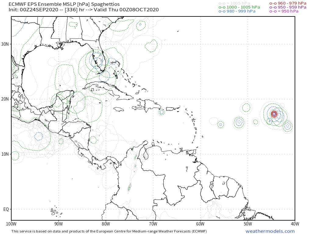
Spacecoast wrote:21 Hurricanes have crossed the Yucatan Channel during Oct / Nov(all recorded years).
The majority of these (12, or 57%) have hit Florida. Naples, Cape Coral, and Panama City seem to be climatologically popular.

2018 MICHAEL PANAMA CITY CAT5
2009 IDA PENSACOLA ET
2005 WILMA NAPLES CAT3
1964 ISBELL NAPLES CAT2
1948 UNNAMED KEYS / MIAMI CAT2
1946 UNNAMED TAMPA CAT1
1924 UNNAMED EVERGLADES / MIAMI CAT1
1921 UNNAMED TAMPA CAT3
1910 UNNAMED CAPE CORAL CAT2

1894 UNNAMED PANAMA CITY CAT3
1873 UNNAMED CAPE CORAL CAT3
1852 UNNAMED APALACHICOLA CAT2

https://i.ibb.co/THDLyQr/Capture6.jpg

Note that Ida (2009) was extratropical at landfall. If one excludes Ida and counts the remaining eleven cases, then eight (73%) of the remainder struck the FL peninsula from Tampa Bay southward. So if a hurricane were to pass through the Yucatán Channel during the months of October and/or November, it would be most likely to impact Central and/or South Florida (peninsular) as a hurricane. Based on historical data, Cat-3 status (105 knots) seems to be the uppermost boundary for these cases at landfall, given the influence of strong vertical wind shear related to incoming autumnal troughs, along with relatively cooler SSTs in the Gulf during October/November vs. August/September. So the fact that Central/South Florida has not been impacted by a major hurricane yet is potentially very good news, since most of the region’s Cat-4+ hits have been related to CV-type, MDR-related activity during the peak months of August and September. (The exception, Cat-4 King ‘50, originated in the W Caribbean in October 1950, but actually headed NNW into Miami: an extremely unusual trajectory and location for the month of October.) So if we get a W-Caribbean major hurricane that tracks through the Channel and impacts Central/South FL, it would almost certainly be no stronger than a Cat-3 at landfall, and would more likely be weakening and/or steady-state than a MH impacting the same region in August/September. Again, very good news. Another Wilma would not be pleasant, but certainly much better than a Cat-4+.
0 likes   
CVW / MiamiensisWx / Shell Mound
The posts in this forum are NOT official forecasts and should not be used as such. They are just the opinion of the poster and may or may not be backed by sound meteorological data. They are NOT endorsed by any professional institution or STORM2K. For official information, please refer to products from the NHC and NWS.

User avatar
SFLcane
S2K Supporter
S2K Supporter
Posts: 10163
Age: 47
Joined: Sat Jun 05, 2010 1:44 pm
Location: Lake Worth Florida

Re: 2020 Global Model Runs Discussion (Out thru day 16)

#2611 Postby SFLcane » Thu Sep 24, 2020 6:20 am

As soon as it got to 10 days out GFS switched. EPS does indicate a late-season fish MDR storm
0 likes   

AutoPenalti
Category 5
Category 5
Posts: 4030
Age: 29
Joined: Mon Aug 17, 2015 4:16 pm
Location: Ft. Lauderdale, Florida

Re: 2020 Global Model Runs Discussion (Out thru day 16)

#2612 Postby AutoPenalti » Thu Sep 24, 2020 6:56 am

No surprises there.
1 likes   
The posts in this forum are NOT official forecasts and should not be used as such. They are just the opinion of the poster and may or may not be backed by sound meteorological data. They are NOT endorsed by any professional institution or STORM2K. For official information, please refer to products from the NHC and NWS.


Model Runs Cheat Sheet:
GFS (5:30 AM/PM, 11:30 AM/PM)
HWRF, GFDL, UKMET, NAVGEM (6:30-8:00 AM/PM, 12:30-2:00 AM/PM)
ECMWF (1:45 AM/PM)

TCVN
is a weighted averaged

User avatar
aspen
Category 5
Category 5
Posts: 8818
Joined: Sat Oct 12, 2019 7:10 pm
Location: Connecticut, USA

Re: 2020 Global Model Runs Discussion (Out thru day 16)

#2613 Postby aspen » Thu Sep 24, 2020 7:34 am

Kingarabian wrote:GFS's EPAC activity uptick forecast is likely bogus. I would look for TC development in the W-Caribbean/GOM instead.

For every 1 Atlantic phantom, there have been multiple EPac phantoms. The GFS and Euro have constantly been way too excited about EPac development, and I assume this is once again the case.
1 likes   
Irene '11 Sandy '12 Hermine '16 5/15/2018 Derecho Fay '20 Isaias '20 Elsa '21 Henri '21 Ida '21

I am only a meteorology enthusiast who knows a decent amount about tropical cyclones. Look to the professional mets, the NHC, or your local weather office for the best information.

User avatar
toad strangler
S2K Supporter
S2K Supporter
Posts: 4543
Joined: Sun Jul 28, 2013 3:09 pm
Location: Earth
Contact:

Re: 2020 Global Model Runs Discussion (Out thru day 16)

#2614 Postby toad strangler » Thu Sep 24, 2020 7:38 am

Every year at this time this happens with the GFS
1 likes   

User avatar
DestinHurricane
Category 4
Category 4
Posts: 935
Joined: Tue May 01, 2018 8:05 am
Location: New York, NY

Re: 2020 Global Model Runs Discussion (Out thru day 16)

#2615 Postby DestinHurricane » Thu Sep 24, 2020 7:43 am

I see GFS has dropped it. Is it now safe to say this potential TC is not happening in the Caribbean or Gulf?
0 likes   
Michael 2018

User avatar
SFLcane
S2K Supporter
S2K Supporter
Posts: 10163
Age: 47
Joined: Sat Jun 05, 2010 1:44 pm
Location: Lake Worth Florida

Re: 2020 Global Model Runs Discussion (Out thru day 16)

#2616 Postby SFLcane » Thu Sep 24, 2020 7:51 am

DestinHurricane wrote:I see GFS has dropped it. Is it now safe to say this potential TC is not happening in the Caribbean or Gulf?


Probably not during the next 2 weeks but there will a chance during October conditions favor it as MJO moves in. Then again we have been looking at the Caribbean for development for years now and it doesn’t produce. We shall see
0 likes   

User avatar
DestinHurricane
Category 4
Category 4
Posts: 935
Joined: Tue May 01, 2018 8:05 am
Location: New York, NY

Re: 2020 Global Model Runs Discussion (Out thru day 16)

#2617 Postby DestinHurricane » Thu Sep 24, 2020 7:57 am

SFLcane wrote:
DestinHurricane wrote:I see GFS has dropped it. Is it now safe to say this potential TC is not happening in the Caribbean or Gulf?


Probably not during the next 2 weeks but there will a chance during October conditions favor it as MJO moves in. Then again we have been looking at the Caribbean for development for years now and it doesn’t produce. We shall see


The one on models we have been talking about though. Now near 0% chance?
0 likes   
Michael 2018

User avatar
chris_fit
Category 5
Category 5
Posts: 3222
Age: 42
Joined: Wed Sep 10, 2003 11:58 pm
Location: Tampa Bay Area, FL

Re: 2020 Global Model Runs Discussion (Out thru day 16)

#2618 Postby chris_fit » Thu Sep 24, 2020 8:10 am

GFS ENS
CAN ENS
EURO ENS

All still hinting at something in the W Carib.
2 likes   

User avatar
CourierPR
Category 5
Category 5
Posts: 1335
Age: 71
Joined: Tue Aug 31, 2004 7:53 pm
Location: Pompano Beach, Florida

Re: 2020 Global Model Runs Discussion (Out thru day 16)

#2619 Postby CourierPR » Thu Sep 24, 2020 8:11 am

So if we get a W-Caribbean major hurricane that tracks through the Channel and impacts Central/South FL, it would almost certainly be no stronger than a Cat-3 at landfall, and would more likely be weakening and/or steady-state than a MH impacting the same region in August/September. Again, very good news. Another Wilma would not be pleasant, but certainly much better than a Cat-4+.[/quote]


And you have a degree in meteorology? What you present as "very good news" is your version. I lived through Wilma and spent over a week without electricity here in Southeast Florida. Also, many homes had roofs covered by blue tarps for many months.
1 likes   

User avatar
SFLcane
S2K Supporter
S2K Supporter
Posts: 10163
Age: 47
Joined: Sat Jun 05, 2010 1:44 pm
Location: Lake Worth Florida

Re: 2020 Global Model Runs Discussion (Out thru day 16)

#2620 Postby SFLcane » Thu Sep 24, 2020 8:13 am

DestinHurricane wrote:
SFLcane wrote:
DestinHurricane wrote:I see GFS has dropped it. Is it now safe to say this potential TC is not happening in the Caribbean or Gulf?


Probably not during the next 2 weeks but there will a chance during October conditions favor it as MJO moves in. Then again we have been looking at the Caribbean for development for years now and it doesn’t produce. We shall see


The one on models we have been talking about though. Now near 0% chance?


Yep, it seems as we got bit or I should say “ me ”by the gfs phantom fantasy fest yet again. This model clearly for years has bias issues in the western Caribbean developing spurious tc’s. this time of the year for some reason. Until there is real support from other models like EPS inside 7-10 days it’s like nada. Tropics look closed next week or two with no rising motion overhead.
0 likes   


Return to “Talkin' Tropics”

Who is online

Users browsing this forum: Sciencerocks, Steve H. and 28 guests