
2020 Global Model Runs Discussion (Out thru day 16)
Moderator: S2k Moderators
Forum rules

The posts in this forum are NOT official forecasts and should not be used as such. They are just the opinion of the poster and may or may not be backed by sound meteorological data. They are NOT endorsed by any professional institution or STORM2K. For official information, please refer to products from the National Hurricane Center and National Weather Service.
-
SFLcane

- S2K Supporter

- Posts: 10281
- Age: 48
- Joined: Sat Jun 05, 2010 1:44 pm
- Location: Lake Worth Florida
Re: 2020 Global Model Runs Discussion (Out thru day 16)
boca wrote:Aren’t we in the suppression phase of the mjo right now?
Right around the time the CMC and GEFS are showing development.
https://twitter.com/mjventrice/status/1309552716897804288
Last edited by SFLcane on Fri Sep 25, 2020 1:02 pm, edited 1 time in total.
0 likes
-
Spacecoast

- Category 2

- Posts: 773
- Joined: Thu Aug 31, 2017 2:03 pm
Re: 2020 Global Model Runs Discussion (Out thru day 16)
00z GEPS, 12z CMC, and 12z GEFS all have something W of Jamaica @240.
GEPS wants to take into the Gulf via Yucatan channel
GEFS wants to ride E coast of FL
GFS Operation goes through Yucatan like Opal
GEPS wants to take into the Gulf via Yucatan channel
GEFS wants to ride E coast of FL
GFS Operation goes through Yucatan like Opal
0 likes
-
gatorcane

- S2K Supporter
- Posts: 23708
- Age: 48
- Joined: Sun Mar 13, 2005 3:54 pm
- Location: Boca Raton, FL
Re: 2020 Global Model Runs Discussion (Out thru day 16)
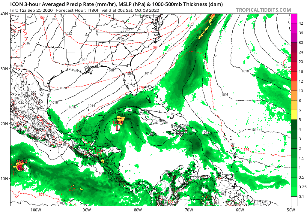
ICON for the first time has a broad low:
0 likes
-
SFLcane
- S2K Supporter
- Posts: 10281
- Age: 48
- Joined: Sat Jun 05, 2010 1:44 pm
- Location: Lake Worth Florida
Re: 2020 Global Model Runs Discussion (Out thru day 16)
gatorcane wrote:ICON for the first time has a broad low:
https://i.postimg.cc/qBbZWZZf/icon-mslp-pcpn-watl-60.png
Hi gatorcane, it’s not the first time.

0 likes
Re: 2020 Global Model Runs Discussion (Out thru day 16)
Maybe and this one could be for real (who knows?) but now we're seeing actual time slippage in the operational GFS. Remember all of those runs that had genesis ~10/2-4? This doesn't have it til several days later.
0 likes
Personal Forecast Disclaimer:
The posts in this forum are NOT official forecasts and should not be used as such. They are just the opinion of the poster and may or may not be backed by sound meteorological data. They are NOT endorsed by any professional institution or storm2k.org. For official information, please refer to the NHC and NWS products.
The posts in this forum are NOT official forecasts and should not be used as such. They are just the opinion of the poster and may or may not be backed by sound meteorological data. They are NOT endorsed by any professional institution or storm2k.org. For official information, please refer to the NHC and NWS products.

Re: 2020 Global Model Runs Discussion (Out thru day 16)
Nearly a week since the WCar storm first popped up on the GFS, and the following trends have favored this coming to fruition — the time frame remains consistent around October 2nd-5th, we can identify the source of its genesis, the ensembles have been relatively consistent, and the CMC and ICON have begun to show the disturbance as we get within 8-10 days of development. We’re still too far out to know any specifics in regards to intensity or track, and there are still plenty of possible solutions on the table, from a sloppy fast-mover to a slow-moving major. Still, it does not look like a ghost storm anymore.
4 likes
Irene '11 Sandy '12 Hermine '16 5/15/2018 Derecho Fay '20 Isaias '20 Elsa '21 Henri '21 Ida '21
I am only a meteorology enthusiast who knows a decent amount about tropical cyclones. Look to the professional mets, the NHC, or your local weather office for the best information.
I am only a meteorology enthusiast who knows a decent amount about tropical cyclones. Look to the professional mets, the NHC, or your local weather office for the best information.
Re: 2020 Global Model Runs Discussion (Out thru day 16)
aspen wrote:Nearly a week since the WCar storm first popped up on the GFS, and the following trends have favored this coming to fruition — the time frame remains consistent around October 2nd-5th, we can identify the source of its genesis, the ensembles have been relatively consistent, and the CMC and ICON have begun to show the disturbance as we get within 8-10 days of development. We’re still too far out to know any specifics in regards to intensity or track, and there are still plenty of possible solutions on the table, from a sloppy fast-mover to a slow-moving major. Still, it does not look like a ghost storm anymore.
Overall, I agree. However, the 12Z GFS's genesis is slipped back a few days from when the GFS had them ~10/2-4 in many runs earlier this week and into late last week.
0 likes
Personal Forecast Disclaimer:
The posts in this forum are NOT official forecasts and should not be used as such. They are just the opinion of the poster and may or may not be backed by sound meteorological data. They are NOT endorsed by any professional institution or storm2k.org. For official information, please refer to the NHC and NWS products.
The posts in this forum are NOT official forecasts and should not be used as such. They are just the opinion of the poster and may or may not be backed by sound meteorological data. They are NOT endorsed by any professional institution or storm2k.org. For official information, please refer to the NHC and NWS products.
-
TheStormExpert
-
chris_fit

- Category 5

- Posts: 3261
- Age: 43
- Joined: Wed Sep 10, 2003 11:58 pm
- Location: Tampa Bay Area, FL
Re: 2020 Global Model Runs Discussion (Out thru day 16)
TheStormExpert wrote:Nada from the operational 12z Euro.
12Z EPS not too enthused either. Maybe a slight uptick from the 00Z Run.
Of all the models this year though, Euro/EPS has not had a good history of pickup on cyclogenesis.
0 likes
-
TheStormExpert
Re: 2020 Global Model Runs Discussion (Out thru day 16)
chris_fit wrote:TheStormExpert wrote:Nada from the operational 12z Euro.
12Z EPS not too enthused either. Maybe a slight uptick from the 00Z Run.
Of all the models this year though, Euro/EPS has not had a good history of pickup on cyclogenesis.
Maybe just like in August when the MJO was forecasted to pass through the East Pacific and into the Atlantic the models might be overdoing the MJO in the East Pacific, since we do have a La Niña and not an El Niño so the East Pacific shouldn’t see too much (if any) activity in October due to the La Niña.
Maybe we should nowcast as seeing how horrible the models have done overall with TCG this season.
6 likes
-
Spacecoast
- Category 2
- Posts: 773
- Joined: Thu Aug 31, 2017 2:03 pm
Re: 2020 Global Model Runs Discussion (Out thru day 16)
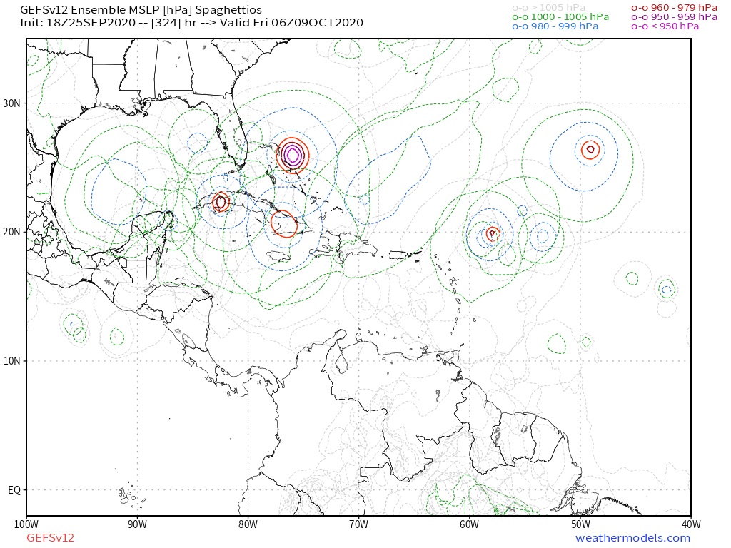
Significant upgrade from 3 days ago. Moderate confidence to high confidence.
I wonder what caused Harnos to change.

"The only change to the Week-2 TC formation areas was increasing the Western Caribbean to high confidence given increased signals in the ECMWF and GEFS models. The GEFS develops a TC further east than the ECMWF, but both models strongly support a system forming which would bear monitoring throughout the region and for U.S. interests along the Gulf Coast. "
Perhaps Bastardi was right.. At least one more storm of some kind will impact somebody, somewhere, sometime in the future.
Going out on a limb, I am getting bullish on a system developing south of Haiti/DR @ 180hr, then W of Jamaica @240, then cutting N over mid Cuba (maybe as far W as Havana), then NE over extreme SE FL / Bahamas
I wonder what caused Harnos to change.
"The only change to the Week-2 TC formation areas was increasing the Western Caribbean to high confidence given increased signals in the ECMWF and GEFS models. The GEFS develops a TC further east than the ECMWF, but both models strongly support a system forming which would bear monitoring throughout the region and for U.S. interests along the Gulf Coast. "
Perhaps Bastardi was right.. At least one more storm of some kind will impact somebody, somewhere, sometime in the future.
Going out on a limb, I am getting bullish on a system developing south of Haiti/DR @ 180hr, then W of Jamaica @240, then cutting N over mid Cuba (maybe as far W as Havana), then NE over extreme SE FL / Bahamas
2 likes
-
TheStormExpert
Re: 2020 Global Model Runs Discussion (Out thru day 16)
Spacecoast wrote:Significant upgrade from 3 days ago. Moderate confidence to high confidence.
I wonder what caused Harnos to change.
https://i.ibb.co/3z3dgBk/gth-full-update.png
"The only change to the Week-2 TC formation areas was increasing the Western Caribbean to high confidence given increased signals in the ECMWF and GEFS models. The GEFS develops a TC further east than the ECMWF, but both models strongly support a system forming which would bear monitoring throughout the region and for U.S. interests along the Gulf Coast. "
Perhaps Bastardi was right.. At least one more storm of some kind will impact somebody, somewhere, sometime in the future.
Going out on a limb, I am getting bullish on a system developing south of Haiti/DR @ 180hr, then W of Jamaica @240, then cutting N over mid Cuba (maybe as far W as Havana), then NE over extreme SE FL / Bahamas
Probably disregarding the models as they’ve been garbage this year.
1 likes
Re: 2020 Global Model Runs Discussion (Out thru day 16)
chris_fit wrote:TheStormExpert wrote:Nada from the operational 12z Euro.
12Z EPS not too enthused either. Maybe a slight uptick from the 00Z Run.
Of all the models this year though, Euro/EPS has not had a good history of pickup on cyclogenesis.
I agree with everything you said here. I counted 11 sub 1,000 mb TCs on the 12Z EPS vs 9 on the 0Z EPS. So, a slight uptick but not an overwhelmingly bullish signal either. But as you said, the EPS has been a bit shy much of the season.
0 likes
Personal Forecast Disclaimer:
The posts in this forum are NOT official forecasts and should not be used as such. They are just the opinion of the poster and may or may not be backed by sound meteorological data. They are NOT endorsed by any professional institution or storm2k.org. For official information, please refer to the NHC and NWS products.
The posts in this forum are NOT official forecasts and should not be used as such. They are just the opinion of the poster and may or may not be backed by sound meteorological data. They are NOT endorsed by any professional institution or storm2k.org. For official information, please refer to the NHC and NWS products.
-
Blown Away

- S2K Supporter
- Posts: 10253
- Joined: Wed May 26, 2004 6:17 am
Re: 2020 Global Model Runs Discussion (Out thru day 16)
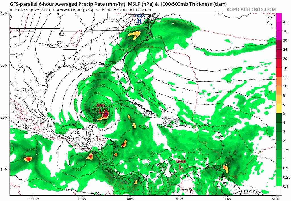
18z GFS has a TS in the mid range, @288 hrs, and moves from NW Caribbean and then into FL Big Bend area... GFS keeps moving this low from long to mid range, so consistent...
0 likes
Hurricane Eye Experience: David 79, Irene 99, Frances 04, Jeanne 04, Wilma 05… Hurricane Brush Experience: Andrew 92, Erin 95, Floyd 99, Matthew 16, Irma 17, Ian 22, Nicole 22…
-
TheStormExpert
Re: 2020 Global Model Runs Discussion (Out thru day 16)
A poorly organized 1004mb low is nothing to loose sleep over on the 18z GFS. Wake me up when things get more interesting. 
0 likes
-
SFLcane
- S2K Supporter
- Posts: 10281
- Age: 48
- Joined: Sat Jun 05, 2010 1:44 pm
- Location: Lake Worth Florida
Re: 2020 Global Model Runs Discussion (Out thru day 16)
TheStormExpert wrote:A poorly organized 1004mb low is nothing to loose sleep over on the 18z GFS. Wake me up when things get more interesting.
18z gfs ensembles still active paint a very different picture.
Last edited by SFLcane on Fri Sep 25, 2020 7:06 pm, edited 1 time in total.
0 likes
-
cheezyWXguy

- Category 5
- Posts: 6282
- Joined: Mon Feb 13, 2006 12:29 am
- Location: Dallas, TX
Re: 2020 Global Model Runs Discussion (Out thru day 16)
A lot of continued discrepancy on the gfs and gefs between the 18z and it’s previous runs, although the timeframe is consistent. Only real takeaway is something we already know: that there is an increased likelihood of formation to some degree in the Caribbean in about 7 days. Not much else though
0 likes
Who is online
Users browsing this forum: cajungal and 141 guests