2021 Indicators: SST's / SAL / MSLP / Shear / Steering / Instability / Sat Images

This is the general tropical discussion area. Anyone can take their shot at predicting a storms path.

Moderator: S2k Moderators

Forum rules

The posts in this forum are NOT official forecasts and should not be used as such. They are just the opinion of the poster and may or may not be backed by sound meteorological data. They are NOT endorsed by any professional institution or STORM2K. For official information, please refer to products from the National Hurricane Center and National Weather Service.

Help Support Storm2K
Message
Author
User avatar
Category5Kaiju
Category 5
Category 5
Posts: 4097
Joined: Thu Dec 24, 2020 12:45 pm
Location: Seattle

Re: 2021 Indicators: SST's / SAL / MSLP / Shear / Steering / Instability / Sat Images

#2761 Postby Category5Kaiju » Sat Aug 21, 2021 8:17 pm


With this potential storm as well as perhaps at least one in the open Atlantic sometime before the end of the month, we would already have 10 NSs by then conceivably, and this rate of NS formation has really been only surpassed by several years on record, with 2005 and 2020 being the most conspicuous examples. I knew those season cancel posts earlier this year with a dead July and what people thought would be an unfavorable MDR given its sst anomalies were not "as impressive" as expected would not hold much merit as we entered the second half of August.
0 likes   
Unless explicitly stated, all info in my posts is based on my own opinions and observations. Tropical storms and hurricanes can be extremely dangerous. Do not think you can beat Mother Nature. Refer to an accredited weather research agency or meteorologist if you need to make serious decisions regarding an approaching storm.

User avatar
weeniepatrol
Category 5
Category 5
Posts: 1276
Joined: Sat Aug 22, 2020 5:30 pm
Location: WA State

Re: 2021 Indicators: SST's / SAL / MSLP / Shear / Steering / Instability / Sat Images

#2762 Postby weeniepatrol » Sun Aug 22, 2021 12:50 am

Presented without comment


Can't wait to see what the MDR looks like after this CCKW passes through :double:
5 likes   

User avatar
chaser1
S2K Supporter
S2K Supporter
Posts: 5464
Age: 64
Joined: Sat Oct 15, 2005 5:59 pm
Location: Longwood, Fl

Re: 2021 Indicators: SST's / SAL / MSLP / Shear / Steering / Instability / Sat Images

#2763 Postby chaser1 » Sun Aug 22, 2021 11:38 am

Steve wrote:^^ appears to be so. Scroll down to VPM Indices.

http://mikeventrice.weebly.com/mjo.html


All indicators at this point suggesting heavy west Atlantic bias with regard to both genesis AND overall tracks. Pretty hard for me to see the Yucatan, Texas coast, and E. Florida coast escaping from some kind of storm impact over the coming 1-3 weeks. If I were to guess where I think the greatest threat might originate, might be any large long tracker from the E. MDR. passing north of the Greater Antilles and quite similar to Hugo's track (minus the PR landfall hopefully).
1 likes   
Andy D

(For official information, please refer to the NHC and NWS products.)

IcyTundra
Category 5
Category 5
Posts: 1205
Joined: Mon Jun 07, 2021 9:32 pm
Location: Dickinson, Texas

Re: 2021 Indicators: SST's / SAL / MSLP / Shear / Steering / Instability / Sat Images

#2764 Postby IcyTundra » Sun Aug 22, 2021 12:59 pm

0 likes   

User avatar
gatorcane
S2K Supporter
S2K Supporter
Posts: 23691
Age: 47
Joined: Sun Mar 13, 2005 3:54 pm
Location: Boca Raton, FL

Re: 2021 Indicators: SST's / SAL / MSLP / Shear / Steering / Instability / Sat Images

#2765 Postby gatorcane » Sun Aug 22, 2021 2:33 pm

Certainly hope Henri is not an indicator the models might seriously underestimate strengths of ridges this season like we have seen in recent years before (Irma, Matthew, etc):

Click for graphical archive loop of track. Talk about some big shifts to the west :eek:
https://www.nhc.noaa.gov/archive/2021/H ... _with_line
1 likes   

IcyTundra
Category 5
Category 5
Posts: 1205
Joined: Mon Jun 07, 2021 9:32 pm
Location: Dickinson, Texas

Re: 2021 Indicators: SST's / SAL / MSLP / Shear / Steering / Instability / Sat Images

#2766 Postby IcyTundra » Sun Aug 22, 2021 2:45 pm

gatorcane wrote:Certainly hope Henri is not an indicator the models might seriously underestimate strengths of ridges this season like we have seen in recent years before (Irma, Matthew, etc):

Click for graphical archive loop of track. Talk about some big shifts to the west :eek:
https://www.nhc.noaa.gov/archive/2021/H ... _with_line


Grace's track also ended up being way west of where the intial forecasts were tracking it. Although that was probably mostly because of the uncertainty of if Grace would interact with the Greater Antiles it still shows that the models were way off like they were with Henri.
1 likes   

User avatar
SFLcane
S2K Supporter
S2K Supporter
Posts: 10163
Age: 47
Joined: Sat Jun 05, 2010 1:44 pm
Location: Lake Worth Florida

Re: 2021 Indicators: SST's / SAL / MSLP / Shear / Steering / Instability / Sat Images

#2767 Postby SFLcane » Sun Aug 22, 2021 3:17 pm

EPS is having a hard time getting any wave past 60w. As long as that TUTT remains not much will make it across.
1 likes   

AlphaToOmega
Category 5
Category 5
Posts: 1448
Joined: Sat Jun 26, 2021 10:51 am
Location: Somewhere in Massachusetts

Re: 2021 Indicators: SST's / SAL / MSLP / Shear / Steering / Instability / Sat Images

#2768 Postby AlphaToOmega » Sun Aug 22, 2021 5:17 pm

Even the CFS knows:
Image
1 likes   

User avatar
toad strangler
S2K Supporter
S2K Supporter
Posts: 4543
Joined: Sun Jul 28, 2013 3:09 pm
Location: Earth
Contact:

Re: 2021 Indicators: SST's / SAL / MSLP / Shear / Steering / Instability / Sat Images

#2769 Postby toad strangler » Sun Aug 22, 2021 5:37 pm

So it's over?

:wink:
0 likes   

User avatar
WiscoWx02
Category 1
Category 1
Posts: 391
Joined: Sat Jul 31, 2021 8:09 pm

Re: 2021 Indicators: SST's / SAL / MSLP / Shear / Steering / Instability / Sat Images

#2770 Postby WiscoWx02 » Sun Aug 22, 2021 5:51 pm


Noticed that today too.... :eek:
If that verifies than shear won't be a problem for the Atlantic since the sinking cell is right over the eastern Pacific. Before it was showing the sinking cell being more over the central Pacific I do believe, which is why I was hesitant at first. Models are just failing to assimilate this favorable pattern at this point. By then dry air won't be an issue either, so come the second week of September, it'll be go time, not that it hasn't been already but you get what I mean.
1 likes   

AlphaToOmega
Category 5
Category 5
Posts: 1448
Joined: Sat Jun 26, 2021 10:51 am
Location: Somewhere in Massachusetts

Re: 2021 Indicators: SST's / SAL / MSLP / Shear / Steering / Instability / Sat Images

#2771 Postby AlphaToOmega » Sun Aug 22, 2021 6:01 pm

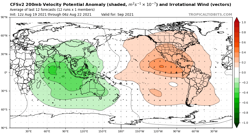
Everything is favoring an extremely favorable late August and September. The convectively-coupled Kelvin wave is forecasted to move across the Atlantic during August and into Africa and the Indian Ocean during September. An above-average West African Monsoon should aid in making the Atlantic very convectively active. Saharan Dust will likely not be a factor in late August and September. Sea surface temperatures are significantly above-average for tropical cyclogenesis both in the tropical North Atlantic and the subtropical North Atlantic, and they are likely to remain this way. In the Pacific, sea surface temperatures are significantly below-average for both the equatorial Pacific and the subtropical North Pacific. For September, a large standing wave over Africa and the Indian Ocean is likely to enhance tropical cyclogenesis in the Atlantic.

At the moment, October and November seem favorable for tropical cyclogenesis. In addition to the warmer-than-average Atlantic and the cooler-than-average Pacific expected for the rest of this year, a mass of rising air over the Indian Ocean and the Maritime Continent should enhance tropical cyclogenesis forecasted by the CanSIPS and the JMA for both October and November.
0 likes   

User avatar
AnnularCane
S2K Supporter
S2K Supporter
Posts: 2862
Joined: Thu Jun 08, 2006 9:18 am
Location: Wytheville, VA

Re: 2021 Indicators: SST's / SAL / MSLP / Shear / Steering / Instability / Sat Images

#2772 Postby AnnularCane » Sun Aug 22, 2021 6:01 pm

Is the MJO typically less of a factor during the peak months?
0 likes   
"But it never rained rain. It never snowed snow. And it never blew just wind. It rained things like soup and juice. It snowed mashed potatoes and green peas. And sometimes the wind blew in storms of hamburgers." -- Judi Barrett, Cloudy with a Chance of Meatballs

User avatar
SFLcane
S2K Supporter
S2K Supporter
Posts: 10163
Age: 47
Joined: Sat Jun 05, 2010 1:44 pm
Location: Lake Worth Florida

Re: 2021 Indicators: SST's / SAL / MSLP / Shear / Steering / Instability / Sat Images

#2773 Postby SFLcane » Sun Aug 22, 2021 6:23 pm

WiscoWx02 wrote:


Noticed that today too.... :eek:
If that verifies than shear won't be a problem for the Atlantic since the sinking cell is right over the eastern Pacific. Before it was showing the sinking cell being more over the central Pacific I do believe, which is why I was hesitant at first. Models are just failing to assimilate this favorable pattern at this point. By then dry air won't be an issue either, so come the second week of September, it'll be go time, not that it hasn't been already but you get what I mean.


Interesting. Question guys..

What's z500 looking like?
0 likes   

User avatar
SFLcane
S2K Supporter
S2K Supporter
Posts: 10163
Age: 47
Joined: Sat Jun 05, 2010 1:44 pm
Location: Lake Worth Florida

Re: 2021 Indicators: SST's / SAL / MSLP / Shear / Steering / Instability / Sat Images

#2774 Postby SFLcane » Sun Aug 22, 2021 7:13 pm

Last edited by SFLcane on Sun Aug 22, 2021 7:14 pm, edited 1 time in total.
3 likes   

User avatar
cycloneye
Admin
Admin
Posts: 145323
Age: 68
Joined: Thu Oct 10, 2002 10:54 am
Location: San Juan, Puerto Rico

Re: 2021 Indicators: SST's / SAL / MSLP / Shear / Steering / Instability / Sat Images

#2775 Postby cycloneye » Sun Aug 22, 2021 7:14 pm

SFLcane wrote:Wow! Unbelievable back tracking :eek:

https://twitter.com/wxpatel/status/142959243944304643


The twit is gone.
0 likes   
Visit the Caribbean-Central America Weather Thread where you can find at first post web cams,radars
and observations from Caribbean basin members Click Here

User avatar
SFLcane
S2K Supporter
S2K Supporter
Posts: 10163
Age: 47
Joined: Sat Jun 05, 2010 1:44 pm
Location: Lake Worth Florida

Re: 2021 Indicators: SST's / SAL / MSLP / Shear / Steering / Instability / Sat Images

#2776 Postby SFLcane » Sun Aug 22, 2021 7:15 pm

cycloneye wrote:
SFLcane wrote:Wow! Unbelievable back tracking :eek:

https://twitter.com/wxpatel/status/142959243944304643


The twit is gone.


Check again
1 likes   

User avatar
toad strangler
S2K Supporter
S2K Supporter
Posts: 4543
Joined: Sun Jul 28, 2013 3:09 pm
Location: Earth
Contact:

Re: 2021 Indicators: SST's / SAL / MSLP / Shear / Steering / Instability / Sat Images

#2777 Postby toad strangler » Sun Aug 22, 2021 7:18 pm

SFLcane wrote:
cycloneye wrote:
SFLcane wrote:Wow! Unbelievable back tracking :eek:

https://twitter.com/wxpatel/status/142959243944304643


The twit is gone.


Check again


Who the hell is that?
0 likes   

User avatar
cycloneye
Admin
Admin
Posts: 145323
Age: 68
Joined: Thu Oct 10, 2002 10:54 am
Location: San Juan, Puerto Rico

Re: 2021 Indicators: SST's / SAL / MSLP / Shear / Steering / Instability / Sat Images

#2778 Postby cycloneye » Sun Aug 22, 2021 7:18 pm

SFLcane wrote:
cycloneye wrote:
SFLcane wrote:Wow! Unbelievable back tracking :eek:

https://twitter.com/wxpatel/status/142959243944304643


The twit is gone.


Check again


Looking at it. Wow.
0 likes   
Visit the Caribbean-Central America Weather Thread where you can find at first post web cams,radars
and observations from Caribbean basin members Click Here

User avatar
Category5Kaiju
Category 5
Category 5
Posts: 4097
Joined: Thu Dec 24, 2020 12:45 pm
Location: Seattle

Re: 2021 Indicators: SST's / SAL / MSLP / Shear / Steering / Instability / Sat Images

#2779 Postby Category5Kaiju » Sun Aug 22, 2021 7:22 pm

While what exactly happens has yet to occur, it's unfortunately looking like September is going to be an ugly time for Atlantic residents. I'm definitely starting to think that the 18-21 NS predictions from many of the forecasting agencies will verify by the end of this season.
0 likes   
Unless explicitly stated, all info in my posts is based on my own opinions and observations. Tropical storms and hurricanes can be extremely dangerous. Do not think you can beat Mother Nature. Refer to an accredited weather research agency or meteorologist if you need to make serious decisions regarding an approaching storm.

User avatar
gatorcane
S2K Supporter
S2K Supporter
Posts: 23691
Age: 47
Joined: Sun Mar 13, 2005 3:54 pm
Location: Boca Raton, FL

Re: 2021 Indicators: SST's / SAL / MSLP / Shear / Steering / Instability / Sat Images

#2780 Postby gatorcane » Sun Aug 22, 2021 7:23 pm

SFLcane wrote:Wow! Unbelievable back tracking :eek:

https://twitter.com/wxpatel/status/1429592439443046403?


Isn’t the fact the shear is dropping typical for this time of year as we head into the peak or is there something different here that is causing concern?
2 likes   


Return to “Talkin' Tropics”

Who is online

Users browsing this forum: jconsor, KeysRedWine, Ulf and 50 guests