2023 Global Model Runs Discussion (Out thru day 16)
Moderator: S2k Moderators
Forum rules

The posts in this forum are NOT official forecasts and should not be used as such. They are just the opinion of the poster and may or may not be backed by sound meteorological data. They are NOT endorsed by any professional institution or STORM2K. For official information, please refer to products from the National Hurricane Center and National Weather Service.
Re: 2023 Global Model Runs Discussion (Out thru day 16)
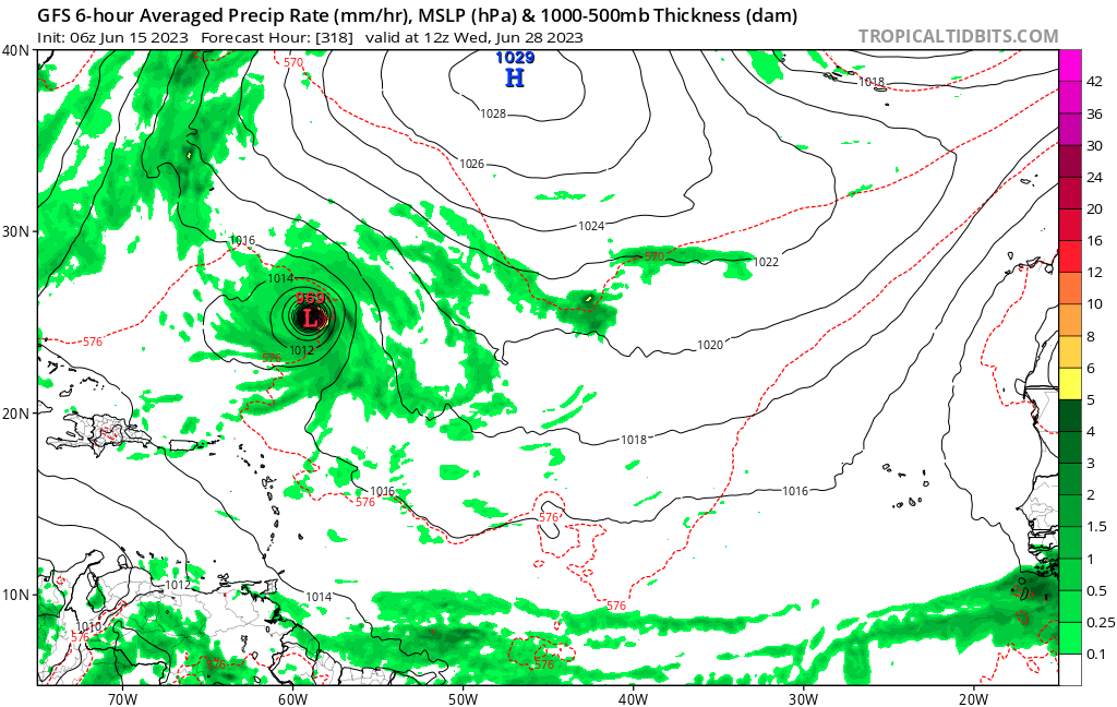
The 0Z GFS is the 30 somethingth run (no longer in a row though) with a W Caribbean TCG within 6/18-20. This run has TCG on 6/18 offshore Nicaragua. It then moves N and and becomes a H before going NNE on 6/22 over W Cuba and as a TS over S FL.
3 likes
Personal Forecast Disclaimer:
The posts in this forum are NOT official forecasts and should not be used as such. They are just the opinion of the poster and may or may not be backed by sound meteorological data. They are NOT endorsed by any professional institution or storm2k.org. For official information, please refer to the NHC and NWS products.
The posts in this forum are NOT official forecasts and should not be used as such. They are just the opinion of the poster and may or may not be backed by sound meteorological data. They are NOT endorsed by any professional institution or storm2k.org. For official information, please refer to the NHC and NWS products.
Re: 2023 Global Model Runs Discussion (Out thru day 16)
The 0Z Euro is the 3rd in a row with a closed tropical low in the MDR east of the LAs. This run has it the furthest south and is slightly stronger than the 12Z.
3 likes
Personal Forecast Disclaimer:
The posts in this forum are NOT official forecasts and should not be used as such. They are just the opinion of the poster and may or may not be backed by sound meteorological data. They are NOT endorsed by any professional institution or storm2k.org. For official information, please refer to the NHC and NWS products.
The posts in this forum are NOT official forecasts and should not be used as such. They are just the opinion of the poster and may or may not be backed by sound meteorological data. They are NOT endorsed by any professional institution or storm2k.org. For official information, please refer to the NHC and NWS products.
-
USTropics
- Professional-Met

- Posts: 2740
- Joined: Sun Aug 12, 2007 3:45 am
- Location: Florida State University
Re: 2023 Global Model Runs Discussion (Out thru day 16)
I noticed there was missing data from NOAA's hurricane track db, so went and filtered ibtracs myself to get a more complete list. Here are some other seasons that had systems form east of the Caribbean and below 20N (with likely TW origins) in the months of June/July:
Hurricane Four from 1887:

Hurricane Three from 1901:

Hurricane Three from 1916:

Hurricane One from 1926:

Hurricane Two from 1933:

Anna 1961:

Hurricane Three from 1964:

Barry 1989:

That gives us a sample size of 23 seasons that featured systems form east of the Caribbean and below 20N going back to 1850. Below is a list of those season's ACE values:
Average ACE is 160.32, and removing the outlier of 2013 from the list gives us 165.97 ACE.
Hurricane Four from 1887:
Hurricane Three from 1901:
Hurricane Three from 1916:
Hurricane One from 1926:
Hurricane Two from 1933:
Anna 1961:
Hurricane Three from 1964:
Barry 1989:
That gives us a sample size of 23 seasons that featured systems form east of the Caribbean and below 20N going back to 1850. Below is a list of those season's ACE values:
Code: Select all
YEAR   ACE
2021   145.7
2020   179.8
2018   132.6
2017   224.9
2013   36.1
2008   145.7
2005   245.3
1998   181.8
1996   166.2
1995   227.1
1990   96.8
1989   135.1
1979   92.9
1969   165.7
1966   145.2
1964   153
1963   112.1
1961   188.9
1933   258.6
1926   229.6
1916   144
1901   99
1887   181.3
Average ACE is 160.32, and removing the outlier of 2013 from the list gives us 165.97 ACE.
7 likes
-
REDHurricane

- Category 1

- Posts: 438
- Age: 28
- Joined: Sun Jul 03, 2022 2:36 pm
- Location: Northeast Pacific Ocean
Re: 2023 Global Model Runs Discussion (Out thru day 16)
Everyone keeps posting about the MDR system down the road, when really we should be talking about the possible comeback of the GFS "phantom" SW Caribbean system everyone was mocking just a few days ago. Look at the similarities between the other models and GFS in the most recent output for 12z Sunday 6/18:
GFS 500mb vort

ECMWF 500mb vort

ICON 500mb vort

Earlier Euro runs showed less pronounced deepening of the system compared to the GFS, but even at the 700mb level the 00z Euro is starting to signal increased vorticity in the same spot just off the east coast of Nicaragua as the GFS is, and had been, showing. Looks like it'll probably come down to exactly how much interaction the system will have with land before it tries to turn to the north:
GFS 700mb vort

ECMWF 700mb vort

Could the GFS have been the light in the darkness all along?!?
GFS 500mb vort
ECMWF 500mb vort
ICON 500mb vort
Earlier Euro runs showed less pronounced deepening of the system compared to the GFS, but even at the 700mb level the 00z Euro is starting to signal increased vorticity in the same spot just off the east coast of Nicaragua as the GFS is, and had been, showing. Looks like it'll probably come down to exactly how much interaction the system will have with land before it tries to turn to the north:
GFS 700mb vort
ECMWF 700mb vort
Could the GFS have been the light in the darkness all along?!?
5 likes

Re: 2023 Global Model Runs Discussion (Out thru day 16)
Euro, ICON, 6Z GFS all have a warm-core genesis around Sunday in the MDR, approximately 10N 40W
0 likes
-
Hypercane_Kyle

- Category 5

- Posts: 3465
- Joined: Sat Mar 07, 2015 7:58 pm
- Location: Cape Canaveral, FL
Re: 2023 Global Model Runs Discussion (Out thru day 16)
06z Euro reminds me of TS Bret in 2017
0 likes
My posts are my own personal opinion, defer to the National Hurricane Center (NHC) and other NOAA products for decision making during hurricane season.
Re: 2023 Global Model Runs Discussion (Out thru day 16)
20% yellow cucumber on the outlook now for the MDR system.
0 likes
-
toad strangler

- S2K Supporter

- Posts: 4546
- Joined: Sun Jul 28, 2013 3:09 pm
- Location: Earth
- Contact:
Re: 2023 Global Model Runs Discussion (Out thru day 16)
BobHarlem wrote:20% yellow cucumber on the outlook now for the MDR system.

2 likes
My Weather Station
https://www.wunderground.com/dashboard/pws/KFLPORTS603
https://www.wunderground.com/dashboard/pws/KFLPORTS603
Re: 2023 Global Model Runs Discussion (Out thru day 16)
Hypercane_Kyle wrote:06z Euro reminds me of TS Bret in 2017
I know you meant 0Z Euro. That run has a TD that looks close to making minimal TS strength as Bret (assuming 0Z GFS is wrong about its earlier W Caribbean system) that as you said is similar to Bret of 2017. If that occurs, Bret of 2023 would be second only to Bret of 2017 as the earliest TS on record to go into the Caribbean from the east.
0 likes
Personal Forecast Disclaimer:
The posts in this forum are NOT official forecasts and should not be used as such. They are just the opinion of the poster and may or may not be backed by sound meteorological data. They are NOT endorsed by any professional institution or storm2k.org. For official information, please refer to the NHC and NWS products.
The posts in this forum are NOT official forecasts and should not be used as such. They are just the opinion of the poster and may or may not be backed by sound meteorological data. They are NOT endorsed by any professional institution or storm2k.org. For official information, please refer to the NHC and NWS products.
-
JetFuel_SE

- Category 1
- Posts: 288
- Age: 26
- Joined: Thu Apr 30, 2020 3:57 pm
Re: 2023 Global Model Runs Discussion (Out thru day 16)
06z GFS is on something special it seems.

Peak

Peak
6 likes
-
SFLcane

- S2K Supporter
- Posts: 10281
- Age: 48
- Joined: Sat Jun 05, 2010 1:44 pm
- Location: Lake Worth Florida
Re: 2023 Global Model Runs Discussion (Out thru day 16)
SFLcane wrote:Hi guys, trying to get Luis reinstated. He will be back soon.
tolakram If you see this check your messages.
Can someone unlock Luis? He is waiting.
Thanks!
1 likes
-
Ivanhater

- Storm2k Moderator

- Posts: 11222
- Age: 39
- Joined: Fri Jul 01, 2005 8:25 am
- Location: Pensacola
Re: 2023 Global Model Runs Discussion (Out thru day 16)
SFLcane wrote:SFLcane wrote:Hi guys, trying to get Luis reinstated. He will be back soon.
tolakram If you see this check your messages.
Can someone unlock Luis? He is waiting.
Thanks!
Not sure what happened but I tried "forced reactivation" Let me know if that works
0 likes
Michael
-
Ivanhater
- Storm2k Moderator
- Posts: 11222
- Age: 39
- Joined: Fri Jul 01, 2005 8:25 am
- Location: Pensacola
Re: 2023 Global Model Runs Discussion (Out thru day 16)
Think I have Luis activated again.
4 likes
Michael
-
wxman57

- Moderator-Pro Met

- Posts: 23175
- Age: 68
- Joined: Sat Jun 21, 2003 8:06 pm
- Location: Houston, TX (southwest)
Re: 2023 Global Model Runs Discussion (Out thru day 16)
Looks like there may be a fair chance that the disturbance just moving offshore Africa will develop into a weak TS prior to nearing the NE Caribbean next Thu/Fri. I'd say maybe 70%-80% chance of at least some development within 7 days, given the good model agreement. None of the models indicates anything strong, and all indicate very weak or nonexistent ridging to the north, which should allow for a northward turn near the NE Caribbean. There doesn't appear to be any steering flow that could keep it moving west through the Caribbean and toward the Gulf or toward the East U.S. Coast. Something to keep an eye on.
2 likes
-
SFLcane
- S2K Supporter
- Posts: 10281
- Age: 48
- Joined: Sat Jun 05, 2010 1:44 pm
- Location: Lake Worth Florida
Re: 2023 Global Model Runs Discussion (Out thru day 16)
wxman57 wrote:Looks like there may be a fair chance that the disturbance just moving offshore Africa will develop into a weak TS prior to nearing the NE Caribbean next Thu/Fri. I'd say maybe 70%-80% chance of at least some development within 7 days, given the good model agreement. None of the models indicates anything strong, and all indicate very weak or nonexistent ridging to the north, which should allow for a northward turn near the NE Caribbean. There doesn't appear to be any steering flow that could keep it moving west through the Caribbean and toward the Gulf or toward the East U.S. Coast. Something to keep an eye on.

4 likes
-
SFLcane
- S2K Supporter
- Posts: 10281
- Age: 48
- Joined: Sat Jun 05, 2010 1:44 pm
- Location: Lake Worth Florida
Re: 2023 Global Model Runs Discussion (Out thru day 16)
Ivanhater wrote:Think I have Luis activated again.
Did not work apparantly.
0 likes
-
wxman57
- Moderator-Pro Met
- Posts: 23175
- Age: 68
- Joined: Sat Jun 21, 2003 8:06 pm
- Location: Houston, TX (southwest)
Re: 2023 Global Model Runs Discussion (Out thru day 16)
SFLcane wrote:wxman57 wrote:Looks like there may be a fair chance that the disturbance just moving offshore Africa will develop into a weak TS prior to nearing the NE Caribbean next Thu/Fri. I'd say maybe 70%-80% chance of at least some development within 7 days, given the good model agreement. None of the models indicates anything strong, and all indicate very weak or nonexistent ridging to the north, which should allow for a northward turn near the NE Caribbean. There doesn't appear to be any steering flow that could keep it moving west through the Caribbean and toward the Gulf or toward the East U.S. Coast. Something to keep an eye on.
Nothing strong passing the NE Caribbean. You believing the long-range GFS again? How's that west Caribbean/Gulf hurricane forecast working out? GFS develops everything into a strong cyclone, worldwide.
5 likes


Re: 2023 Global Model Runs Discussion (Out thru day 16)
In observing the models recently, it seems the CMC's name has changed from Constantly Making Cyclones to Can't Make Cyclones.
7 likes
-
SFLcane
- S2K Supporter
- Posts: 10281
- Age: 48
- Joined: Sat Jun 05, 2010 1:44 pm
- Location: Lake Worth Florida
Re: 2023 Global Model Runs Discussion (Out thru day 16)
wxman57 wrote:SFLcane wrote:wxman57 wrote:Looks like there may be a fair chance that the disturbance just moving offshore Africa will develop into a weak TS prior to nearing the NE Caribbean next Thu/Fri. I'd say maybe 70%-80% chance of at least some development within 7 days, given the good model agreement. None of the models indicates anything strong, and all indicate very weak or nonexistent ridging to the north, which should allow for a northward turn near the NE Caribbean. There doesn't appear to be any steering flow that could keep it moving west through the Caribbean and toward the Gulf or toward the East U.S. Coast. Something to keep an eye on.
Nothing strong passing the NE Caribbean. You believing the long-range GFS again? How's that west Caribbean/Gulf hurricane forecast working out? GFS develops everything into a strong cyclone, worldwide.
Garbage model.. Spins up a TC quickly in six hours due to extreme convection. Typical bias this time of the year.
1 likes
Re: 2023 Global Model Runs Discussion (Out thru day 16)
12z gfs is back to development in the west Caribbean. I still don't believe it, but we're talking 5 days out now, and a sw florida hit just under a week. Why does it do this? Quit being a punk.
3 likes
Who is online
Users browsing this forum: Hurricane2022, Ulf and 132 guests