Possible development in the Western Atlantic / GOM (Is Invest 97L)

This is the general tropical discussion area. Anyone can take their shot at predicting a storms path.

Moderator: S2k Moderators

Forum rules

The posts in this forum are NOT official forecasts and should not be used as such. They are just the opinion of the poster and may or may not be backed by sound meteorological data. They are NOT endorsed by any professional institution or STORM2K. For official information, please refer to products from the National Hurricane Center and National Weather Service.

Help Support Storm2K
Message
Author
BobHarlem
Category 5
Category 5
Posts: 2105
Joined: Thu Oct 20, 2005 6:11 pm

Re: Possible development in the central Atlantic (0/60)

#281 Postby BobHarlem » Tue Jul 30, 2024 7:03 am

boca wrote:
GCANE wrote:Strong Omega Block forecast over mid Conus.
Looking more likely for a GOM TC


I don’t think the NHC agrees with the omega block looks like they are siding with the Euro,Icon and CMC. At least at the 8am update.


Euro at the ilk is at least a lot more consistent, even though 0z euro shifted into Florida some. NHC will usually prefer persistence. (Beryl not withstanding)

At some point the NHC may have to put up PTC advisories because it's going to be so slow to initially get developed, then I'd expect to see lots of mentions about low confidence. There's still probably not enough for an invest with the wave. This is just going to be a pita to forecast until it develops, and when it does it'll get really interesting. If you split the difference between the GFS/Euro you wind up with a ton of flooding rain somewhere in FL/GA/SC, kinda ironic because of all the dry air around it now.
Last edited by BobHarlem on Tue Jul 30, 2024 8:01 am, edited 7 times in total.
1 likes   

User avatar
toad strangler
S2K Supporter
S2K Supporter
Posts: 4543
Joined: Sun Jul 28, 2013 3:09 pm
Location: Earth
Contact:

Re: Possible development in the central Atlantic (0/60)

#282 Postby toad strangler » Tue Jul 30, 2024 7:04 am

boca wrote:
GCANE wrote:Strong Omega Block forecast over mid Conus.
Looking more likely for a GOM TC


I don’t think the NHC agrees with the omega block looks like they are siding with the Euro,Icon and CMC. At least at the 8am update.


...and nudged that possible development region even more east.
0 likes   

User avatar
Blown Away
S2K Supporter
S2K Supporter
Posts: 10145
Joined: Wed May 26, 2004 6:17 am

Re: Possible development in the central Atlantic (0/60)

#283 Postby Blown Away » Tue Jul 30, 2024 7:13 am

Image
8am NHC "X" position was @15N/52W. There is a swirl there but little convection.
0 likes   
Hurricane Eye Experience: David 79, Irene 99, Frances 04, Jeanne 04, Wilma 05... EYE COMING MY WAY IN 2024…
Hurricane Brush Experience: Andrew 92, Erin 95, Floyd 99, Matthew 16, Irma 17, Ian 22, Nicole 22…

User avatar
REDHurricane
Category 1
Category 1
Posts: 396
Age: 27
Joined: Sun Jul 03, 2022 2:36 pm
Location: Northeast Pacific Ocean

Re: Possible development in the central Atlantic (0/60)

#284 Postby REDHurricane » Tue Jul 30, 2024 7:18 am

EPS 00z
Image

GEFS 00z
Image

Canadian ensemble seems to be right down the middle between the two, so basically we're no closer to figuring out what's going to happen with this system than we were 4-5 days ago... gotta love the seasonal pattern switch shenanigans! Regardless, even if this doesn't develop into anything significant it will certainly set the stage for whatever comes over the next few weeks by helping to eat up all that dry air
0 likes   

LarryWx
S2K Supporter
S2K Supporter
Posts: 6304
Joined: Sun Sep 07, 2003 2:04 pm
Location: GA

Re: Possible development in the central Atlantic (0/60)

#285 Postby LarryWx » Tue Jul 30, 2024 7:32 am

1. 6Z ICON 120!similar to 0Z’s 126.
2. 6Z EPS 144 mean a little W of 0Z 150 possibly implying a little higher risk to NC when projecting ahead
0 likes   
Personal Forecast Disclaimer:
The posts in this forum are NOT official forecasts and should not be used as such. They are just the opinion of the poster and may or may not be backed by sound meteorological data. They are NOT endorsed by any professional institution or storm2k.org. For official information, please refer to the NHC and NWS products.

User avatar
WaveBreaking
Category 2
Category 2
Posts: 578
Joined: Sun Jun 30, 2024 11:33 am
Location: US

Re: Possible development in the central Atlantic (0/60)

#286 Postby WaveBreaking » Tue Jul 30, 2024 7:38 am

Every OP model except the GFS is showing an OTS path this morning. GFS now has it stalling in the N GOM until suddenly veering W and striking Texas as a strong TS/H1.
Last edited by WaveBreaking on Tue Jul 30, 2024 7:40 am, edited 1 time in total.
0 likes   
I am NOT a professional meteorologist, so take all of my posts with a grain of salt. My opinions are mine and mine alone.

User avatar
wxman57
Moderator-Pro Met
Moderator-Pro Met
Posts: 22978
Age: 67
Joined: Sat Jun 21, 2003 8:06 pm
Location: Houston, TX (southwest)

Re: Possible development in the central Atlantic (0/60)

#287 Postby wxman57 » Tue Jul 30, 2024 7:39 am

It seems apparent that earlier development favors a northward turn near Florida and/or the Bahamas. It catches the connection with the upper trof along the east coast if it develops Sat/Sun. Later development (GFS) may mean it will not see the weakness in the ridge and continue westward across the Gulf. We really won't be very confident in its track until it begins to show signs of organization - maybe Friday or Saturday.
10 likes   

User avatar
cycloneye
Admin
Admin
Posts: 145296
Age: 68
Joined: Thu Oct 10, 2002 10:54 am
Location: San Juan, Puerto Rico

Re: Possible development in the central Atlantic (0/60)

#288 Postby cycloneye » Tue Jul 30, 2024 7:54 am

Dry big wave.

Image
0 likes   
Visit the Caribbean-Central America Weather Thread where you can find at first post web cams,radars
and observations from Caribbean basin members Click Here

User avatar
tropicwatch
Category 5
Category 5
Posts: 3383
Age: 61
Joined: Sat Jun 02, 2007 10:01 am
Location: Panama City Florida
Contact:

Re: Possible development in the central Atlantic (0/60)

#289 Postby tropicwatch » Tue Jul 30, 2024 7:57 am

cycloneye wrote:Dry big wave.

https://i.imgur.com/Ygsf0Gm.gif

From the latest TWO it appears that is the one the NHC is focusing on.
0 likes   
Tropicwatch


Agnes 72', Eloise 75, Elena 85', Kate 85', Charley 86', Florence 88', Beryl 94', Dean 95', Erin 95', Opal 95', Earl 98', Georges 98', Ivan 2004', Arlene 2005', Dennis 2005', Ida 2009' Debby 2012' Irma 2017' Michael 2018'

User avatar
GCANE
S2K Supporter
S2K Supporter
Posts: 11496
Joined: Mon Oct 22, 2007 8:03 am

Re: Possible development in the central Atlantic (0/60)

#290 Postby GCANE » Tue Jul 30, 2024 8:04 am

boca wrote:
GCANE wrote:Strong Omega Block forecast over mid Conus.
Looking more likely for a GOM TC


I don’t think the NHC agrees with the omega block looks like they are siding with the Euro,Icon and CMC. At least at the 8am update.

2 runs in a row for GFS. Maybe they will change their minds later today.
0 likes   

User avatar
SFLcane
S2K Supporter
S2K Supporter
Posts: 10163
Age: 47
Joined: Sat Jun 05, 2010 1:44 pm
Location: Lake Worth Florida

Re: Possible development in the central Atlantic (0/60)

#291 Postby SFLcane » Tue Jul 30, 2024 8:05 am

1 likes   

User avatar
GCANE
S2K Supporter
S2K Supporter
Posts: 11496
Joined: Mon Oct 22, 2007 8:03 am

Re: Possible development in the central Atlantic (0/60)

#292 Postby GCANE » Tue Jul 30, 2024 8:08 am

A huge dry wave and CONUS Omega Block has GOM written all over it.
1 likes   

User avatar
JaxGator
Category 2
Category 2
Posts: 780
Joined: Sun Jun 12, 2016 3:33 pm
Location: Jacksonville Florida

Re: Possible development in the central Atlantic (0/60)

#293 Postby JaxGator » Tue Jul 30, 2024 8:26 am

N2FSU wrote:Another look at the 0z UKMET and it’s significant west shift into the Gulf:

https://uploads.tapatalk-cdn.com/20240730/0a1cfed9eb0ed47528288ec9c624e8c3.jpg


Sent from my iPad using Tapatalk


*IF* that scenario would pan out, all or most of the Florida peninsula on the eastern side. Usually depending on the size and strength of the tropical cyclone, the peninsula won’t escape any effects, be it rain, wind or tornadoes. This potential Debby if it does get close to Florida, it will be on my birthday weekend. While it’ll be cool to track “potential” Debby, I rather not have the storm hit anybody (be it Gulf Coast or the East Coast) or ruin any birthday plans.

In the mean time, we still need a center of circulation for the models to latch on too (spin is definitely evident now). Upper air data from Recon would be most welcome. Hope y’all are doing well this week and in general. Praying this hurricane season won’t be bad as it already has been for folks in the Caribbean and Texas.
0 likes   
The posts or stuff said are NOT an official forecast. Please look to the NHC and NWS for official forecasts and products.

Floyd-1999, Frances-2004, Jeanne-2004, Fay-2008, Beryl-2012, Debby-2012, Colin-2016, Hermine-2016, Julia-2016, Matthew-2016, Irma-2017, Elsa-2021, Idalia-2023, Debby-2024, Helene-2024.


Go Gators! Go Jags!

User avatar
boca
Category 5
Category 5
Posts: 6367
Age: 60
Joined: Mon Dec 15, 2003 8:49 am
Location: Boca Raton,FL

Re: Possible development in the central Atlantic (0/60)

#294 Postby boca » Tue Jul 30, 2024 8:33 am

GCANE wrote:A huge dry wave and CONUS Omega Block has GOM written all over it.


I always enjoy reading your posts and why do you think the Euro and the other models other than the GFS insist on the turn.The weakness is that supposed to fill in or be weaker?
1 likes   

User avatar
toad strangler
S2K Supporter
S2K Supporter
Posts: 4543
Joined: Sun Jul 28, 2013 3:09 pm
Location: Earth
Contact:

Re: Possible development in the central Atlantic (0/60)

#295 Postby toad strangler » Tue Jul 30, 2024 8:52 am

No mention of the GFS outliers in Michael Lowry's update today.

MICHAEL LOWRY
JUL 30

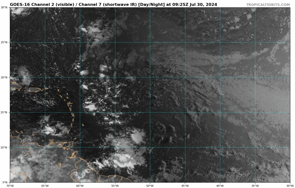
We continue to follow a large tropical wave moving toward the easternmost Caribbean islands with little fanfare. The disturbance – a ripple in the atmospheric winds about 10,000 feet up resembling an ocean wave – is mostly dry and absent any significant weather for now but is expected to fire off rounds of storminess beginning tomorrow, which could allow it to develop as it approaches the Bahamas and Florida on Friday into the weekend. The National Hurricane Center is indicating a tropical depression may form by late week as the system is nearing the Bahamas. While squally weather with gusty winds and occasional downpours may accompany the system’s passage through the northeastern Caribbean tomorrow and Thursday, a significant tropical threat isn’t expected in these areas.

Possible development near the Bahamas by Friday. It’s not until the system is nearing the Bahamas on Friday that development becomes a little more likely. Even so, forecast models continue to show modest southerly wind shear nearby from an upper-level high positioned east of the system. This should serve as a speed bump to quick development despite the very warm waters east of Florida. An area of high pressure aloft, situated just east of the developing system by late Friday, could impart modest wind shear across the system, slowing development. This is reflected in our computer models, which largely depict a strong tropical wave, tropical depression, or perhaps low-end tropical storm (Debby) into the weekend.

The positioning of the upper-level high is critical as to how much development happens by this weekend. A more westward-oriented high pressure situated near or over the developing system would allow for further organization, though it’s worth noting at this stage none of our guidance shows the threat of a strong system. By Friday a dip in the jet stream digging into the central U.S. will help to bend the system northward around the western periphery of the subtropical high-pressure steering. The question is not whether it bends but where it bends. The good news for Florida is a stronger, more organized system would feel the tug of the higher jet stream winds sooner and favor a turn farther east. A weaker system would probably head farther west, perhaps affecting the peninsula or even sliding into the eastern Gulf this weekend.

The bottom line this week we expect a tropical depression or low-end tropical storm could form by the end of the work week as it nears the Bahamas. A weaker system would tend to favor a more westward trajectory near or over Florida, while a stronger, more organized system would tend to bend northward farther east. A lot will depend on where the center of the large and still-disorganized disturbance ultimately forms, which we won’t know for at least another few days. Given the time of year and development timeline closer to land, interests from the Bahamas to the southeastern U.S. – including folks in Florida, southeast Georgia, and the Carolinas – should monitor the progress of this system this week.
0 likes   

User avatar
MGC
S2K Supporter
S2K Supporter
Posts: 5899
Joined: Sun Mar 23, 2003 9:05 pm
Location: Pass Christian MS, or what is left.

Re: Possible development in the central Atlantic (0/60)

#296 Postby MGC » Tue Jul 30, 2024 9:14 am

IMO the key to which model verifies will be determined on how quickly the wave develops sufficient moisture. Wave is bone dry and is embedded in a large area of SAL. Both areas are moving westward in tandem. At this point I am taking all model output with a grain of salt. Guess we are just going to have to wait and see how and when the wave moisten up. Dryer wave further west, moist wave recurves around Florida?.......MGC
0 likes   

User avatar
GCANE
S2K Supporter
S2K Supporter
Posts: 11496
Joined: Mon Oct 22, 2007 8:03 am

Re: Possible development in the central Atlantic (0/60)

#297 Postby GCANE » Tue Jul 30, 2024 9:33 am

boca wrote:
GCANE wrote:A huge dry wave and CONUS Omega Block has GOM written all over it.


I always enjoy reading your posts and why do you think the Euro and the other models other than the GFS insist on the turn.The weakness is that supposed to fill in or be weaker?


I always follow GFS for large synoptic forecasts such as the Jet Stream, aka Rossby Waves.
It is much more reliable then the other models IMHO
0 likes   

Michele B
S2K Supporter
S2K Supporter
Posts: 1114
Joined: Thu Aug 25, 2016 8:08 am
Location: SWFL

Re: Possible development in the central Atlantic (0/60)

#298 Postby Michele B » Tue Jul 30, 2024 9:40 am

BobHarlem wrote:Very large/broad spin on Satellite now, this will take a while to get organized.

https://i.imgur.com/Qz9mpS9.gif

Model runs this morning are a real head scratcher though.


But what is happening up around 26N and 59W? Something forming up there??
0 likes   
Cleo - 1964, Betsy - 1965, David - 1979, Andrew - 1992, Charlie (Francis, Ivan, Jeanne) - 2004, Irma - 2017, Ian - 2022

User avatar
Spacecoast
Category 2
Category 2
Posts: 758
Joined: Thu Aug 31, 2017 2:03 pm

Re: Possible development in the central Atlantic (0/60)

#299 Postby Spacecoast » Tue Jul 30, 2024 9:41 am

EC-AI does a little loop. ....
Image
0 likes   

User avatar
cycloneye
Admin
Admin
Posts: 145296
Age: 68
Joined: Thu Oct 10, 2002 10:54 am
Location: San Juan, Puerto Rico

Re: Possible development in the central Atlantic (0/60)

#300 Postby cycloneye » Tue Jul 30, 2024 10:11 am

The squadron folks keep pushing back the first mission because the cyclogenesis also keeps going back in time. It was going to be today but yesterday they pushed it to wednesday, and now is for thursday.

Image
0 likes   
Visit the Caribbean-Central America Weather Thread where you can find at first post web cams,radars
and observations from Caribbean basin members Click Here


Return to “Talkin' Tropics”

Who is online

Users browsing this forum: Stormybajan, Teban54, Ulf and 39 guests