Tropical Wave in Bay of Campeche (Is Invest 91L)

This is the general tropical discussion area. Anyone can take their shot at predicting a storms path.

Moderator: S2k Moderators

Forum rules

The posts in this forum are NOT official forecasts and should not be used as such. They are just the opinion of the poster and may or may not be backed by sound meteorological data. They are NOT endorsed by any professional institution or STORM2K. For official information, please refer to products from the National Hurricane Center and National Weather Service.

Help Support Storm2K
Message
Author
Weathertracker96
Tropical Storm
Tropical Storm
Posts: 104
Joined: Mon Oct 16, 2023 3:41 pm

Re: Tropical Wave in Central Atlantic (0/40)

#281 Postby Weathertracker96 » Thu Aug 29, 2024 4:51 pm

Ivanhater wrote:The same conditions that are causing the MDR to be suppressed looks to also be the reason Florida and the Gulf are in increasing danger of a major hurricane in a week or so :double:


Can you expand on this and explain what players this affects that might make this a Fl & Gulf possible threat?

You can private message me if it’s easier
0 likes   

User avatar
beachnut
S2K Supporter
S2K Supporter
Posts: 62
Joined: Wed Aug 31, 2016 6:44 pm
Location: SW Cape Coral. FL

Re: Tropical Wave in Central Atlantic (0/40)

#282 Postby beachnut » Thu Aug 29, 2024 4:53 pm

DunedinDave wrote:That Euro track is giving me Ian memories.


We don't like Ian memories!

PS. We used to live in Dunedin back in the 80's
1 likes   
Elena '85 - Charley '04 - Wilma '05 - Irma '17 - Ian '22

User avatar
Ivanhater
Storm2k Moderator
Storm2k Moderator
Posts: 11153
Age: 38
Joined: Fri Jul 01, 2005 8:25 am
Location: Pensacola

Re: Tropical Wave in Central Atlantic (0/40)

#283 Postby Ivanhater » Thu Aug 29, 2024 5:04 pm

Weathertracker96 wrote:
Ivanhater wrote:The same conditions that are causing the MDR to be suppressed looks to also be the reason Florida and the Gulf are in increasing danger of a major hurricane in a week or so :double:


Can you expand on this and explain what players this affects that might make this a Fl & Gulf possible threat?

You can private message me if it’s easier


I mentioned this a few days ago when the Ensembles were split. The ones that developed before the Caribbean were showing a clear escape well east of the US. The ones showing a delayed development until the Western Caribbean are showing a dangerous setup for Florida and the Gulf.

The delayed development is becoming increasingly likely which is not good for the US
1 likes   
Michael

BobHarlem
Category 5
Category 5
Posts: 2034
Joined: Thu Oct 20, 2005 6:11 pm

Re: Tropical Wave in Central Atlantic (0/40)

#284 Postby BobHarlem » Thu Aug 29, 2024 5:07 pm

only 105 hours so far, but the 18z gfs has the vorticity back, a bit stronger than the 6z and a bit further south. (12z had nada)
0 likes   

Weathertracker96
Tropical Storm
Tropical Storm
Posts: 104
Joined: Mon Oct 16, 2023 3:41 pm

Re: Tropical Wave in Central Atlantic (0/40)

#285 Postby Weathertracker96 » Thu Aug 29, 2024 5:12 pm

Ivanhater wrote:
Weathertracker96 wrote:
Ivanhater wrote:The same conditions that are causing the MDR to be suppressed looks to also be the reason Florida and the Gulf are in increasing danger of a major hurricane in a week or so :double:


Can you expand on this and explain what players this affects that might make this a Fl & Gulf possible threat?

You can private message me if it’s easier


I mentioned this a few days ago when the Ensembles were split. The ones that developed before the Caribbean were showing a clear escape well east of the US. The ones showing a delayed development until the Western Caribbean are showing a dangerous setup for Florida and the Gulf.

The delayed development is becoming increasingly likely which is not good for the US


Thanks for answering. Yes, it’s looking like delayed development may be the solution for now. That is a dangerous one too because we all know how storms can over perform in Caribbean/ gulf
0 likes   

LAF92
Tropical Depression
Tropical Depression
Posts: 51
Joined: Fri Aug 18, 2023 6:27 pm

Re: Tropical Wave in Central Atlantic (0/40)

#286 Postby LAF92 » Thu Aug 29, 2024 5:25 pm

18z GFS back to some development thru 160 hours it’s showing a strengthening TW heading into the Caribbean
1 likes   

User avatar
toad strangler
S2K Supporter
S2K Supporter
Posts: 4543
Joined: Sun Jul 28, 2013 3:09 pm
Location: Earth
Contact:

Re: Tropical Wave in Central Atlantic (0/40)

#287 Postby toad strangler » Thu Aug 29, 2024 5:39 pm

18z GFS ramping up in the western Caribbean @234 heading into the GOM
2 likes   

Keldeo1997
Category 2
Category 2
Posts: 637
Joined: Fri Oct 11, 2019 11:35 pm

Re: Tropical Wave in Central Atlantic (0/40)

#288 Postby Keldeo1997 » Thu Aug 29, 2024 5:45 pm

This run looks like its going to be Classic Happy hour GFS
0 likes   

LAF92
Tropical Depression
Tropical Depression
Posts: 51
Joined: Fri Aug 18, 2023 6:27 pm

Re: Tropical Wave in Central Atlantic (0/40)

#289 Postby LAF92 » Thu Aug 29, 2024 5:47 pm

toad strangler wrote:18z GFS ramping up in the western Caribbean @234 heading into the GOM

Shooting the gap not going to be a pretty run for the gulf coast
0 likes   

BobHarlem
Category 5
Category 5
Posts: 2034
Joined: Thu Oct 20, 2005 6:11 pm

Re: Tropical Wave in Central Atlantic (0/40)

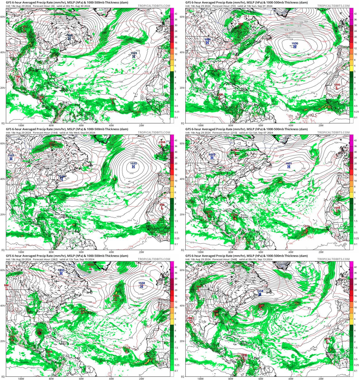
#290 Postby BobHarlem » Thu Aug 29, 2024 6:00 pm

Image
1 likes   

User avatar
Category5Kaiju
Category 5
Category 5
Posts: 4051
Joined: Thu Dec 24, 2020 12:45 pm
Location: Seattle

Re: Tropical Wave in Central Atlantic (0/40)

#291 Postby Category5Kaiju » Thu Aug 29, 2024 6:02 pm

Looks like it's about to hit the Mississippi/Alabama Gulf Coast per the latest GFS operational.
1 likes   
Unless explicitly stated, all info in my posts is based on my own opinions and observations. Tropical storms and hurricanes can be extremely dangerous. Do not think you can beat Mother Nature. Refer to an accredited weather research agency or meteorologist if you need to make serious decisions regarding an approaching storm.

IcyTundra
Category 5
Category 5
Posts: 1205
Joined: Mon Jun 07, 2021 9:32 pm
Location: Dickinson, Texas

Re: Tropical Wave in Central Atlantic (0/40)

#292 Postby IcyTundra » Thu Aug 29, 2024 6:05 pm

Category5Kaiju wrote:Looks like it's about to hit the Mississippi/Alabama Gulf Coast per the latest GFS operational.


Yes looks like MS/AL border this run.
0 likes   

User avatar
Ivanhater
Storm2k Moderator
Storm2k Moderator
Posts: 11153
Age: 38
Joined: Fri Jul 01, 2005 8:25 am
Location: Pensacola

Re: Tropical Wave in Central Atlantic (0/40)

#293 Postby Ivanhater » Thu Aug 29, 2024 6:06 pm

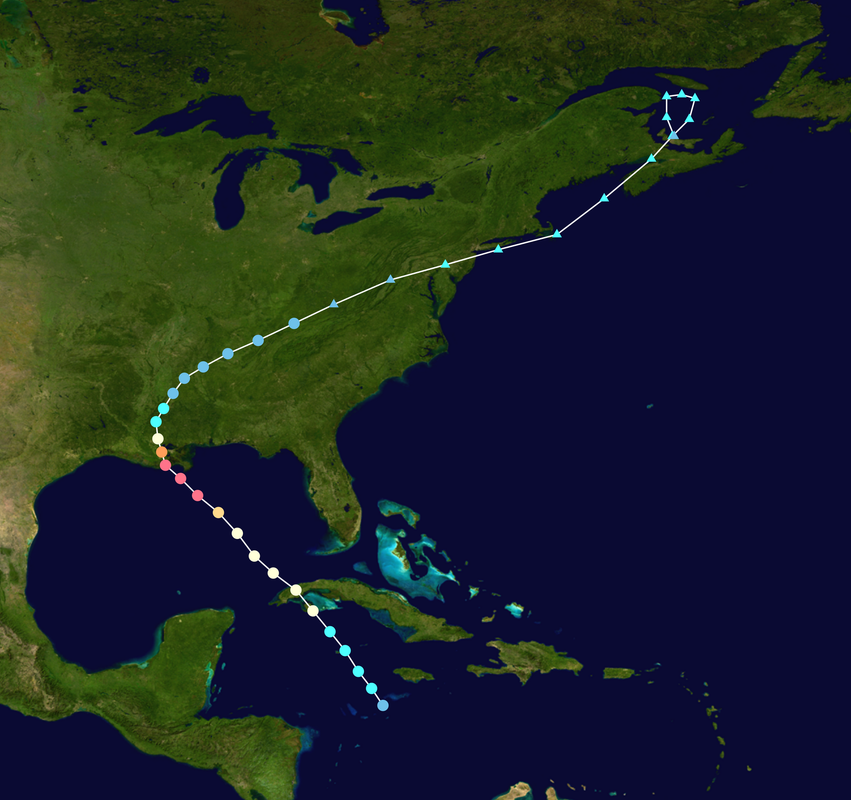
Ouch

Image

Sent from my motorola razr plus 2023 using Tapatalk
1 likes   
Michael

User avatar
Teban54
Category 5
Category 5
Posts: 3168
Joined: Sat May 19, 2018 1:19 pm

Re: Tropical Wave in Central Atlantic (0/40)

#294 Postby Teban54 » Thu Aug 29, 2024 6:15 pm

While it's very unlikely to verify exactly like this, 18z GFS is basically Ida 2.0 except for US landfall location. Genesis and early evolution are strikingly similar.

Delayed development, which 12z Euro and 18z GFS are showing, is not your friend...

(Why development is delayed on 18z compared to 0z and 6z is another matter, and it feels weird to me as 18z has the vorticity just as organized as the earlier developing runs entering the Caribbean. Is it shear, land interaction, influences of GFS's South American vorticity, or something else?)

Image

Image
1 likes   

User avatar
blp
Category 5
Category 5
Posts: 2840
Age: 46
Joined: Thu Sep 09, 2004 7:51 pm
Location: Miami, FL
Contact:

Re: Tropical Wave in Central Atlantic (0/40)

#295 Postby blp » Thu Aug 29, 2024 6:29 pm

Kudos to the ICON and CMC for sniffing this out early. If I am not mistaken they too did well with Beryl. They may not be the best for track but they are certainly serving their purpose for cyclogenesis at this moment.
1 likes   
The following post is NOT an official forecast and should not be used as such. It is just the opinion of the poster and may or may not be backed by sound meteorological data. It is NOT endorsed by any professional institution including storm2k.org For Official Information please refer to the NHC and NWS products.

User avatar
Category5Kaiju
Category 5
Category 5
Posts: 4051
Joined: Thu Dec 24, 2020 12:45 pm
Location: Seattle

Re: Tropical Wave in Central Atlantic (0/40)

#296 Postby Category5Kaiju » Thu Aug 29, 2024 6:36 pm

blp wrote:Kudos to the ICON and CMC for sniffing this out early. If I am not mistaken they too did well with Beryl. They may not be the best for track but they are certainly serving their purpose for cyclogenesis at this moment.


Euro ensembles too. The Euro ensembles have been pretty unwavering with this system forming while the GEFS ensembles greatly (and falsely) saw their support for the system diminish at one point.
1 likes   
Unless explicitly stated, all info in my posts is based on my own opinions and observations. Tropical storms and hurricanes can be extremely dangerous. Do not think you can beat Mother Nature. Refer to an accredited weather research agency or meteorologist if you need to make serious decisions regarding an approaching storm.

User avatar
DorkyMcDorkface
Category 3
Category 3
Posts: 821
Age: 27
Joined: Mon Sep 30, 2019 1:32 pm
Location: Mid-Atlantic

Re: Tropical Wave in Central Atlantic (0/40)

#297 Postby DorkyMcDorkface » Thu Aug 29, 2024 6:40 pm

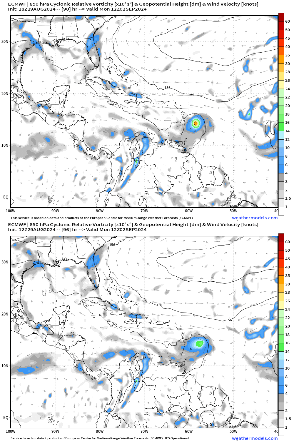
18z Euro came in stronger:
Image
4 likes   
Please note the thougths expressed by this account are solely those of the user and are from a hobbyist perspective. For more comprehensive analysis, consult an actual professional meteorologist or meteorology agency.


Floyd 1999 | Isabel 2003 | Hanna 2008 | Irene 2011 | Sandy 2012 | Isaias 2020

User avatar
cycloneye
Admin
Admin
Posts: 143867
Age: 68
Joined: Thu Oct 10, 2002 10:54 am
Location: San Juan, Puerto Rico

Re: Tropical Wave in Central Atlantic (10/50)

#298 Postby cycloneye » Thu Aug 29, 2024 6:46 pm

Central Tropical Atlantic:
A tropical wave over the central Tropical Atlantic continues to
produce disorganized showers and thunderstorms that have become a
little more concentrated near its axis. Environmental conditions
appear conducive for gradual development of this system, and a
tropical depression could form by early next week while it moves
westward at 10 to 15 mph, approaching the Lesser Antilles. The
system is then forecast to continue moving westward to
west-northwestward across portions of the eastern and central
Caribbean Sea by the middle part of next week.
* Formation chance through 48 hours...low...10 percent.
* Formation chance through 7 days...medium...50 percent.


Image
6 likes   
Visit the Caribbean-Central America Weather Thread where you can find at first post web cams,radars
and observations from Caribbean basin members Click Here

User avatar
Nimbus
Category 5
Category 5
Posts: 5274
Joined: Mon Jul 19, 2004 10:54 am

Re: Tropical Wave in Central Atlantic (10/50)

#299 Postby Nimbus » Thu Aug 29, 2024 6:53 pm

Up to 50% and the GFS is tracking through the Yucatan channel.
Its getting harder and harder to imagine a good outcome without a hostile TUTT in the forecast to provide shear.
1 likes   

User avatar
Hammy
Category 5
Category 5
Posts: 5849
Age: 41
Joined: Fri May 25, 2012 5:25 pm
Contact:

Re: Tropical Wave in Central Atlantic (0/40)

#300 Postby Hammy » Thu Aug 29, 2024 6:53 pm

blp wrote:Kudos to the ICON and CMC for sniffing this out early. If I am not mistaken they too did well with Beryl. They may not be the best for track but they are certainly serving their purpose for cyclogenesis at this moment.


Hasn't the ICON been sniffing out storm after storm over the last few weeks that didn't develop though?
0 likes   
The above post is not official and should not be used as such. It is the opinion of the poster and may or may not be backed by sound meteorological data. It is not endorsed by any professional institution or storm2k.org. For official information, please refer to the NHC and NWS products.


Return to “Talkin' Tropics”

Who is online

Users browsing this forum: No registered users and 197 guests