Potentially overdone but who knows You can tell it’s going to go NE look at that front.
Moderator: S2k Moderators


SFLcane wrote:06z Para...
Potentially overdone but who knows You can tell it’s going to go NE look at that front.
https://i.postimg.cc/8CHghPp1/CD145-C3-E-89-DF-44-B2-8-B0-E-ED6-E28594-B4-F.jpg
. Not only that but quite possibly one that could miss all of Florida to the south.Shell Mound wrote:SFLcane wrote:06z Para...
Potentially overdone but who knows You can tell it’s going to go NE look at that front.
https://i.postimg.cc/8CHghPp1/CD145-C3-E-89-DF-44-B2-8-B0-E-ED6-E28594-B4-F.jpg
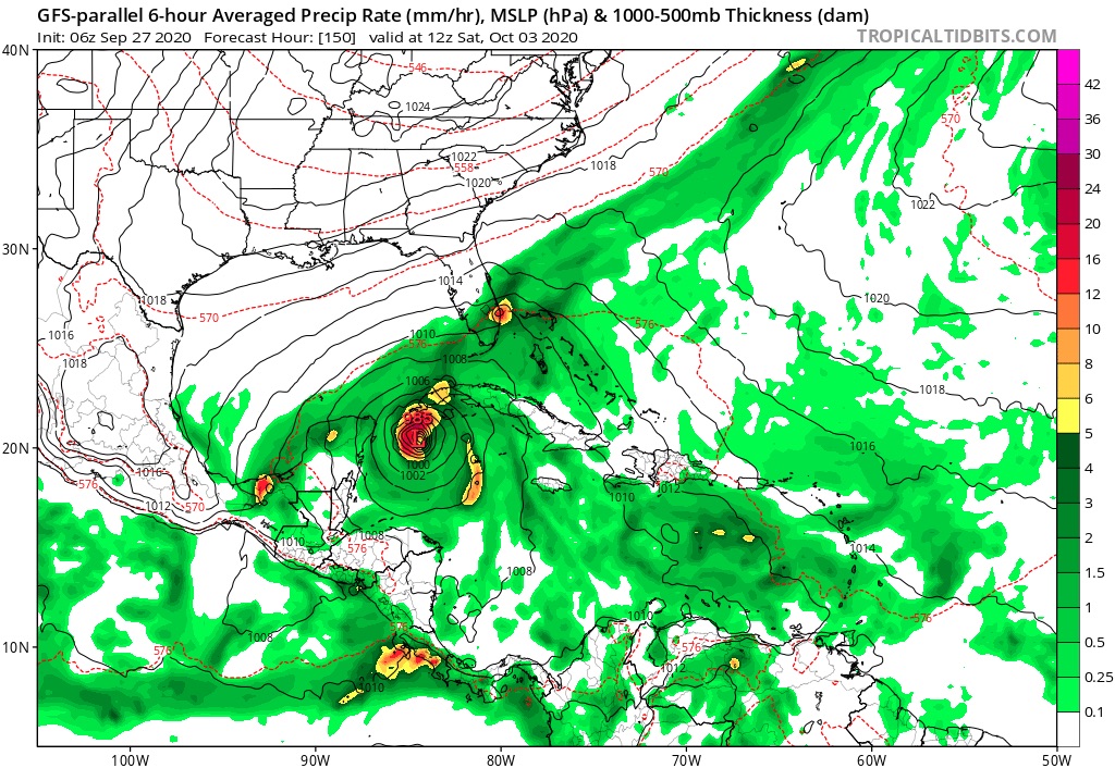
The precipitation field suggests a strongly sheared system, like Irene ‘99. The synoptic setup would suggest a strong TS or low-end Cat-1 hurricane.

otowntiger wrote:. Not only that but quite possibly one that could miss all of Florida to the south.Shell Mound wrote:SFLcane wrote:06z Para...
Potentially overdone but who knows You can tell it’s going to go NE look at that front.
https://i.postimg.cc/8CHghPp1/CD145-C3-E-89-DF-44-B2-8-B0-E-ED6-E28594-B4-F.jpg
The precipitation field suggests a strongly sheared system, like Irene ‘99. The synoptic setup would suggest a strong TS or low-end Cat-1 hurricane.
SFLcane wrote:06z Para...
Potentially overdone but who knows You can tell it’s going to go NE look at that front.
https://i.postimg.cc/8CHghPp1/CD145-C3-E-89-DF-44-B2-8-B0-E-ED6-E28594-B4-F.jpg
toad strangler wrote:SFLcane wrote:06z Para...
Potentially overdone but who knows You can tell it’s going to go NE look at that front.
https://i.postimg.cc/8CHghPp1/CD145-C3-E-89-DF-44-B2-8-B0-E-ED6-E28594-B4-F.jpg
LOLLOL at 200 hrs plus on that run
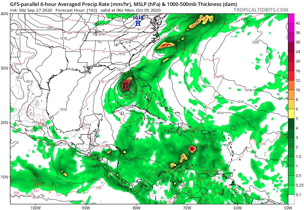
Steve wrote:That GFS Parallel run ends at 270 (11 1/4 days) with the first storm not crossing Florida but bouncing west and weakening under strong high pressure as a stronger system comes up from the Caribbean.
https://www.tropicaltidbits.com/analysi ... 706&fh=270
otowntiger wrote:. Not only that but quite possibly one that could miss all of Florida to the south.Shell Mound wrote:SFLcane wrote:06z Para...
Potentially overdone but who knows You can tell it’s going to go NE look at that front.
https://i.postimg.cc/8CHghPp1/CD145-C3-E-89-DF-44-B2-8-B0-E-ED6-E28594-B4-F.jpg
The precipitation field suggests a strongly sheared system, like Irene ‘99. The synoptic setup would suggest a strong TS or low-end Cat-1 hurricane.

Steve wrote:That GFS Parallel run ends at 270 (11 1/4 days) with the first storm not crossing Florida but bouncing west and weakening under strong high pressure as a stronger system comes up from the Caribbean.
https://www.tropicaltidbits.com/analysi ... 706&fh=270
Aric Dunn wrote:And right on queue the wave that may develop in a few days in the western carrib has begun increasing convection as it approaches the islands...
I suppose we can start a thread on it now that there is an actual feature..
https://i.ibb.co/pZyJWY8/LABELS-19700101-000000-23.gif
Steve wrote:That GFS Parallel run ends at 270 (11 1/4 days) with the first storm not crossing Florida but bouncing west and weakening under strong high pressure as a stronger system comes up from the Caribbean.
https://www.tropicaltidbits.com/analysi ... 706&fh=270


toad strangler wrote:otowntiger wrote:. Not only that but quite possibly one that could miss all of Florida to the south.Shell Mound wrote:The precipitation field suggests a strongly sheared system, like Irene ‘99. The synoptic setup would suggest a strong TS or low-end Cat-1 hurricane.
Sure, if you buy a front clearing the peninsula in October.
TheStormExpert wrote:blp wrote:GEFS P look like the old CMC wants to ramp things up too much in my opinion.
https://i.ibb.co/NKvXs0C/8e4bdb55-b6d0-460d-9a3b-4de993dabad0.gif
Didn’t we just get an upgrade to the GFS the other day? If so than what’s this?
MarioProtVI wrote:Shell Mound wrote:There’s been a wall of shear over the western Caribbean since at least 2011. Why should it let up just now? Furthermore, shear thus far has been consistently higher than in a typical Niña year, hence lower-than-expected ACE to date. At this point I think the western Caribbean will continue to be a “dead zone” as far as major hurricanes are concerned, owing to the influence of Niño-like TUTT and STJ activity. As someone previously mentioned, another Michael in the Gulf of Mexico would be exceptional.
We still have the entire month of October to get through, and also the models are probably not taking the La Niña into effect (particularly the GFS it seems). Don’t give up at all yet because 2020 is known for surprises, and the Western Caribbean has shown it is favourable this year more then other years with Marco and Nana (the former being a strong tropical storm before exiting and the latter becoming a brief C1).
SFLcane wrote:Steve wrote:That GFS Parallel run ends at 270 (11 1/4 days) with the first storm not crossing Florida but bouncing west and weakening under strong high pressure as a stronger system comes up from the Caribbean.
https://www.tropicaltidbits.com/analysi ... 706&fh=270
This run does not weaken it as much and brings it onshore SW Florida.
https://i.postimg.cc/xTSmTMjJ/DC8-AED99-077-D-46-B7-8717-F4001-C079-FC1.jpg
Users browsing this forum: No registered users and 147 guests


