2020 Global Model Runs Discussion (Out thru day 16)
Moderator: S2k Moderators
Forum rules
The posts in this forum are NOT official forecasts and should not be used as such. They are just the opinion of the poster and may or may not be backed by sound meteorological data. They are NOT endorsed by any professional institution or STORM2K. For official information, please refer to products from the National Hurricane Center and National Weather Service.
- SFLcane
- S2K Supporter

- Posts: 10281
- Age: 48
- Joined: Sat Jun 05, 2010 1:44 pm
- Location: Lake Worth Florida
Re: 2020 Global Model Runs Discussion (Out thru day 16)
Para says Florida your not getting away this year.
0 likes
- CyclonicFury
- Category 5

- Posts: 2033
- Age: 27
- Joined: Sun Jul 02, 2017 12:32 pm
- Location: NC
- Contact:
Re: 2020 Global Model Runs Discussion (Out thru day 16)
Shell Mound wrote:There’s been a wall of shear over the western Caribbean since at least 2011. Why should it let up just now? Furthermore, shear thus far has been consistently higher than in a typical Niña year, hence lower-than-expected ACE to date. At this point I think the western Caribbean will continue to be a “dead zone” as far as major hurricanes are concerned, owing to the influence of Niño-like TUTT and STJ activity. As someone previously mentioned, another Michael in the Gulf of Mexico would be exceptional.
Is this really true? Since the start of July, aside from a brief spike in mid-August during a suppressed CCKW, Caribbean shear has been consistently below normal thus far this season.

4 likes
NCSU B.S. in Meteorology Class of 2021. Tropical weather blogger at http://www.cyclonicfury.com. My forecasts and thoughts are NOT official, for official forecasts please consult the National Hurricane Center.
-
otowntiger
- Category 5

- Posts: 1932
- Joined: Tue Aug 31, 2004 7:06 pm
Re: 2020 Global Model Runs Discussion (Out thru day 16)
Shell Mound wrote:MarioProtVI wrote:Shell Mound wrote:There’s been a wall of shear over the western Caribbean since at least 2011. Why should it let up just now? Furthermore, shear thus far has been consistently higher than in a typical Niña year, hence lower-than-expected ACE to date. At this point I think the western Caribbean will continue to be a “dead zone” as far as major hurricanes are concerned, owing to the influence of Niño-like TUTT and STJ activity. As someone previously mentioned, another Michael in the Gulf of Mexico would be exceptional.
We still have the entire month of October to get through, and also the models are probably not taking the La Niña into effect (particularly the GFS it seems). Don’t give up at all yet because 2020 is known for surprises, and the Western Caribbean has shown it is favourable this year more then other years with Marco and Nana (the former being a strong tropical storm before exiting and the latter becoming a brief C1).
Well, so far 2020 has not behaved like a “typical” Niña year, given that ACE has been much lower than it should have been relative to NS. That’s certainly surprising, but it doesn’t garner the attention it merits, perhaps because people are more interested in bullish vs. bearish records, understandably so. Additionally, besides the GFS-P, most of the EPS members show broad, elongated MSLP fields, and only a handful show even a marginal hurricane, indicating that the EPS also shows strong westerly shear over the Gulf of Mexico, Yucatán Channel, and extreme northwestern Caribbean Sea. There hasn’t been a MH in the (north-)western Caribbean since Rina ‘11. As for Nana, it was questionably a hurricane at best. Currently models show Niño-like STJ activity near western Cuba as the potential system consolidates, so anything that forms would be highly sheared and weak at best, probably no more than a high-end TS or very marginal Cat-1, with strongest winds occurring spottily in squalls displaced well to the east of the centre.
Agreed- this scenario seems much more likely given what we’ve seen so far and what the models are actually showing, i.e. minimal effects from weak systems, at least for the next couple weeks. And beyond that , climo says to not expect much, but we’ll see.
0 likes
- toad strangler
- S2K Supporter

- Posts: 4546
- Joined: Sun Jul 28, 2013 3:09 pm
- Location: Earth
- Contact:
Re: 2020 Global Model Runs Discussion (Out thru day 16)
CyclonicFury wrote:Shell Mound wrote:There’s been a wall of shear over the western Caribbean since at least 2011. Why should it let up just now? Furthermore, shear thus far has been consistently higher than in a typical Niña year, hence lower-than-expected ACE to date. At this point I think the western Caribbean will continue to be a “dead zone” as far as major hurricanes are concerned, owing to the influence of Niño-like TUTT and STJ activity. As someone previously mentioned, another Michael in the Gulf of Mexico would be exceptional.
Is this really true? Since the start of July, aside from a brief spike in mid-August during a suppressed CCKW, Caribbean shear has been consistently below normal thus far this season.
https://i.imgur.com/Gs1sOg2_d.jpg?maxwidth=640&shape=thumb&fidelity=medium
The shellster is talking about modeled shear I do believe. Which, by the way, I don't believe.
3 likes
My Weather Station
https://www.wunderground.com/dashboard/pws/KFLPORTS603
https://www.wunderground.com/dashboard/pws/KFLPORTS603
-
Shell Mound
- Category 5

- Posts: 2432
- Age: 33
- Joined: Thu Sep 07, 2017 3:39 pm
- Location: St. Petersburg, FL → Scandinavia
Re: 2020 Global Model Runs Discussion (Out thru day 16)
CyclonicFury wrote:Shell Mound wrote:There’s been a wall of shear over the western Caribbean since at least 2011. Why should it let up just now? Furthermore, shear thus far has been consistently higher than in a typical Niña year, hence lower-than-expected ACE to date. At this point I think the western Caribbean will continue to be a “dead zone” as far as major hurricanes are concerned, owing to the influence of Niño-like TUTT and STJ activity. As someone previously mentioned, another Michael in the Gulf of Mexico would be exceptional.
Is this really true? Since the start of July, aside from a brief spike in mid-August during a suppressed CCKW, Caribbean shear has been consistently below normal thus far this season.
https://i.imgur.com/Gs1sOg2_d.jpg?maxwidth=640&shape=thumb&fidelity=medium
I’m not so sure that these charts have been accurate. During the same timeframe satellite imagery has shown stronger TUTTs than VSHD data indicated over the Caribbean and the MDR. Additionally, the VSHD chart for the MDR shows a period of enhanced VWS from mid-August through mid-September, though this was likely attributable to the passage of Typhoon Maysak, which induced AWB and TUTT formation over the North Atlantic during the said timeframe. Had VWS truly been as low as these charts indicate, however, I would have expected much greater ACE by now, even with the passage of the TUTT during peak season. Anyway, my point about the western Caribbean still stands. We’ll see whether the models start to show a much more conducive environment for a strong system.
0 likes
CVW / MiamiensisWx / Shell Mound
The posts in this forum are NOT official forecasts and should not be used as such. They are just the opinion of the poster and may or may not be backed by sound meteorological data. They are NOT endorsed by any professional institution or STORM2K. For official information, please refer to products from the NHC and NWS.
Re: 2020 Global Model Runs Discussion (Out thru day 16)
otowntiger wrote:Shell Mound wrote:MarioProtVI wrote:We still have the entire month of October to get through, and also the models are probably not taking the La Niña into effect (particularly the GFS it seems). Don’t give up at all yet because 2020 is known for surprises, and the Western Caribbean has shown it is favourable this year more then other years with Marco and Nana (the former being a strong tropical storm before exiting and the latter becoming a brief C1).
Well, so far 2020 has not behaved like a “typical” Niña year, given that ACE has been much lower than it should have been relative to NS. That’s certainly surprising, but it doesn’t garner the attention it merits, perhaps because people are more interested in bullish vs. bearish records, understandably so. Additionally, besides the GFS-P, most of the EPS members show broad, elongated MSLP fields, and only a handful show even a marginal hurricane, indicating that the EPS also shows strong westerly shear over the Gulf of Mexico, Yucatán Channel, and extreme northwestern Caribbean Sea. There hasn’t been a MH in the (north-)western Caribbean since Rina ‘11. As for Nana, it was questionably a hurricane at best. Currently models show Niño-like STJ activity near western Cuba as the potential system consolidates, so anything that forms would be highly sheared and weak at best, probably no more than a high-end TS or very marginal Cat-1, with strongest winds occurring spottily in squalls displaced well to the east of the centre.
Agreed- this scenario seems much more likely given what we’ve seen so far and what the models are actually showing, i.e. minimal effects from weak systems, at least for the next couple weeks. And beyond that , climo says to not expect much, but we’ll see.
The climo of ENSO based analogs tells me that the W Caribbean needs to be watched closely for potential geneses all the way through about 10/20. It is liable to feel like an eternity getting through this upcoming 3 week period whether or not anything actually threatens. This board will continue to be very busy. I’ll be surprised if there isn’t at least one H threat to some part of the CONUS, most likely FL of any one state. Two TS+ threats to the CONUS, like what happened in 1964, wouldn’t at all surprise me. But nothing is set in stone as who’s to say that this won’t be another benign end of season like 1942 or 2007.
3 likes
Personal Forecast Disclaimer:
The posts in this forum are NOT official forecasts and should not be used as such. They are just the opinion of the poster and may or may not be backed by sound meteorological data. They are NOT endorsed by any professional institution or storm2k.org. For official information, please refer to the NHC and NWS products.
The posts in this forum are NOT official forecasts and should not be used as such. They are just the opinion of the poster and may or may not be backed by sound meteorological data. They are NOT endorsed by any professional institution or storm2k.org. For official information, please refer to the NHC and NWS products.
- Spacecoast
- Category 2

- Posts: 773
- Joined: Thu Aug 31, 2017 2:03 pm
Re: 2020 Global Model Runs Discussion (Out thru day 16)
otowntiger wrote:Shell Mound wrote:MarioProtVI wrote:We still have the entire month of October to get through, and also the models are probably not taking the La Niña into effect (particularly the GFS it seems). Don’t give up at all yet because 2020 is known for surprises, and the Western Caribbean has shown it is favourable this year more then other years with Marco and Nana (the former being a strong tropical storm before exiting and the latter becoming a brief C1).
Well, so far 2020 has not behaved like a “typical” Niña year, given that ACE has been much lower than it should have been relative to NS. That’s certainly surprising, but it doesn’t garner the attention it merits, perhaps because people are more interested in bullish vs. bearish records, understandably so. Additionally, besides the GFS-P, most of the EPS members show broad, elongated MSLP fields, and only a handful show even a marginal hurricane, indicating that the EPS also shows strong westerly shear over the Gulf of Mexico, Yucatán Channel, and extreme northwestern Caribbean Sea. There hasn’t been a MH in the (north-)western Caribbean since Rina ‘11. As for Nana, it was questionably a hurricane at best. Currently models show Niño-like STJ activity near western Cuba as the potential system consolidates, so anything that forms would be highly sheared and weak at best, probably no more than a high-end TS or very marginal Cat-1, with strongest winds occurring spottily in squalls displaced well to the east of the centre.
Agreed- this scenario seems much more likely given what we’ve seen so far and what the models are actually showing, i.e. minimal effects from weak systems, at least for the next couple weeks. And beyond that , climo says to not expect much, but we’ll see.
Aren't some models are showing more than minimal,weak systems?
One of the GEFS members is showing a CAT4 into S FL @180 hr, weakening to CAT3 as it goes through Central FL., followed by another Cat4 later
I know it's only one member, but still.
And the GFS-Para also showing a CAT4 development.
I realize these models do poorly with intensity, but can we really discount them that much?
0 likes
Re: 2020 Global Model Runs Discussion (Out thru day 16)
Aric Dunn wrote:And right on queue the wave that may develop in a few days in the western carrib has begun increasing convection as it approaches the islands...
I suppose we can start a thread on it now that there is an actual feature..
https://i.ibb.co/pZyJWY8/LABELS-19700101-000000-23.gif
I had started a thread about the convective blow up along the northern end of this wave yesterday. That all dissipated but it looked like there had been some sort of weak mid/upper level spin present. That area appears to still be moving sw so if I were to bet I’d think the energy from the northern end of the wave will be the potential catalyst for development once it continues further sw into the central Caribbean
0 likes
Re: 2020 Global Model Runs Discussion (Out thru day 16)
otowntiger wrote:Shell Mound wrote:MarioProtVI wrote:We still have the entire month of October to get through, and also the models are probably not taking the La Niña into effect (particularly the GFS it seems). Don’t give up at all yet because 2020 is known for surprises, and the Western Caribbean has shown it is favourable this year more then other years with Marco and Nana (the former being a strong tropical storm before exiting and the latter becoming a brief C1).
Well, so far 2020 has not behaved like a “typical” Niña year, given that ACE has been much lower than it should have been relative to NS. That’s certainly surprising, but it doesn’t garner the attention it merits, perhaps because people are more interested in bullish vs. bearish records, understandably so. Additionally, besides the GFS-P, most of the EPS members show broad, elongated MSLP fields, and only a handful show even a marginal hurricane, indicating that the EPS also shows strong westerly shear over the Gulf of Mexico, Yucatán Channel, and extreme northwestern Caribbean Sea. There hasn’t been a MH in the (north-)western Caribbean since Rina ‘11. As for Nana, it was questionably a hurricane at best. Currently models show Niño-like STJ activity near western Cuba as the potential system consolidates, so anything that forms would be highly sheared and weak at best, probably no more than a high-end TS or very marginal Cat-1, with strongest winds occurring spottily in squalls displaced well to the east of the centre.
Agreed- this scenario seems much more likely given what we’ve seen so far and what the models are actually showing, i.e. minimal effects from weak systems, at least for the next couple weeks. And beyond that , climo says to not expect much, but we’ll see.
For those interested, i'd suggest taking a look at the Continental US upper 200mb forecast regarding hints toward more LaNina-like split flow developing along with a switch toward deep troughing in the west. Around 324 hr's there appears to be a developing shift to the upper air flow. This looks to evolve into big time upper level ridging over the Great Lakes and anticyclonic conditions setting up over the W. Caribbean and GOM toward the end of the forecast cycle. Folks, that's around Oct. 12 time frame and potentially at a point where one of three tropical waves might moving west of 75W. My only point is that I wouldn't be so quick to assume that any developing storm in the W. Caribbean will be a weak and sloppy "frontal hugger". If you start looking to closely at model run to run output, it's easy to get caught up in that thinking. What if timing of genesis is delayed by 48-72 hours? Do you not think this will potentially impact both intensity and track? We may well see one sloppy weak system evolve initially in the nearer term but I'm not so sure that will be indicative of development for any second system 5-8 days later. I think the first two weeks of October will be interesting but also show some evolving upper air changes (especially toward the 2nd week going forward)
6 likes
Andy D
(For official information, please refer to the NHC and NWS products.)
(For official information, please refer to the NHC and NWS products.)
Re: 2020 Global Model Runs Discussion (Out thru day 16)
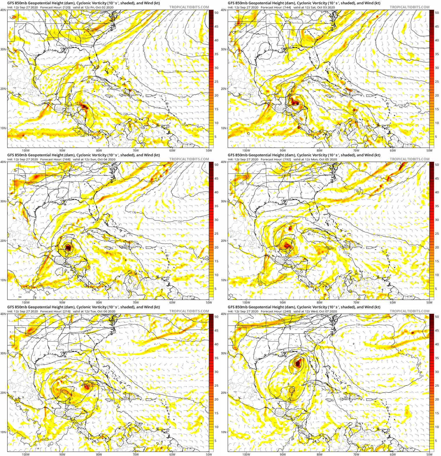
The 12Z GFS is notable in that it is back to an early (October 3rd) genesis. This is the first GFS run in a number of days with an actual TC that early. Many runs were like that early last week, but then they stopped and instead delayed any genesis a couple of days.
Last edited by LarryWx on Sun Sep 27, 2020 11:49 am, edited 2 times in total.
4 likes
Personal Forecast Disclaimer:
The posts in this forum are NOT official forecasts and should not be used as such. They are just the opinion of the poster and may or may not be backed by sound meteorological data. They are NOT endorsed by any professional institution or storm2k.org. For official information, please refer to the NHC and NWS products.
The posts in this forum are NOT official forecasts and should not be used as such. They are just the opinion of the poster and may or may not be backed by sound meteorological data. They are NOT endorsed by any professional institution or storm2k.org. For official information, please refer to the NHC and NWS products.
-
Aric Dunn
- Category 5

- Posts: 21238
- Age: 43
- Joined: Sun Sep 19, 2004 9:58 pm
- Location: Ready for the Chase.
- Contact:
Re: 2020 Global Model Runs Discussion (Out thru day 16)
LarryWx wrote:The 12Z GFS is notable in that it is back to an early (October 3rd) genesis.
yeah, that is what I was waiting for.
GFS was showing Oct 1-3rd two weeks ago. now it isback to that.
5 likes
Note: If I make a post that is brief. Please refer back to previous posts for the analysis or reasoning. I do not re-write/qoute what my initial post said each time.
If there is nothing before... then just ask
Space & Atmospheric Physicist, Embry-Riddle Aeronautical University,
I believe the sky is falling...
If there is nothing before... then just ask
Space & Atmospheric Physicist, Embry-Riddle Aeronautical University,
I believe the sky is falling...
- Spacecoast
- Category 2

- Posts: 773
- Joined: Thu Aug 31, 2017 2:03 pm
Re: 2020 Global Model Runs Discussion (Out thru day 16)
Aric Dunn wrote:LarryWx wrote:The 12Z GFS is notable in that it is back to an early (October 3rd) genesis.
yeah, that is what I was waiting for.
GFS was showing Oct 1-3rd two weeks ago. now it isback to that.
GFS looks to send it into Yucatan.
Is that related to the convection E of Antilles you posted earlier?
And isn't it the same system that GFS-P shows on the West tip of Cuba on Oct 3?
And the same system NAVGEM shows east of Havana?
0 likes
- gatorcane
- S2K Supporter

- Posts: 23708
- Age: 48
- Joined: Sun Mar 13, 2005 3:54 pm
- Location: Boca Raton, FL
Re: 2020 Global Model Runs Discussion (Out thru day 16)
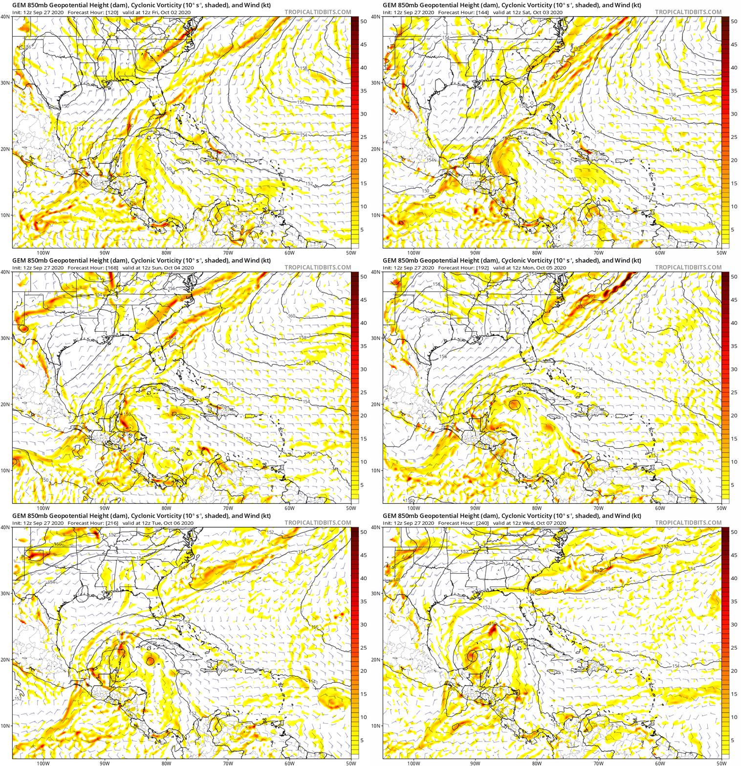
12C CMC 120 to 240 hour animation. Not far off the GFS really with the idea of two distinct areas of vorticity just weaker:

2 likes
- Spacecoast
- Category 2

- Posts: 773
- Joined: Thu Aug 31, 2017 2:03 pm
Re: 2020 Global Model Runs Discussion (Out thru day 16)
FSU Genesis Prob now has GFS (12z) joinIng the 6z NAVGEM....
0-48hr = 8% prob
0-120hr = 48% prob
0-168hrr = 64% prob (shown below)

0-48hr = 8% prob
0-120hr = 48% prob
0-168hrr = 64% prob (shown below)

0 likes
- toad strangler
- S2K Supporter

- Posts: 4546
- Joined: Sun Jul 28, 2013 3:09 pm
- Location: Earth
- Contact:
Re: 2020 Global Model Runs Discussion (Out thru day 16)
SFLcane wrote:Para says Florida your not getting away this year.
Para is all alone so far no?
0 likes
My Weather Station
https://www.wunderground.com/dashboard/pws/KFLPORTS603
https://www.wunderground.com/dashboard/pws/KFLPORTS603
- gatorcane
- S2K Supporter

- Posts: 23708
- Age: 48
- Joined: Sun Mar 13, 2005 3:54 pm
- Location: Boca Raton, FL
Re: 2020 Global Model Runs Discussion (Out thru day 16)
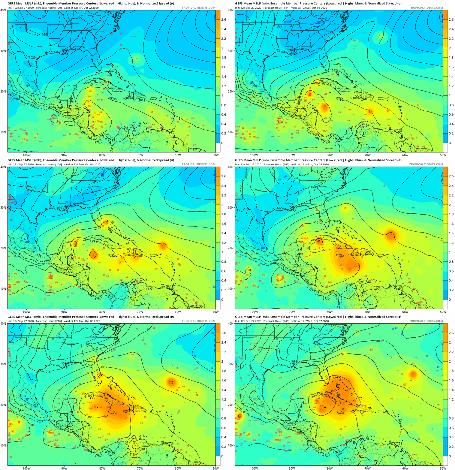
MUCH stronger signal from the GEFS 
Also seems to be leaning more toward the eastern area for development.
120 to 240 hour animation below
Also seems to be leaning more toward the eastern area for development.
120 to 240 hour animation below

0 likes
Re: 2020 Global Model Runs Discussion (Out thru day 16)
GFS para is the new crazy Canadian (which now seems somewhat sane). This thread the past week certainly validates the prohibition against model storm threads. Time is ticking on cane season 2020 and i'm starting to feel good although i've been known to jump the gun...
0 likes
- Spacecoast
- Category 2

- Posts: 773
- Joined: Thu Aug 31, 2017 2:03 pm
Re: 2020 Global Model Runs Discussion (Out thru day 16)
gatorcane wrote:MUCH stronger signal from the GEFS
Also seems to be leaning more toward the eastern area for development.
120 to 240 hour animation below
https://i.postimg.cc/xdGY97t5/gfs-ememb-lowlocs-watl-fh120-240.gif
A lot of 2.6 spread...higher spreads then usual, indicating either low confidence in the position of a low/high, or low confidence in its pressure (or both).
0 likes
Who is online
Users browsing this forum: Ulf and 147 guests


