

2022 Indicators (SSTs/SAL/MSLP/Shear/Steering/Instability) and >Day 16 Models
Moderator: S2k Moderators
Forum rules

The posts in this forum are NOT official forecasts and should not be used as such. They are just the opinion of the poster and may or may not be backed by sound meteorological data. They are NOT endorsed by any professional institution or STORM2K. For official information, please refer to products from the National Hurricane Center and National Weather Service.
Re: 2022 Indicators (SSTs/SAL/MSLP/Shear/Steering/Instability) and >Day 16 Models
Dangerous synoptic set up over the next 2 weeks for the US. Lets hope for the dry air to keep the TWs at bay over the next few days.
0 likes
Re: 2022 Indicators (SSTs/SAL/MSLP/Shear/Steering/Instability) and >Day 16 Models
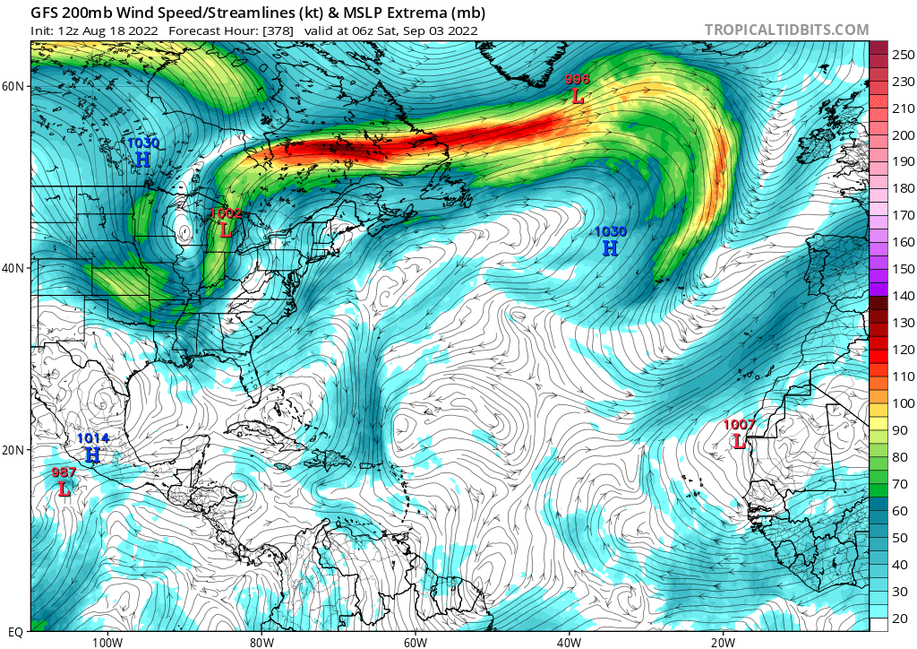
SFLcane wrote:This GFS run is something!
Upper level low all the way to the equator
https://i.postimg.cc/50B9n9jG/gfs.png
Do you believe a model's 376 hr UL forecast?
4 likes

Re: 2022 Indicators (SSTs/SAL/MSLP/Shear/Steering/Instability) and >Day 16 Models
Category5Kaiju wrote:Hammy wrote:WiscoWx02 wrote:
That too…or November cough Eta/Iota cough. Maybe 2002 is what this season ends up being like. Yeah I know it isn’t El Nino but still…there are obviously other factors to consider other than ENSO now days.
I'm still sticking to 1988 analog but this isn't entirely out of the question either--I don't recall who but somebody pointed out that the equatorial E Pacific is functionally in a Nino even if the rest of it isn't.
1988 would have had a very wild and active September and October had it been in a +AMO imho; I agree, I do think that that is a decent analog, especially when considering how we *could* potentially see the big gun hurricanes after August it seems like (from what I can theorize, it makes sense if this season is a backloaded one; iirc, there was some talk last year about how active Augusts actually may not be conducive for above average seasons, and while 2021 did end up above average, considering its relatively active August, I think that it may have had the opportunity to be more active if its MJO/CCKW timing was a bit different, as aside from Larry and Sam, September and October were not all that crazy busy).
Also, I personally disagree that we are "functionally" in a Nino; that does not explain why the EPAC, while active, still failed to produce a swarm of major hurricanes (like what we saw in 2014 or 2018), and why the WPAC has been phenomenally silent. The behaviors of both basins are very much Nina-like.
Found the source, essentially isolated the equatorial E Pacific. Not saying this will necessarily put a damper on the season, but should be looked at as a possible reason after the season if we do in fact have reduced activity.
https://twitter.com/DerekOrtt/status/1557778760753086471
0 likes
The above post is not official and should not be used as such. It is the opinion of the poster and may or may not be backed by sound meteorological data. It is not endorsed by any professional institution or storm2k.org. For official information, please refer to the NHC and NWS products.
-
Monsoonjr99
- Tropical Storm

- Posts: 210
- Age: 26
- Joined: Fri Sep 21, 2018 11:22 pm
- Location: Inland Empire, SoCal
Re: 2022 Indicators (SSTs/SAL/MSLP/Shear/Steering/Instability) and >Day 16 Models
NDG wrote:Dangerous synoptic set up over the next 2 weeks for the US. Lets hope for the dry air to keep the TWs at bay over the next few days.
Though dry air in the MDR might mean waves developing further west, which might only increase threat to land.
2 likes
The posts in this forum are NOT official forecasts and should not be used as such. They are just the opinion of the poster and may or may not be backed by sound meteorological data. They are NOT endorsed by any professional institution or STORM2K. For official information, please refer to products from the NHC and NWS.
Some Californian who codes things and tracks weather.
Kay '22, Hilary '23
Re: 2022 Indicators (SSTs/SAL/MSLP/Shear/Steering/Instability) and >Day 16 Models
SFLcane wrote:Similar issues to 2013 surely but Not exactly the same. Shear isn't as bad but dry air is worse. Hate to say it but september could face similar issues. Potentially we get some recurvers that develop in the subtropics.
I think a ridiculously quiet year is definitely on the table now.
Something to keep in mind that in 2013 the MDR didn't turn bone dry until late in August into September and October.
3 likes
-
cycloneye

- Admin

- Posts: 149275
- Age: 69
- Joined: Thu Oct 10, 2002 10:54 am
- Location: San Juan, Puerto Rico
Re: 2022 Indicators (SSTs/SAL/MSLP/Shear/Steering/Instability) and >Day 16 Models
0 likes
Visit the Caribbean-Central America Weather Thread where you can find at first post web cams,radars
and observations from Caribbean basin members Click Here
and observations from Caribbean basin members Click Here
-
Yellow Evan

- Professional-Met

- Posts: 16231
- Age: 27
- Joined: Fri Jul 15, 2011 12:48 pm
- Location: Henderson, Nevada/Honolulu, HI
- Contact:
Re: 2022 Indicators (SSTs/SAL/MSLP/Shear/Steering/Instability) and >Day 16 Models
Hammy wrote:Category5Kaiju wrote:Hammy wrote:
I'm still sticking to 1988 analog but this isn't entirely out of the question either--I don't recall who but somebody pointed out that the equatorial E Pacific is functionally in a Nino even if the rest of it isn't.
1988 would have had a very wild and active September and October had it been in a +AMO imho; I agree, I do think that that is a decent analog, especially when considering how we *could* potentially see the big gun hurricanes after August it seems like (from what I can theorize, it makes sense if this season is a backloaded one; iirc, there was some talk last year about how active Augusts actually may not be conducive for above average seasons, and while 2021 did end up above average, considering its relatively active August, I think that it may have had the opportunity to be more active if its MJO/CCKW timing was a bit different, as aside from Larry and Sam, September and October were not all that crazy busy).
Also, I personally disagree that we are "functionally" in a Nino; that does not explain why the EPAC, while active, still failed to produce a swarm of major hurricanes (like what we saw in 2014 or 2018), and why the WPAC has been phenomenally silent. The behaviors of both basins are very much Nina-like.
Found the source, essentially isolated the equatorial E Pacific. Not saying this will necessarily put a damper on the season, but should be looked at as a possible reason after the season if we do in fact have reduced activity.
https://twitter.com/DerekOrtt/status/1557778760753086471/photo/1
https://twitter.com/wxtca/status/1560374192083636224
3 likes
Re: 2022 Indicators (SSTs/SAL/MSLP/Shear/Steering/Instability) and >Day 16 Models
Last few CFS runs show at least 5-6 MDR storms during September (in addition to three at the end of this month) in addition to what seem to be three decent-strength systems for the Gulf so consistent that July/August are not an indicator of September. In fact, the model shows basin-wide activity lasting well into October.
0 likes
The above post is not official and should not be used as such. It is the opinion of the poster and may or may not be backed by sound meteorological data. It is not endorsed by any professional institution or storm2k.org. For official information, please refer to the NHC and NWS products.
-
cycloneye
- Admin
- Posts: 149275
- Age: 69
- Joined: Thu Oct 10, 2002 10:54 am
- Location: San Juan, Puerto Rico
Re: 2022 Indicators (SSTs/SAL/MSLP/Shear/Steering/Instability) and >Day 16 Models
Who has the CFS that has plenty of activity?
0 likes
Visit the Caribbean-Central America Weather Thread where you can find at first post web cams,radars
and observations from Caribbean basin members Click Here
and observations from Caribbean basin members Click Here
-
skyline385

- Category 5

- Posts: 2728
- Age: 35
- Joined: Wed Aug 26, 2020 11:15 pm
- Location: Houston TX
Re: 2022 Indicators (SSTs/SAL/MSLP/Shear/Steering/Instability) and >Day 16 Models
Hammy wrote:Last few CFS runs show at least 5-6 MDR storms during September (in addition to three at the end of this month) in addition to what seem to be three decent-strength systems for the Gulf so consistent that July/August are not an indicator of September. In fact, the model shows basin-wide activity lasting well into October.
I am not the biggest fan of CFS but that would be in line with today's weekly forecast. We might possibly get a very busy later half of September. Also, all the indicators are getting bullish as well. SST anomalies are rising, shear is gradually decreasing, SAL will eventually end as well.
1 likes
Re: 2022 Indicators (SSTs/SAL/MSLP/Shear/Steering/Instability) and >Day 16 Models
cycloneye wrote:Who has the CFS that has plenty of activity?
https://www.weatheronline.co.uk/cgi-bin/expertcharts?LANG=en&MENU=0000000000&CONT=noat&MODELL=cfs&MODELLTYP=1&BASE=-&VAR=pslv&HH=12&ZOOM=0&WMO=&ARCHIV=0&LOOP=1&RES=0
Looks like somewhat steady activity for about 6-8 weeks starting at the end of August. Gulf and Caribbean views have some decent strength storms for the model resolution (only once have I seen sub-990mb pressure on this model, and that was Michael)
Obviously individual storm tracks can likely dismissed but it's a good indicator of things--the model's been pretty quiet when it was showing July/most of August that far out.
skyline385 wrote:I am not the biggest fan of CFS but that would be in line with today's weekly forecast. We might possibly get a very busy later half of September. Also, all the indicators are getting bullish as well. SST anomalies are rising, shear is gradually decreasing, SAL will eventually end as well.
It's actually a good indicator when looked at over a length of time and I feel is better than the monthly departures when it comes to activity. The problem arises when people try using it as a direct forecasting tool during a block of time (though it did accurately show Michael a full month out along with October 2020's activity)
4 likes
The above post is not official and should not be used as such. It is the opinion of the poster and may or may not be backed by sound meteorological data. It is not endorsed by any professional institution or storm2k.org. For official information, please refer to the NHC and NWS products.
Re: 2022 Indicators (SSTs/SAL/MSLP/Shear/Steering/Instability) and >Day 16 Models
Hammy wrote:Last few CFS runs show at least 5-6 MDR storms during September (in addition to three at the end of this month) in addition to what seem to be three decent-strength systems for the Gulf so consistent that July/August are not an indicator of September. In fact, the model shows basin-wide activity lasting well into October.
I thought the CFS just last week was showing just a couple of storms through September? It changed its mind fast.
0 likes
Re: 2022 Indicators (SSTs/SAL/MSLP/Shear/Steering/Instability) and >Day 16 Models
NDG wrote:Hammy wrote:Last few CFS runs show at least 5-6 MDR storms during September (in addition to three at the end of this month) in addition to what seem to be three decent-strength systems for the Gulf so consistent that July/August are not an indicator of September. In fact, the model shows basin-wide activity lasting well into October.
I thought the CFS just last week was showing just a couple of storms through September? It changed its mind fast.
It had a couple of sporadic bad runs, notably the isolated one storm in September run (which I mentioned mostly as ironic as the sole storm it showed took an Andrew-type track)
Similarly 2014 (when I first started watching the model) had mostly a quiet season, but a few had more activity (hence why it's best to watch over several runs before getting an idea the trend)
2 likes
The above post is not official and should not be used as such. It is the opinion of the poster and may or may not be backed by sound meteorological data. It is not endorsed by any professional institution or storm2k.org. For official information, please refer to the NHC and NWS products.
-
Hurricaneman

- Category 5
- Posts: 7404
- Age: 45
- Joined: Tue Aug 31, 2004 3:24 pm
- Location: central florida
Re: 2022 Indicators (SSTs/SAL/MSLP/Shear/Steering/Instability) and >Day 16 Models
Could be quite the backloaded season if models are correct and the CFS shows a possible hyperactive September and October so we’ll see how this season goes
4 likes

Re: 2022 Indicators (SSTs/SAL/MSLP/Shear/Steering/Instability) and >Day 16 Models
I predicted 11 storms in September and still feeling confident about that. going to be a September to Remember
0 likes
-
Deshaunrob17
- Tropical Storm
- Posts: 211
- Joined: Tue Aug 18, 2020 7:49 am
Re: 2022 Indicators (SSTs/SAL/MSLP/Shear/Steering/Instability) and >Day 16 Models
Hammy wrote:Category5Kaiju wrote:Hammy wrote:
I'm still sticking to 1988 analog but this isn't entirely out of the question either--I don't recall who but somebody pointed out that the equatorial E Pacific is functionally in a Nino even if the rest of it isn't.
1988 would have had a very wild and active September and October had it been in a +AMO imho; I agree, I do think that that is a decent analog, especially when considering how we *could* potentially see the big gun hurricanes after August it seems like (from what I can theorize, it makes sense if this season is a backloaded one; iirc, there was some talk last year about how active Augusts actually may not be conducive for above average seasons, and while 2021 did end up above average, considering its relatively active August, I think that it may have had the opportunity to be more active if its MJO/CCKW timing was a bit different, as aside from Larry and Sam, September and October were not all that crazy busy).
Also, I personally disagree that we are "functionally" in a Nino; that does not explain why the EPAC, while active, still failed to produce a swarm of major hurricanes (like what we saw in 2014 or 2018), and why the WPAC has been phenomenally silent. The behaviors of both basins are very much Nina-like.
Found the source, essentially isolated the equatorial E Pacific. Not saying this will necessarily put a damper on the season, but should be looked at as a possible reason after the season if we do in fact have reduced activity.
https://twitter.com/DerekOrtt/status/1557778760753086471/photo/1
Didn’t 2008 have that same setup?
0 likes
-
Category5Kaiju

- Category 5
- Posts: 4330
- Joined: Thu Dec 24, 2020 12:45 pm
- Location: Seattle and Phoenix
Re: 2022 Indicators (SSTs/SAL/MSLP/Shear/Steering/Instability) and >Day 16 Models
Any thoughts and opinions regarding this? Figured this may allow for some interesting discussions going forward
https://twitter.com/dmorris9661/status/1560590710214053889
https://twitter.com/dmorris9661/status/1560590710214053889
0 likes
Unless explicitly stated, all info in my posts is based on my own opinions and observations. Tropical storms and hurricanes can be extremely dangerous. Refer to an accredited weather research agency or meteorologist if you need to make serious decisions regarding an approaching storm.
-
SFLcane

- S2K Supporter

- Posts: 10281
- Age: 48
- Joined: Sat Jun 05, 2010 1:44 pm
- Location: Lake Worth Florida
Re: 2022 Indicators (SSTs/SAL/MSLP/Shear/Steering/Instability) and >Day 16 Models
Category5Kaiju wrote:Any thoughts and opinions regarding this? Figured this may allow for some interesting discussions going forward
https://twitter.com/dmorris9661/status/1560590710214053889
I can try my best..

0 likes
-
toad strangler

- S2K Supporter
- Posts: 4546
- Joined: Sun Jul 28, 2013 3:09 pm
- Location: Earth
- Contact:
Re: 2022 Indicators (SSTs/SAL/MSLP/Shear/Steering/Instability) and >Day 16 Models
Category5Kaiju wrote:Any thoughts and opinions regarding this? Figured this may allow for some interesting discussions going forward
https://twitter.com/dmorris9661/status/1560590710214053889
Danny Morris is a CPA. Not a met, nor on my goto list. But GBA

I feel that with all the indicators that we have talked about for months still showing enhanced cyclone potential there will be a champagne cork like pop off to the season.
5 likes
My Weather Station
https://www.wunderground.com/dashboard/pws/KFLPORTS603
https://www.wunderground.com/dashboard/pws/KFLPORTS603
-
Category5Kaiju
- Category 5
- Posts: 4330
- Joined: Thu Dec 24, 2020 12:45 pm
- Location: Seattle and Phoenix
Re: 2022 Indicators (SSTs/SAL/MSLP/Shear/Steering/Instability) and >Day 16 Models
toad strangler wrote:Category5Kaiju wrote:Any thoughts and opinions regarding this? Figured this may allow for some interesting discussions going forward
https://twitter.com/dmorris9661/status/1560590710214053889
Danny Morris is a CPA. Not a met, nor on my goto list. But GBA
I feel that with all the indicators that we have talked about for months still showing enhanced cyclone potential there will be a champagne cork like pop off to the season.
Yeah, I agree; tbh, there's all this screaming about 2013 going on now it seems, but at the same time I have yet to hear about anything regarding a thermohaline circulation collapse, which I believe is the scientifically-established consensus behind why 2013 did so poorly. And as another poster here mentioned, the MDR turned bone dry late August that year, while this year (at least so far) there's not really any evidence of that kind of pattern...idk, guessing it's just peak cancel-yelling time of the year...
6 likes
Unless explicitly stated, all info in my posts is based on my own opinions and observations. Tropical storms and hurricanes can be extremely dangerous. Refer to an accredited weather research agency or meteorologist if you need to make serious decisions regarding an approaching storm.
Who is online
Users browsing this forum: Google Adsense [Bot] and 332 guests