SFLcane wrote:Gfs will nail just about every community in the gulf coast during the next 10 days. Maybe the next run cuts through Cuba and out to sea.
Still waiting for the NOLA run
Sent from my iPhone using Tapatalk
Moderator: S2k Moderators


SFLcane wrote:Gfs will nail just about every community in the gulf coast during the next 10 days. Maybe the next run cuts through Cuba and out to sea.
skyline385 wrote:SFLcane wrote:Gfs will nail just about every community in the gulf coast during the next 10 days. Maybe the next run cuts through Cuba and out to sea.
Still waiting for the NOLA run
Sent from my iPhone using Tapatalk


IcyTundra wrote:skyline385 wrote:SFLcane wrote:Gfs will nail just about every community in the gulf coast during the next 10 days. Maybe the next run cuts through Cuba and out to sea.
Still waiting for the NOLA run
Sent from my iPhone using Tapatalk
We already had the Houston run and FL panhandle run. Next will be the NOLA run followed by the Lake Charles run.


pgoss11 wrote:At what point will this be tagged as an Invest?
PTrackerLA wrote:18z GFS vs 12z EURO at 240hrs, this is about the strongest model agreement I've seen between the GFS and Euro at this range...
https://i.imgur.com/xhGo21Z.jpg


pgoss11 wrote:At what point will this be tagged as an Invest?
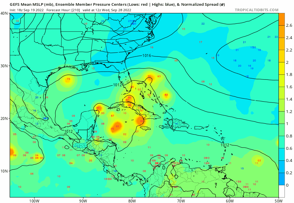


SFLcane wrote:Once again a good chunk of long range GEFS ensembles head north towards Cuba and Florida.
https://i.postimg.cc/8zQVxcsj/08455-C9-F-1-F60-4664-8-E24-36074832-B7-BF.gif

SFLcane wrote:Once again a good chunk of long range GEFS ensembles head north towards Cuba and Florida.
https://i.postimg.cc/8zQVxcsj/08455-C9-F-1-F60-4664-8-E24-36074832-B7-BF.gif

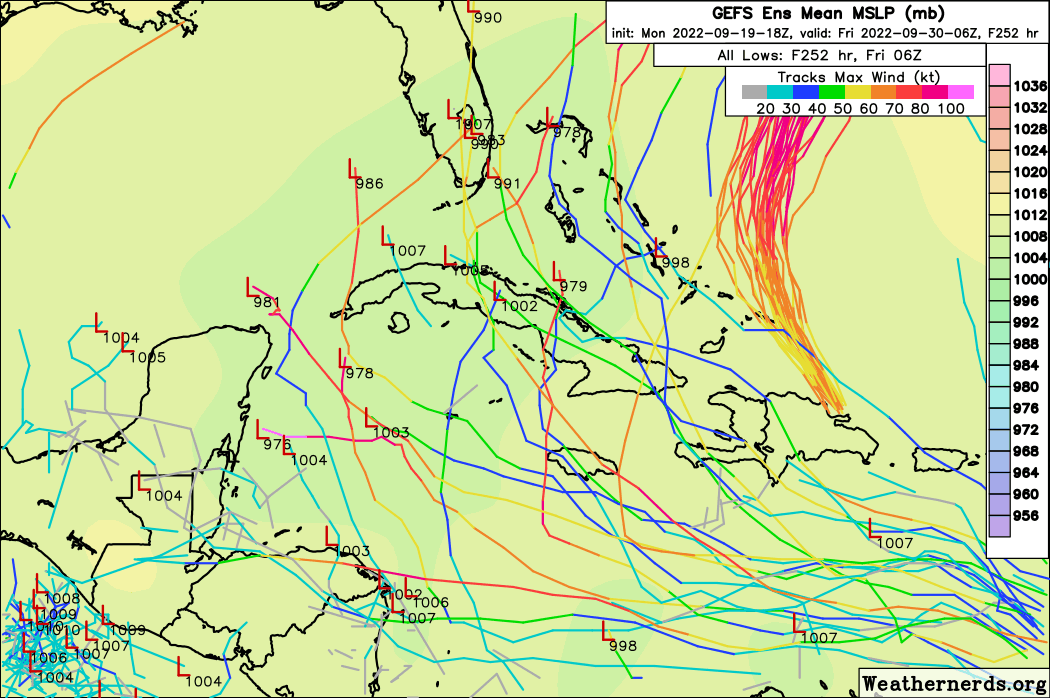


SFLcane wrote:Now some GEFS ensembles hooking before Florida into the Bahamas. I’d certainly watch ensembles other then focusing on 5+ day op models. My opinion atleast.
Climo certainly favors something yanked north and northeast in time.
https://i.postimg.cc/tRzz6MGJ/FB4-F38-B1-1440-4-BEA-AB3-E-C887-F7896-D52.png
Users browsing this forum: AnnularCane, cycloneye, Google Adsense [Bot], USTropics and 231 guests


