Analysis,Models,Sat Pics of Low in Western Atlantic
Moderator: S2k Moderators
Forum rules

The posts in this forum are NOT official forecasts and should not be used as such. They are just the opinion of the poster and may or may not be backed by sound meteorological data. They are NOT endorsed by any professional institution or STORM2K. For official information, please refer to products from the National Hurricane Center and National Weather Service.
-
MusicCityMan

- Category 1

- Posts: 483
- Joined: Sat Feb 17, 2007 10:57 pm
- Location: Somewhere in Central Florida
-
Extremeweatherguy

- Category 5

- Posts: 11095
- Joined: Mon Oct 10, 2005 8:13 pm
- Location: Florida
Most subtropical storms do not have precipitation right around the center. For example, look at Subtropical storm Gustav back in 2002:Opal storm wrote:Not anytime soon.jdray wrote:Any bets on how long till we have Andrea?
This thing is just a swirl of dry air.I don't think it will have time to become anything before going inland over FL/GA.
http://upload.wikimedia.org/wikipedia/c ... _1805Z.jpg
It clearly had an exposed center, yet it was still named a subtropical storm.
IMO, I think the current feature out there has a shot at being named subtropical storm Andrea sometime between now and Wednesday. It looks pretty good...
http://www.ssd.noaa.gov/goes/flt/t1/vis.jpg
0 likes
-
Extremeweatherguy
- Category 5
- Posts: 11095
- Joined: Mon Oct 10, 2005 8:13 pm
- Location: Florida
It already has a lot of convection, the problem is that most of the rain is currently offshore though...MusicCityMan wrote:It needs to gain some convection to bring some rain!
http://radar.weather.gov/ridge/radar.ph ... 11&loop=no
If your lucky, however, then may be this thing will hit FL head on. If that happens, then you guys might get some decent rainfall.
Last edited by Extremeweatherguy on Mon May 07, 2007 3:35 pm, edited 1 time in total.
0 likes


I was just going to say that convection has been building around the center all day. Take a look at ths this system this morning and look at it now and you will see a difference. Plus, the closer it gets to the coast, the warmer the sea temperatures will get. Would not be surprised to see Andrea by tommorow if this continues to progress.
0 likes
-
Matt-hurricanewatcher
Even with the 2.5ST rating it needs convection near its center. The sst's under this are much to cold to support a very warm core. Yes over time as the convection forms over the core, it should become subtropical. It is slowly becoming more tropical over time,,,but still would not suprize me if it did not become a named system.
0 likes
-
brunota2003

- S2K Supporter

- Posts: 9476
- Age: 35
- Joined: Sat Jul 30, 2005 9:56 pm
- Location: Stanton, KY...formerly Havelock, NC
- Contact:
-
feederband

- S2K Supporter
- Posts: 3423
- Joined: Wed Oct 01, 2003 6:21 pm
- Location: Lakeland Fl
http://www.ssd.noaa.gov/goes/flt/t4/loop-wv.html
iF you look at the water vapor even though good stucture just not much real moisture around the center..Water temps just not there...But there is still some time for it to try something..
iF you look at the water vapor even though good stucture just not much real moisture around the center..Water temps just not there...But there is still some time for it to try something..
0 likes
-
JonathanBelles
- Professional-Met

- Posts: 11430
- Age: 35
- Joined: Sat Dec 24, 2005 9:00 pm
- Location: School: Florida State University (Tallahassee, FL) Home: St. Petersburg, Florida
- Contact:
-
HURAKAN

- Professional-Met
- Posts: 46084
- Age: 39
- Joined: Thu May 20, 2004 4:34 pm
- Location: Key West, FL
- Contact:
http://wwwghcc.msfc.nasa.gov/GOES/goeseastconus.html
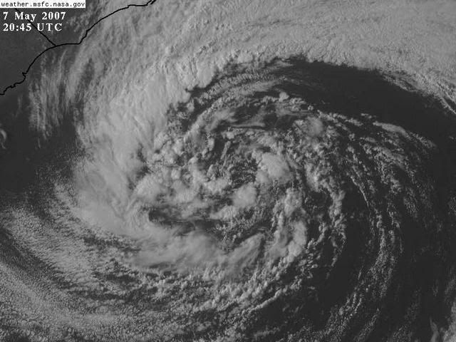
Look how convection is beginning to develop over the eastern simicircle. Lets give this another 12 to 24 hours and final conclusions could be made then.
Look how convection is beginning to develop over the eastern simicircle. Lets give this another 12 to 24 hours and final conclusions could be made then.
0 likes
-
cycloneye

- Admin

- Posts: 149276
- Age: 69
- Joined: Thu Oct 10, 2002 10:54 am
- Location: San Juan, Puerto Rico
Coastal Carolina storm
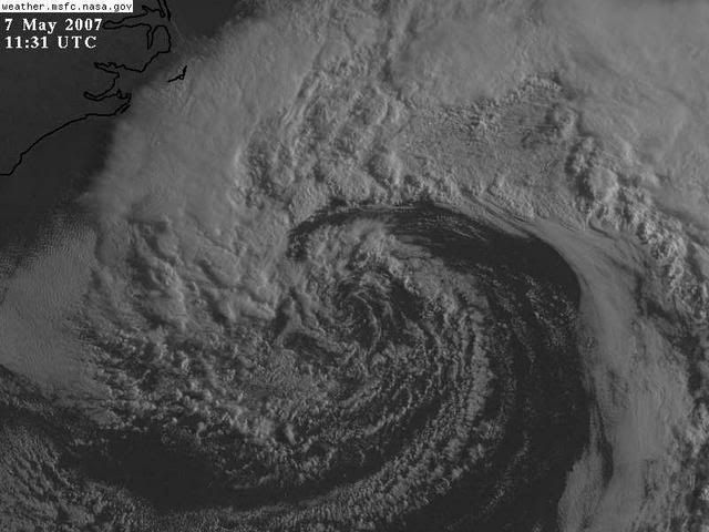
A powerful non-tropical low pressure system formed off the coast of North Carolina last night, and is bringing tropical storm-force winds as high as 55 mph to the waters offshore the Carolina coast, according to the latest QuikSCAT satellite wind estimates. The North Carolina Diamond Shoals buoy had 17 foot seas and sustained winds of 43 mph at 9am EDT this morning, and buoy 41001 about 175 miles east of Cape Hatteras recorded sustained winds of 62 mph gusting to 80 mph at 1am this morning. Seas were 41 feet at this buoy this morning! The strong winds will bring 10-20 foot seas and significant beach erosion to the shores of North Carolina, South Carolina, and northeast Florida through Wednesday. A 3-5 foot storm surge is expected along portions of the North Carolina coast through Tuesday morning. The latest set of computer model runs have the storm drifting slowly southwest, and bring it ashore between the South Carolina and northern Florida coast on Wednesday. The storm will start to develop thunderstorm activity and a warm core, but will probably not have time to become fully subtropical and become Subtropical Storm Andrea. However, the storm is only expected to weaken slowly, and will have an impact similar to a tropical storm in regards to offshore winds and coastal flooding today and Tuesday. If the storm does indeed make landfall on Wednesday as expected, it will most likely be of tropical depression strength, with top sustained winds around 30-35 mph. Heavy rains of 1-3 inches can be expected to the north of where the center makes landfall, but rains will not be as significant as what a tropical storm would bring.
Jeff Masters
The above is an analysis from Jeff Masters of Weather Underground site.
Last edited by cycloneye on Mon May 07, 2007 4:32 pm, edited 2 times in total.
0 likes
Visit the Caribbean-Central America Weather Thread where you can find at first post web cams,radars
and observations from Caribbean basin members Click Here
and observations from Caribbean basin members Click Here
-
feederband
- S2K Supporter
- Posts: 3423
- Joined: Wed Oct 01, 2003 6:21 pm
- Location: Lakeland Fl
http://www.ssd.noaa.gov/goes/flt/t4/loop-vis.html
See the 2 fires blowing up in GA and Fl...Winds must be a big problem right now...
See the 2 fires blowing up in GA and Fl...Winds must be a big problem right now...
0 likes
-
Cryomaniac
- Category 5
- Posts: 1289
- Joined: Tue Aug 15, 2006 2:26 pm
- Location: Newark, Nottinghamshire, UK
- Contact:
-
AnnularCane

- S2K Supporter
- Posts: 2957
- Joined: Thu Jun 08, 2006 9:18 am
- Location: Wytheville, VA
-
SouthFloridawx

- S2K Supporter
- Posts: 8346
- Age: 47
- Joined: Tue Jul 26, 2005 1:16 am
- Location: Sarasota, FL
- Contact:
They are calling it a Sub-Tropical System on the Floater Page.
http://www.ssd.noaa.gov/PS/TROP/float4.html
http://www.ssd.noaa.gov/PS/TROP/float4.html
0 likes
-
Matt-hurricanewatcher
-
HURAKAN
- Professional-Met
- Posts: 46084
- Age: 39
- Joined: Thu May 20, 2004 4:34 pm
- Location: Key West, FL
- Contact:
AnnularCane wrote:Cryomaniac wrote:HURAKAN wrote:INTERNAL CHANGES ARE OCCURRING.
For some unknown reason that made me laugh my head off.
Is she starting to go through puberty?
(I know I shouldn't call this "she" since it's not even an invest yet. I can't help it.)
It's blossoming. So, it's an internal change!!!
0 likes
-
Tampa Bay Hurricane

- Category 5
- Posts: 5597
- Age: 38
- Joined: Fri Jul 22, 2005 7:54 pm
- Location: St. Petersburg, FL
-
Matt-hurricanewatcher
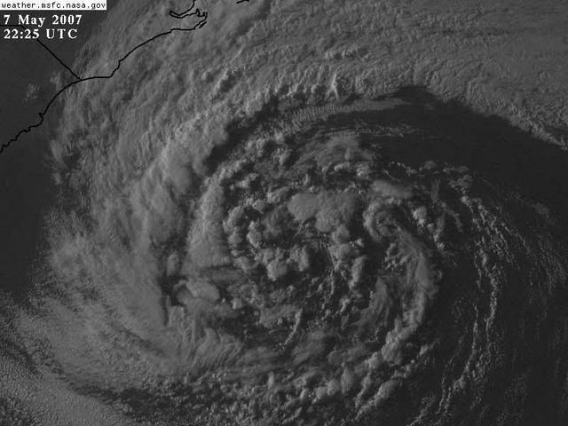
It is starting to develop a low level cirulation,,,Which tells me it is becoming much more tropical, it really doe's remind me of a subtropical system, while looking at those visibles. As the frontal system breaks off over the next 12 hours; we should expect the wind field to tighten, also it to develop a soild "Cdo" like convection over its center. But on the other hand, the wind shear as it becomes warm core, should start having some real effects on it. So this should not become any more then subtropical. This doe's remind me of a few subtropical storms.
0 likes
Who is online
Users browsing this forum: No registered users and 207 guests