November Surprise, tropical style, if some of the stronger and more of an impact that is being forecasted from the models, come close to fruition....
Now really need to do the old adage of '...should closely monitor the progress of the system.'
Possible Development Near the GA/Bahamas (Is Invest 98L)
Moderator: S2k Moderators
Forum rules

The posts in this forum are NOT official forecasts and should not be used as such. They are just the opinion of the poster and may or may not be backed by sound meteorological data. They are NOT endorsed by any professional institution or STORM2K. For official information, please refer to products from the National Hurricane Center and National Weather Service.
-
jaxfladude
- Category 5

- Posts: 1249
- Joined: Wed Aug 24, 2005 9:36 pm
- Location: Jacksonville, Fla
-
eastcoastFL

- Category 5
- Posts: 3996
- Age: 44
- Joined: Thu Apr 12, 2007 12:29 pm
- Location: Palm City, FL
Re: Possible Development Near the GA/Bahamas (50/80)
AxaltaRacing24 wrote:eastcoastFL wrote:Guess I’ll hit the stores in the morning and grab some water just incase before the mobs do when it hits the news. This is kinda nuts, a November east coast hurricane threat. I’m shocked this isn’t an invest yet, especially with the model support.
Kinda nuts? This doesn't feel real lol
lol, not at all. I hope it’s not real. I was kinda settled into the feeling that we dodged an east coast storm for the season again. Now we’re what 3 or 4 days out with models pointing at the coast?
1 likes
Personal Forecast Disclaimer:
The posts in this forum are NOT official forecast and should not be used as such. They are just the opinion of the poster and may or may not be backed by sound meteorological data. They are NOT endorsed by any professional institution or storm2k.org. For official information, please refer to the NHC and NWS products.
The posts in this forum are NOT official forecast and should not be used as such. They are just the opinion of the poster and may or may not be backed by sound meteorological data. They are NOT endorsed by any professional institution or storm2k.org. For official information, please refer to the NHC and NWS products.
-
AdamFirst

- S2K Supporter

- Posts: 2490
- Age: 36
- Joined: Thu Aug 14, 2008 10:54 am
- Location: Port Saint Lucie, FL
Re: Possible Development Near the GA/Bahamas (50/80)
I wonder how good snow birds are with hurricane prep. They may need to do some...
0 likes
Dolphins Marlins Canes Golden Panthers HEAT
Andrew 1992 - Irene 1999 - Frances 2004 - Jeanne 2004 - Wilma 2005 - Fay 2008 - Isaac 2012 - Matthew 2016 - Irma 2017 - Dorian 2019 - Ian 2022 - Nicole 2022 - Milton 2024
Andrew 1992 - Irene 1999 - Frances 2004 - Jeanne 2004 - Wilma 2005 - Fay 2008 - Isaac 2012 - Matthew 2016 - Irma 2017 - Dorian 2019 - Ian 2022 - Nicole 2022 - Milton 2024
-
AdamFirst
- S2K Supporter
- Posts: 2490
- Age: 36
- Joined: Thu Aug 14, 2008 10:54 am
- Location: Port Saint Lucie, FL
Re: Possible Development Near the GA/Bahamas (50/80)
Just as an FYI since daylight savings time is now over, model runs now come in an hour earlier (4:30 AM for 6z GFS rather than 5:30, etc)
06z ICON comes into the peninsula further south as a hurricane into Indian River-Brevard County. 06z GFS is currently running.
06z ICON comes into the peninsula further south as a hurricane into Indian River-Brevard County. 06z GFS is currently running.
2 likes
Dolphins Marlins Canes Golden Panthers HEAT
Andrew 1992 - Irene 1999 - Frances 2004 - Jeanne 2004 - Wilma 2005 - Fay 2008 - Isaac 2012 - Matthew 2016 - Irma 2017 - Dorian 2019 - Ian 2022 - Nicole 2022 - Milton 2024
Andrew 1992 - Irene 1999 - Frances 2004 - Jeanne 2004 - Wilma 2005 - Fay 2008 - Isaac 2012 - Matthew 2016 - Irma 2017 - Dorian 2019 - Ian 2022 - Nicole 2022 - Milton 2024

Re: Possible Development Near the GA/Bahamas (50/80)
Already sucking up a ton of juice.
https://tropic.ssec.wisc.edu/real-time/ ... anim=html5
Models are right, when this stacks, it'll ramp up quickly.
https://tropic.ssec.wisc.edu/real-time/ ... anim=html5
Models are right, when this stacks, it'll ramp up quickly.
0 likes


-
AdamFirst
- S2K Supporter
- Posts: 2490
- Age: 36
- Joined: Thu Aug 14, 2008 10:54 am
- Location: Port Saint Lucie, FL
Re: Possible Development Near the GA/Bahamas (50/80)
Latest NWS Melbourne discussion
Wednesday-Thursday...Though a reasonable amount of uncertainty
remains in the forecast from this period forward, models are coming
to similar solutions that warrant serious attention from mid to
late week. By sunrise Wednesday, a strong subtropical or tropical
system will be picking up speed and some intensity as it moves
southwestward toward the northern Bahamas. The first outer rain
bands may send gusty squalls to the Treasure Coast Wednesday
morning, followed by an expansion to the Space Coast in the
afternoon. Coincidentally, WPC QPF quickly increases across east
central Florida, especially east of Orlando. The next jog the
system looks to take is one to the northwest, and timing this is a
challenge. Models suggest a turn to the west-northwest Wednesday
afternoon and evening with the low ejecting out of the Bahamas
toward the Florida east coast early Thursday morning. EURO model
guidance is faster, taking a more southward trajectory. The GFS
lies in the middle of the guidance envelope with the system
crossing the Florida Peninsula, from the Treasure Coast and up the
spine of the Peninsula. The 00z Canadian is the slowest of the
mentioned three, with the low center approaching the Space Coast
Thursday afternoon as it turns northward, paralleling the Florida
east coast. All that said, any one of these solutions will be
impactful to east central Florida in the form of wind, rainfall,
and dangerous beach/marine conditions. Depending on the low
strength and track, significant rainfall and increased flooding
concerns may also unfold.
With the understanding that many people are still dealing with the
devastating effects of Hurricane Ian, this makes it even more
imperative that attention be paid to the latest forecast for
development and progression of this system through next week.
0 likes
Dolphins Marlins Canes Golden Panthers HEAT
Andrew 1992 - Irene 1999 - Frances 2004 - Jeanne 2004 - Wilma 2005 - Fay 2008 - Isaac 2012 - Matthew 2016 - Irma 2017 - Dorian 2019 - Ian 2022 - Nicole 2022 - Milton 2024
Andrew 1992 - Irene 1999 - Frances 2004 - Jeanne 2004 - Wilma 2005 - Fay 2008 - Isaac 2012 - Matthew 2016 - Irma 2017 - Dorian 2019 - Ian 2022 - Nicole 2022 - Milton 2024
Re: Possible Development Near the GA/Bahamas (50/80)
Huge Great-Lakes Low is forecast to develop by the time this moves over FL.
Front will pull this on a NE track.
The whole East Coast could get raked by this as it transitions and spreads out.
Front will pull this on a NE track.
The whole East Coast could get raked by this as it transitions and spreads out.
0 likes
-
cycloneye

- Admin

- Posts: 149565
- Age: 69
- Joined: Thu Oct 10, 2002 10:54 am
- Location: San Juan, Puerto Rico
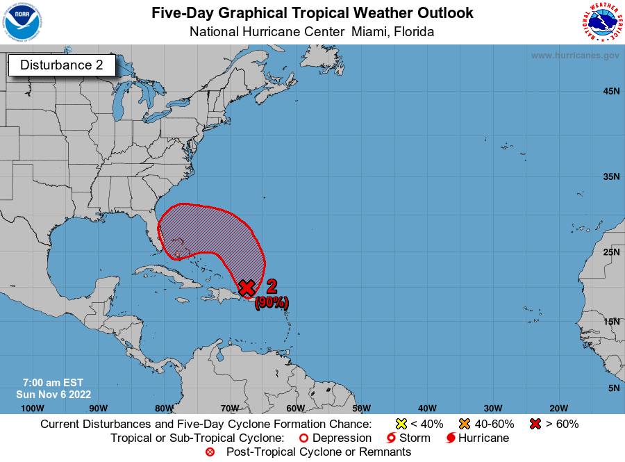
Re: Possible Development Near the GA/Bahamas (70/90)
7 AM TWO up to 70%/90%.

Southwestern Atlantic:
An area of low pressure is developing about 100 miles north of
Puerto Rico and is producing a large area of disorganized showers
and thunderstorms. This system is forecast to move northward or
northwestward further into the southwestern Atlantic today and
environmental conditions appear generally conducive for additional
development. A subtropical or tropical depression is likely to form
early this week while the system turns westward or
west-southwestward over the southwestern Atlantic. Regardless of
development, there is an increasing risk of coastal flooding,
gale-force winds, heavy rainfall, rough surf, and beach erosion
along much of the southeastern United States coast, the Florida east
coast, and portions of the central and northwestern Bahamas during
the early to middle part of this week. Interests in those areas
should continue to monitor the progress of this system.
* Formation chance through 48 hours...high...70 percent.
* Formation chance through 5 days...high...90 percent.
0 likes
Visit the Caribbean-Central America Weather Thread where you can find at first post web cams,radars
and observations from Caribbean basin members Click Here
and observations from Caribbean basin members Click Here
-
SFLcane

- S2K Supporter
- Posts: 10281
- Age: 48
- Joined: Sat Jun 05, 2010 1:44 pm
- Location: Lake Worth Florida
Re: Possible Development Near the GA/Bahamas (70/90)
People are thinking of Thanksgiving not a possible hurricane threat. Worrisome if you ask me for SFL preps if needed
0 likes

Re: Possible Development Near the GA/Bahamas (70/90)
Center might be near 21.25 N -67 E moving NNW but IR imagery is still strange brew and track is going to be kind of weird with the ridge capture. When they do upgrade to invest it might have to be with warnings for Dade. Wouldn't want to have to make that call now? Forecaster Manuelschütz
0 likes
Re: Possible Development Near the GA/Bahamas (70/90)
ML WV imagery shows a dry-air intrusion running thru the Mona passage.
However, the infeed from the EPAC is firing off expanding convection.
Looks like this will spread out during the day and pinch off the dry-air intrusion.
This could then kick in a strong feeder band and convection would then significantly increase.
Watching how this evolves today north of Hispaniola.
0 likes
Re: Possible Development Near the GA/Bahamas (70/90)
06z GEFS seems to say that whatever happens it is almost certainly Florida-bound. Only 3 members or so manage to miss Florida. Pretty crazy for a November storm.

0 likes


Re: Possible Development Near the GA/Bahamas (70/90)
gatorcane wrote:00Z Euro track with 10m winds.
https://i.postimg.cc/85B25qzn/ecmwf-mslp-wind-us-fh0-135.gif
Yet another setup that allows strengthening all the way up to landfall, ugh.
0 likes
-
jlauderdal
- S2K Supporter
- Posts: 7240
- Joined: Wed May 19, 2004 5:46 am
- Location: NE Fort Lauderdale
- Contact:
Re: Possible Development Near the GA/Bahamas (70/90)
Nimbus wrote: Center might be near 21.25 N -67 E moving NNW but IR imagery is still strange brew and track is going to be kind of weird with the ridge capture. When they do upgrade to invest it might have to be with warnings for Dade. Wouldn't want to have to make that call now? Forecaster Manuelschütz
Kate is a good analog to this system. None of this is a big surprise to me, I posted a couple of months ago that with the late start this season could easily go late, I didn't think it would come from the east. 40 gallons of Ian gas still in the garage( I have put 10 in the car already). I'm preparing for 10 days of no juice, 7 days is closer to reality in a worst-case scenario with this storm. Today(especially sunday morning) is the day to get your supplies unless you like waiting in lines. King Tides return today so that is a big issue, especially for Downtown Miami and Hollywood in Sofla that flood on a sunny day during king tide. I'm at 6.2 feet, there is a coastal ridge and I am on it
1 likes
Re: Possible Development Near the GA/Bahamas (70/90)
Buoy 41043, north of PR
Looking close to TD conditions
https://www.ndbc.noaa.gov/show_plot.php ... _label=AST
Looking close to TD conditions
https://www.ndbc.noaa.gov/show_plot.php ... _label=AST
0 likes
-
jlauderdal
- S2K Supporter
- Posts: 7240
- Joined: Wed May 19, 2004 5:46 am
- Location: NE Fort Lauderdale
- Contact:
Re: Possible Development Near the GA/Bahamas (70/90)
gatorcane wrote:00Z Euro track with 10m winds.
https://i.postimg.cc/85B25qzn/ecmwf-mslp-wind-us-fh0-135.gif
The euro is down 10 MB from two days ago, the 10 isn't as important as the trend....Key West(their preps today are more drinks) to Daytona Beach; prepare for a 2. FYI, Bastardi nailed this setup a couple of weeks ago...call it what you want, but its a win.
0 likes
-
toad strangler

- S2K Supporter
- Posts: 4546
- Joined: Sun Jul 28, 2013 3:09 pm
- Location: Earth
- Contact:
Re: Possible Development Near the GA/Bahamas (70/90)
Morgerman says no. But one thing he AINT is a forecaster lol.
http://twitter.com/icyclone/status/1589141896152375299
http://twitter.com/icyclone/status/1588953164249604096
http://twitter.com/icyclone/status/1589141896152375299
http://twitter.com/icyclone/status/1588953164249604096
0 likes
My Weather Station
https://www.wunderground.com/dashboard/pws/KFLPORTS603
https://www.wunderground.com/dashboard/pws/KFLPORTS603
-
jlauderdal
- S2K Supporter
- Posts: 7240
- Joined: Wed May 19, 2004 5:46 am
- Location: NE Fort Lauderdale
- Contact:
Re: Possible Development Near the GA/Bahamas (70/90)
toad strangler wrote:Morgerman says no. But one thing he AINT is a forecaster lol.
http://twitter.com/icyclone/status/1589141896152375299?s=46&t=_q6Uf3-YQiWfJhLKZuX4vA
http://twitter.com/icyclone/status/1588953164249604096?s=46&t=_q6Uf3-YQiWfJhLKZuX4vA
He might downplay it on twitter but you can be assured he gets excited at the mere thought of a thunderstorm complex in the Atlantic basin, his livelihood depends on it.
2 likes
Who is online
Users browsing this forum: gib and 105 guests