Analysis,Models,Sat Pics of Low in Western Atlantic
Moderator: S2k Moderators
Forum rules

The posts in this forum are NOT official forecasts and should not be used as such. They are just the opinion of the poster and may or may not be backed by sound meteorological data. They are NOT endorsed by any professional institution or STORM2K. For official information, please refer to products from the National Hurricane Center and National Weather Service.
-
eastcoastFL

- Category 5

- Posts: 3996
- Age: 44
- Joined: Thu Apr 12, 2007 12:29 pm
- Location: Palm City, FL
it actually looks like its starting to wrap around the center a bit
0 likes
Personal Forecast Disclaimer:
The posts in this forum are NOT official forecast and should not be used as such. They are just the opinion of the poster and may or may not be backed by sound meteorological data. They are NOT endorsed by any professional institution or storm2k.org. For official information, please refer to the NHC and NWS products.
The posts in this forum are NOT official forecast and should not be used as such. They are just the opinion of the poster and may or may not be backed by sound meteorological data. They are NOT endorsed by any professional institution or storm2k.org. For official information, please refer to the NHC and NWS products.
-
seahawkjd
- S2K Supporter

- Posts: 632
- Joined: Wed Sep 10, 2003 4:12 pm
- Location: Morehead City, NC
- Contact:
Its definetely starting to throw a little rain our way. Its been very windy all day, there are starting to be issues with flooding. I also know they were pulling people out of 35+ foot seas off the cost. Strongest gusts so far have been 60+ mph. So, its basically been a tropical storm minus the rain for the past 24 hours.
0 likes

-
Coredesat


-
MusicCityMan

- Category 1

- Posts: 483
- Joined: Sat Feb 17, 2007 10:57 pm
- Location: Somewhere in Central Florida
Too bad the dry air just cant cease 4 a bit.. GA and FLA need tons of rain.. and with a potential big rain maker this close.. It's almost like mom nature is playing a cruel joke by not letting it grow some.. even if it just became an STD {sub tropical depression lol not the other thing ur thinking} or an STS, the rain would be appreciated,
The severe weather we got yesterday was just a drop in the bucket really. BRING ON THE RAIN and THE START OF THE 2007 SEASON lol
lol
The severe weather we got yesterday was just a drop in the bucket really. BRING ON THE RAIN and THE START OF THE 2007 SEASON
0 likes
-
Matt-hurricanewatcher
-
brunota2003

- S2K Supporter
- Posts: 9476
- Age: 35
- Joined: Sat Jul 30, 2005 9:56 pm
- Location: Stanton, KY...formerly Havelock, NC
- Contact:
Yep, Coast Guard C-130 landed earlier here at Cherry Point, they probably refueled and went back out.seahawkjd wrote:Its definetely starting to throw a little rain our way. Its been very windy all day, there are starting to be issues with flooding. I also know they were pulling people out of 35+ foot seas off the cost. Strongest gusts so far have been 60+ mph. So, its basically been a tropical storm minus the rain for the past 24 hours.
0 likes

TPC forecasts the low pressure to be near JAX in 48 hours as a weaker 1010 mb circulation. By 72 hrs, it fills to an open trough over the FL peninsula. Right now, based on the model forecasts, I don't see this storm becoming subtropical storm Andrea - just not enough time over maginally warm sea temps. However, I do believe the local NWS offfices are being really conservative in there precip forecasts because even if this thing does weaken and flatten out over FL we should get some pretty heavy downpours by the advection of moisture and day time heating. I am a bit surprised by the available moisture on the west side of this storm - I thought everything would be asymmetrically tilted toward the north and east sides. The convection does seem to be increasing this evening near the center as the system slowly progresses toward the gulf stream.
http://www.nhc.noaa.gov/tafb_latest/atl ... testBW.gif
http://www.nhc.noaa.gov/tafb_latest/atl ... testBW.gif
0 likes
-
brunota2003
- S2K Supporter
- Posts: 9476
- Age: 35
- Joined: Sat Jul 30, 2005 9:56 pm
- Location: Stanton, KY...formerly Havelock, NC
- Contact:
-
cycloneye

- Admin

- Posts: 149276
- Age: 69
- Joined: Thu Oct 10, 2002 10:54 am
- Location: San Juan, Puerto Rico
WESTERN ATLANTIC...
THE HIGHLIGHT CONTINUES TO BE A LARGE OCCLUDED LOW PRES SYSTEM
CENTERED OFF THE SE U.S. NEAR 31N75W...ANALYZED 998 MB. A
TRAILING/BACK DOOR COLD FRONT EXTENDS FROM A TRIPLE POINT NEAR
32N67W ACROSS THE CENTRAL BAHAMAS...NRN CUBA AND THEN INTO THE
GULF OF MEXICO. A STATIONARY FRONT RUNS FROM THE TRIPLE POINT TO
52W ALONG 32N WITH TWO WEAK FRONTAL WAVES. THIS LOW PRES SYSTEM
HAS AN IMPRESSIVELY LARGE CIRCULATION BUT NOT MUCH DEEP
MOISTURE...ESPECIALLY ON ITS S SIDE. ISOLATED SHOWERS ARE WITHIN
180 NM E OF THE FRONT AND BASICALLY ANYWHERE BETWEEN 50W AND THE
FRONT ENHANCED BY UPPER SWLY FLOW. HOWEVER...WHAT IT IS
PRODUCING IS VERY STRONG WINDS AS A VERY TIGHT PRES GRADIENT HAS
SET UP BETWEEN THE LOW AND A STRONG HIGH PRES RIDGE OVER AND OFF
THE NE U.S. COASTLINE. THIS PRES GRADIENT IS PRODUCING HURRICANE
FORCE WINDS N OF THE AREA E OF THE CAROLINA COASTLINE AND STORM
FORCE CONDITIONS IN OUR AREA N OF 28N W OF 74W. SEVERAL
ADVISORIES AND WARNINGS HAVE BEEN POSTED ALONG THE COAST FROM
SOUTH FLORIDA TO BEYOND THE CAROLINAS WHERE ROUGH SURF AND VERY
DANGEROUS RIP CURRENTS ARE LIKELY OCCURRING. GLOBAL MODELS ARE
IN GOOD AGREEMENT TRACKING THE LOW WWD TOWARD THE SE COAST BUT
THERE ARE DIFFERENCES IN SPEED/TIMING. THE CURRENT FORECAST
CALLS FOR WINDS TO BEGIN SLOWLY SUBSIDING...AS THE GRADIENT
SLACKENS... FALLING BELOW GALE FORCE IN ABOUT 36 HOURS.
http://www.storm2k.org/wx/modules.php?n ... ge&pid=109
The above is from the 8 PM discussion from TPC.Not a word from them about any turning from cold to warm core.
0 likes
Visit the Caribbean-Central America Weather Thread where you can find at first post web cams,radars
and observations from Caribbean basin members Click Here
and observations from Caribbean basin members Click Here
-
MusicCityMan
- Category 1
- Posts: 483
- Joined: Sat Feb 17, 2007 10:57 pm
- Location: Somewhere in Central Florida
-
cycloneye
- Admin
- Posts: 149276
- Age: 69
- Joined: Thu Oct 10, 2002 10:54 am
- Location: San Juan, Puerto Rico
DATE/TIME LAT LON CLASSIFICATION STORM
07/2345 UTC 30.9N 74.7W ST2.5/2.5 90L -- Atlantic Ocean
07/1745 UTC 31.6N 73.9W ST2.5/2.5 90L -- Atlantic Ocean
07/1145 UTC 32.0N 73.1W ST2.5/2.5 90L -- Atlantic Ocean
07/0545 UTC 33.3N 72.5W ST2.5/2.5 90L -- Atlantic Ocean
http://www.ssd.noaa.gov/PS/TROP/positions.html
The first line of numbers that is separated from the others is the very latest one from this evening at 23:45 UTC.As you can see from the positions the low has been moving WSW but by that latest position the movement is more West to Westsouthwestward.
0 likes
-
'CaneFreak

- Category 5
- Posts: 1487
- Joined: Mon Jun 05, 2006 10:50 am
- Location: New Bern, NC
NDG wrote:'CaneFreak wrote:We don't have a wanna be Andrea going on....for anyone who says tropical cyclone formation is possible....I hate to break the bad news...but, SSTs are WELL BELOW 80 degrees where this thing is sitting...so unfortunately...this thing will not make it to tropical characteristics....even if it creeps into the Gulf...SSTs in the gulf are barely sustainable for anything to develop....this thing MAY make it to subtropical...but I really and truly dont think it will for various reasons.
I don't think anybody has said that it will gain subtropical charecteristics where it is sitting right now, the possibilities come once it moves closer and over the gulf stream where SST are close to 80 deg. Even upper 70s are good enough for a subtropical system to form, it has happened many times over the Atlantic. I think the killer would be if it moves westward a lot faster through the warmer waters thus sucking some of the dry air coming down the Carolinas coast.
By the way here's a more accurate SST map than the one you posted, I posted this earlier today, I pointed out areas where water temps are close to 80 deg F.
Dr. Steve Lyons was just on the TWC and his SST graphic conflicted with the SST graphic you posted. Maybe it is a resolution thing? I don't know, but I thought you should know. The map I posted is accurate afterall....For those of you on the subtropical bandwagon, it is not going to have time. But, that does not mean it will not bring you some rain. It can still bring you some rain without ever becoming subtropical
0 likes
-
wxman57

- Moderator-Pro Met

- Posts: 23172
- Age: 68
- Joined: Sat Jun 21, 2003 8:06 pm
- Location: Houston, TX (southwest)
Matt-hurricanewatcher wrote:It is starting to develop a low level cirulation,,,Which tells me it is becoming much more tropical, it really doe's remind me of a subtropical system, while looking at those visibles. As the frontal system breaks off over the next 12 hours; we should expect the wind field to tighten, also it to develop a soild "Cdo" like convection over its center. But on the other hand, the wind shear as it becomes warm core, should start having some real effects on it. So this should not become any more then subtropical. This doe's remind me of a few subtropical storms.
Actually, it's had a well-defined LLC since last night. All surface low pressure systems have LLCs, but that doesn't make them all tropical cyclones. It's present appearance is that of a weakening surface reflection of an occluded low. With the high center moving off to the east, the pressure gradient to its north will gradually diminish over the next 24 hours., as will wind shear aloft. Such systems can transition to warm-core lows, but the process can take a number of days. This low only has about 48 hours left over water. With marginal SSTs, it'll most likely continue to spin down until it moves ashore Wednesday evening.
0 likes
-
wxman57
- Moderator-Pro Met
- Posts: 23172
- Age: 68
- Joined: Sat Jun 21, 2003 8:06 pm
- Location: Houston, TX (southwest)
'CaneFreak wrote:
Dr. Steve Lyons was just on the TWC and his SST graphic conflicted with the SST graphic you posted. Maybe it is a resolution thing? I don't know, but I thought you should know. The map I posted is accurate afterall....For those of you on the subtropical bandwagon, it is not going to have time. But, that does not mean it will not bring you some rain. It can still bring you some rain without ever becoming subtropical
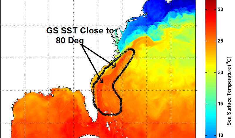
Here's another higher-resolution SST graphic. Temps across the Gulf stream are in the 79-80 degree range over a narrow band, with much cooler water all around. With so much cool dry air around the low, chances of warm-core transition are very low.

0 likes
-
HurricaneHunter914
- Category 5
- Posts: 4439
- Age: 32
- Joined: Fri Mar 10, 2006 7:36 pm
- Location: College Station, TX
http://www.ssd.noaa.gov/goes/flt/t4/avn.jpg
It's still lacking convection in the center, but it still looks great. Might be an invest by tomorrow if it looks better organized.
It's still lacking convection in the center, but it still looks great. Might be an invest by tomorrow if it looks better organized.
0 likes
Personal Forecast Disclaimer:
The posts in this forum are NOT official forecast and should not be used as such. They are just the opinion of the poster and may or may not be backed by sound meteorological data. They are NOT endorsed by any professional institution or storm2k.org. For official information, please refer to the NHC and NWS products.
The posts in this forum are NOT official forecast and should not be used as such. They are just the opinion of the poster and may or may not be backed by sound meteorological data. They are NOT endorsed by any professional institution or storm2k.org. For official information, please refer to the NHC and NWS products.

Who is online
Users browsing this forum: No registered users and 221 guests