
Low Pressure in the NW Caribbean/SE GOM: 1006mb
Moderator: S2k Moderators
Forum rules

The posts in this forum are NOT official forecasts and should not be used as such. They are just the opinion of the poster and may or may not be backed by sound meteorological data. They are NOT endorsed by any professional institution or STORM2K. For official information, please refer to products from the National Hurricane Center and National Weather Service.
-
Extremeweatherguy

- Category 5

- Posts: 11095
- Joined: Mon Oct 10, 2005 8:13 pm
- Location: Florida


-
'CaneFreak

- Category 5
- Posts: 1487
- Joined: Mon Jun 05, 2006 10:50 am
- Location: New Bern, NC
http://www.ssd.noaa.gov/goes/east/watl/avn-l.jpg
Who said poof? I see convection firing. Still bears watching.
Who said poof? I see convection firing. Still bears watching.
0 likes
-
Opal storm
-
windstorm99

- S2K Supporter

- Posts: 1578
- Age: 48
- Joined: Sat May 26, 2007 8:10 am
- Location: Miami, Florida
- Contact:
-
Aric Dunn
- Category 5
- Posts: 21238
- Age: 43
- Joined: Sun Sep 19, 2004 9:58 pm
- Location: Ready for the Chase.
- Contact:
there is a surface low forming near roatan island just off shore hondorous
out of all the mess over the past few days this mess!! has the most promise... it has the the strongest low level cuvature and a better pressure field .. there is a ship right near swan island with a pressure of 1007 mb.
and there is a small upper anti cyclone almost over it .. but very hostile as you enter into the gulf ....
reminds me of alberto last year .. almost the exact set up
Last edited by Aric Dunn on Wed May 30, 2007 11:40 pm, edited 3 times in total.
0 likes
-
wxman57

- Moderator-Pro Met

- Posts: 23175
- Age: 68
- Joined: Sat Jun 21, 2003 8:06 pm
- Location: Houston, TX (southwest)
You're looking in the wrong area. Look farther north in the NW Caribbean to the southern Gulf for this disturbance. Moisture will be streaming northward into an upper trof/low across the north-central Gulf over the next 24-48 hours. That's where the low may form. But it'll be in a high shear environment, more of a hybrid low. Probably sub-TS force winds. Beneficial rain for Florida though, possibly. May not be organized enough for NHC to worry about it, but wouldn't rule a TD or STD out.
0 likes
-
Aric Dunn
- Category 5
- Posts: 21238
- Age: 43
- Joined: Sun Sep 19, 2004 9:58 pm
- Location: Ready for the Chase.
- Contact:
wxman57 wrote:You're looking in the wrong area. Look farther north in the southern Gulf for this disturbance. Moisture will be streaming northward into an upper trof/low across the north-central Gulf over the next 24-48 hours. That's where the low may form. But it'll be in a high shear environment, more of a hybrid low. Probably sub-TS force winds. Beneficial rain for Florida though, possibly. May not be organized enough for NHC to worry about it, but wouldn't rule a TD or STD out.
rather not... there is nothing there .... easterlies blowing straight thru it ...
http://www.ssd.noaa.gov/goes/flt/t2/loop-ir2.html
0 likes

wxman57 wrote:You're looking in the wrong area. Look farther north in the NW Caribbean to the southern Gulf for this disturbance. Moisture will be streaming northward into an upper trof/low across the north-central Gulf over the next 24-48 hours. That's where the low may form. But it'll be in a high shear environment, more of a hybrid low. Probably sub-TS force winds. Beneficial rain for Florida though, possibly. May not be organized enough for NHC to worry about it, but wouldn't rule a TD or STD out.
Euro seems to agree with you or viceversa.
Seriously, I think the euro is right on the money for right now.
0 likes
-
windstorm99
- S2K Supporter
- Posts: 1578
- Age: 48
- Joined: Sat May 26, 2007 8:10 am
- Location: Miami, Florida
- Contact:

-
Aric Dunn
- Category 5
- Posts: 21238
- Age: 43
- Joined: Sun Sep 19, 2004 9:58 pm
- Location: Ready for the Chase.
- Contact:
Aric Dunn wrote:wxman57 wrote:You're looking in the wrong area. Look farther north in the southern Gulf for this disturbance. Moisture will be streaming northward into an upper trof/low across the north-central Gulf over the next 24-48 hours. That's where the low may form. But it'll be in a high shear environment, more of a hybrid low. Probably sub-TS force winds. Beneficial rain for Florida though, possibly. May not be organized enough for NHC to worry about it, but wouldn't rule a TD or STD out.
rather not... there is nothing there .... easterlies blowing straight thru it ...
http://www.ssd.noaa.gov/goes/flt/t2/loop-ir2.html
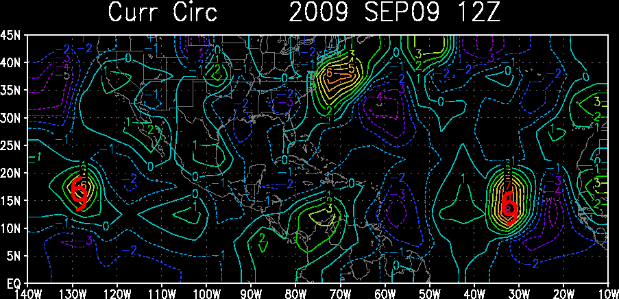
oh wait maybe this will help you see where the low is forming as i said
http://www.ssd.noaa.gov/PS/TROP/DATA/gparm/xyrcir.gif
I have also found some south and Sw winds on the honduras coast http://weather.noaa.gov/weather/HN_cc.html
also the island roatan and the one next to it ( quanaja to its east) have North and then SW
so the Low is and has been trying to get going in that area all day
0 likes

Aric Dunn wrote:Aric Dunn wrote:wxman57 wrote:You're looking in the wrong area. Look farther north in the southern Gulf for this disturbance. Moisture will be streaming northward into an upper trof/low across the north-central Gulf over the next 24-48 hours. That's where the low may form. But it'll be in a high shear environment, more of a hybrid low. Probably sub-TS force winds. Beneficial rain for Florida though, possibly. May not be organized enough for NHC to worry about it, but wouldn't rule a TD or STD out.
rather not... there is nothing there .... easterlies blowing straight thru it ...
http://www.ssd.noaa.gov/goes/flt/t2/loop-ir2.html
oh wait maybe this will help you see where the low is forming as i said
http://www.ssd.noaa.gov/PS/TROP/DATA/gparm/xyrcir.gif
I have also found some south and Sw winds on the honduras coast http://weather.noaa.gov/weather/HN_cc.html
also the island roatan and the one next to it ( quanaja to its east) have North and then SW
so the Low is and has been trying to get going in that area all day
How do you read that map with the numbers going from 1to 5 or viceversa.
0 likes

Notice the barometric pressure is dropping at Roatan off Honduras.
http://weather.noaa.gov/weather/current/MHRO.html
http://weather.noaa.gov/weather/current/MHRO.html
0 likes
-
Matt-hurricanewatcher
Gfs,Gfdl develops a low pressure. Both track it from that blob in the western caribbean south of Cuba. This reminds me of Alberto, yes high shear to its north, but overall shear around the system its self is decreasing at 10 knots. Which is another sign...The Cmc shows a fairly organized system; maybe a strong tropical storm/subtropical storm?
0 likes


Who is online
Users browsing this forum: StPeteMike, WaveBreaking and 268 guests