2017 indicators: SST's / MSLP / SAL / Steering / Instability

This is the general tropical discussion area. Anyone can take their shot at predicting a storms path.

Moderator: S2k Moderators

Forum rules

The posts in this forum are NOT official forecasts and should not be used as such. They are just the opinion of the poster and may or may not be backed by sound meteorological data. They are NOT endorsed by any professional institution or STORM2K. For official information, please refer to products from the National Hurricane Center and National Weather Service.

Help Support Storm2K
Message
Author
User avatar
TheStormExpert
Category 5
Category 5
Posts: 8487
Age: 30
Joined: Wed Feb 16, 2011 5:38 pm
Location: Palm Beach Gardens, FL

Re: 2017 indicators: SST's / MSLP / SAL / Steering / Instability

#341 Postby TheStormExpert » Mon May 15, 2017 3:16 pm

Andrew92 wrote:The JB tweet above has me quite concerned when coupled with a theory I have proposed for some time. Some people may know that the theory is the second year following a traditional El Nino has always seen a major hurricane hit the US. A major hurricane in my case is not merely a Category 3 or higher by wind, but instead I go by pressure. The threshold is below 965 mb. 2017 is going to test that theory.

What's more is that El Nino may indeed not be returning as speculated just a month ago or so. I am not going to necessarily say though that 2005 is a solid analog. However, the MDR was not terribly active that year after July (when we had Dennis and Emily) and such a weak MDR would not surprise me again this year. That's because, even without an El Nino, some warming may keep the lower latitudes at bay a little bit. But the subtropics concern me a great deal more. Wasn't there also a lot of talk of potential homegrown activity this year? The Bahamas and Gulf of Mexico fit that bill well, so such activity forming and intensifying in those regions is probably what I would most expect.

I agree there is a lot of uncertainty and mixed signals coming into this hurricane season as well. But the theory of the second year after an El Nino stands to be tested. Everyone should absolutely watch out this year for a big one to potentially hit. (I know that sounds cliche, but this year, based on my theory, is high-risk.) And I should stress, it won't take 2005-like impacts to prove the theory. It will only take one hurricane below 965 mb striking the US coast somewhere for the theory to stand. Just like last time, in 2011, when Irene was the only one, but her pressure was 955 mb at the North Carolina landfall, and she went on to cause a lot of problems and damage in the Northeast.

I hope it's proven wrong, but I would be well-prepared if I lived on the Atlantic coast.

-Andrew92

As long as you've been doing this theory has it proven to be true every single 2nd year proceeding an El Niño?
0 likes   
The following post is NOT an official forecast and should not be used as such. It is just the opinion of the poster and may or may not be backed by sound meteorological data. It is NOT endorsed by storm2k.org.

User avatar
Andrew92
S2K Supporter
S2K Supporter
Posts: 3247
Age: 40
Joined: Mon Jun 16, 2003 12:35 am
Location: Phoenix, Arizona

Re: 2017 indicators: SST's / MSLP / SAL / Steering / Instability

#342 Postby Andrew92 » Mon May 15, 2017 3:41 pm

TheStormExpert wrote:
Andrew92 wrote:The JB tweet above has me quite concerned when coupled with a theory I have proposed for some time. Some people may know that the theory is the second year following a traditional El Nino has always seen a major hurricane hit the US. A major hurricane in my case is not merely a Category 3 or higher by wind, but instead I go by pressure. The threshold is below 965 mb. 2017 is going to test that theory.

What's more is that El Nino may indeed not be returning as speculated just a month ago or so. I am not going to necessarily say though that 2005 is a solid analog. However, the MDR was not terribly active that year after July (when we had Dennis and Emily) and such a weak MDR would not surprise me again this year. That's because, even without an El Nino, some warming may keep the lower latitudes at bay a little bit. But the subtropics concern me a great deal more. Wasn't there also a lot of talk of potential homegrown activity this year? The Bahamas and Gulf of Mexico fit that bill well, so such activity forming and intensifying in those regions is probably what I would most expect.

I agree there is a lot of uncertainty and mixed signals coming into this hurricane season as well. But the theory of the second year after an El Nino stands to be tested. Everyone should absolutely watch out this year for a big one to potentially hit. (I know that sounds cliche, but this year, based on my theory, is high-risk.) And I should stress, it won't take 2005-like impacts to prove the theory. It will only take one hurricane below 965 mb striking the US coast somewhere for the theory to stand. Just like last time, in 2011, when Irene was the only one, but her pressure was 955 mb at the North Carolina landfall, and she went on to cause a lot of problems and damage in the Northeast.

I hope it's proven wrong, but I would be well-prepared if I lived on the Atlantic coast.

-Andrew92

As long as you've been doing this theory has it proven to be true every single 2nd year proceeding an El Niño?


Yes. Every year that is the second year after an El Nino since the 1950s has had at least one such storm. Also every year immediately after a classic Modoki event going back that far.

I haven't gone back farther because I don't completely trust the data and I can't put my finger on when any Modoki versus traditional events were before 1950. The data since then, however, strongly suggests this is a year to be very well-prepared for a big hurricane. Hopefully this year breaks that mold, but get ready just in case.

-Andrew92
4 likes   

User avatar
Hurricaneman
Category 5
Category 5
Posts: 7284
Age: 43
Joined: Tue Aug 31, 2004 3:24 pm
Location: central florida

Re: 2017 indicators: SST's / MSLP / SAL / Steering / Instability

#343 Postby Hurricaneman » Mon May 15, 2017 11:06 pm

I wouldn't be surprised if this season is quite active but 2013 is an example of things looking quite favorable but it was quite the contrary
0 likes   

User avatar
TheStormExpert
Category 5
Category 5
Posts: 8487
Age: 30
Joined: Wed Feb 16, 2011 5:38 pm
Location: Palm Beach Gardens, FL

Re: 2017 indicators: SST's / MSLP / SAL / Steering / Instability

#344 Postby TheStormExpert » Tue May 16, 2017 11:48 am

One thing that's for sure is the Western Caribbean is on it's way to being prime in time for the start of the season in the next few weeks. GFS keeps showing low pressure getting left behind in that region every several days or so but conditions aren't quite ready just yet.
0 likes   
The following post is NOT an official forecast and should not be used as such. It is just the opinion of the poster and may or may not be backed by sound meteorological data. It is NOT endorsed by storm2k.org.

Ntxw
Storm2k Moderator
Storm2k Moderator
Posts: 21565
Joined: Wed Oct 21, 2009 6:34 pm
Location: DFW, Texas

Re: 2017 indicators: SST's / MSLP / SAL / Steering / Instability

#345 Postby Ntxw » Tue May 16, 2017 12:15 pm

Hurricaneman wrote:I wouldn't be surprised if this season is quite active but 2013 is an example of things looking quite favorable but it was quite the contrary


2013 is an example of how everyone can get it wrong using conventional criteria for a season. I think though the risk for an above season is a better likelihood than below. But still emphasize uncertainty.
0 likes   
The above post and any post by Ntxw is NOT an official forecast and should not be used as such. It is just the opinion of the poster and may or may not be backed by sound meteorological data. It is NOT endorsed by any professional institution including Storm2k. For official information, please refer to NWS products.

  Help support Storm2K!
Help Support Storm2K

User avatar
cycloneye
Admin
Admin
Posts: 139596
Age: 67
Joined: Thu Oct 10, 2002 10:54 am
Location: San Juan, Puerto Rico

Re: 2017 indicators: SST's / MSLP / SAL / Steering / Instability

#346 Postby cycloneye » Tue May 16, 2017 12:32 pm

0 likes   
Visit the Caribbean-Central America Weather Thread where you can find at first post web cams,radars
and observations from Caribbean basin members Click Here

User avatar
TheStormExpert
Category 5
Category 5
Posts: 8487
Age: 30
Joined: Wed Feb 16, 2011 5:38 pm
Location: Palm Beach Gardens, FL

Re: 2017 indicators: SST's / MSLP / SAL / Steering / Instability

#347 Postby TheStormExpert » Tue May 16, 2017 12:33 pm

Ntxw wrote:
Hurricaneman wrote:I wouldn't be surprised if this season is quite active but 2013 is an example of things looking quite favorable but it was quite the contrary


2013 is an example of how everyone can get it wrong using conventional criteria for a season. I think though the risk for an above season is a better likelihood than below. But still emphasize uncertainty.

Right now I'd go with a near average to above average season as well. But we definitely can't rule 2013 out yet.
0 likes   
The following post is NOT an official forecast and should not be used as such. It is just the opinion of the poster and may or may not be backed by sound meteorological data. It is NOT endorsed by storm2k.org.

User avatar
Hammy
Category 5
Category 5
Posts: 5594
Age: 40
Joined: Fri May 25, 2012 5:25 pm
Contact:

Re: 2017 indicators: SST's / MSLP / SAL / Steering / Instability

#348 Postby Hammy » Tue May 16, 2017 3:56 pm

TheStormExpert wrote:
Ntxw wrote:
Hurricaneman wrote:I wouldn't be surprised if this season is quite active but 2013 is an example of things looking quite favorable but it was quite the contrary


2013 is an example of how everyone can get it wrong using conventional criteria for a season. I think though the risk for an above season is a better likelihood than below. But still emphasize uncertainty.

Right now I'd go with a near average to above average season as well. But we definitely can't rule 2013 out yet.


There are specific reasons why 2013 was inactive, and it was on a global scale, not just the Atlantic--the thermohaline circulation weakened that year, causing the global weather pattern to remain in spring. I won't rule out a 2013-type season but it's also important to understand why 2013 was inactive to start with.
0 likes   
The above post is not official and should not be used as such. It is the opinion of the poster and may or may not be backed by sound meteorological data. It is not endorsed by any professional institution or storm2k.org. For official information, please refer to the NHC and NWS products.

User avatar
Yellow Evan
Professional-Met
Professional-Met
Posts: 15960
Age: 25
Joined: Fri Jul 15, 2011 12:48 pm
Location: Henderson, Nevada/Honolulu, HI
Contact:

Re: 2017 indicators: SST's / MSLP / SAL / Steering / Instability

#349 Postby Yellow Evan » Tue May 16, 2017 4:02 pm

2013 wasn't inactive on a global scale. NIO and WPAC were very active that year, and the SHEM was near average at worst.
0 likes   

User avatar
Hammy
Category 5
Category 5
Posts: 5594
Age: 40
Joined: Fri May 25, 2012 5:25 pm
Contact:

Re: 2017 indicators: SST's / MSLP / SAL / Steering / Instability

#350 Postby Hammy » Tue May 16, 2017 4:05 pm

Yellow Evan wrote:2013 wasn't inactive on a global scale. NIO and WPAC were very active that year, and the SHEM was near average at worst.


That contradicts what I remember reading here at the time.
0 likes   
The above post is not official and should not be used as such. It is the opinion of the poster and may or may not be backed by sound meteorological data. It is not endorsed by any professional institution or storm2k.org. For official information, please refer to the NHC and NWS products.

Ntxw
Storm2k Moderator
Storm2k Moderator
Posts: 21565
Joined: Wed Oct 21, 2009 6:34 pm
Location: DFW, Texas

Re: 2017 indicators: SST's / MSLP / SAL / Steering / Instability

#351 Postby Ntxw » Tue May 16, 2017 4:15 pm

Hammy wrote:
Yellow Evan wrote:2013 wasn't inactive on a global scale. NIO and WPAC were very active that year, and the SHEM was near average at worst.


That contradicts what I remember reading here at the time.


The Atlantic and EPAC made a dent in the global numbers being low, but the other basins as mentioned above were not inactive. Wpac was busiest and deadliest since 2004, including the most famous Haiyan.
0 likes   
The above post and any post by Ntxw is NOT an official forecast and should not be used as such. It is just the opinion of the poster and may or may not be backed by sound meteorological data. It is NOT endorsed by any professional institution including Storm2k. For official information, please refer to NWS products.


  Help support Storm2K!

Help Support Storm2K


User avatar
Hammy
Category 5
Category 5
Posts: 5594
Age: 40
Joined: Fri May 25, 2012 5:25 pm
Contact:

Re: 2017 indicators: SST's / MSLP / SAL / Steering / Instability

#352 Postby Hammy » Tue May 16, 2017 4:25 pm

Ntxw wrote:
Hammy wrote:
Yellow Evan wrote:2013 wasn't inactive on a global scale. NIO and WPAC were very active that year, and the SHEM was near average at worst.


That contradicts what I remember reading here at the time.


The Atlantic and EPAC made a dent in the global numbers being low, but the other basins as mentioned above were not inactive. Wpac was busiest and deadliest since 2004, including the most famous Haiyan.


I remember Haiyan but thought the basin was largely below normal otherwise.

On the note of 2013, I'm noticing another long period of below normal temperatures on the way in the longer range models--could that indicate the same thing is happening? I know most of 2013 (up until September anyway) was cooler than normal over much of the US.
0 likes   
The above post is not official and should not be used as such. It is the opinion of the poster and may or may not be backed by sound meteorological data. It is not endorsed by any professional institution or storm2k.org. For official information, please refer to the NHC and NWS products.

User avatar
ScottNAtlanta
Category 5
Category 5
Posts: 2014
Joined: Sat May 25, 2013 3:11 pm
Location: Atlanta, GA

Re: 2017 indicators: SST's / MSLP / SAL / Steering / Instability

#353 Postby ScottNAtlanta » Tue May 16, 2017 5:00 pm

As I recall in 2013 there was lots of warm water all over the Atlantic, and as such there was also high pressure over the basin which kept activity low. This year (if it holds out) you have a warm MDR and a cooler anomaly north of that. That encourages low pressure in the MDR. There was no "forcing" mechanism in 2013. Its there now (if it holds)
2 likes   
The posts in this forum are NOT official forecast and should not be used as such. They are just the opinion of the poster and may or may not be backed by sound meteorological data. They are NOT endorsed by any professional institution or storm2k.org. For official information, please refer to the NHC and NWS products.

Ntxw
Storm2k Moderator
Storm2k Moderator
Posts: 21565
Joined: Wed Oct 21, 2009 6:34 pm
Location: DFW, Texas

Re: 2017 indicators: SST's / MSLP / SAL / Steering / Instability

#354 Postby Ntxw » Tue May 16, 2017 7:18 pm

ScottNAtlanta wrote:As I recall in 2013 there was lots of warm water all over the Atlantic, and as such there was also high pressure over the basin which kept activity low. This year (if it holds out) you have a warm MDR and a cooler anomaly north of that. That encourages low pressure in the MDR. There was no "forcing" mechanism in 2013. Its there now (if it holds)


2013 and 2017 on the Atlantic side SST wise is not widely different. Pacific is very different.

Image
Image
3 likes   
The above post and any post by Ntxw is NOT an official forecast and should not be used as such. It is just the opinion of the poster and may or may not be backed by sound meteorological data. It is NOT endorsed by any professional institution including Storm2k. For official information, please refer to NWS products.


  Help support Storm2K!

Help Support Storm2K


User avatar
Siker
Category 4
Category 4
Posts: 904
Age: 27
Joined: Thu Oct 25, 2012 7:36 pm
Location: Miami, FL

Re: 2017 indicators: SST's / MSLP / SAL / Steering / Instability

#355 Postby Siker » Tue May 16, 2017 9:55 pm

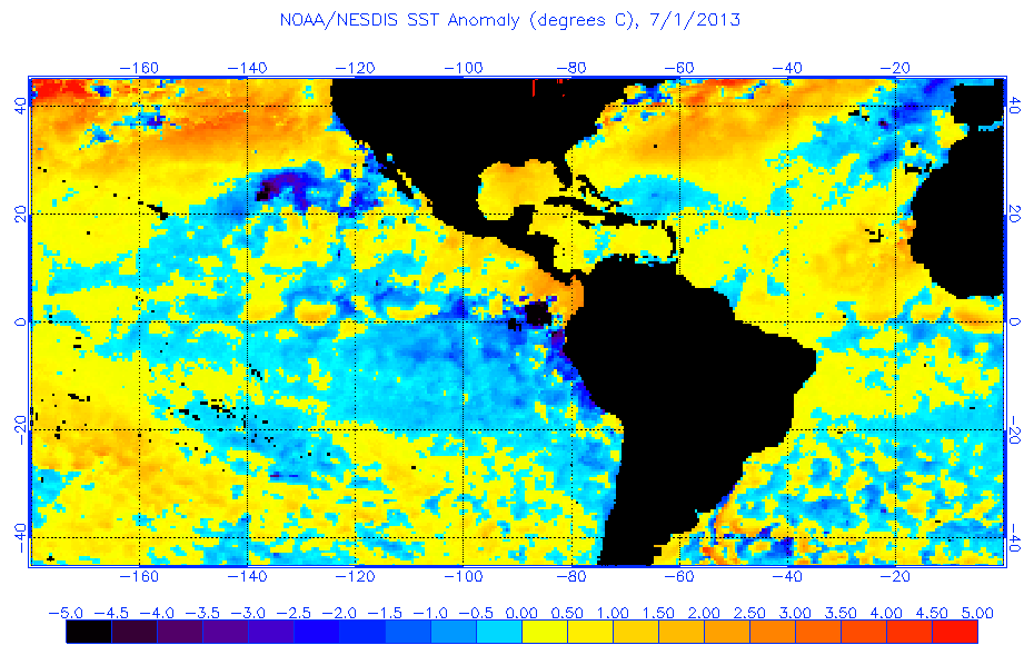
The warm subtropics issue in 2013 did not arise until the season had already begun; preseason forecasts pointed out a notably positive Atlantic tripole. Here is an image from July 2013 as the unfavorable anomalous subtropics pattern emerged:

Image
0 likes   

User avatar
NDG
S2K Supporter
S2K Supporter
Posts: 14947
Joined: Sun Jul 09, 2006 10:14 pm
Location: Orlando, FL

Re: 2017 indicators: SST's / MSLP / SAL / Steering / Instability

#356 Postby NDG » Wed May 17, 2017 7:31 am

Siker wrote:The warm subtropics issue in 2013 did not arise until the season had already begun; preseason forecasts pointed out a notably positive Atlantic tripole. Here is an image from July 2013 as the unfavorable anomalous subtropics pattern emerged:

http://www.ospo.noaa.gov/data/sst/anoma ... 1.2013.gif


Plus during the heart of the '13 season is when the whole Atlantic Basin from the MDR to the Caribbean to the GOM and even east coast went bone dry.
1 likes   

User avatar
TheStormExpert
Category 5
Category 5
Posts: 8487
Age: 30
Joined: Wed Feb 16, 2011 5:38 pm
Location: Palm Beach Gardens, FL

Re: 2017 indicators: SST's / MSLP / SAL / Steering / Instability

#357 Postby TheStormExpert » Wed May 17, 2017 8:46 am

NDG wrote:
Siker wrote:The warm subtropics issue in 2013 did not arise until the season had already begun; preseason forecasts pointed out a notably positive Atlantic tripole. Here is an image from July 2013 as the unfavorable anomalous subtropics pattern emerged:

http://www.ospo.noaa.gov/data/sst/anoma ... 1.2013.gif


Plus during the heart of the '13 season is when the whole Atlantic Basin from the MDR to the Caribbean to the GOM and even east coast went bone dry.

On top of that overall conditions(especially in the Tropical Atlantic) were looking more favorable in June when compared with September. Clearly there were MANY ASPECTS that went wrong that season that lead to the HUGE bust in the seasonal forecasts from the experts. CSU, and NOAA were basically predicting upwards of almost 20 NS's, with nearly 10 H's, and 3-5 MH's.
0 likes   
The following post is NOT an official forecast and should not be used as such. It is just the opinion of the poster and may or may not be backed by sound meteorological data. It is NOT endorsed by storm2k.org.

WeatherEmperor
S2K Supporter
S2K Supporter
Posts: 4806
Age: 40
Joined: Thu Sep 04, 2003 2:54 pm
Location: South Florida

Re: 2017 indicators: SST's / MSLP / SAL / Steering / Instability

#358 Postby WeatherEmperor » Wed May 17, 2017 9:36 am

Do any of you guys have the ECMWF sea level pressure forecast maps for 2013? I would like to see if it showed higher pressures for ASO and maybe we just didnt pay attention to it. Is that the case?


Sent from my iPhone 7 using Tapatalk
1 likes   

User avatar
cycloneye
Admin
Admin
Posts: 139596
Age: 67
Joined: Thu Oct 10, 2002 10:54 am
Location: San Juan, Puerto Rico

Re: 2017 indicators: SST's / MSLP / SAL / Steering / Instability

#359 Postby cycloneye » Wed May 17, 2017 10:52 am

WeatherEmperor wrote:Do any of you guys have the ECMWF sea level pressure forecast maps for 2013? I would like to see if it showed higher pressures for ASO and maybe we just didnt pay attention to it. Is that the case?


Sent from my iPhone 7 using Tapatalk


Here is the graphic of May 2013 for ASO.

Image
0 likes   
Visit the Caribbean-Central America Weather Thread where you can find at first post web cams,radars
and observations from Caribbean basin members Click Here

User avatar
weathaguyry
Category 5
Category 5
Posts: 1272
Age: 21
Joined: Wed Jun 15, 2016 5:16 am
Location: Long Island, NY

Re: 2017 indicators: SST's / MSLP / SAL / Steering / Instability

#360 Postby weathaguyry » Wed May 17, 2017 11:01 am

I think that 2013 could be a year to compare to, but it was more of an anomaly, because there were issues with getting out of a spring pattern, which had nothing to do with ENSO or SSTA's. I don't know of anytime other than 2013 and 2005 where there was a huge forecasting failure for the Hurricane Season. By what I'm seeing now, I think that pattern is progressing nicely towards summer, and I don't see anything that would stop the progress. Someone correct me if I am wrong please.
0 likes   
My posts are only my opinions and NOT official forecasts. For official forecasts, consult the National Hurricane Center or the National Weather Service.

Irene 11', Sandy 12', Fay 20’, Isaias 20’, Elsa 21’, Henri 21’, Ida 21’


Return to “Talkin' Tropics”

Who is online

Users browsing this forum: cajungal, Cpv17, Hurricane2022, kevin, TheAustinMan and 96 guests