Analysis,Models,Sat Pics of Low in Western Atlantic
Moderator: S2k Moderators
Forum rules

The posts in this forum are NOT official forecasts and should not be used as such. They are just the opinion of the poster and may or may not be backed by sound meteorological data. They are NOT endorsed by any professional institution or STORM2K. For official information, please refer to products from the National Hurricane Center and National Weather Service.
-
HurricaneHunter914
- Category 5

- Posts: 4439
- Age: 32
- Joined: Fri Mar 10, 2006 7:36 pm
- Location: College Station, TX
Well, at least Florida will get the much need rain from this system, even if it isn't going to become anything.
0 likes
Personal Forecast Disclaimer:
The posts in this forum are NOT official forecast and should not be used as such. They are just the opinion of the poster and may or may not be backed by sound meteorological data. They are NOT endorsed by any professional institution or storm2k.org. For official information, please refer to the NHC and NWS products.
The posts in this forum are NOT official forecast and should not be used as such. They are just the opinion of the poster and may or may not be backed by sound meteorological data. They are NOT endorsed by any professional institution or storm2k.org. For official information, please refer to the NHC and NWS products.
-
wxman57

- Moderator-Pro Met

- Posts: 23172
- Age: 68
- Joined: Sat Jun 21, 2003 8:06 pm
- Location: Houston, TX (southwest)
Opal storm wrote:No invest tomorrow unless something dramatic happens overnight.
Right. It's clearly weakening now. If the NHC was going to do something with it, the time would have been today not after the winds drop tonight and Tuesday. Just another winter-type low for the east coast. We'll have to wait until August for Andrea, I hope.
0 likes

-
curtadams
- S2K Supporter

- Posts: 1122
- Joined: Sun Aug 28, 2005 7:57 pm
- Location: Orange, California
- Contact:
What are the criteria for upgrading something like this to a subtropical storm? Earlier today I'd have said it was 100% extratropical with no indication at all of convection providing energy for this. Now the WV loops are showing a growing high-altitude moist zone, which indicates a little uplift is going on. But the vigorous CCW upper-level winds show it's still an upper low and extratropical forces are very much still running the show. At what point would one say it's subtropical? When outflow becomes visible? When upper winds turn CW? When a CDO appears?
0 likes
-
cycloneye

- Admin

- Posts: 149276
- Age: 69
- Joined: Thu Oct 10, 2002 10:54 am
- Location: San Juan, Puerto Rico
This has been only a preexcercise for us prior to the start of the 2007 season.It has activated the Talking Tropics forum in early May bigtime.At least it has been something that we are talking about as by early May,things are generally slow in the Atlantic Basin tropics and the forum is almost dead.
0 likes
Visit the Caribbean-Central America Weather Thread where you can find at first post web cams,radars
and observations from Caribbean basin members Click Here
and observations from Caribbean basin members Click Here
-
JonathanBelles
- Professional-Met

- Posts: 11430
- Age: 35
- Joined: Sat Dec 24, 2005 9:00 pm
- Location: School: Florida State University (Tallahassee, FL) Home: St. Petersburg, Florida
- Contact:
cycloneye wrote:This has been only a preexcercise for us prior to the start of the 2007 season.It has activated the Talking Tropics forum in early May bigtime.At least it has been something that we are talking about as by early May,things are generally slow in the Atlantic Basin tropics and the forum is almost dead.
I'm enjoying the increase in activity for the forums compared to the dead of the season.
0 likes
-
kevin
-
SouthFloridawx

- S2K Supporter
- Posts: 8346
- Age: 47
- Joined: Tue Jul 26, 2005 1:16 am
- Location: Sarasota, FL
- Contact:

wxman57 wrote:'CaneFreak wrote:
Dr. Steve Lyons was just on the TWC and his SST graphic conflicted with the SST graphic you posted. Maybe it is a resolution thing? I don't know, but I thought you should know. The map I posted is accurate afterall....For those of you on the subtropical bandwagon, it is not going to have time. But, that does not mean it will not bring you some rain. It can still bring you some rain without ever becoming subtropical
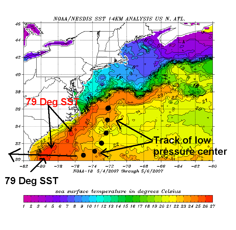
Here's another higher-resolution SST graphic. Temps across the Gulf stream are in the 79-80 degree range over a narrow band, with much cooler water all around. With so much cool dry air around the low, chances of warm-core transition are very low.

Thanks wxman57
Canefreak, here's another better SST graphic than the one you posted last night, pointing out out that spots in the GS are at least 79 deg, where the low center will track over tomorrow night and Wed morning. Later on tonight it should start tracking over SST in the mid to upper 70s, plenty warm in my opinion, but like I said yeterday, the dry air around this system seems to be the killer right now.
0 likes
-
Stormavoider
- Category 2

- Posts: 671
- Joined: Sat Jul 01, 2006 4:37 pm
- Location: Spring Hill Fl.
I may be misreading this loop, but it seems like the moisture is increasing around this thing.
0 likes
-
Extremeweatherguy

- Category 5
- Posts: 11095
- Joined: Mon Oct 10, 2005 8:13 pm
- Location: Florida
I hope we wait until August too, but based on recent seasons I am not so sure that will be the case. Seems like there always wants to be at least one early tropical storm now days. However, this year could be different. We'll see. Let's just hope we don't have another 2004 where we go from quiet to explosive and damaging right as August hits.wxman57 wrote:Opal storm wrote:No invest tomorrow unless something dramatic happens overnight.
Right. It's clearly weakening now. If the NHC was going to do something with it, the time would have been today not after the winds drop tonight and Tuesday. Just another winter-type low for the east coast. We'll have to wait until August for Andrea, I hope.
0 likes
-
wxman57
- Moderator-Pro Met
- Posts: 23172
- Age: 68
- Joined: Sat Jun 21, 2003 8:06 pm
- Location: Houston, TX (southwest)
Extremeweatherguy wrote:I hope we wait until August too, but based on recent seasons I am not so sure that will be the case. Seems like there always wants to be at least one early tropical storm now days. However, this year could be different. We'll see. Let's just hope we don't have another 2004 where we go from quiet to explosive and damaging right as August hits.wxman57 wrote:Opal storm wrote:No invest tomorrow unless something dramatic happens overnight.
Right. It's clearly weakening now. If the NHC was going to do something with it, the time would have been today not after the winds drop tonight and Tuesday. Just another winter-type low for the east coast. We'll have to wait until August for Andrea, I hope.
It's interesting to note that I promised my boss no named storms until August 1st in 2004, too. The first TD formed the evening of July 31st and we had Alex August 1st. Let's see if I can do it again!
0 likes
-
SouthFloridawx
- S2K Supporter
- Posts: 8346
- Age: 47
- Joined: Tue Jul 26, 2005 1:16 am
- Location: Sarasota, FL
- Contact:
Here is a pretty cool article I found on Subtropical systems...
https://courseware.e-education.psu.edu/ ... lones.html
https://courseware.e-education.psu.edu/ ... lones.html
0 likes
-
GeneratorPower

- S2K Supporter
- Posts: 1648
- Age: 46
- Joined: Sun Dec 18, 2005 11:48 pm
- Location: Huntsville, AL
-
MiamiensisWx
Extremeweatherguy wrote:I hope we wait until August too, but based on recent seasons I am not so sure that will be the case. Seems like there always wants to be at least one early tropical storm now days. However, this year could be different. We'll see. Let's just hope we don't have another 2004 where we go from quiet to explosive and damaging right as August hits.
Actually many historical seasons have featured June and July (or pre-seasonal) development. During many previous years, early-season tropical development frequently originates in the month of June. See Allison (1995) and other examples. The western Caribbean Sea is a frequent site for homegrown development.
0 likes
nice evening in palm beach went down to spot in N. palm beach (was curious about the high tide)
minimal overwash as winds are offshore but breakers are 10-12 feet and it sounds like thunder when they are breaking from a distance. awesome
outer canaveral bouy was reporting swell heights (not wave) of over 20 feet at 16 seconds for 3 straight hours ( you do not see that every year)
winds gusting to about 20 and temps a chilled 63.
0 likes

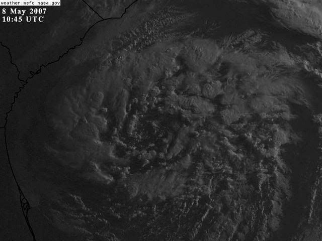
This was a special feature in the 2:05am TWD. It's an "occluded" low now:
The surface low has weakened since yesterday, but convection has increased closer to the center. Looks more subtropical than it did yesterday.
...SPECIAL FEATURE...
AN OCCLUDED 1001 MB SFC LOW WAS LOCATED NEAR 30.5N 75.0W AS OF
08/0300 UTC...OR ABOUT 300NM E OF THE FLORIDA/GEORGIA BORDER. A
STORM WARNING ASSOCIATED WITH THIS SYSTEM IS IN AFFECT FOR THE
OFFSHORE AREA N OF 28N W OF 74W BUT IS EXPECTED TO RELAX TO GALE
CONDITIONS THROUGH MORNING. THIS WAS VERIFIED BY THE 0000 UTC
QUIKSCAT PASS WHICH SHOWED 50-60 KT WINDS OFF THE SOUTHEAST
COAST. THESE WINDS ARE CONTINUING TO PRODUCE A SIGNIFICANT SWELL
EVENT FOR THE SOUTHEAST U.S. COAST AND THE BAHAMAS. BUOY 41010
RECENTLY REPORTED 25 FT SEAS AT 16 SEC...WITH BOTH THE PERIOD
AND HEIGHT SLIGHTLY UNDERDONE BY THE REGIONAL WW3. LIGHTNING
DATA HAS BEEN DEPICTING SCATTERED TSTMS ESPECIALLY N AND E OF
THE CENTER OVER THE LAST FEW HOURS FROM 29N-33N BETWEEN 75W-79W.
THE MAIN THREAT...HOWEVER...WILL CONTINUE TO BE THE HIGH WINDS
AND WAVES ASSOCIATED WITH THE SYSTEM. THE MODEL CONSENSUS IS TO
MOVE THE LOW WEST TOWARDS NORTH FLORIDA/GEORGIA OVER THE NEXT 36
HOURS WHILE SLOWLY WEAKENING. PLEASE REFER TO THE HIGH SEAS
FORECASTS AND STATEMENTS FROM LOCAL WEATHER FORECAST OFFICES FOR
MORE DETAILS REGARDING EXPECTED OFFSHORE AND COASTAL IMPACTS.
The surface low has weakened since yesterday, but convection has increased closer to the center. Looks more subtropical than it did yesterday.
0 likes


-
wxman57
- Moderator-Pro Met
- Posts: 23172
- Age: 68
- Joined: Sat Jun 21, 2003 8:06 pm
- Location: Houston, TX (southwest)
GeneratorPower wrote:wxman57 wrote:It's interesting to note that I promised my boss no named storms until August 1st in 2004, too. The first TD formed the evening of July 31st and we had Alex August 1st. Let's see if I can do it again!
He won't tell you he ALSO promised him this in 2005.
Actually, I told my boss I definitely could NOT promise him the same in 2005.
0 likes
Who is online
Users browsing this forum: No registered users and 220 guests