Invest 98L in Western Atlantic

This is the general tropical discussion area. Anyone can take their shot at predicting a storms path.

Moderator: S2k Moderators

Forum rules

The posts in this forum are NOT official forecasts and should not be used as such. They are just the opinion of the poster and may or may not be backed by sound meteorological data. They are NOT endorsed by any professional institution or STORM2K. For official information, please refer to products from the National Hurricane Center and National Weather Service.

Help Support Storm2K
Message
Author
User avatar
HURAKAN
Professional-Met
Professional-Met
Posts: 46086
Age: 38
Joined: Thu May 20, 2004 4:34 pm
Location: Key West, FL
Contact:

#341 Postby HURAKAN » Mon Jul 30, 2007 7:32 am

Image

Looking better than yesterday, much better I'll say.
0 likes   

User avatar
Thunder44
Category 5
Category 5
Posts: 5922
Age: 44
Joined: Mon Jun 09, 2003 7:53 pm
Location: New York City

Re: Invest 98L in Western Atlantic

#342 Postby Thunder44 » Mon Jul 30, 2007 7:45 am

With convection well away from the center at this point, it may be taken on sub-tropical characteristics. Will be interesting to see if TPC will actually classify this.
0 likes   

User avatar
senorpepr
Military Met/Moderator
Posts: 12542
Age: 43
Joined: Fri Aug 22, 2003 9:22 pm
Location: Mackenbach, Germany
Contact:

Re: Invest 98L in Western Atlantic

#343 Postby senorpepr » Mon Jul 30, 2007 7:49 am

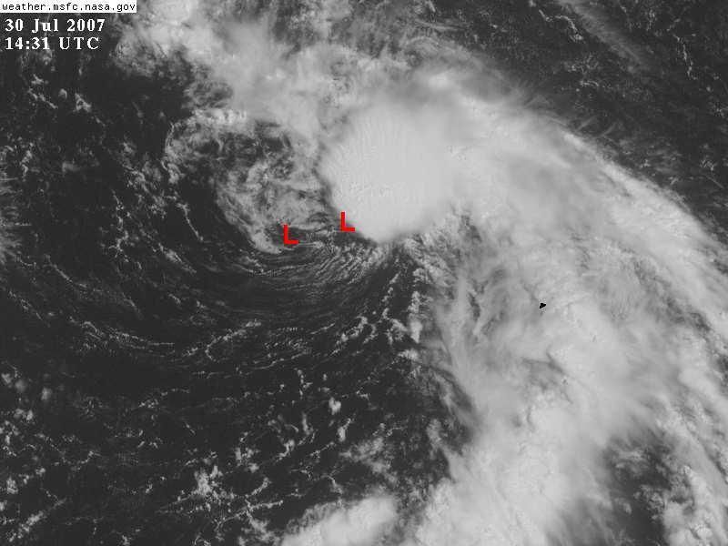
Thunder44 wrote:With convection well away from the center at this point, it may be taken on sub-tropical characteristics. Will be interesting to see if TPC will actually classify this.


FWIW, a few mets at work have a forecast contest where they are guess when this, along with a few other random blobs, will get names from the NHC. It's been a pretty strong consensus that the NHC has been rather "liberal" (and I'm not talking politics) in their name game lately.
0 likes   

User avatar
Aquawind
Category 5
Category 5
Posts: 6714
Age: 62
Joined: Mon Jun 16, 2003 10:41 pm
Location: Salisbury, NC
Contact:

#344 Postby Aquawind » Mon Jul 30, 2007 7:51 am

One of many naked swirls durring the year.. Microscopic potential for any impacts other that rain in Bermuda even if the classified. 8-)
0 likes   

User avatar
HURAKAN
Professional-Met
Professional-Met
Posts: 46086
Age: 38
Joined: Thu May 20, 2004 4:34 pm
Location: Key West, FL
Contact:

#345 Postby HURAKAN » Mon Jul 30, 2007 7:54 am

If Arlene and Alberto were classified, then this most get classified. The main difference is latitude and its implications.
0 likes   

User avatar
senorpepr
Military Met/Moderator
Posts: 12542
Age: 43
Joined: Fri Aug 22, 2003 9:22 pm
Location: Mackenbach, Germany
Contact:

Re:

#346 Postby senorpepr » Mon Jul 30, 2007 7:56 am

HURAKAN wrote:If Arlene and Alberto were classified, then this most get classified. The main difference is latitude and its implications.


But will it and should it are two different questions. (Adjust the tense to apply to Arlene and Alberto, as necessary.)
0 likes   

User avatar
HURAKAN
Professional-Met
Professional-Met
Posts: 46086
Age: 38
Joined: Thu May 20, 2004 4:34 pm
Location: Key West, FL
Contact:

#347 Postby HURAKAN » Mon Jul 30, 2007 7:57 am

30/1145 UTC 32.7N 68.5W TOO WEAK 98L -- Atlantic Ocean
0 likes   

User avatar
drezee
S2K Supporter
S2K Supporter
Posts: 3664
Joined: Mon Jun 09, 2003 12:49 pm
Location: FL

Re: Invest 98L in Western Atlantic

#348 Postby drezee » Mon Jul 30, 2007 9:01 am

This system should be classified within 12 hours. Convection is exploding over the center
0 likes   

Frank2
Category 5
Category 5
Posts: 4061
Joined: Mon Jul 25, 2005 12:47 pm

#349 Postby Frank2 » Mon Jul 30, 2007 9:17 am

No center is evident - the cluster of thunderstorms are west of any broad circulation at this time...

Relax, folks...

Personally, I'm not in any rush to pay $5 for a gallon of gasoline...
0 likes   

User avatar
gatorcane
S2K Supporter
S2K Supporter
Posts: 23692
Age: 47
Joined: Sun Mar 13, 2005 3:54 pm
Location: Boca Raton, FL

#350 Postby gatorcane » Mon Jul 30, 2007 9:19 am

Frank I think you meant to post in the other thread....I won't be getting any gasoline for this invest!!! :wink:
0 likes   

User avatar
hurricanefloyd5
Category 5
Category 5
Posts: 1659
Age: 44
Joined: Sun May 02, 2004 10:53 am
Location: Spartanburg
Contact:

Re: Invest 98L in Western Atlantic

#351 Postby hurricanefloyd5 » Mon Jul 30, 2007 9:25 am

Whoo Hoo 98L looks preety good to me when it comes to being a SubTropicalStorm for the most part LOL!!!!!!!!
0 likes   

User avatar
MusicCityMan
Category 1
Category 1
Posts: 483
Joined: Sat Feb 17, 2007 10:57 pm
Location: Somewhere in Central Florida

Re: Invest 98L in Western Atlantic

#352 Postby MusicCityMan » Mon Jul 30, 2007 9:28 am

Come on wanna be Chantal.. Cross another name off the list.. It'd be nice to see our 3rd storm even if it's just a harmless fish..
0 likes   

User avatar
NDG
S2K Supporter
S2K Supporter
Posts: 15455
Joined: Sun Jul 09, 2006 10:14 pm
Location: Orlando, FL

#353 Postby NDG » Mon Jul 30, 2007 9:46 am

I think we STS Chantal in the making this morning, two distinct LLCs were visible this morning, rotating around the broaders circulation, the one most noticed this morning is very close to the convection now:

Image
0 likes   

User avatar
HURAKAN
Professional-Met
Professional-Met
Posts: 46086
Age: 38
Joined: Thu May 20, 2004 4:34 pm
Location: Key West, FL
Contact:

#354 Postby HURAKAN » Mon Jul 30, 2007 9:54 am

0 likes   

CrazyC83
Professional-Met
Professional-Met
Posts: 34006
Joined: Tue Mar 07, 2006 11:57 pm
Location: Deep South, for the first time!

#355 Postby CrazyC83 » Mon Jul 30, 2007 9:57 am

I would classify it as STD3 right now, since I believe winds are 30 knots but there seems to be a closed circulation.
0 likes   

User avatar
HURAKAN
Professional-Met
Professional-Met
Posts: 46086
Age: 38
Joined: Thu May 20, 2004 4:34 pm
Location: Key West, FL
Contact:

#356 Postby HURAKAN » Mon Jul 30, 2007 10:00 am

Image

98L.INVEST.30kts.1011mb
0 likes   

User avatar
hurricanefloyd5
Category 5
Category 5
Posts: 1659
Age: 44
Joined: Sun May 02, 2004 10:53 am
Location: Spartanburg
Contact:

Re: Invest 98L in Western Atlantic

#357 Postby hurricanefloyd5 » Mon Jul 30, 2007 10:04 am

come on Chantal WE ALMOST FOUND YOU!!!!!!!! :lol:

PS sorry about the caps!!!!!!
0 likes   

User avatar
HURAKAN
Professional-Met
Professional-Met
Posts: 46086
Age: 38
Joined: Thu May 20, 2004 4:34 pm
Location: Key West, FL
Contact:

#358 Postby HURAKAN » Mon Jul 30, 2007 10:04 am

For the North Atlantic...Caribbean Sea and the Gulf of Mexico...

Shower and thunderstorm activity associated with a low pressure area
centered about 175 miles west-northwest of Bermuda has become
better organized this morning. Environmental conditions are only
marginally favorable for significant development. However...the
system could become a tropical or subtropical cyclone before
merging with a frontal boundary in a couple of days as it moves
northeastward around 15 mph.

An area of cloudiness and showers located about 950 miles east of
the southern Windward Islands is associated with a westward-moving
tropical wave. This area shows signs of organization...and some
slow development of this system is possible during the next couple
of days.

Elsewhere...tropical cyclone formation is not expected during the
next 48 hours.
$$

Forecaster Brown/Pasch
0 likes   

User avatar
NDG
S2K Supporter
S2K Supporter
Posts: 15455
Joined: Sun Jul 09, 2006 10:14 pm
Location: Orlando, FL

Re: Invest 98L in Western Atlantic

#359 Postby NDG » Mon Jul 30, 2007 10:05 am

Not bad for just a test, :lol:
0 likes   

User avatar
HURAKAN
Professional-Met
Professional-Met
Posts: 46086
Age: 38
Joined: Thu May 20, 2004 4:34 pm
Location: Key West, FL
Contact:

#360 Postby HURAKAN » Mon Jul 30, 2007 10:06 am

The next 6 hours are going to determine if at 5 PM we have Chantal or at least STD/TD 3.
0 likes   


Return to “Talkin' Tropics”

Who is online

Users browsing this forum: redingtonbeach and 46 guests