2022 Indicators (SSTs/SAL/MSLP/Shear/Steering/Instability) and >Day 16 Models
Moderator: S2k Moderators
Forum rules

The posts in this forum are NOT official forecasts and should not be used as such. They are just the opinion of the poster and may or may not be backed by sound meteorological data. They are NOT endorsed by any professional institution or STORM2K. For official information, please refer to products from the National Hurricane Center and National Weather Service.
-
Category5Kaiju

- Category 5

- Posts: 4330
- Joined: Thu Dec 24, 2020 12:45 pm
- Location: Seattle and Phoenix
Re: 2022 Indicators (SSTs/SAL/MSLP/Shear/Steering/Instability) and >Day 16 Models
After this season, I would genuinely be surprised to see serious 2013 2.0 comparisons in subsequent years. Now that we have a major hurricane, 2013 is now a pretty remote analog for 2022. After nearly a decade, 2013 2.0 predictions have all but materialized, and if a season that looked dead at first like 2022 has the ability to spring to life and produce hurricanes (with even a major lol), then it's gotta become to the point that people realize how much of a black swan event 2013 was...right? 
6 likes
Unless explicitly stated, all info in my posts is based on my own opinions and observations. Tropical storms and hurricanes can be extremely dangerous. Refer to an accredited weather research agency or meteorologist if you need to make serious decisions regarding an approaching storm.
-
tolakram
- Admin

- Posts: 20178
- Age: 62
- Joined: Sun Aug 27, 2006 8:23 pm
- Location: Florence, KY (name is Mark)
Re: 2022 Indicators (SSTs/SAL/MSLP/Shear/Steering/Instability) and >Day 16 Models
We've strayed pretty far from indicators.
We know this is broken, but I think it's the normal line, so just picture this being closer to normal.

We know this is broken, but I think it's the normal line, so just picture this being closer to normal.
1 likes
M a r k
- - - - -
Join us in chat: Storm2K Chatroom Invite. Android and IOS apps also available.
The posts in this forum are NOT official forecasts and should not be used as such. Posts are NOT endorsed by any professional institution or STORM2K.org. For official information and forecasts, please refer to NHC and NWS products.

Re: 2022 Indicators (SSTs/SAL/MSLP/Shear/Steering/Instability) and >Day 16 Models
A lot can change in just a week. This was what the GFS from one week ago believed today would look like. The shear looked too high, the environment too dry, the season was dead. We all know how that's turning out.

6 likes
-
tolakram
- Admin
- Posts: 20178
- Age: 62
- Joined: Sun Aug 27, 2006 8:23 pm
- Location: Florence, KY (name is Mark)
Re: 2022 Indicators (SSTs/SAL/MSLP/Shear/Steering/Instability) and >Day 16 Models
I moved a bunch of posts over to the slow start thread. PLEASE KEEP THIS AS INDICATORS ONLY. Off topic posts will be deleted. Thanks!
1 likes
M a r k
- - - - -
Join us in chat: Storm2K Chatroom Invite. Android and IOS apps also available.
The posts in this forum are NOT official forecasts and should not be used as such. Posts are NOT endorsed by any professional institution or STORM2K.org. For official information and forecasts, please refer to NHC and NWS products.
- - - - -
Join us in chat: Storm2K Chatroom Invite. Android and IOS apps also available.
The posts in this forum are NOT official forecasts and should not be used as such. Posts are NOT endorsed by any professional institution or STORM2K.org. For official information and forecasts, please refer to NHC and NWS products.
-
Category5Kaiju
- Category 5
- Posts: 4330
- Joined: Thu Dec 24, 2020 12:45 pm
- Location: Seattle and Phoenix
Re: 2022 Indicators (SSTs/SAL/MSLP/Shear/Steering/Instability) and >Day 16 Models
Looks like we now have a true +AMO horseshoe look in the Atlantic based on the sst anomaly maps
3 likes
Unless explicitly stated, all info in my posts is based on my own opinions and observations. Tropical storms and hurricanes can be extremely dangerous. Refer to an accredited weather research agency or meteorologist if you need to make serious decisions regarding an approaching storm.
-
Keldeo1997
- Category 2

- Posts: 688
- Joined: Fri Oct 11, 2019 11:35 pm
-
galaxy401

- Category 5
- Posts: 2446
- Age: 30
- Joined: Sat Aug 25, 2012 9:04 pm
- Location: Casa Grande, Arizona
Re: 2022 Indicators (SSTs/SAL/MSLP/Shear/Steering/Instability) and >Day 16 Models
Updating again to state that there is now: A Category 4 hurricane, a tropical storm, and three areas of interest by the NHC that are currently active. Prime season look for sure.
13 likes
Got my eyes on moving right into Hurricane Alley: Florida.
-
Iceresistance

- Category 5
- Posts: 9577
- Age: 22
- Joined: Sat Oct 10, 2020 9:45 am
- Location: Tecumseh, OK/Norman, OK
Re: 2022 Indicators (SSTs/SAL/MSLP/Shear/Steering/Instability) and >Day 16 Models
I can't find a good spot to post it, but this is the perfect quinfecta.

https://s5.gifyu.com/images/The-perfect-quinfecta.png
https://s5.gifyu.com/images/The-perfect-quinfecta.png
9 likes
Bill 2015 & Beta 2020
Winter 2020-2021
All observations are in Tecumseh, OK unless otherwise noted.
Winter posts are focused mainly for Oklahoma & Texas.
Take any of my forecasts with a grain of salt, refer to the NWS, SPC, and NHC for official information
Never say Never with weather! Because ANYTHING is possible!
Winter 2020-2021
All observations are in Tecumseh, OK unless otherwise noted.
Winter posts are focused mainly for Oklahoma & Texas.
Take any of my forecasts with a grain of salt, refer to the NWS, SPC, and NHC for official information
Never say Never with weather! Because ANYTHING is possible!
-
Category5Kaiju
- Category 5
- Posts: 4330
- Joined: Thu Dec 24, 2020 12:45 pm
- Location: Seattle and Phoenix
Re: 2022 Indicators (SSTs/SAL/MSLP/Shear/Steering/Instability) and >Day 16 Models
Iceresistance wrote:I can't find a good spot to post it, but this is the perfect quinfecta.
https://s5.gifyu.com/images/The-perfect-quinfecta.png
https://s5.gifyu.com/images/The-perfect-quinfecta.png
Assuming those AOIs eventually get named and October and November don’t see some weird basin wide shutdown like they did last year, then I really cannot see how we can’t end this season with at least 14-16 NSs. Maybe failed invests are a thing of the past now with this season
0 likes
Unless explicitly stated, all info in my posts is based on my own opinions and observations. Tropical storms and hurricanes can be extremely dangerous. Refer to an accredited weather research agency or meteorologist if you need to make serious decisions regarding an approaching storm.
-
Emmett_Brown

- Category 5
- Posts: 1433
- Joined: Wed Aug 24, 2005 9:10 pm
- Location: Sarasota FL
Re: 2022 Indicators (SSTs/SAL/MSLP/Shear/Steering/Instability) and >Day 16 Models
I'd say we have a chance (slim chance) but a chance, of having 5 simultaneous active TCs in the coming days.
3 likes

Re: 2022 Indicators (SSTs/SAL/MSLP/Shear/Steering/Instability) and >Day 16 Models
as expected a hyper active end to september my 11 storm prediction this month not looking crazy
1 likes
-
skyline385

- Category 5
- Posts: 2728
- Age: 35
- Joined: Wed Aug 26, 2020 11:15 pm
- Location: Houston TX


Re: 2022 Indicators (SSTs/SAL/MSLP/Shear/Steering/Instability) and >Day 16 Models
Category5Kaiju wrote:Iceresistance wrote:I can't find a good spot to post it, but this is the perfect quinfecta.
https://s5.gifyu.com/images/The-perfect-quinfecta.png
https://s5.gifyu.com/images/The-perfect-quinfecta.png
Assuming those AOIs eventually get named and October and November don’t see some weird basin wide shutdown like they did last year, then I really cannot see how we can’t end this season with at least 14-16 NSs. Maybe failed invests are a thing of the past now with this season
I’ve been curious as to October and November. September went like it was indicating both at the peak and month end. But I seriously don’t have a feel for October at all. We have been talking about mostly slow progression of often diffuse waves since early summer. Plus the warm higher latitudes and other inhibitors. So outside of homegrown systems or coastal lows, there first has to be tropical waves. If so, more out to sea? Florida/Bahamas threats? I saw somebody posted Joe B the other day kind of saying 98L was endgame. I suppose to be fair that he could have meant the backing pattern of how this series of storms each came up further west since he was talking about that also. I think he’ll end up being wrong about Fiona which I still think is going to get caught and brought in so grain of salt.
But it seems hard to bet against no fall systems in a La Niña even if it’s 3rd year. OTOH Hammy seemed to indicate CFS being quiet. I only follow it through her interpretation but sometimes it gets the trends. It’s easier for me to predict when there’s a stronger MJO signal year unlike 2022.
2 likes
-
TallyTracker
- Category 2
- Posts: 787
- Joined: Thu Oct 11, 2018 2:46 pm
Re: 2022 Indicators (SSTs/SAL/MSLP/Shear/Steering/Instability) and >Day 16 Models
skyline385 wrote:Wow
https://twitter.com/quintonlawton/status/1572958300324655113?s=46&t=eQooB92WVFdh4VCnvnSobw
Sent from my iPhone using Tapatalk
Flying over the SAL just got on my bucket list!
0 likes
Fran '96, Georges '98, Gordon '00, Gabrielle '01, Charley '04, Frances '04, Jeanne '04, Barry '07, Fay '08, Debby '12, Matthew '16, Emily '17, Irma '17, Michael ‘18, Elsa ‘21, Fred ‘21, Mindy ‘21, Nicole ‘22, Idalia ‘23, Debby ‘24, Helene ‘24
-
Iceresistance
- Category 5
- Posts: 9577
- Age: 22
- Joined: Sat Oct 10, 2020 9:45 am
- Location: Tecumseh, OK/Norman, OK
Re: 2022 Indicators (SSTs/SAL/MSLP/Shear/Steering/Instability) and >Day 16 Models
So much for a 'Slow Season', now we have 4 Tropical Cyclones active at once!
3 likes
Bill 2015 & Beta 2020
Winter 2020-2021
All observations are in Tecumseh, OK unless otherwise noted.
Winter posts are focused mainly for Oklahoma & Texas.
Take any of my forecasts with a grain of salt, refer to the NWS, SPC, and NHC for official information
Never say Never with weather! Because ANYTHING is possible!
Winter 2020-2021
All observations are in Tecumseh, OK unless otherwise noted.
Winter posts are focused mainly for Oklahoma & Texas.
Take any of my forecasts with a grain of salt, refer to the NWS, SPC, and NHC for official information
Never say Never with weather! Because ANYTHING is possible!
-
cycloneye

- Admin
- Posts: 149261
- Age: 69
- Joined: Thu Oct 10, 2002 10:54 am
- Location: San Juan, Puerto Rico
Re: 2022 Indicators (SSTs/SAL/MSLP/Shear/Steering/Instability) and >Day 16 Models
5 likes
Visit the Caribbean-Central America Weather Thread where you can find at first post web cams,radars
and observations from Caribbean basin members Click Here
and observations from Caribbean basin members Click Here
-
weeniepatrol

- Category 5
- Posts: 1340
- Joined: Sat Aug 22, 2020 5:30 pm
- Location: WA State
Re: 2022 Indicators (SSTs/SAL/MSLP/Shear/Steering/Instability) and >Day 16 Models
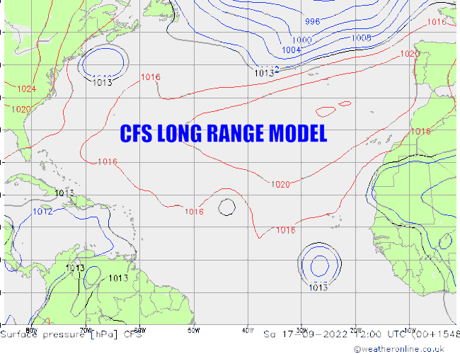
SFLcane wrote:cycloneye wrote:SFLcane wrote:My treat for S2K for today! Enjoy your weekend guys
https://i.postimg.cc/Hs0xGH6g/CFS.gif
A slower loop to see it better.
Your wish is my command!
https://i.postimg.cc/mktQXkYB/CFS2-JPEG.gif
As illustrated above, in mid-July, the CFS had one system affecting the Canadian Maritimes followed by another system heading towards Florida from the southeast during this general time period in late September. Not bad…not bad at all.
8 likes
-
weeniepatrol
- Category 5
- Posts: 1340
- Joined: Sat Aug 22, 2020 5:30 pm
- Location: WA State
Re: 2022 Indicators (SSTs/SAL/MSLP/Shear/Steering/Instability) and >Day 16 Models
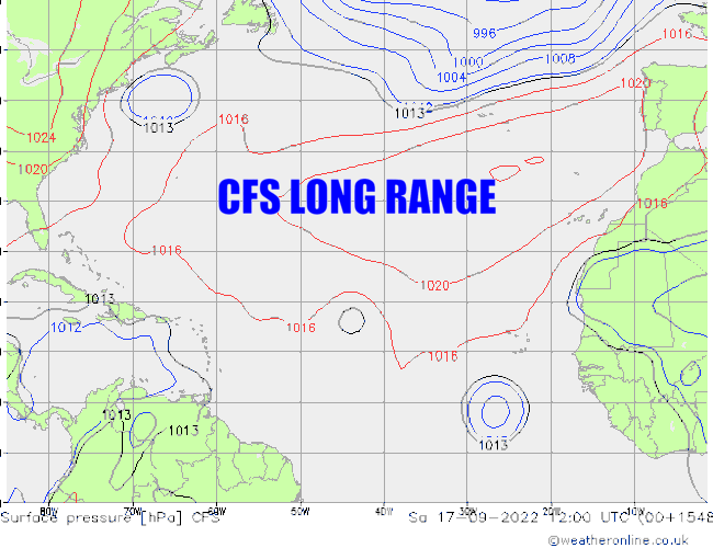
869MB wrote:SFLcane wrote:cycloneye wrote:
A slower loop to see it better.
Your wish is my command!
https://i.postimg.cc/mktQXkYB/CFS2-JPEG.gif
As illustrated above, in mid-July, the CFS had one system affecting the Canadian Maritimes followed by another system heading towards Florida from the southeast during this general time period in late September. Not bad…not bad at all.
Yeah, I know s2k user Hammy has mentioned that it generally depicted a sharply backloaded with an onset delayed by a couple weeks relative to the climatological peak... very interesting indeed
1 likes
-
tolakram
- Admin
- Posts: 20178
- Age: 62
- Joined: Sun Aug 27, 2006 8:23 pm
- Location: Florence, KY (name is Mark)
Re: 2022 Indicators (SSTs/SAL/MSLP/Shear/Steering/Instability) and >Day 16 Models
Second year in a row it's done well AND actually showed storms, not exact timing or track, but surprisingly informative IMO.
3 likes
M a r k
- - - - -
Join us in chat: Storm2K Chatroom Invite. Android and IOS apps also available.
The posts in this forum are NOT official forecasts and should not be used as such. Posts are NOT endorsed by any professional institution or STORM2K.org. For official information and forecasts, please refer to NHC and NWS products.
- - - - -
Join us in chat: Storm2K Chatroom Invite. Android and IOS apps also available.
The posts in this forum are NOT official forecasts and should not be used as such. Posts are NOT endorsed by any professional institution or STORM2K.org. For official information and forecasts, please refer to NHC and NWS products.
Who is online
Users browsing this forum: No registered users and 73 guests