


Seasonal Indicators (Beyond Day 16): Instability / SST's / MSLP / Steering / Sal
Moderator: S2k Moderators
Forum rules

The posts in this forum are NOT official forecasts and should not be used as such. They are just the opinion of the poster and may or may not be backed by sound meteorological data. They are NOT endorsed by any professional institution or STORM2K. For official information, please refer to products from the National Hurricane Center and National Weather Service.
Re: 2016 indicators: Instability / SST's / MSLP / Steering / Sal
Someone correct me if I'm wrong, but my understanding is that positive anomalies on this map represent anomalous westerly wind velocity. If that's the case, then the CFS has been forecasting weaker trades across the Caribbean for August:
0 likes
-
Andrew92

- S2K Supporter

- Posts: 3247
- Age: 42
- Joined: Mon Jun 16, 2003 12:35 am
- Location: Phoenix, Arizona
Re: 2016 indicators: Instability / SST's / MSLP / Steering / Sal
The following post is NOT an official forecast and should not be used as such. It is just the opinion of the poster and may or may not be backed by sound meteorological data. It is NOT endorsed by any professional institution or storm2k.org. For official information, please refer to the NHC and NWS products.
I made a new discovery last night that I actually probably should have known previously, but somehow had overlooked. It's a new potential analog year thinking outside the box of many others, considering what kind of EPAC SST profile appears to be setting up. That profile, I think, will be some sort of La Nina at the Equator, coupled with a warm EPAC MDR.
This kind of profile occurred in quite textbook fashion in 1959 and 1992, both of which I have as solid analogs for this year. The EPAC was quite busy both years, going as far as to produce a Hawaiian hurricane in each, along with a strong October hurricane along Mexico's west coast (1992 actually had two). The tropical Atlantic, think south of 20 degrees, was very quiet and overall unfavorable. But the subtropical latitudes were hot beds for storms to develop and intensify. This made for a rather average season overall in 1959, and potentially average in 1992 pending re-analysis of several storms currently undocumented in HURDAT.
But I discovered one year that had a similar, but weaker warm SST profile in the EPAC to those two years, and it was not 1983 as has been well-suggested. I was quite surprised, and have had to think all day about this one, but this possible analog year did actually have some similarities to 1959 and 1992. That year was 1985, a year well known as a busy season for US landfall activity. Naturally, when I saw that, I questioned how that year could be similar to those other two years, which seemed quieter?
But a closer look does bode similarities. 1985 did have a busy EPAC season, despite all the US hurricanes that year. Hurricane Nele even followed a path not too far off from Iniki, but was just much farther west and less of a threat. Hurricane Waldo was weaker than the 1959 hurricane or Hurricanes Virgil and Winifred in 1992, but otherwise was an October hurricane into Mexico. And unbelievably, for a year seen as that active for the Atlantic, there was only one hurricane all year in that basin south of 20 degrees: Gloria, also the only long-tracking storm that year. And only a forming Isabel was even a tropical storm in those latitudes in addition to that. The storms that did develop and for the most part hit the US did not become storms until they were closer to subtropical latitudes. It just so happened that the "sweet spot" for development was areas near the Bahamas and in the Gulf of Mexico, close to home. And that is also wildly similar to 1959 if you think about it. Fewer storms hit the US as hurricanes in 1959 (and one of them, Cindy, may be on the way down to a tropical storm), probably because a warmer EPAC MDR curtailed favorable conditions more that year than in 1985. But six individual storms, two or three of them hurricanes, did strike the US that year, similar to the eight that hit in 1985 (five or six hurricanes depending on what you think of Bob that year. I think he could get downgraded but we'll see).
However, other than the original basic similarities, it's hard to really find other comparable entities for 1985 and 1992. The latter had more storms over the open Atlantic instead that weren't as threatening. That said, there may be additional storms currently not in HURDAT that could change things for that year. 1959 and 1985 had rather average ACE's overall, and if new storms are added to 1992, that year could see an uptick to average as well.
All in all, I wouldn't invest too much in comparing this year to 1985 though. I think La Nina is coming at the Equator, but the warm anomalies in the EPAC MDR appear much stronger than that year, which I think would probably disallow that many hurricanes in the US. It can't hurt to be ready though, just in case, and some of the same similarities could present themselves if the EPAC SST profile occurs like I think it will. And there was only one major hurricane in 1992, but wouldn't we all like to wish it never happened?
-Andrew92
EDITED to correct a typo.
Last edited by Andrew92 on Wed May 04, 2016 11:24 pm, edited 1 time in total.
0 likes
-
Hurricaneman

- Category 5

- Posts: 7404
- Age: 45
- Joined: Tue Aug 31, 2004 3:24 pm
- Location: central florida
Re: 2016 indicators: Instability / SST's / MSLP / Steering / Sal
I'm one of the few that put 1985 as a potential analog for this year if the EPAC MDR cooled a little and it seems to be doing some cooling even though small could if it continues move 1985 up on the analog list. We'll know more in about a month if we have a nasty season or a more average season
The posts in this forum are NOT official forecast and should not be used as such. They are just the opinion of the poster and may or may not be backed by sound meteorological data. They are NOT endorsed by any professional institution or storm2k.org. For official information, please refer to the NHC and NWS products
The posts in this forum are NOT official forecast and should not be used as such. They are just the opinion of the poster and may or may not be backed by sound meteorological data. They are NOT endorsed by any professional institution or storm2k.org. For official information, please refer to the NHC and NWS products
0 likes
-
Andrew92
- S2K Supporter
- Posts: 3247
- Age: 42
- Joined: Mon Jun 16, 2003 12:35 am
- Location: Phoenix, Arizona
Re: 2016 indicators: Instability / SST's / MSLP / Steering / Sal
Hurricaneman wrote:I'm one of the few that put 1985 as a potential analog for this year if the EPAC MDR cooled a little and it seems to be doing some cooling even though small could if it continues move 1985 up on the analog list. We'll know more in about a month if we have a nasty season or a more average season
The posts in this forum are NOT official forecast and should not be used as such. They are just the opinion of the poster and may or may not be backed by sound meteorological data. They are NOT endorsed by any professional institution or storm2k.org. For official information, please refer to the NHC and NWS products
1985 was still more of an average season from a numbers and ACE standpoint. Like I mentioned, it was just so unfortunate for the US that the favored area was, by and large, the Gulf Coast and the East Coast to a somewhat lesser degree.
You do make a good point about the EPAC MDR possibly cooling. Indeed, I have seen some of the daily charts that show some occasional cooling there. I would love to know what the sub-surface anomalies are like there, and if like what happens often at the Equator, they also propogate to the surface in time. That could really help unlock part of the mystery to what appears to be a difficult hurricane season to predict. The one thing I want to see more than anything is that there is consistency in this cooling, and not just fluctuations.
Nice call on 1985 as a possible analog, if what I think plays out in the EPAC is what happens. I still, 24 hours later, am stunned by that finding, but with a hope that there won't be quite that many US hurricanes. However, I am also vigilant that a rough season seems to be in the cards all the same.
-Andrew92
0 likes

Re: 2016 indicators: Instability / SST's / MSLP / Steering / Sal
Interesting tweet from JB yesterday challenging Phil Klotzbach on his analog years so far this season.
https://mobile.twitter.com/BigJoeBastar ... 7876040704
@philklotzbach .Great test case for you! ASO 87,93,93,83 SST blend not like what we have had, CFSV2 now sees
https://mobile.twitter.com/BigJoeBastar ... 7876040704
0 likes
-
WPBWeather

- S2K Supporter
- Posts: 535
- Age: 67
- Joined: Thu Jul 18, 2013 12:33 pm
Re: 2016 indicators: Instability / SST's / MSLP / Steering / Sal
NDG wrote:Interesting tweet from JB yesterday challenging Phil Klotzbach on his analog years so far this season.@philklotzbach .Great test case for you! ASO 87,93,93,83 SST blend not like what we have had, CFSV2 now sees
https://mobile.twitter.com/BigJoeBastar ... 7876040704
Yes, I agree. PK seems to think ice melt and salinity decline are changing the ATL to cooler and less active. Not sure that many other atmos Ph.D.s agree, but it will become clearer over time.
0 likes
-
Kingarabian

- S2K Supporter
- Posts: 16355
- Joined: Sat Aug 08, 2009 3:06 am
- Location: Honolulu, Hawaii
Re: 2016 indicators: Instability / SST's / MSLP / Steering / Sal
NDG wrote:Interesting tweet from JB yesterday challenging Phil Klotzbach on his analog years so far this season.@philklotzbach .Great test case for you! ASO 87,93,93,83 SST blend not like what we have had, CFSV2 now sees
https://mobile.twitter.com/BigJoeBastar ... 7876040704
Levi Cowan
@TropicalTidbits
CFS & ECMWF have disagreed on the hurricane season before. Interesting, but careful in your choice - I have yet to see the CFS win that one
0 likes
RIP Kobe Bryant
-
gatorcane

- S2K Supporter
- Posts: 23708
- Age: 48
- Joined: Sun Mar 13, 2005 3:54 pm
- Location: Boca Raton, FL
Re: 2016 indicators: Instability / SST's / MSLP / Steering / Sal
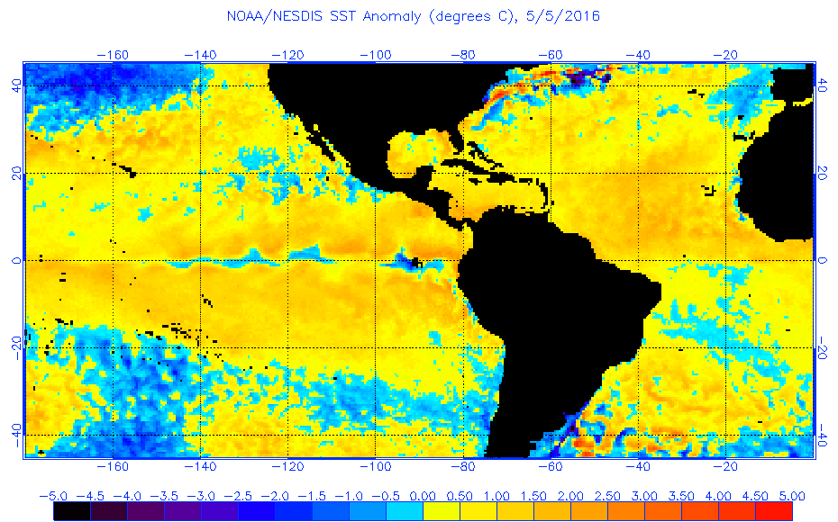
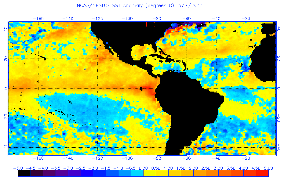
warm SST anomalies continue to become more widespread across the Atlantic basin and now we see even the North Atlantic warming. Compare to just one week ago...


0 likes
-
WPBWeather
- S2K Supporter
- Posts: 535
- Age: 67
- Joined: Thu Jul 18, 2013 12:33 pm
Re: 2016 indicators: Instability / SST's / MSLP / Steering / Sal
gatorcane wrote:warm SST anomalies continue to become more widespread across the Atlantic basin and now we see even the North Atlantic warming. Compare to just one week ago...
http://i.imgur.com/jyQKLVu.gif
http://i.imgur.com/Ux6dq5i.gif
Unless the ice melt catches up soon and cools it down. All will be very interesting to watch in the coming weeks!
0 likes
Re: 2016 indicators: Instability / SST's / MSLP / Steering / Sal
Cooling showing up again on the CDAS charts; might see a return to anomalous warming as the NAO goes negative as it was in late April.

0 likes
-
terstorm1012

- S2K Supporter
- Posts: 1314
- Age: 44
- Joined: Fri Sep 10, 2004 5:36 pm
- Location: Millersburg, PA
Re: 2016 indicators: Instability / SST's / MSLP / Steering / Sal
good catch, andrew92, on 1985. I too am leaning that way now that you've pointed it out.
0 likes
my posts in this forum are NOT official forecast and should not be used as such. They are just my opinion (to which I welcome challenges!) and may or may not be backed by sound meteorological data. They are NOT endorsed by any professional institution or storm2k.org. For official information, please refer to the NHC and NWS products
Re: 2016 indicators: Instability / SST's / MSLP / Steering / Sal
All I know is that the MDR is warmer than this same time in the last 2 years.
0 likes
-
SouthDadeFish

- Professional-Met

- Posts: 2835
- Joined: Thu Sep 23, 2010 2:54 pm
- Location: Miami, FL
- Contact:
Re: 2016 indicators: Instability / SST's / MSLP / Steering / Sal
As Mike Ventrice has pointed out, models are suggesting that there will be a shift in the standing wave of upper-tropospheric velocity potential towards the Indian Ocean within the next few weeks. A convectively active Indian Ocean has been shown to be favorable for ATL TC activity. If the ATL can warm up a little bit more, this season has a solid chance of at least seeing normal levels of activity.
0 likes
-
SFLcane

- S2K Supporter
- Posts: 10281
- Age: 48
- Joined: Sat Jun 05, 2010 1:44 pm
- Location: Lake Worth Florida
Re: 2016 indicators: Instability / SST's / MSLP / Steering / Sal
For those in Florida me (SFL) you might wanna read this interesting article.
Could shifting weather patterns mean more hurricanes?
http://www.orlandosentinel.com/weather/ ... story.html
Could shifting weather patterns mean more hurricanes?
http://www.orlandosentinel.com/weather/ ... story.html
0 likes
-
SFLcane
- S2K Supporter
- Posts: 10281
- Age: 48
- Joined: Sat Jun 05, 2010 1:44 pm
- Location: Lake Worth Florida
Re: 2016 indicators: Instability / SST's / MSLP / Steering / Sal
Michael Lowry via twitter...
Waters across the main development region are the warmest they've been leading into a #hurricane season since 2013.

Waters across the main development region are the warmest they've been leading into a #hurricane season since 2013.
0 likes
-
Kingarabian
- S2K Supporter
- Posts: 16355
- Joined: Sat Aug 08, 2009 3:06 am
- Location: Honolulu, Hawaii
Re: 2016 indicators: Instability / SST's / MSLP / Steering / Sal
Todd Crawford
@tcrawf_nh
New ECMWF seasonal forecast shows enhanced tropical activity near East Coast, reduced activity in MDR
@tcrawf_nh
New ECMWF seasonal forecast shows enhanced tropical activity near East Coast, reduced activity in MDR
0 likes
RIP Kobe Bryant
-
Blown Away

- S2K Supporter
- Posts: 10253
- Joined: Wed May 26, 2004 6:17 am
Re: 2016 indicators: Instability / SST's / MSLP / Steering / Sal
Kingarabian wrote:Todd Crawford
@tcrawf_nh
New ECMWF seasonal forecast shows enhanced tropical activity near East Coast, reduced activity in MDR
0 likes
Hurricane Eye Experience: David 79, Irene 99, Frances 04, Jeanne 04, Wilma 05… Hurricane Brush Experience: Andrew 92, Erin 95, Floyd 99, Matthew 16, Irma 17, Ian 22, Nicole 22…
-
SFLcane
- S2K Supporter
- Posts: 10281
- Age: 48
- Joined: Sat Jun 05, 2010 1:44 pm
- Location: Lake Worth Florida
Re: 2016 indicators: Instability / SST's / MSLP / Steering / Sal
ECMWF essentially a copy of 2015.. dead south of 25n not sure I by that though. Wow so tired of these extremely pessimistic outlooks from various models and agencies wake up when this nightmare over.
0 likes
-
terstorm1012
- S2K Supporter
- Posts: 1314
- Age: 44
- Joined: Fri Sep 10, 2004 5:36 pm
- Location: Millersburg, PA
Re: 2016 indicators: Instability / SST's / MSLP / Steering / Sal
That doesn't mean home-grown systems won't proliferate.
0 likes
-
TheStormExpert
Re: 2016 indicators: Instability / SST's / MSLP / Steering / Sal
Blown Away wrote:Kingarabian wrote:Todd Crawford
@tcrawf_nh
New ECMWF seasonal forecast shows enhanced tropical activity near East Coast, reduced activity in MDR

This far out it is too impossible to know whether there will be more troughiness or ridging along the U.S. East Coast. Lately there seems to be a mix of both.
The way I see the graphic it shows the Mid-Atlantic/Northeast U.S. are at high risk this season of possibly being threatened by a Tropical Cyclone. Also the Western Gulf of Mexico and Texas coastline have a high risk of seeing something if this graphic is worth anything.
0 likes
Who is online
Users browsing this forum: No registered users and 135 guests