2021 EPAC Season
Moderator: S2k Moderators
Forum rules

The posts in this forum are NOT official forecasts and should not be used as such. They are just the opinion of the poster and may or may not be backed by sound meteorological data. They are NOT endorsed by any professional institution or STORM2K. For official information, please refer to products from the National Hurricane Center and National Weather Service.
-
Yellow Evan

- Professional-Met

- Posts: 16240
- Age: 27
- Joined: Fri Jul 15, 2011 12:48 pm
- Location: Henderson, Nevada/Honolulu, HI
- Contact:
Re: 2021 EPAC Season
The back to back landfalling hurricanes modeled by the globals especially GFS remind me of 1996 in particular. Overall SST configuration favors multiple Mexico landfalls this year followed by an El Nino next year.
0 likes
-
Yellow Evan
- Professional-Met
- Posts: 16240
- Age: 27
- Joined: Fri Jul 15, 2011 12:48 pm
- Location: Henderson, Nevada/Honolulu, HI
- Contact:


-
Kingarabian

- S2K Supporter

- Posts: 16365
- Joined: Sat Aug 08, 2009 3:06 am
- Location: Honolulu, Hawaii
Re: 2021 EPAC Season
00z Euro and CMC in 7-10 also have a strong signal for another system to potentially become a hurricane in the east EPAC:
00z Euro:

00z CMC:

Even though the Euro and CMC do not show hurricane pressures, they often underestimate intensity and can be extrapolated.
00z Euro:
00z CMC:
Even though the Euro and CMC do not show hurricane pressures, they often underestimate intensity and can be extrapolated.
0 likes
RIP Kobe Bryant
-
Yellow Evan
- Professional-Met
- Posts: 16240
- Age: 27
- Joined: Fri Jul 15, 2011 12:48 pm
- Location: Henderson, Nevada/Honolulu, HI
- Contact:
Re: 2021 EPAC Season

12z GFS shows a hurricane that peaks south of Guerrero before weakening due to land interaction ala a Beatriz 11.

12z CMC has a slow moving hurricane that meanders offshore.
0 likes
-
Kingarabian
- S2K Supporter
- Posts: 16365
- Joined: Sat Aug 08, 2009 3:06 am
- Location: Honolulu, Hawaii
Re: 2021 EPAC Season
12z Euro also continues to show it, but has been hinting on a broad system.

I think the NHC will circle it on Monday.
I think the NHC will circle it on Monday.
0 likes
RIP Kobe Bryant
-
Yellow Evan
- Professional-Met
- Posts: 16240
- Age: 27
- Joined: Fri Jul 15, 2011 12:48 pm
- Location: Henderson, Nevada/Honolulu, HI
- Contact:
Re: 2021 EPAC Season

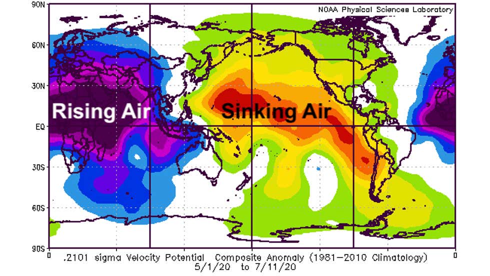
As shown by the CFS earlier this year, the -PDO may be starting to weaken.
2 likes
-
Kingarabian
- S2K Supporter
- Posts: 16365
- Joined: Sat Aug 08, 2009 3:06 am
- Location: Honolulu, Hawaii
Re: 2021 EPAC Season
Yellow Evan wrote:[url]https://cdn.discordapp.com/attachments/733552978572869632/855551824932503582/Screen_Shot_2021-06-18_at_4.57.25_PM.png[url]
As shown by the CFS earlier this year, the -PDO may be starting to weaken.
This -PDO weakening is also visible on CDAS and OISST. Interesting developments considering it's June. This proceeds the natural summer time SST warming, which I think really takes off in July and peaks by October. So we could see the PDO warm further.
1 likes
RIP Kobe Bryant
-
Nancy Smar

- Category 5

- Posts: 1081
- Age: 25
- Joined: Wed Aug 16, 2017 10:03 pm
Re: 2021 EPAC Season
GENESIS008, EP, E, , , , , 78, 2021, DB, O, 2021061818, 9999999999, , 008, , , , GENESIS, , EP782021
0 likes
-
Yellow Evan
- Professional-Met
- Posts: 16240
- Age: 27
- Joined: Fri Jul 15, 2011 12:48 pm
- Location: Henderson, Nevada/Honolulu, HI
- Contact:
Re: 2021 EPAC Season

0z GFS showing a hurricane that peaks west of Soccoro Island. Somewhat of a long tracker.
0 likes
-
Yellow Evan
- Professional-Met
- Posts: 16240
- Age: 27
- Joined: Fri Jul 15, 2011 12:48 pm
- Location: Henderson, Nevada/Honolulu, HI
- Contact:
Re: 2021 EPAC Season
https://twitter.com/webberweather/status/1406212287124279303
https://twitter.com/andyhazelton/status/1406219096295870464
After a busy June, wouldn’t rule out a historically inactive July.
https://twitter.com/andyhazelton/status/1406219096295870464
After a busy June, wouldn’t rule out a historically inactive July.
0 likes

Re: 2021 EPAC Season
Yellow Evan wrote:https://twitter.com/webberweather/status/1406212287124279303?s=21
https://twitter.com/andyhazelton/status/1406219096295870464?s=21
After a busy June, wouldn’t rule out a historically inactive July.
Wouldn’t the mass subsidence over the IO also mean an inactive Atlantic depending on how long it lasts?
0 likes
Irene '11 Sandy '12 Hermine '16 5/15/2018 Derecho Fay '20 Isaias '20 Elsa '21 Henri '21 Ida '21
I am only a meteorology enthusiast who knows a decent amount about tropical cyclones. Look to the professional mets, the NHC, or your local weather office for the best information.
I am only a meteorology enthusiast who knows a decent amount about tropical cyclones. Look to the professional mets, the NHC, or your local weather office for the best information.
-
Yellow Evan
- Professional-Met
- Posts: 16240
- Age: 27
- Joined: Fri Jul 15, 2011 12:48 pm
- Location: Henderson, Nevada/Honolulu, HI
- Contact:
Re: 2021 EPAC Season
aspen wrote:Yellow Evan wrote:https://twitter.com/webberweather/status/1406212287124279303?s=21
https://twitter.com/andyhazelton/status/1406219096295870464?s=21
After a busy June, wouldn’t rule out a historically inactive July.
Wouldn’t the mass subsidence over the IO also mean an inactive Atlantic depending on how long it lasts?
To a certain extent yes but there’s also somewhat of an ASW pattern evident.
0 likes
-
Yellow Evan
- Professional-Met
- Posts: 16240
- Age: 27
- Joined: Fri Jul 15, 2011 12:48 pm
- Location: Henderson, Nevada/Honolulu, HI
- Contact:


-
Yellow Evan
- Professional-Met
- Posts: 16240
- Age: 27
- Joined: Fri Jul 15, 2011 12:48 pm
- Location: Henderson, Nevada/Honolulu, HI
- Contact:

-
Kingarabian
- S2K Supporter
- Posts: 16365
- Joined: Sat Aug 08, 2009 3:06 am
- Location: Honolulu, Hawaii
Re: 2021 EPAC Season
aspen wrote:Yellow Evan wrote:https://twitter.com/webberweather/status/1406212287124279303?s=21
https://twitter.com/andyhazelton/status/1406219096295870464?s=21
After a busy June, wouldn’t rule out a historically inactive July.
Wouldn’t the mass subsidence over the IO also mean an inactive Atlantic depending on how long it lasts?
For now it means a 2020 repeat is unlikely. The ASW and a slow EPAC hurricane season can still allow the Atlantic to have an active season though.
0 likes
RIP Kobe Bryant
Re: 2021 EPAC Season
Kingarabian wrote:aspen wrote:Yellow Evan wrote:https://twitter.com/webberweather/status/1406212287124279303?s=21
https://twitter.com/andyhazelton/status/1406219096295870464?s=21
After a busy June, wouldn’t rule out a historically inactive July.
Wouldn’t the mass subsidence over the IO also mean an inactive Atlantic depending on how long it lasts?
For now it means a 2020 repeat is unlikely. The ASW and a slow EPAC hurricane season can still allow the Atlantic to have an active season though.
I thought that the African Standing Wave and the rising motion over Africa/the IO were one of the same.
0 likes
Irene '11 Sandy '12 Hermine '16 5/15/2018 Derecho Fay '20 Isaias '20 Elsa '21 Henri '21 Ida '21
I am only a meteorology enthusiast who knows a decent amount about tropical cyclones. Look to the professional mets, the NHC, or your local weather office for the best information.
I am only a meteorology enthusiast who knows a decent amount about tropical cyclones. Look to the professional mets, the NHC, or your local weather office for the best information.
-
Kingarabian
- S2K Supporter
- Posts: 16365
- Joined: Sat Aug 08, 2009 3:06 am
- Location: Honolulu, Hawaii
Re: 2021 EPAC Season
aspen wrote:Kingarabian wrote:aspen wrote:Wouldn’t the mass subsidence over the IO also mean an inactive Atlantic depending on how long it lasts?
For now it means a 2020 repeat is unlikely. The ASW and a slow EPAC hurricane season can still allow the Atlantic to have an active season though.
I thought that the African Standing Wave and the rising motion over Africa/the IO were one of the same.
They can be connected in La Nina years, but in non La Nina years it's usually predominately over and around Africa. 2020 for example had a dominant ASW that slowly transitioned to the IO and then the MC.
https://twitter.com/MJVentrice/status/1331716905326030853
1 likes
RIP Kobe Bryant
-
Yellow Evan
- Professional-Met
- Posts: 16240
- Age: 27
- Joined: Fri Jul 15, 2011 12:48 pm
- Location: Henderson, Nevada/Honolulu, HI
- Contact:

-
cycloneye

- Admin

- Posts: 149505
- Age: 69
- Joined: Thu Oct 10, 2002 10:54 am
- Location: San Juan, Puerto Rico
Re: 2021 EPAC Season
The 00z Euro.

0 likes
Visit the Caribbean-Central America Weather Thread where you can find at first post web cams,radars
and observations from Caribbean basin members Click Here
and observations from Caribbean basin members Click Here
Re: 2021 EPAC Season
I wonder how long it’ll take for the EPac to produce its first operational hurricane. Dolores could get upgraded in post-season analysis, but since it wasn’t an operational hurricane, it won’t count for now.
0 likes
Irene '11 Sandy '12 Hermine '16 5/15/2018 Derecho Fay '20 Isaias '20 Elsa '21 Henri '21 Ida '21
I am only a meteorology enthusiast who knows a decent amount about tropical cyclones. Look to the professional mets, the NHC, or your local weather office for the best information.
I am only a meteorology enthusiast who knows a decent amount about tropical cyclones. Look to the professional mets, the NHC, or your local weather office for the best information.
Who is online
Users browsing this forum: NotSparta and 239 guests