Analysis,Models,Sat Pics of Low in Western Atlantic

This is the general tropical discussion area. Anyone can take their shot at predicting a storms path.

Moderator: S2k Moderators

Forum rules

The posts in this forum are NOT official forecasts and should not be used as such. They are just the opinion of the poster and may or may not be backed by sound meteorological data. They are NOT endorsed by any professional institution or STORM2K. For official information, please refer to products from the National Hurricane Center and National Weather Service.

Help Support Storm2K
Message
Author
User avatar
HURAKAN
Professional-Met
Professional-Met
Posts: 46086
Age: 38
Joined: Thu May 20, 2004 4:34 pm
Location: Key West, FL
Contact:

#361 Postby HURAKAN » Tue May 08, 2007 6:24 am

Image

lOOKING BETTER.
0 likes   

User avatar
cycloneye
Admin
Admin
Posts: 145270
Age: 68
Joined: Thu Oct 10, 2002 10:54 am
Location: San Juan, Puerto Rico

#362 Postby cycloneye » Tue May 08, 2007 6:26 am

...SPECIAL FEATURE...

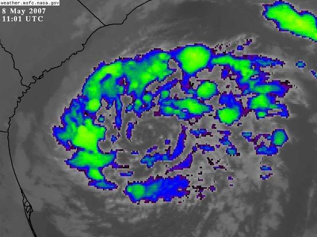
AN OCCLUDED 1001 MB SFC LOW WAS LOCATED NEAR 30.5N 76.5W AT
08/0900 UTC...OR ABOUT 250NM E OF THE FLORIDA/GEORGIA
BORDER...MOVING W AT ABOUT 10 KT. A STORM WARNING ASSOCIATED
WITH THIS SYSTEM IS IN AFFECT FOR THE OFFSHORE AREA N OF 29N W
OF 76W BUT IS EXPECTED TO RELAX TO GALE CONDITIONS THROUGH THE
DAY. THIS WAS VERIFIED BY LAST EVENINGS QUIKSCAT PASS WHICH
SHOWED 50-60 KT WINDS OFF THE SOUTHEAST COAST. THESE WINDS ARE
CONTINUING TO PRODUCE A SIGNIFICANT SWELL EVENT FOR THE
SOUTHEAST U.S. COAST AND THE BAHAMAS. BUOY 41010 HAS BEEN
REPORTING 20-25 FT SEAS AT 16 SEC OVER THE LAST SEVERAL HOURS.
THE REGIONAL WW3 MODEL NOW SEEMS ON TRACK WITH THE HEIGHTS BUT
CONTINUES TO UNDERESTIMATE THE PERIODS WHICH WILL FURTHER ADD TO
THE BREAKING WAVE HEIGHTS UPON SHOALING. LIGHTNING DATA HAS BEEN
DEPICTING SCATTERED TSTMS IN THE MODERATE CONVECTION SEEN WITHIN
150NM N AND W OF THE CENTER. THE MAIN THREAT...HOWEVER...WILL
CONTINUE TO BE THE HIGH WINDS AND WAVES ASSOCIATED WITH THE
SYSTEM. THE MODEL CONSENSUS IS TO CONTINUE MOVING THE LOW
TOWARDS NORTH FLORIDA/GEORGIA OVER THE NEXT DAY OR SO WHILE
SLOWLY WEAKENING. PLEASE REFER TO THE HIGH SEAS FORECASTS AND
STATEMENTS FROM LOCAL WEATHER FORECAST OFFICES FOR MORE DETAILS
REGARDING EXPECTED OFFSHORE AND COASTAL IMPACTS.

http://www.storm2k.org/wx/modules.php?n ... ge&pid=109

The above is the 8 AM Special Feature discussion from TPC.
0 likes   
Visit the Caribbean-Central America Weather Thread where you can find at first post web cams,radars
and observations from Caribbean basin members Click Here

User avatar
Zadok
Tropical Storm
Tropical Storm
Posts: 232
Joined: Sun Aug 29, 2004 7:32 am
Location: USA East Coast

#363 Postby Zadok » Tue May 08, 2007 6:42 am

Image
0 likes   

User avatar
Extremeweatherguy
Category 5
Category 5
Posts: 11095
Joined: Mon Oct 10, 2005 8:13 pm
Location: Florida

#364 Postby Extremeweatherguy » Tue May 08, 2007 6:57 am

looks interesting this morning. Seems like more convection is trying to form and wrap around the center.
0 likes   

User avatar
NDG
S2K Supporter
S2K Supporter
Posts: 15446
Joined: Sun Jul 09, 2006 10:14 pm
Location: Orlando, FL

#365 Postby NDG » Tue May 08, 2007 7:02 am

Hmm, it looks much better this morning, the low pressure area seems it has detached itself from the cold front, it doesn't look extratropical like it did yesterday, surface temps around the center are in the to low 70s, much warmer than yesterday, and dewpoints are up at least in the mid 60s. Lets see what happens when it crosses the warmest part of the gulfstream later on. A little more convection during the day and There's such a small window of opportunity that I'm wondering if the NHC will even bother in upgrading it to a subtropical system if it does before the window closes up.
0 likes   

CrazyC83
Professional-Met
Professional-Met
Posts: 34002
Joined: Tue Mar 07, 2006 11:57 pm
Location: Deep South, for the first time!

#366 Postby CrazyC83 » Tue May 08, 2007 7:05 am

That looks like a subtropical or tropical storm now except for the lack of continuous convection...
0 likes   

User avatar
WmE
Category 2
Category 2
Posts: 696
Age: 36
Joined: Sat Jun 17, 2006 11:23 am
Location: Vienna, Austria

#367 Postby WmE » Tue May 08, 2007 7:06 am

CrazyC83 wrote:That looks like a subtropical or tropical storm now except for the lack of continuous convection...


Yeah I agree. This system looks really interesting.
0 likes   

User avatar
Chacor
Category 5
Category 5
Posts: 10229
Joined: Mon Oct 02, 2006 10:43 pm
Location: Singapore

#368 Postby Chacor » Tue May 08, 2007 7:14 am

08/1145 UTC 30.3N 77.5W ST2.5/2.5 90L -- Atlantic Ocean
0 likes   

User avatar
skysummit
S2K Supporter
S2K Supporter
Posts: 5305
Age: 49
Joined: Tue Aug 31, 2004 11:09 pm
Location: Ponchatoula, LA
Contact:

#369 Postby skysummit » Tue May 08, 2007 7:33 am

The best thing to do with this is pretend it's the real deal. What if this was a Cat 4 getting ready to slowly cross the gulf stream? What if this was the big one getting ready to slam into the east coast? Would you be ready?
0 likes   

User avatar
cycloneye
Admin
Admin
Posts: 145270
Age: 68
Joined: Thu Oct 10, 2002 10:54 am
Location: San Juan, Puerto Rico

#370 Postby cycloneye » Tue May 08, 2007 7:35 am

Image

The good news about this low is as it moves towards the Georgia/Florida states,it will aliviate the drought and fire situations there.
0 likes   

tgenius
S2K Supporter
S2K Supporter
Posts: 1160
Joined: Mon May 15, 2006 5:31 pm
Location: Miami, FL

#371 Postby tgenius » Tue May 08, 2007 7:40 am

With the amount of convection firing on the left side of the low, it looks like it may just bring some rain to Miami after all ;)
0 likes   

User avatar
Weatherfreak14
Category 5
Category 5
Posts: 1383
Joined: Sat Sep 24, 2005 3:40 pm
Location: Beaufort, SC
Contact:

#372 Postby Weatherfreak14 » Tue May 08, 2007 7:50 am

It looks as if parts of SE SC is going to get some very much needed rain in the area and surf. im heading out to surf later today.
0 likes   

User avatar
GeneratorPower
S2K Supporter
S2K Supporter
Posts: 1648
Age: 45
Joined: Sun Dec 18, 2005 11:48 pm
Location: Huntsville, AL

#373 Postby GeneratorPower » Tue May 08, 2007 8:09 am

This has oodles of possibility to be the "unnamed subtropical storm of May 2007". This is just the type of system they upgrade after the season is over.
0 likes   

User avatar
Noah
S2K Supporter
S2K Supporter
Posts: 541
Joined: Fri Sep 24, 2004 10:41 am
Location: Sarasota FL

#374 Postby Noah » Tue May 08, 2007 8:11 am

WHen is the time frame they expect this to move into florida?
0 likes   

User avatar
cycloneye
Admin
Admin
Posts: 145270
Age: 68
Joined: Thu Oct 10, 2002 10:54 am
Location: San Juan, Puerto Rico

#375 Postby cycloneye » Tue May 08, 2007 8:12 am

GeneratorPower wrote:This has oodles of possibility to be the "unnamed subtropical storm of May 2007". This is just the type of system they upgrade after the season is over.


Agree on that.After reanalysis they may do it.
0 likes   
Visit the Caribbean-Central America Weather Thread where you can find at first post web cams,radars
and observations from Caribbean basin members Click Here

seahawkjd
S2K Supporter
S2K Supporter
Posts: 632
Joined: Wed Sep 10, 2003 4:12 pm
Location: Morehead City, NC
Contact:

#376 Postby seahawkjd » Tue May 08, 2007 8:13 am

The Weather Channel is now calling it a subtropical storm and saying there is the possibility that the Hurricane Center might name it.
0 likes   

miamicanes177
Category 5
Category 5
Posts: 1131
Joined: Tue Aug 01, 2006 10:53 pm

#377 Postby miamicanes177 » Tue May 08, 2007 8:19 am

The NHC will typically not name an early system like this out of fear of causing mass panic. If the public hears about a tropical storm in May it will cause them to worry about how bad the rest of the season might be. They'll wait until after the season to upgrade it unless it is blatantly obvious and they are forced to name it.
0 likes   

User avatar
cycloneye
Admin
Admin
Posts: 145270
Age: 68
Joined: Thu Oct 10, 2002 10:54 am
Location: San Juan, Puerto Rico

#378 Postby cycloneye » Tue May 08, 2007 8:26 am

NOUS42 KNHC 081330
WEATHER RECONNAISSANCE FLIGHTS
CARCAH, NATIONAL HURRICANE CENTER, MIAMI, FL.
0930 AM EDT TUE 08 MAY 2007
SUBJECT: TROPICAL CYCLONE PLAN OF THE DAY (WSPOD)
VALID 09/1100Z 10/1100Z MAY 2007
WSPOD NUMBER.....07-001

I. ATLANTIC REQUIREMENTS
1. FLIGHT ONE AREA OFF SOUTH CAROLINA
A. 09/1200Z
B. AFXXX 01AAA INVEST
C. 09/0930Z
D. 31.8N 79.4W
E. 09/1100Z-09/1800Z
F. SFC TO 10,000FT

2. OUTLOOK FOR SUCCEEDING DAY.....NEGATIVE.

http://asp1.sbs.ohio-state.edu/text/tro ... OUS42.KNHC

It's for tommorow morning at 12:00z or 8:00 AM EDT.If necessary.This assures that invest 90L will apear at NRL later today.
Last edited by cycloneye on Tue May 08, 2007 8:30 am, edited 2 times in total.
0 likes   
Visit the Caribbean-Central America Weather Thread where you can find at first post web cams,radars
and observations from Caribbean basin members Click Here

User avatar
Nimbus
Category 5
Category 5
Posts: 5300
Joined: Mon Jul 19, 2004 10:54 am

#379 Postby Nimbus » Tue May 08, 2007 8:29 am

Is the track progged to continue west with a little southerly component or is the next trough going to pull it back out over the gulf stream before the center gets over land?
0 likes   

User avatar
wxman57
Moderator-Pro Met
Moderator-Pro Met
Posts: 22976
Age: 67
Joined: Sat Jun 21, 2003 8:06 pm
Location: Houston, TX (southwest)

#380 Postby wxman57 » Tue May 08, 2007 8:31 am

Winds around the low have dropped considerably since yesterday - down to 25-35 kts now. Note all the cool, dry air surrounding the low center and flowing off the SE US Coast. There's not much tropical about this low. Winds along coastal counties of Georgia and SC won't be too strong, but the area may get a little rain.

Image
0 likes   


Return to “Talkin' Tropics”

Who is online

Users browsing this forum: No registered users and 32 guests