system is not recon worthy.
If recon would fly anything, it would be flying Cosme
Tropical Wave in Western Caribbean
Moderator: S2k Moderators
Forum rules

The posts in this forum are NOT official forecasts and should not be used as such. They are just the opinion of the poster and may or may not be backed by sound meteorological data. They are NOT endorsed by any professional institution or STORM2K. For official information, please refer to products from the National Hurricane Center and National Weather Service.
-
Aric Dunn
- Category 5

- Posts: 21238
- Age: 43
- Joined: Sun Sep 19, 2004 9:58 pm
- Location: Ready for the Chase.
- Contact:
Re: Strong Tropical Wave in Eastern Caribbean
Derek Ortt wrote:system is not recon worthy.
If recon would fly anything, it would be flying Cosme
who said it was?
0 likes
-
Aric Dunn
- Category 5
- Posts: 21238
- Age: 43
- Joined: Sun Sep 19, 2004 9:58 pm
- Location: Ready for the Chase.
- Contact:
Re: Strong Tropical Wave in Eastern Caribbean
thats interesting ,.. the wave axis was adjusted further east..

notice the northern portion
notice the northern portion
0 likes
-
DrewFL
Re: Strong Tropical Wave in Eastern Caribbean
Yeah, Aric, I noticed the northern part. What?
0 likes
-
knotimpaired

- Category 1

- Posts: 495
- Joined: Fri May 20, 2005 4:14 am
- Location: Vieques, PR
- Contact:
-
Aric Dunn
- Category 5
- Posts: 21238
- Age: 43
- Joined: Sun Sep 19, 2004 9:58 pm
- Location: Ready for the Chase.
- Contact:
Re: Strong Tropical Wave in Eastern Caribbean
DrewFL wrote:Yeah, Aric, I noticed the northern part. What?
sorry .. i was looking for the previous analysis.. but could nt find it.. but anyway.. they have a much more pronounced wave axis.. or sharper wind switch i guess you could say.. and the 1012 mb is further north..
but not a big about that.
the the fact that its analyzed further east.. is the important thing.. either its moving slower than they though and just adjusted it or something else..
i dunno .. just though i would post it
0 likes
-
DrewFL
Re: Strong Tropical Wave in Eastern Caribbean
Far as I know the lower pressures are way south towards Venezuela. The scalloped thunderstorms on that chart up above PR reflect just that. Thunderstorms. I see nothing else and I don't need to post any charts or links to back that up either.
0 likes
-
Aric Dunn
- Category 5
- Posts: 21238
- Age: 43
- Joined: Sun Sep 19, 2004 9:58 pm
- Location: Ready for the Chase.
- Contact:
Re: Strong Tropical Wave in Eastern Caribbean
DrewFL wrote:Far as I know the lower pressures are way south towards Venezuela. The scalloped thunderstorms on that chart up above PR reflect just that. Thunderstorms. I see nothing else and I don't need to post any charts or links to back that up either.
well the NHC .. say different.. yeah the Convection is to the north.. but they have the 1012mb isobar much farther north...
i know what you mean i cant find 1012 except farther south.. but they have it just south of PR..
was just interested in why they did that as well as re adjusted the wave axis east quite a bit..
guess they have better data... ( i would hope so ) anyway
and you should always post .. all available data .. too support your thoughts..
0 likes

Re: Strong Tropical Wave in Eastern Caribbean
Question I have is the wave really moving WNW or being pulled north into the ULL?
0 likes
-
Aric Dunn
- Category 5
- Posts: 21238
- Age: 43
- Joined: Sun Sep 19, 2004 9:58 pm
- Location: Ready for the Chase.
- Contact:
Re: Strong Tropical Wave in Eastern Caribbean
well nevermind .. found plenty of observations here to support the lower pressure further north..
0 likes
-
Aric Dunn
- Category 5
- Posts: 21238
- Age: 43
- Joined: Sun Sep 19, 2004 9:58 pm
- Location: Ready for the Chase.
- Contact:
Re: Strong Tropical Wave in Eastern Caribbean
boca wrote:Question I have is the wave really moving WNW or being pulled north into the ULL?
the wave itself is moving west to wnw yeah . the convection is getting pulled a little further north..
0 likes
-
DrewFL
Re: Strong Tropical Wave in Eastern Caribbean
Just to (correct spelling) I submit this Aric:
AREA FORECAST DISCUSSION
NATIONAL WEATHER SERVICE SAN JUAN PR
1058 PM AST THU JUL 19 2007
.UPDATE...THE TROPICAL WAVE IN THE VICINITY OF THE LOCAL ISLANDS
WILL CONTINUE TO MOVE SLOWLY TOWARD THE WEST-NORTHWEST. SATELLITE
IMAGERY SHOWED ABUNDANT CLOUDS THIS EVENING BUT MOST OF THE SHOWER
ACTIVITY REMAINED OVER THE WATERS. ADDITION AL BANDS OF SHOWERS
ARE EXPECTED OVERNIGHT OVER THE EAST AND SOUTHEAST SECTIONS OF
PUERTO RICO...CULEBRA..VIEQUES AND THE U.S. VIRGIN ISLANDS.
THE CHANCES FOR PRECIPITATION WILL REMAIN HIGH WHILE THE MOISTURE
ASSOCIATED TO THE WAVE LINGERS IN THE AREA. MINOR CHANGES TO GRIDS
WERE DONE.
0 likes
-
Aric Dunn
- Category 5
- Posts: 21238
- Age: 43
- Joined: Sun Sep 19, 2004 9:58 pm
- Location: Ready for the Chase.
- Contact:
Re: Strong Tropical Wave in Eastern Caribbean
bouy 42059 .. was at 1010 to 1011.. but has risen to 1012..
which supports the NHC analysis..

which supports the NHC analysis..
0 likes
-
Aric Dunn
- Category 5
- Posts: 21238
- Age: 43
- Joined: Sun Sep 19, 2004 9:58 pm
- Location: Ready for the Chase.
- Contact:
Re: Strong Tropical Wave in Eastern Caribbean
DrewFL wrote:Just to (correct spelling) I submit this Aric:
AREA FORECAST DISCUSSION
NATIONAL WEATHER SERVICE SAN JUAN PR
1058 PM AST THU JUL 19 2007
.UPDATE...THE TROPICAL WAVE IN THE VICINITY OF THE LOCAL ISLANDS
WILL CONTINUE TO MOVE SLOWLY TOWARD THE WEST-NORTHWEST. SATELLITE
IMAGERY SHOWED ABUNDANT CLOUDS THIS EVENING BUT MOST OF THE SHOWER
ACTIVITY REMAINED OVER THE WATERS. ADDITION AL BANDS OF SHOWERS
ARE EXPECTED OVERNIGHT OVER THE EAST AND SOUTHEAST SECTIONS OF
PUERTO RICO...CULEBRA..VIEQUES AND THE U.S. VIRGIN ISLANDS.
THE CHANCES FOR PRECIPITATION WILL REMAIN HIGH WHILE THE MOISTURE
ASSOCIATED TO THE WAVE LINGERS IN THE AREA. MINOR CHANGES TO GRIDS
WERE DONE.
huh? correct spelling
0 likes


Re: Strong Tropical Wave in Eastern Caribbean
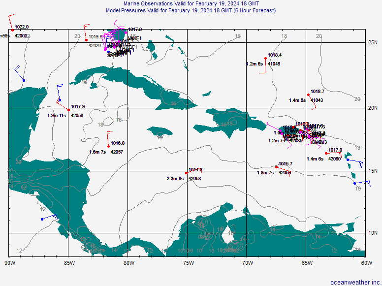
Convection has died down in the area as it tends to do in the tropics at this time before refiring again just before dawn. And as they usually do at this time of the day too, pressures are falling, with the lowest pressures of 1010-1011 mb in the vicinity of about 100-150 miles south-south-east of Puerto Rico. This is an area to watch in a few hours when storms refire. If they refire in this area in a big way, a low-level circulation may develop quickly. Interestingly, looking at the ship reports, there is one coming from 35 miles east of St. Croix--which is an area that had the most persistent convection today, and has dropped almost three mb in pressure over the last hour (to 1012)--this ship is reporting a due east wind of 37 knots (42 mph). It may be just a fluke--the result of a thunderstorm or just a rogue gust, but it would be interesting to see if similar reports come out.
DAY/ ID Latit Longit Temp Dewp Wind Gust MaxGst Press PTend SeaT Wvht WvPd FULLID
HOUR (-degrees-) (---C---) (---degr/knots---) (millibars) (C) (m) (s) ---------------------------------------------------------------------------------------
20/06 42056 19.9 -85.1 29.0 24.2 080 8 G 10 080 12 1014.7 -0.4 29.9 0.5 8 42056
20/06 42059 15.0 -67.5 28.1 25.2 090 10 G 12 090 14 1012.1 -1.4 28.6 1.5 9 42059
20/06 C6FV9 20.0 -84.5 29.0 050 10 1015.0 -1.0 29.0 C6FV9
20/06 C6LU4 17.7 -68.7 27.0 070 15 1014.0 0.0 C6LU4
20/06 C6VY5 20.4 -84.3 27.0 26.2 100 10 1015.0 -1.0 30.0 C6VY5
20/06 ELQJ3 12.6 -64.0 26.4 090 5 1016.7 1.0 30.0 ELQJ3
20/06 ELYP7 20.7 -83.3 28.0 25.3 070 8 1019.3 0.0 27.0 ELYP7
20/06 H3VT 18.0 -87.5 26.0 080 13 1016.0 0.0 30.0 H3VT
20/06 J8PB 17.9 -64.0 28.0 23.0 090 37 1012.5 -2.5 J8PB
20/06 MINFR 10.8 -65.5 25.8 1011.7 -1.5 MINFR02
20/06 PHQX 12.5 -70.7 25.2 22.4 090 10 1011.5 -1.5 PHQX
20/06 SHIP 14.9 -72.5 27.6 26.3 100 15 1011.8 -0.6 28.7 SHIP
0 likes
-
Complacency
- Tropical Low

- Posts: 22
- Joined: Thu Jul 19, 2007 3:58 pm
Re: Strong Tropical Wave in Eastern Caribbean
Matt-hurricanewatcher wrote:Complacency wrote:Maybe the Weather Modification Bill S.517 (http://www.govtrack.us/congress/billtex ... l=s109-517) is actually helping us out here...maybe chemtrails (http://www.newswithviews.com/guest_opinion/guest81.htm) are necessary for fighting potential tropical development besides Saharan dust.
Hey dynomat, it is not you that is keeping things quite this season. Its shear, that is above normal. I think it would be a good thing for a few tropical storms to form.
Did I say that it was "I" who was keeping things quiet this season??? No! All I was suggesting is that maybe our government is running covert experiments over any areas of possible tropical development (especially any tropical threats to the mainland U.S.) without any public debate or overall public consensus.
Hey DynoMATT, did you see the links I posted to the weather modification bill and the chemtrail theory (which suggests that more than weather modification is taking place)?!
0 likes
-
wxman57

- Moderator-Pro Met

- Posts: 23175
- Age: 68
- Joined: Sat Jun 21, 2003 8:06 pm
- Location: Houston, TX (southwest)
Re: Strong Tropical Wave in Eastern Caribbean
The wave axis is now along 70W. Oh, and that "bump" you saw on the NWS analysis represented an error by the person doing the analysis. He was trying to account for another bad ship report of 1010.2mb right in the middle of a number of 1016mb reports. Should have thrown that pressure report out. Ship reports are notoriously bad. So, lowest pressures are now southwest of the buoy that's located at 15N/67.5W, as indicated on the map below. Note that pressures are lowest toward the coast of Venezuela and highest north along the wave to near the upper-level trof.
There are no longer any thunderstorms along the wave axis (rather, just east of it). The thunderstorms that were over the NE Caribbean last night just east of the wave axis moved off to the northeast along the upper-level ltrof. They'll be drawn into the upper-level low (as moisture) over the next 24 hours and the wave axis should continue moving westward with little convection until it reaches the Yucatan/Central America early next week. No invest today - it was more impressive yesterday afternoon than it is now.

Here's a water vapor image showing the upper-level features better:

There are no longer any thunderstorms along the wave axis (rather, just east of it). The thunderstorms that were over the NE Caribbean last night just east of the wave axis moved off to the northeast along the upper-level ltrof. They'll be drawn into the upper-level low (as moisture) over the next 24 hours and the wave axis should continue moving westward with little convection until it reaches the Yucatan/Central America early next week. No invest today - it was more impressive yesterday afternoon than it is now.
Here's a water vapor image showing the upper-level features better:
0 likes

Re: Strong Tropical Wave in Eastern Caribbean
Looks like most of the energy in the northern part of the wave is being sheared NNW. If the shear had been less something could have developed there over night but of course it would only be a fish due to the ULL.
No convection on the southern part of the wave this morning but still some low surface pressures around. Not worth blob watching till this afternoon. I still get this feeling the phantom is lurking down there unseen in the satellite imagery. Maybe he only shows himself at sunset?
No convection on the southern part of the wave this morning but still some low surface pressures around. Not worth blob watching till this afternoon. I still get this feeling the phantom is lurking down there unseen in the satellite imagery. Maybe he only shows himself at sunset?
0 likes
Who is online
Users browsing this forum: No registered users and 275 guests