2021 Indicators: SST's / SAL / MSLP / Shear / Steering / Instability / Sat Images
Moderator: S2k Moderators
Forum rules

The posts in this forum are NOT official forecasts and should not be used as such. They are just the opinion of the poster and may or may not be backed by sound meteorological data. They are NOT endorsed by any professional institution or STORM2K. For official information, please refer to products from the National Hurricane Center and National Weather Service.
-
tolakram
- Admin

- Posts: 20186
- Age: 62
- Joined: Sun Aug 27, 2006 8:23 pm
- Location: Florence, KY (name is Mark)
Re: 2021 Indicators: SST's / SAL / MSLP / Shear / Steering / Instability / Sat Images
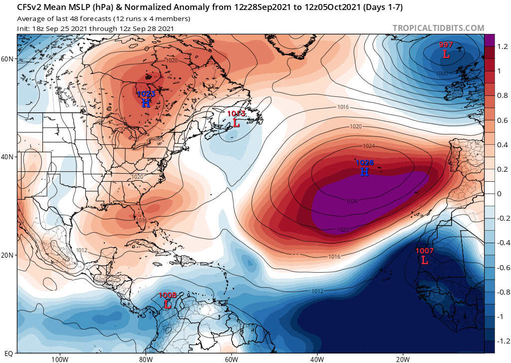
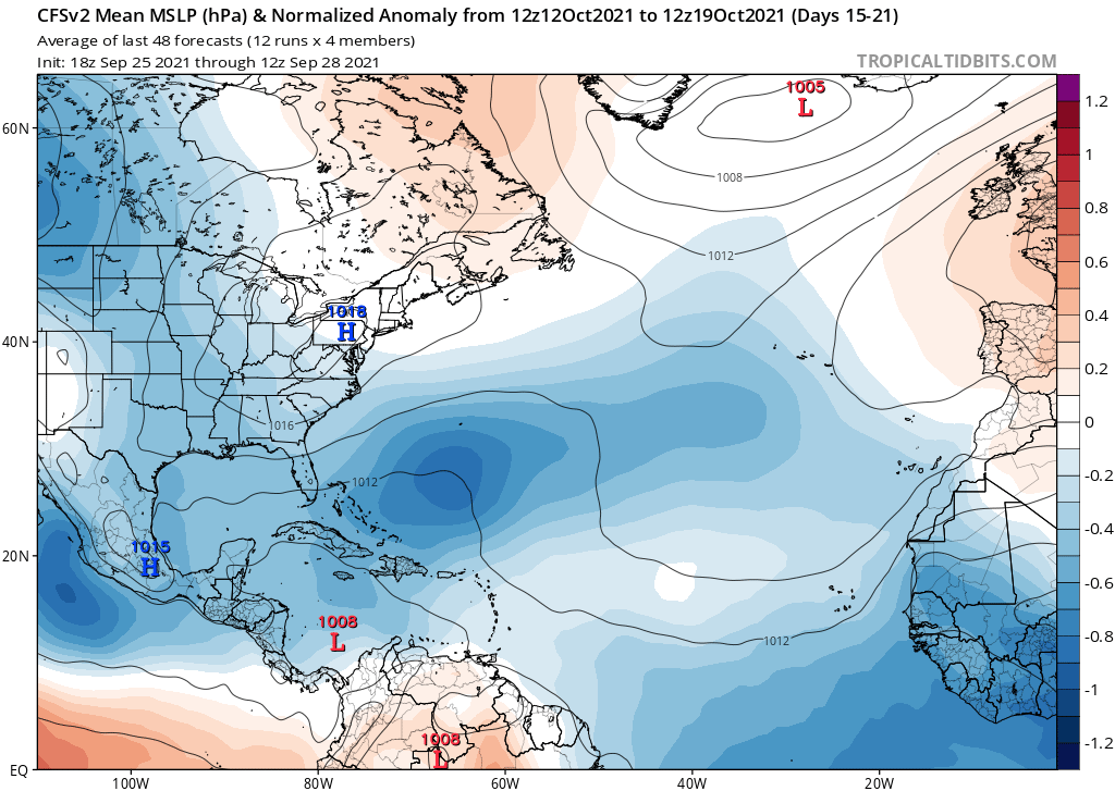
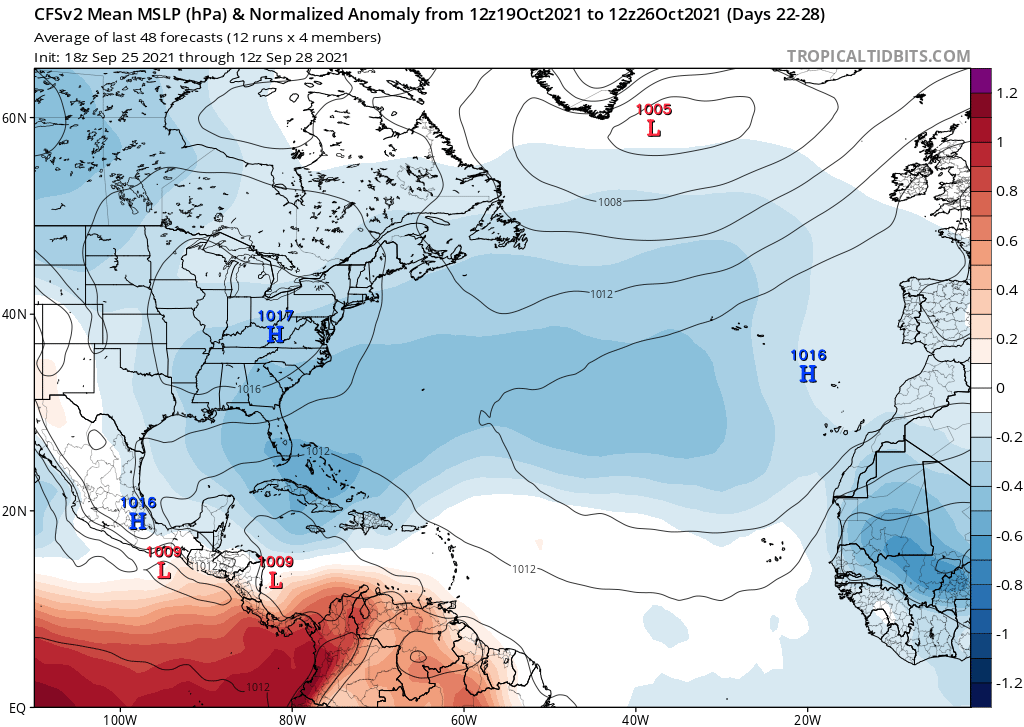
I really wish Hammy could post CFS predictions without having to put up with 'CFS is crap' posts EVERY SINGLE TIME. Some of you obviously didn't do your homework. Regardless, I think CFS predictions and verifications are extremely interesting.
7 likes
M a r k
- - - - -
Join us in chat: Storm2K Chatroom Invite. Android and IOS apps also available.
The posts in this forum are NOT official forecasts and should not be used as such. Posts are NOT endorsed by any professional institution or STORM2K.org. For official information and forecasts, please refer to NHC and NWS products.

Re: 2021 Indicators: SST's / SAL / MSLP / Shear / Steering / Instability / Sat Images
I recall that the CFS usually isn’t the best for forecasting the western basin. Regardless, it did sniff out a late August Gulf major about a month in advanced that verified in the form of Ida, and its predictions of a September carried by long-trackers at opposite ends of the month also verified. Perhaps a reason it’s showing no activity in the WCar is due to the Atlantic Niño fueling late-season eastern MDR activity, stopping waves from getting further west. However, with the Kelvin Wave coming in to give the Atlantic a week-long break, there’s the opportunity for waves to slip by into the western part of the basin.
0 likes
Irene '11 Sandy '12 Hermine '16 5/15/2018 Derecho Fay '20 Isaias '20 Elsa '21 Henri '21 Ida '21
I am only a meteorology enthusiast who knows a decent amount about tropical cyclones. Look to the professional mets, the NHC, or your local weather office for the best information.
I am only a meteorology enthusiast who knows a decent amount about tropical cyclones. Look to the professional mets, the NHC, or your local weather office for the best information.
-
AlphaToOmega
- Category 5

- Posts: 1448
- Joined: Sat Jun 26, 2021 10:51 am
- Location: Somewhere in Massachusetts
Re: 2021 Indicators: SST's / SAL / MSLP / Shear / Steering / Instability / Sat Images
The CFSv2 continues to show below-average pressures in the tropical Atlantic, which suggests an active October. This signal seems as potent as the one in late August. However, warmer MDR temperatures and a lack of SAL should make conditions more conducive during October than during August. A major hurricane during this October should be expected given these factors, given a weak/moderate La Nina, and given +AMO.

1 likes
-
Iceresistance

- Category 5
- Posts: 9592
- Age: 22
- Joined: Sat Oct 10, 2020 9:45 am
- Location: Tecumseh, OK/Norman, OK
Re: 2021 Indicators: SST's / SAL / MSLP / Shear / Steering / Instability / Sat Images
tolakram wrote:I really wish Hammy could post CFS predictions without having to put up with 'CFS is crap' posts EVERY SINGLE TIME. Some of you obviously didn't do your homework. Regardless, I think CFS predictions and verifications are extremely interesting.
I do believe that the CFS model is notoriously bad for verifying it's predictions . . .
1 likes
Bill 2015 & Beta 2020
Winter 2020-2021
All observations are in Tecumseh, OK unless otherwise noted.
Winter posts are focused mainly for Oklahoma & Texas.
Take any of my forecasts with a grain of salt, refer to the NWS, SPC, and NHC for official information
Never say Never with weather! Because ANYTHING is possible!
Winter 2020-2021
All observations are in Tecumseh, OK unless otherwise noted.
Winter posts are focused mainly for Oklahoma & Texas.
Take any of my forecasts with a grain of salt, refer to the NWS, SPC, and NHC for official information
Never say Never with weather! Because ANYTHING is possible!

Re: 2021 Indicators: SST's / SAL / MSLP / Shear / Steering / Instability / Sat Images
Iceresistance wrote:tolakram wrote:I really wish Hammy could post CFS predictions without having to put up with 'CFS is crap' posts EVERY SINGLE TIME. Some of you obviously didn't do your homework. Regardless, I think CFS predictions and verifications are extremely interesting.
I do believe that the CFS model is notoriously bad for verifying it's predictions . . .
It's been verifying fairly well for several seasons in a row now. Looking at the longer range surface maps on a daily basis and noting changes and trends gives a better idea of activity volume, location, and intensity (even if the exact dates are largely meaningless) than looking at the averages, which only tells you if the conditions will be favorable or not.
0 likes
The above post is not official and should not be used as such. It is the opinion of the poster and may or may not be backed by sound meteorological data. It is not endorsed by any professional institution or storm2k.org. For official information, please refer to the NHC and NWS products.
-
Category5Kaiju

- Category 5
- Posts: 4335
- Joined: Thu Dec 24, 2020 12:45 pm
- Location: Seattle during the summer, Phoenix during the winter
Re: 2021 Indicators: SST's / SAL / MSLP / Shear / Steering / Instability / Sat Images
Hammy wrote:Iceresistance wrote:tolakram wrote:I really wish Hammy could post CFS predictions without having to put up with 'CFS is crap' posts EVERY SINGLE TIME. Some of you obviously didn't do your homework. Regardless, I think CFS predictions and verifications are extremely interesting.
I do believe that the CFS model is notoriously bad for verifying it's predictions . . .
It's been verifying fairly well for several seasons in a row now. Looking at the longer range surface maps on a daily basis and noting changes and trends gives a better idea of activity volume, location, and intensity (even if the exact dates are largely meaningless) than looking at the averages, which only tells you if the conditions will be favorable or not.
Do you have an idea on what the CFS shows for the EPAC then? I would have to imagine that in most cases there would generally be an inverse correlation between EPAC and Atlantic activity at given points in time, and given it looks like the EPAC season is shutting down very quickly (I mean we only had one September NS there and activity does not look to resume robustly anytime soon), it would hardly make sense to see nothing in the WCAR anytime soon, especially given how October is the time of year when gyres can really fuel trouble and how we are entering La Nina with above average sst anomalies in the West Atlantic.
0 likes
Unless explicitly stated, all information in my posts is based on my own opinions and observations. Tropical storms and hurricanes can be extremely dangerous. Refer to an accredited weather research agency or meteorologist if you need to make serious decisions regarding an approaching storm.
-
tolakram
- Admin
- Posts: 20186
- Age: 62
- Joined: Sun Aug 27, 2006 8:23 pm
- Location: Florence, KY (name is Mark)
Re: 2021 Indicators: SST's / SAL / MSLP / Shear / Steering / Instability / Sat Images
I think the biggest problem here is amateur quick (non)analysis rather than actually evaluating how a model is doing or interpreting what it is showing. That's not how you use any model.
Let's take some of the last page of posts (not the one just above this), for example. Filled with a lot of nonsense after Hammy posted some analysis of past performance. Did anyone read that analysis and care to comment on it? Will someone reading this thread be able to find it, or will they have to wade through MODEL IS ON CRACK type of posts? I'm challenging some of you to step up to the plate and be curious, rather than just providing cheerleading and silly commentary.
We will (or have already) be taking down posts that don't contribute to the conversation. Don't be that person please. No warnings yet, but please let's all try and make this thread more useful. Thanks!
5 likes
M a r k
- - - - -
Join us in chat: Storm2K Chatroom Invite. Android and IOS apps also available.
The posts in this forum are NOT official forecasts and should not be used as such. Posts are NOT endorsed by any professional institution or STORM2K.org. For official information and forecasts, please refer to NHC and NWS products.
- - - - -
Join us in chat: Storm2K Chatroom Invite. Android and IOS apps also available.
The posts in this forum are NOT official forecasts and should not be used as such. Posts are NOT endorsed by any professional institution or STORM2K.org. For official information and forecasts, please refer to NHC and NWS products.
-
tolakram
- Admin
- Posts: 20186
- Age: 62
- Joined: Sun Aug 27, 2006 8:23 pm
- Location: Florence, KY (name is Mark)
Re: 2021 Indicators: SST's / SAL / MSLP / Shear / Steering / Instability / Sat Images
https://twitter.com/philklotzbach/status/1443186462887796741
Major Hurricane days has the same issues ACE does, but still an impressive achievement. Obviously a lot of longer trackers this year.
Major Hurricane days has the same issues ACE does, but still an impressive achievement. Obviously a lot of longer trackers this year.
0 likes
M a r k
- - - - -
Join us in chat: Storm2K Chatroom Invite. Android and IOS apps also available.
The posts in this forum are NOT official forecasts and should not be used as such. Posts are NOT endorsed by any professional institution or STORM2K.org. For official information and forecasts, please refer to NHC and NWS products.
- - - - -
Join us in chat: Storm2K Chatroom Invite. Android and IOS apps also available.
The posts in this forum are NOT official forecasts and should not be used as such. Posts are NOT endorsed by any professional institution or STORM2K.org. For official information and forecasts, please refer to NHC and NWS products.
-
Category5Kaiju
- Category 5
- Posts: 4335
- Joined: Thu Dec 24, 2020 12:45 pm
- Location: Seattle during the summer, Phoenix during the winter
Re: 2021 Indicators: SST's / SAL / MSLP / Shear / Steering / Instability / Sat Images
tolakram wrote:https://twitter.com/philklotzbach/status/1443186462887796741?s=20
Major Hurricane days has the same issues ACE does, but still an impressive achievement. Obviously a lot of longer trackers this year.
Well we can thank Sam for a high ACE score this year should it occur. Also, wow. Another Phil Klotzbach-given fact that lumps 2021 into a group composed of only past hyperactive years
0 likes
Unless explicitly stated, all information in my posts is based on my own opinions and observations. Tropical storms and hurricanes can be extremely dangerous. Refer to an accredited weather research agency or meteorologist if you need to make serious decisions regarding an approaching storm.
-
CyclonicFury

- Category 5
- Posts: 2035
- Age: 27
- Joined: Sun Jul 02, 2017 12:32 pm
- Location: NC
- Contact:
Re: 2021 Indicators: SST's / SAL / MSLP / Shear / Steering / Instability / Sat Images
Years since 1980 with negative ONI for September-October-November (SON) and October/November hurricanes in the Gulf of Mexico and Caribbean:
1981: Katrina
1983: None
1984: None
1985: Juan, Kate
1988: Joan
1989: Jerry
1992: None
1995: Opal, Roxanne
1996: Lili, Marco
1998: Mitch
1999: Irene, Jose, Lenny
2000: Keith
2001: Iris, Michelle
2005: Stan, Wilma, Beta
2007: None
2008: Omar, Paloma
2010: Paula, Richard, Tomas
2011: Rina
2013: None
2016: Matthew, Otto
2017: Nate
2020: Gamma, Delta, Zeta, Eta, Iota
18 of 22 -ENSO years since 1980 had at least one hurricane active in the Gulf of Mexico or Caribbean in October or November. It's interesting to note that the only -ENSO years that did not see a late-season hurricane in the Caribbean or Gulf of Mexico all had below-average ACE totals and were some of the least active -ENSO years. Based on climatology of -ENSO years, there is a very strong chance we see at least one hurricane in the Caribbean or Gulf of Mexico in October or November.
8 likes
NCSU B.S. in Meteorology Class of 2021. Tropical weather blogger at http://www.cyclonicfury.com. My forecasts and thoughts are NOT official, for official forecasts please consult the National Hurricane Center.

Re: 2021 Indicators: SST's / SAL / MSLP / Shear / Steering / Instability / Sat Images
Considering how active September was makes it all the more impressive we sneaked through the month absent a high end scare for someone stateside. We started the month with a great deal of post Ida trepidation but skipped a minefield unscathed. Now we're down to one final high risk month...that secondary peak is likely to generate something...perhaps big...before we sprint for the finish line.
1 likes
-
storminabox
- Category 1

- Posts: 263
- Joined: Sun Jul 09, 2017 10:50 pm
Re: 2021 Indicators: SST's / SAL / MSLP / Shear / Steering / Instability / Sat Images
Quite impressive to see an MDR system form at 25W in late September! Over the past week or so, the MDR season went from being kinda meh to one of things I’ll remember most about this season! The late season favorability likely has something to do with the increasing SSTAs in the MDR throughout the month. I definitely wasn’t expecting September to end off this way, and it’s great because minimal people are being impacted by this flurry of activity.
6 likes
-
Shell Mound
- Category 5
- Posts: 2432
- Age: 33
- Joined: Thu Sep 07, 2017 3:39 pm
- Location: St. Petersburg, FL → Scandinavia
Re: 2021 Indicators: SST's / SAL / MSLP / Shear / Steering / Instability / Sat Images
tolakram wrote:https://twitter.com/philklotzbach/status/1443186462887796741?s=20
Major Hurricane days has the same issues ACE does, but still an impressive achievement. Obviously a lot of longer trackers this year.
The main caveat with this statistic is that intensity estimates for both Larry and Sam were too high at most points, aside from a few inflections in the latter’s case. A blend of satellite- and aircraft-derived estimates did not support MSW higher than 105 kt in Larry’s case, given the system’s ragged eye, warm cloud-tops, large size, and displaced LL/ML centres, annular characteristics notwithstanding. Marginal thermodynamics and shear also contributed to a lower FL-to-surface reduction-factor in Larry’s situation. Additionally, Larry likely spent much less time as a MH than is officially indicated in BT (ATCF), given aircraft. In fact, not once did aircraft find clear-cut winds to support anything close to MH status in Larry’s case. As far as Sam is concerned: yes, it almost certainly peaked as a 145-kt Category-5 prior to the arrival of aircraft, but since then recon indicates that the NHC’s estimates have been a bit generous. For example, recon has yet to find winds that support the current 115-kt MSW in BT.
0 likes
CVW / MiamiensisWx / Shell Mound
The posts in this forum are NOT official forecasts and should not be used as such. They are just the opinion of the poster and may or may not be backed by sound meteorological data. They are NOT endorsed by any professional institution or STORM2K. For official information, please refer to products from the NHC and NWS.

Re: 2021 Indicators: SST's / SAL / MSLP / Shear / Steering / Instability / Sat Images
Shell Mound wrote:The main caveat with this statistic is that intensity estimates for both Larry and Sam were too high at most points, aside from a few inflections in the latter’s case. A blend of satellite- and aircraft-derived estimates did not support MSW higher than 105 kt in Larry’s case, given the system’s ragged eye, warm cloud-tops, large size, and displaced LL/ML centres, annular characteristics notwithstanding. Marginal thermodynamics and shear also contributed to a lower FL-to-surface reduction-factor in Larry’s situation. Additionally, Larry likely spent much less time as a MH than is officially indicated in BT (ATCF), given aircraft. In fact, not once did aircraft find clear-cut winds to support anything close to MH status in Larry’s case. As far as Sam is concerned: yes, it almost certainly peaked as a 145-kt Category-5 prior to the arrival of aircraft, but since then recon indicates that the NHC’s estimates have been a bit generous. For example, recon has yet to find winds that support the current 115-kt MSW in BT.
Larry was definitely held as a major for too long, though the peak of 110kt seems reasonable. Recon only arrived after 1-2 eyewall replacement cycles meaning a reduction in max winds. Conceivably could have reached 115kt with its first eye.
Sam’s current intensity is also a little overzealous. Though IMO, intensity leading up to the first peak will see a bump upwards.
As a whole reanalysis should cut ACE down a few points. I don’t see it making a big difference.
2 likes
Kendall -> SLO -> PBC
Memorable Storms: Katrina (for its Florida landfall...) Wilma Matthew Irma
Memorable Storms: Katrina (for its Florida landfall...) Wilma Matthew Irma
-
CyclonicFury
- Category 5
- Posts: 2035
- Age: 27
- Joined: Sun Jul 02, 2017 12:32 pm
- Location: NC
- Contact:
Re: 2021 Indicators: SST's / SAL / MSLP / Shear / Steering / Instability / Sat Images
Shell Mound wrote:tolakram wrote:https://twitter.com/philklotzbach/status/1443186462887796741?s=20
Major Hurricane days has the same issues ACE does, but still an impressive achievement. Obviously a lot of longer trackers this year.
The main caveat with this statistic is that intensity estimates for both Larry and Sam were too high at most points, aside from a few inflections in the latter’s case. A blend of satellite- and aircraft-derived estimates did not support MSW higher than 105 kt in Larry’s case, given the system’s ragged eye, warm cloud-tops, large size, and displaced LL/ML centres, annular characteristics notwithstanding. Marginal thermodynamics and shear also contributed to a lower FL-to-surface reduction-factor in Larry’s situation. Additionally, Larry likely spent much less time as a MH than is officially indicated in BT (ATCF), given aircraft. In fact, not once did aircraft find clear-cut winds to support anything close to MH status in Larry’s case. As far as Sam is concerned: yes, it almost certainly peaked as a 145-kt Category-5 prior to the arrival of aircraft, but since then recon indicates that the NHC’s estimates have been a bit generous. For example, recon has yet to find winds that support the current 115-kt MSW in BT.
This is flat out false. Recon found FL winds as high as 118 kt and SFMR winds as high as 103 kt in Larry.
8 likes
NCSU B.S. in Meteorology Class of 2021. Tropical weather blogger at http://www.cyclonicfury.com. My forecasts and thoughts are NOT official, for official forecasts please consult the National Hurricane Center.
-
Shell Mound
- Category 5
- Posts: 2432
- Age: 33
- Joined: Thu Sep 07, 2017 3:39 pm
- Location: St. Petersburg, FL → Scandinavia
Re: 2021 Indicators: SST's / SAL / MSLP / Shear / Steering / Instability / Sat Images
CyclonicFury wrote:Shell Mound wrote:tolakram wrote:https://twitter.com/philklotzbach/status/1443186462887796741?s=20
Major Hurricane days has the same issues ACE does, but still an impressive achievement. Obviously a lot of longer trackers this year.
The main caveat with this statistic is that intensity estimates for both Larry and Sam were too high at most points, aside from a few inflections in the latter’s case. A blend of satellite- and aircraft-derived estimates did not support MSW higher than 105 kt in Larry’s case, given the system’s ragged eye, warm cloud-tops, large size, and displaced LL/ML centres, annular characteristics notwithstanding. Marginal thermodynamics and shear also contributed to a lower FL-to-surface reduction-factor in Larry’s situation. Additionally, Larry likely spent much less time as a MH than is officially indicated in BT (ATCF), given aircraft. In fact, not once did aircraft find clear-cut winds to support anything close to MH status in Larry’s case. As far as Sam is concerned: yes, it almost certainly peaked as a 145-kt Category-5 prior to the arrival of aircraft, but since then recon indicates that the NHC’s estimates have been a bit generous. For example, recon has yet to find winds that support the current 115-kt MSW in BT.
This is flat out false. Recon found FL winds as high as 118 kt and SFMR winds as high as 103 kt in Larry.
I’m not convinced that those winds were actually mixing to the surface, so I discounted them. If I recall correctly, sondes did not show efficient mixing then.
0 likes
CVW / MiamiensisWx / Shell Mound
The posts in this forum are NOT official forecasts and should not be used as such. They are just the opinion of the poster and may or may not be backed by sound meteorological data. They are NOT endorsed by any professional institution or STORM2K. For official information, please refer to products from the NHC and NWS.
-
tolakram
- Admin
- Posts: 20186
- Age: 62
- Joined: Sun Aug 27, 2006 8:23 pm
- Location: Florence, KY (name is Mark)
Re: 2021 Indicators: SST's / SAL / MSLP / Shear / Steering / Instability / Sat Images
Shell Mound wrote:CyclonicFury wrote:Shell Mound wrote:The main caveat with this statistic is that intensity estimates for both Larry and Sam were too high at most points, aside from a few inflections in the latter’s case. A blend of satellite- and aircraft-derived estimates did not support MSW higher than 105 kt in Larry’s case, given the system’s ragged eye, warm cloud-tops, large size, and displaced LL/ML centres, annular characteristics notwithstanding. Marginal thermodynamics and shear also contributed to a lower FL-to-surface reduction-factor in Larry’s situation. Additionally, Larry likely spent much less time as a MH than is officially indicated in BT (ATCF), given aircraft. In fact, not once did aircraft find clear-cut winds to support anything close to MH status in Larry’s case. As far as Sam is concerned: yes, it almost certainly peaked as a 145-kt Category-5 prior to the arrival of aircraft, but since then recon indicates that the NHC’s estimates have been a bit generous. For example, recon has yet to find winds that support the current 115-kt MSW in BT.
This is flat out false. Recon found FL winds as high as 118 kt and SFMR winds as high as 103 kt in Larry.
I’m not convinced that those winds were actually mixing to the surface, so I discounted them. If I recall correctly, sondes did not show efficient mixing then.
Your opinion is fine, just be careful to state that it's your opinion and not a fact. The professionals analyzed it differently.
3 likes
M a r k
- - - - -
Join us in chat: Storm2K Chatroom Invite. Android and IOS apps also available.
The posts in this forum are NOT official forecasts and should not be used as such. Posts are NOT endorsed by any professional institution or STORM2K.org. For official information and forecasts, please refer to NHC and NWS products.
- - - - -
Join us in chat: Storm2K Chatroom Invite. Android and IOS apps also available.
The posts in this forum are NOT official forecasts and should not be used as such. Posts are NOT endorsed by any professional institution or STORM2K.org. For official information and forecasts, please refer to NHC and NWS products.
-
InfernoFlameCat

- Category 5
- Posts: 2127
- Age: 22
- Joined: Mon Dec 14, 2020 10:52 am
- Location: Buford, GA
Re: 2021 Indicators: SST's / SAL / MSLP / Shear / Steering / Instability / Sat Images
Shell Mound wrote:CyclonicFury wrote:Shell Mound wrote:The main caveat with this statistic is that intensity estimates for both Larry and Sam were too high at most points, aside from a few inflections in the latter’s case. A blend of satellite- and aircraft-derived estimates did not support MSW higher than 105 kt in Larry’s case, given the system’s ragged eye, warm cloud-tops, large size, and displaced LL/ML centres, annular characteristics notwithstanding. Marginal thermodynamics and shear also contributed to a lower FL-to-surface reduction-factor in Larry’s situation. Additionally, Larry likely spent much less time as a MH than is officially indicated in BT (ATCF), given aircraft. In fact, not once did aircraft find clear-cut winds to support anything close to MH status in Larry’s case. As far as Sam is concerned: yes, it almost certainly peaked as a 145-kt Category-5 prior to the arrival of aircraft, but since then recon indicates that the NHC’s estimates have been a bit generous. For example, recon has yet to find winds that support the current 115-kt MSW in BT.
This is flat out false. Recon found FL winds as high as 118 kt and SFMR winds as high as 103 kt in Larry.
I’m not convinced that those winds were actually mixing to the surface, so I discounted them. If I recall correctly, sondes did not show efficient mixing then.
Annular hurricanes are excellent at transferring fl winds to the surface. Larry was annular.
2 likes
I am by no means a professional. DO NOT look at my forecasts for official information or make decisions based on what I post.
Goal: to become a registered expert over tropical and subtropical cyclones.
Goal: to become a registered expert over tropical and subtropical cyclones.


Re: 2021 Indicators: SST's / SAL / MSLP / Shear / Steering / Instability / Sat Images
It's important to note that while Aircraft recon is by far the best way to estimate a cyclones wind speeds even they have issues, namely undersampling(If I remember correctly it's around 8% for 1 min winds). The NHC accounts for this, which is why they often peg cyclones higher than what recon strictly supports.Shell Mound wrote:tolakram wrote:https://twitter.com/philklotzbach/status/1443186462887796741?s=20
Major Hurricane days has the same issues ACE does, but still an impressive achievement. Obviously a lot of longer trackers this year.
The main caveat with this statistic is that intensity estimates for both Larry and Sam were too high at most points, aside from a few inflections in the latter’s case. A blend of satellite- and aircraft-derived estimates did not support MSW higher than 105 kt in Larry’s case, given the system’s ragged eye, warm cloud-tops, large size, and displaced LL/ML centres, annular characteristics notwithstanding. Marginal thermodynamics and shear also contributed to a lower FL-to-surface reduction-factor in Larry’s situation. Additionally, Larry likely spent much less time as a MH than is officially indicated in BT (ATCF), given aircraft. In fact, not once did aircraft find clear-cut winds to support anything close to MH status in Larry’s case. As far as Sam is concerned: yes, it almost certainly peaked as a 145-kt Category-5 prior to the arrival of aircraft, but since then recon indicates that the NHC’s estimates have been a bit generous. For example, recon has yet to find winds that support the current 115-kt MSW in BT.
3 likes
-
Category5Kaiju
- Category 5
- Posts: 4335
- Joined: Thu Dec 24, 2020 12:45 pm
- Location: Seattle during the summer, Phoenix during the winter
Re: 2021 Indicators: SST's / SAL / MSLP / Shear / Steering / Instability / Sat Images
CyclonicFury wrote:Years since 1980 with negative ONI for September-October-November (SON) and October/November hurricanes in the Gulf of Mexico and Caribbean:
1981: Katrina
1983: None
1984: None
1985: Juan, Kate
1988: Joan
1989: Jerry
1992: None
1995: Opal, Roxanne
1996: Lili, Marco
1998: Mitch
1999: Irene, Jose, Lenny
2000: Keith
2001: Iris, Michelle
2005: Stan, Wilma, Beta
2007: None
2008: Omar, Paloma
2010: Paula, Richard, Tomas
2011: Rina
2013: None
2016: Matthew, Otto
2017: Nate
2020: Gamma, Delta, Zeta, Eta, Iota
18 of 22 -ENSO years since 1980 had at least one hurricane active in the Gulf of Mexico or Caribbean in October or November. It's interesting to note that the only -ENSO years that did not see a late-season hurricane in the Caribbean or Gulf of Mexico all had below-average ACE totals and were some of the least active -ENSO years. Based on climatology of -ENSO years, there is a very strong chance we see at least one hurricane in the Caribbean or Gulf of Mexico in October or November.
Wait, 1992 was a -ENSO year? I thought it was a moderate El Nino
1 likes
Unless explicitly stated, all information in my posts is based on my own opinions and observations. Tropical storms and hurricanes can be extremely dangerous. Refer to an accredited weather research agency or meteorologist if you need to make serious decisions regarding an approaching storm.
Who is online
Users browsing this forum: No registered users and 423 guests