
2021 Indicators: SST's / SAL / MSLP / Shear / Steering / Instability / Sat Images
Moderator: S2k Moderators
Forum rules

The posts in this forum are NOT official forecasts and should not be used as such. They are just the opinion of the poster and may or may not be backed by sound meteorological data. They are NOT endorsed by any professional institution or STORM2K. For official information, please refer to products from the National Hurricane Center and National Weather Service.
-
CyclonicFury

- Category 5

- Posts: 2035
- Age: 27
- Joined: Sun Jul 02, 2017 12:32 pm
- Location: NC
- Contact:
Re: 2021 Indicators: SST's / SAL / MSLP / Shear / Steering / Instability / Sat Images
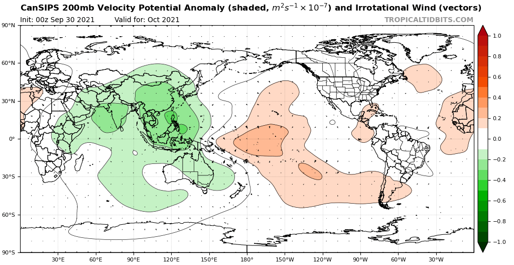
Interestingly the CanSIPS agrees with the CFS and also shows much above normal shear in the Caribbean and Gulf of Mexico. This seems very odd for a -ENSO year.
0 likes
NCSU B.S. in Meteorology Class of 2021. Tropical weather blogger at http://www.cyclonicfury.com. My forecasts and thoughts are NOT official, for official forecasts please consult the National Hurricane Center.
-
AlphaToOmega
- Category 5
- Posts: 1448
- Joined: Sat Jun 26, 2021 10:51 am
- Location: Somewhere in Massachusetts
Re: 2021 Indicators: SST's / SAL / MSLP / Shear / Steering / Instability / Sat Images
CyclonicFury wrote:Interestingly the CanSIPS agrees with the CFS and also shows much above normal shear in the Caribbean and Gulf of Mexico. This seems very odd for a -ENSO year.
https://i.imgur.com/oBZQpbA_d.webp?maxwidth=640&shape=thumb&fidelity=medium
Shear forecasts are typically quite unreliable anyways. I would not give it too much weight.
1 likes

Re: 2021 Indicators: SST's / SAL / MSLP / Shear / Steering / Instability / Sat Images
CyclonicFury wrote:Interestingly the CanSIPS agrees with the CFS and also shows much above normal shear in the Caribbean and Gulf of Mexico. This seems very odd for a -ENSO year.
https://i.imgur.com/oBZQpbA_d.webp?maxwidth=640&shape=thumb&fidelity=medium
IIRC CFS and CanSIPS have been showing above average shear for both September and October since quite some time ago. The September ones generally verified well when you consider monthly averages, but two short periods of low shear (mostly due to intraseasonal factors) allowed Larry, Sam and Victor to form. (While Victor may not get too strong, it's still under a perfect environment now, and what might be seen as struggles today are more due to its own structure rather than shear or dry air.)
This makes me wonder if the above normal shear forecasts for October have the same problem. Maybe monthly averages are skewed by the period of unfavorable CCKW/MJO at the start of October?
5 likes
TC naming lists: retirements and intensity
Most aggressive Advisory #1's in North Atlantic (cr. kevin for starting the list)
Most aggressive Advisory #1's in North Atlantic (cr. kevin for starting the list)
Re: 2021 Indicators: SST's / SAL / MSLP / Shear / Steering / Instability / Sat Images
Hammy wrote::uarrow: The forecast shear amount does appear to have been higher (double, even), but it is still curious as to why that kind of shear is present in a La Nina year in the first place. The modeling did correctly show that the overall atmosphere is not behaving like a typical La Nina, and that it seems the waves are finding pockets that are favorable, allowing them to ramp up quickly, rather than having broader hurricane outbreaks more common seen with a La Nina.
As it looks increasingly unlikely Victor will become a hurricane (and in fact seems it's refusing to intensify at all as of this post), and conditions don't appear to favor a backloaded season like 2016 or 2020, this year's raw numbers are turning out like 2019--massive number of storms but average number of hurricanes, but a few of them broke through the conditions and became fairly intense, and then mostly everything else struggles--very uneven, with far less hurricanes than one would expect for the storm numbers, yet more majors than one would expect given the low percentage that reached hurricane intensity. Both years also saw all of the non-majors being very short-lived at hurricane intensity.
2021 has also been unusual in regard to two things commonly seen in most other active seasons--at no point have two hurricanes been active, and outside of a single advisory as Fred moved inland, there has not at any point been three storms of at least tropical storm intensity active at once, benchmarks I've been using as a comparative reference since 1995.
I'm not sure what the background cause of these sort of seasons is, as they don't seem common, if anybody might have any insight into that. Most other similar types of seasons tended to concentrate activity in the subtropics--1984 and 2002 being examples.
I'm sure this will be taken as a season cancel post, but it's a mere raw observation that something unknown is up with the overall atmosphere that is not typically present in an active season, where several storms that should have had more favorable conditions simply didn't.
One thing I noticed when I was comparing 2020 and 2021 was that the MJO forecasts this year (at least those on Ventrice's site) are much stronger in magnitude than 2020. I wonder if that contributed to what you mentioned, by amplifying the impacts of VP anomalies - making the season go haywire whenever and wherever a favorable CCKW is present, but really die down when a suppressed one enters the basin. This IMO would create pockets of really good conditions instead of the entire basin being slightly favorable for development.
I could be wrong, though.
3 likes
TC naming lists: retirements and intensity
Most aggressive Advisory #1's in North Atlantic (cr. kevin for starting the list)
Most aggressive Advisory #1's in North Atlantic (cr. kevin for starting the list)
-
Category5Kaiju

- Category 5
- Posts: 4335
- Joined: Thu Dec 24, 2020 12:45 pm
- Location: Seattle during the summer, Phoenix during the winter
Re: 2021 Indicators: SST's / SAL / MSLP / Shear / Steering / Instability / Sat Images
Teban54 wrote:Hammy wrote::uarrow: The forecast shear amount does appear to have been higher (double, even), but it is still curious as to why that kind of shear is present in a La Nina year in the first place. The modeling did correctly show that the overall atmosphere is not behaving like a typical La Nina, and that it seems the waves are finding pockets that are favorable, allowing them to ramp up quickly, rather than having broader hurricane outbreaks more common seen with a La Nina.
As it looks increasingly unlikely Victor will become a hurricane (and in fact seems it's refusing to intensify at all as of this post), and conditions don't appear to favor a backloaded season like 2016 or 2020, this year's raw numbers are turning out like 2019--massive number of storms but average number of hurricanes, but a few of them broke through the conditions and became fairly intense, and then mostly everything else struggles--very uneven, with far less hurricanes than one would expect for the storm numbers, yet more majors than one would expect given the low percentage that reached hurricane intensity. Both years also saw all of the non-majors being very short-lived at hurricane intensity.
2021 has also been unusual in regard to two things commonly seen in most other active seasons--at no point have two hurricanes been active, and outside of a single advisory as Fred moved inland, there has not at any point been three storms of at least tropical storm intensity active at once, benchmarks I've been using as a comparative reference since 1995.
I'm not sure what the background cause of these sort of seasons is, as they don't seem common, if anybody might have any insight into that. Most other similar types of seasons tended to concentrate activity in the subtropics--1984 and 2002 being examples.
I'm sure this will be taken as a season cancel post, but it's a mere raw observation that something unknown is up with the overall atmosphere that is not typically present in an active season, where several storms that should have had more favorable conditions simply didn't.
One thing I noticed when I was comparing 2020 and 2021 was that the MJO forecasts this year (at least those on Ventrice's site) are much stronger in magnitude than 2020. I wonder if that contributed to what you mentioned, by amplifying the impacts of VP anomalies - making the season go haywire whenever and wherever a favorable CCKW is present, but really die down when a suppressed one enters the basin. This IMO would create pockets of really good conditions instead of the entire basin being slightly favorable for development.
I could be wrong, though.
You have a very good point, and I am actually inclined to agree that I think the same thing may be the case. This year, starting in August, has really shwon itself to be a slow burn season rather than a fiery burst season. We did not see active, simultaneous hurricanes, but the activity seemed much more spread out to compensate for the lack of multiple hurricanes spinning at once throughout the basin. This is actually cool to see given the recent years that experienced simultaneous hurricanes during peak season; but hey, we are still at 120 ACE and climbing, so there's little doubt that this year is still generally behaving like a solid La Nina year should.
5 likes
Unless explicitly stated, all information in my posts is based on my own opinions and observations. Tropical storms and hurricanes can be extremely dangerous. Refer to an accredited weather research agency or meteorologist if you need to make serious decisions regarding an approaching storm.
-
Deshaunrob17
- Tropical Storm

- Posts: 211
- Joined: Tue Aug 18, 2020 7:49 am
Re: 2021 Indicators: SST's / SAL / MSLP / Shear / Steering / Instability / Sat Images
Category5Kaiju wrote:Teban54 wrote:Hammy wrote::uarrow: The forecast shear amount does appear to have been higher (double, even), but it is still curious as to why that kind of shear is present in a La Nina year in the first place. The modeling did correctly show that the overall atmosphere is not behaving like a typical La Nina, and that it seems the waves are finding pockets that are favorable, allowing them to ramp up quickly, rather than having broader hurricane outbreaks more common seen with a La Nina.
As it looks increasingly unlikely Victor will become a hurricane (and in fact seems it's refusing to intensify at all as of this post), and conditions don't appear to favor a backloaded season like 2016 or 2020, this year's raw numbers are turning out like 2019--massive number of storms but average number of hurricanes, but a few of them broke through the conditions and became fairly intense, and then mostly everything else struggles--very uneven, with far less hurricanes than one would expect for the storm numbers, yet more majors than one would expect given the low percentage that reached hurricane intensity. Both years also saw all of the non-majors being very short-lived at hurricane intensity.
2021 has also been unusual in regard to two things commonly seen in most other active seasons--at no point have two hurricanes been active, and outside of a single advisory as Fred moved inland, there has not at any point been three storms of at least tropical storm intensity active at once, benchmarks I've been using as a comparative reference since 1995.
I'm not sure what the background cause of these sort of seasons is, as they don't seem common, if anybody might have any insight into that. Most other similar types of seasons tended to concentrate activity in the subtropics--1984 and 2002 being examples.
I'm sure this will be taken as a season cancel post, but it's a mere raw observation that something unknown is up with the overall atmosphere that is not typically present in an active season, where several storms that should have had more favorable conditions simply didn't.
One thing I noticed when I was comparing 2020 and 2021 was that the MJO forecasts this year (at least those on Ventrice's site) are much stronger in magnitude than 2020. I wonder if that contributed to what you mentioned, by amplifying the impacts of VP anomalies - making the season go haywire whenever and wherever a favorable CCKW is present, but really die down when a suppressed one enters the basin. This IMO would create pockets of really good conditions instead of the entire basin being slightly favorable for development.
I could be wrong, though.
You have a very good point, and I am actually inclined to agree that I think the same thing may be the case. This year, starting in August, has really shwon itself to be a slow burn season rather than a fiery burst season. We did not see active, simultaneous hurricanes, but the activity seemed much more spread out to compensate for the lack of multiple hurricanes spinning at once throughout the basin. This is actually cool to see given the recent years that experienced simultaneous hurricanes during peak season; but hey, we are still at 120 ACE and climbing, so there's little doubt that this year is still generally behaving like a solid La Nina year should.
This season reminds me of 2011 ,if anything. La Niña like atmosphere, high storm numbers relative to other years, hurricanes were only slightly above average and not much Caribbean activity, as many MDR stuff turned to the North. Although , this is more impressive. Ace is already 120 and it’s only October 1st. I’m impressed with this season still. Coming from 2020 where we saw continuous activity, it makes sense why this year would seem bearish. Every season is active in its own way.
One thing I’ll say that I’m glad didn’t verify is the scary steering patterns that many worried this summer.
If October doesn’t produce significant activity, then this season would definitely remind me of 2019 and 2011
0 likes
-
AlphaToOmega
- Category 5
- Posts: 1448
- Joined: Sat Jun 26, 2021 10:51 am
- Location: Somewhere in Massachusetts
Re: 2021 Indicators: SST's / SAL / MSLP / Shear / Steering / Instability / Sat Images
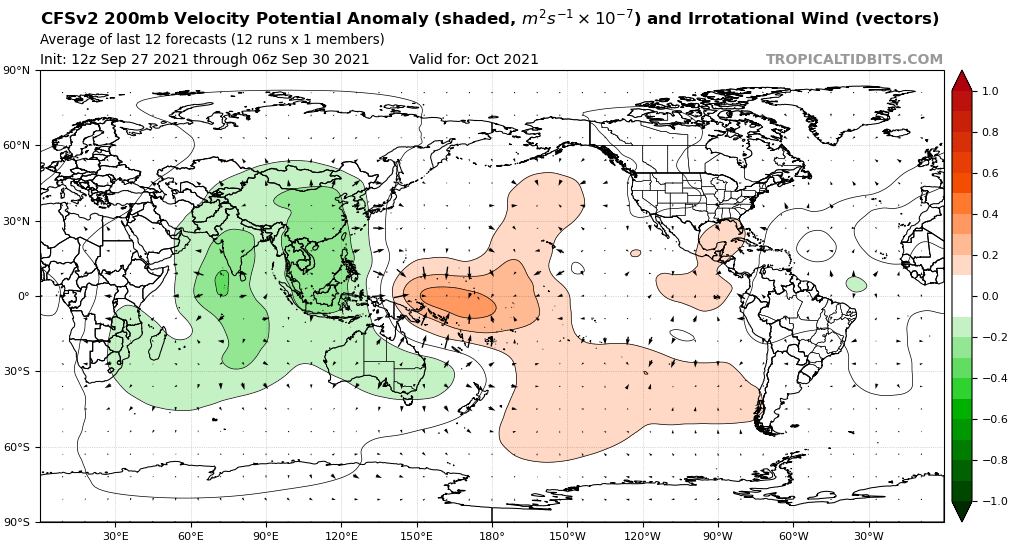
Final VP forecasts for October:
 '
'
'
0 likes

Re: 2021 Indicators: SST's / SAL / MSLP / Shear / Steering / Instability / Sat Images
CyclonicFury wrote:Interestingly the CanSIPS agrees with the CFS and also shows much above normal shear in the Caribbean and Gulf of Mexico. This seems very odd for a -ENSO year.
https://i.imgur.com/oBZQpbA_d.webp?maxwidth=640&shape=thumb&fidelity=medium
It looks like most of the anomalous shear is confined to the next week or two. Upper level winds remain high in the Gulf but the Caribbean and open Atlantic become favorable (<20kt).
3 likes
Kendall -> SLO -> PBC
Memorable Storms: Katrina (for its Florida landfall...) Wilma Matthew Irma
Memorable Storms: Katrina (for its Florida landfall...) Wilma Matthew Irma
-
AlphaToOmega
- Category 5
- Posts: 1448
- Joined: Sat Jun 26, 2021 10:51 am
- Location: Somewhere in Massachusetts
Re: 2021 Indicators: SST's / SAL / MSLP / Shear / Steering / Instability / Sat Images
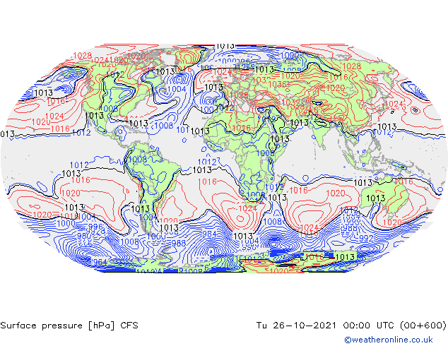
For what it is worth, cast your eyes to the Gulf of Mexico. Still extremely skeptical of model runs 600+ hours out  , but if there is indeed a major hurricane in the Gulf of Mexico during late October, you could thank the CFSv2 for warning you.
0 likes

Re: 2021 Indicators: SST's / SAL / MSLP / Shear / Steering / Instability / Sat Images
AlphaToOmega wrote:For what it is worth, cast your eyes to the Gulf of Mexico. Still extremely skeptical of model runs 600+ hours out
https://i.postimg.cc/BvTczqPH/21102600-0100.gif
Go figure the model starts doing the opposite of what I've been discussing, now that I've been discussing it


Were this model (and the site in general) higher resolution, these would likely both be hurricanes (if not a major in the western Caribbean), though it's inadvisable to focus on the dates shown. I have to wonder now if the model was recalibrating it's focus so to speak, as it had previously been showing an active MDR during October (largely weaker shorter-lived storms)--something that has no longer been the case in recent weeks.
Now to see if this is a trend or not, as I generally check the entire week at once on a weekly basis.
4 likes
The above post is not official and should not be used as such. It is the opinion of the poster and may or may not be backed by sound meteorological data. It is not endorsed by any professional institution or storm2k.org. For official information, please refer to the NHC and NWS products.
Re: 2021 Indicators: SST's / SAL / MSLP / Shear / Steering / Instability / Sat Images
aspen wrote:The suppressive Kelvin Wave might actually increase the risk for something big in the Caribbean, because it’ll give the basin time to recharge and allow waves to sneak further west without developing and recurving. Once the enhanced phase arrives, there will likely be at least one wave in an optimal position to possibly develop.
For sure, I've been stressing this for weeks. Will especially be the case in a year sensitive to intraseasonal variation like 2021. Already some hints at weak Caribbean activity in the ensembles, but velocities will be most favorable mid-late in the month.
2 likes
Kendall -> SLO -> PBC
Memorable Storms: Katrina (for its Florida landfall...) Wilma Matthew Irma
Memorable Storms: Katrina (for its Florida landfall...) Wilma Matthew Irma
-
crownweather

- S2K Supporter

- Posts: 602
- Age: 51
- Joined: Sat Aug 12, 2006 9:21 am
- Location: Sturbridge, Massachusetts
- Contact:
Re: 2021 Indicators: SST's / SAL / MSLP / Shear / Steering / Instability / Sat Images
Hammy wrote:AlphaToOmega wrote:For what it is worth, cast your eyes to the Gulf of Mexico. Still extremely skeptical of model runs 600+ hours out
https://i.postimg.cc/BvTczqPH/21102600-0100.gif
Go figure the model starts doing the opposite of what I've been discussing, now that I've been discussing it
https://i.imgur.com/V27UsPz.png
https://i.imgur.com/rCODgxq.png
Were this model (and the site in general) higher resolution, these would likely both be hurricanes (if not a major in the western Caribbean), though it's inadvisable to focus on the dates shown. I have to wonder now if the model was recalibrating it's focus so to speak, as it had previously been showing an active MDR during October (largely weaker shorter-lived storms)--something that has no longer been the case in recent weeks.
Now to see if this is a trend or not, as I generally check the entire week at once on a weekly basis.
If anyone wants a "different" site for the CFS model, which goes out to 768 hours on their site - give Pivotal Weather a try. https://www.pivotalweather.com/model.php?m=cfs&p=prateptype_cat&fh=loop&r=na&dpdt=&mc=
5 likes
Rob Lightbown
Crown Weather Services
https://crownweather.com
Crown Weather Services
https://crownweather.com

Re: 2021 Indicators: SST's / SAL / MSLP / Shear / Steering / Instability / Sat Images
If there’s one thing September taught us, it’s to not over-estimate the impact of a suppressive Kelvin Wave when a favorable one is moving in, even if it’s not that strong like the one that sparked Sam, Teresa, and Victor. The Kelvin Wave that’ll arrive in the western Atlantic in just over a week will be even stronger and influence a region that is already favored due to a La Niña. We might get very surprised again in 10-15 days.
4 likes
Irene '11 Sandy '12 Hermine '16 5/15/2018 Derecho Fay '20 Isaias '20 Elsa '21 Henri '21 Ida '21
I am only a meteorology enthusiast who knows a decent amount about tropical cyclones. Look to the professional mets, the NHC, or your local weather office for the best information.
I am only a meteorology enthusiast who knows a decent amount about tropical cyclones. Look to the professional mets, the NHC, or your local weather office for the best information.
-
MarioProtVI
- Category 5
- Posts: 1034
- Age: 24
- Joined: Sun Sep 29, 2019 7:33 pm
- Location: New Jersey
Re: 2021 Indicators: SST's / SAL / MSLP / Shear / Steering / Instability / Sat Images
Hammy wrote::uarrow: The forecast shear amount does appear to have been higher (double, even), but it is still curious as to why that kind of shear is present in a La Nina year in the first place. The modeling did correctly show that the overall atmosphere is not behaving like a typical La Nina, and that it seems the waves are finding pockets that are favorable, allowing them to ramp up quickly, rather than having broader hurricane outbreaks more common seen with a La Nina.
As it looks increasingly unlikely Victor will become a hurricane (and in fact seems it's refusing to intensify at all as of this post), and conditions don't appear to favor a backloaded season like 2016 or 2020, this year's raw numbers are turning out like 2019--massive number of storms but average number of hurricanes, but a few of them broke through the conditions and became fairly intense, and then mostly everything else struggles--very uneven, with far less hurricanes than one would expect for the storm numbers, yet more majors than one would expect given the low percentage that reached hurricane intensity. Both years also saw all of the non-majors being very short-lived at hurricane intensity.
2021 has also been unusual in regard to two things commonly seen in most other active seasons--at no point have two hurricanes been active, and outside of a single advisory as Fred moved inland, there has not at any point been three storms of at least tropical storm intensity active at once, benchmarks I've been using as a comparative reference since 1995.
I'm not sure what the background cause of these sort of seasons is, as they don't seem common, if anybody might have any insight into that. Most other similar types of seasons tended to concentrate activity in the subtropics--1984 and 2002 being examples.
I'm sure this will be taken as a season cancel post, but it's a mere raw observation that something unknown is up with the overall atmosphere that is not typically present in an active season, where several storms that should have had more favorable conditions simply didn't.
October can very easily turn things around and produce a few more hurricanes and get us to double digit hurricanes. There’s still time.
3 likes
Re: 2021 Indicators: SST's / SAL / MSLP / Shear / Steering / Instability / Sat Images
aspen wrote:If there’s one thing September taught us, it’s to not over-estimate the impact of a suppressive Kelvin Wave when a favorable one is moving in, even if it’s not that strong like the one that sparked Sam, Teresa, and Victor. The Kelvin Wave that’ll arrive in the western Atlantic in just over a week will be even stronger and influence a region that is already favored due to a La Niña. We might get very surprised again in 10-15 days.
This would coincide with the secondary peak, which is likely even more pronounced during Nina years. Late season last hurrah stateside. Keep an eye on the CPC outlooks over the southeast. If they start leaning warmer and wetter, it's another tailwind favoring late season activity.
0 likes


Re: 2021 Indicators: SST's / SAL / MSLP / Shear / Steering / Instability / Sat Images
IF....and that is a big IF IMO, we see a few more hurricanes during October and November, I think we may make the hyperactive cut after-all. Just did the math and we are at 124.5 units of ACE. That means we need roughly 35 more units to be considered hyperactive. Sam is probably gonna give us another 5 units so that means we will need roughly 30 more units if my math is correct. A hurricane or two that lasts long enough or seeing enough hurricanes form over the next 2 months could easily get us over the wall and onto the hyperactive hurricane season field.
4 likes
-
Category5Kaiju
- Category 5
- Posts: 4335
- Joined: Thu Dec 24, 2020 12:45 pm
- Location: Seattle during the summer, Phoenix during the winter
Re: 2021 Indicators: SST's / SAL / MSLP / Shear / Steering / Instability / Sat Images

Jeez Louise. We definitely do not need or want anything in the West Atlantic anytime soon, especially if there's an anticyclone near or over it; this is just phenomenal, classic late season warmth here.
3 likes
Unless explicitly stated, all information in my posts is based on my own opinions and observations. Tropical storms and hurricanes can be extremely dangerous. Refer to an accredited weather research agency or meteorologist if you need to make serious decisions regarding an approaching storm.
-
AlphaToOmega
- Category 5
- Posts: 1448
- Joined: Sat Jun 26, 2021 10:51 am
- Location: Somewhere in Massachusetts
Re: 2021 Indicators: SST's / SAL / MSLP / Shear / Steering / Instability / Sat Images
Look away if you are in a hurricane-prone area
1 likes
Re: 2021 Indicators: SST's / SAL / MSLP / Shear / Steering / Instability / Sat Images
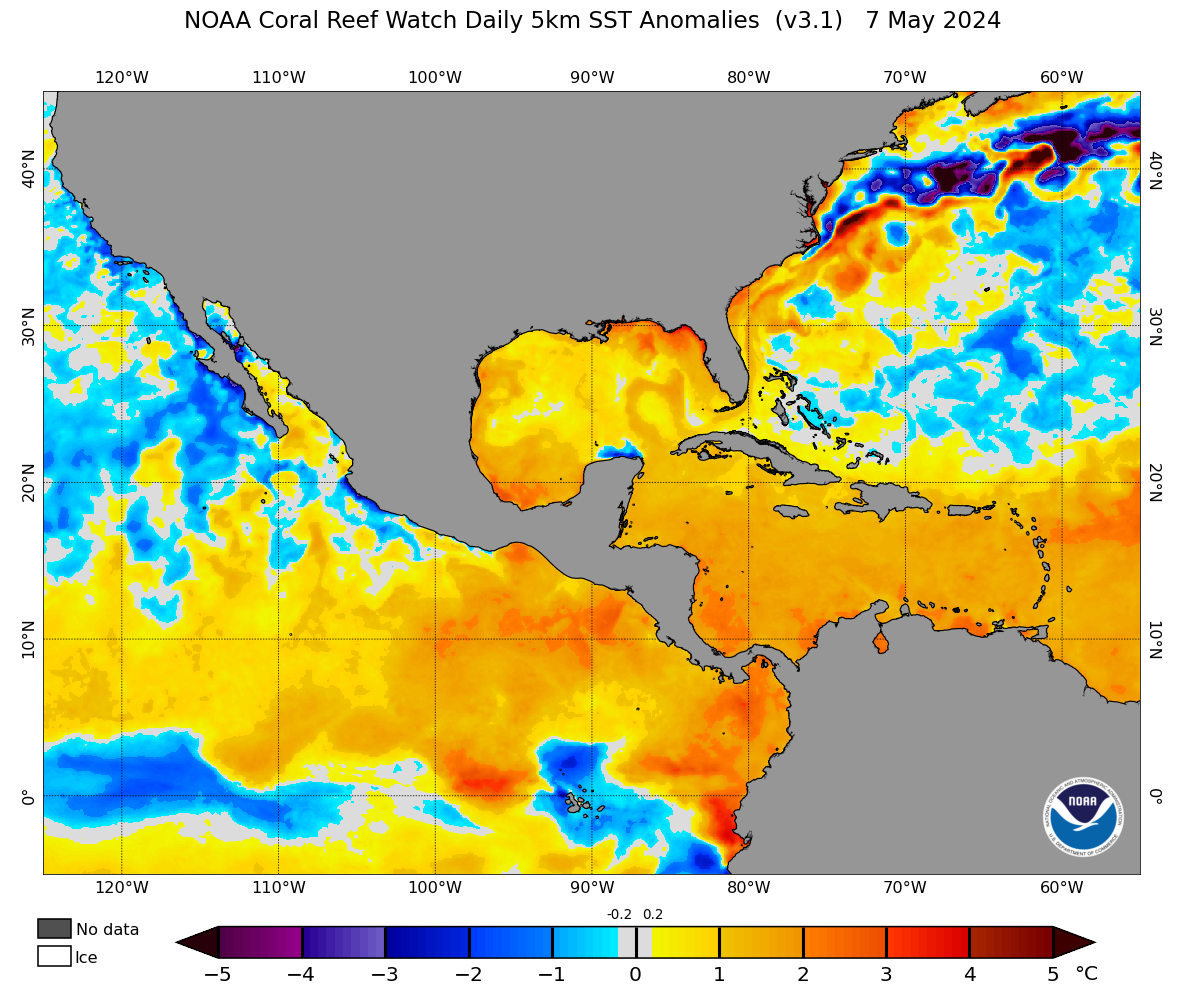
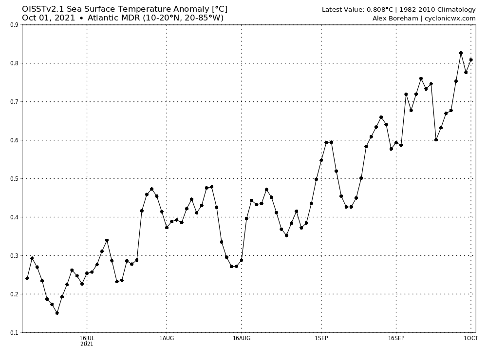
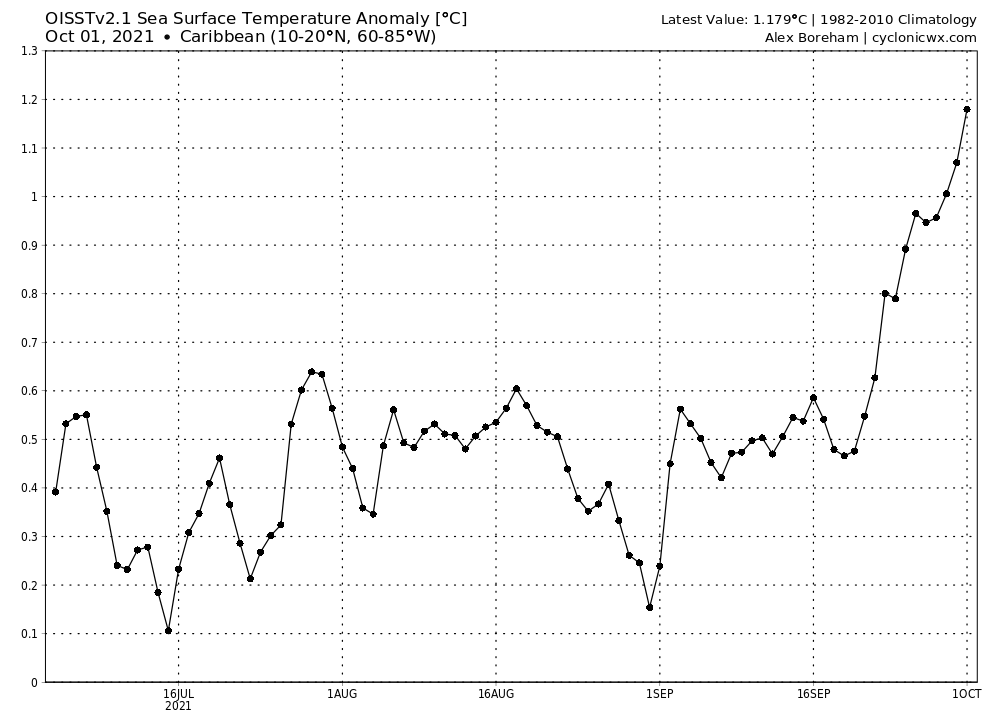
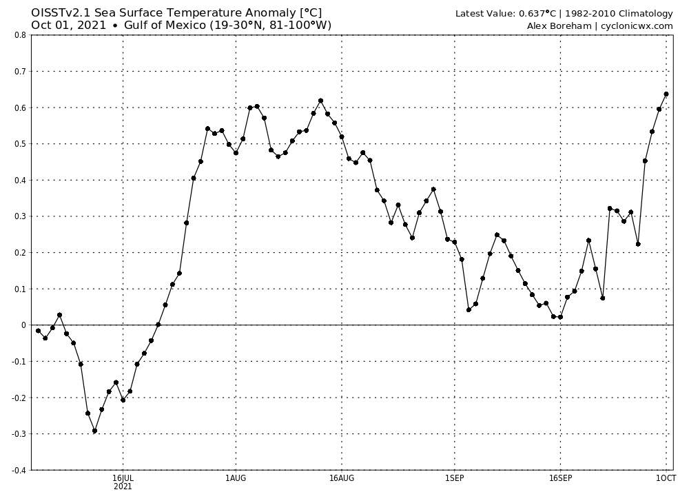
Category5Kaiju wrote:https://coralreefwatch.noaa.gov/data_current/5km/v3.1_op/daily/png/ct5km_ssta_v3.1_nwcl_current.png
https://www.tropicaltidbits.com/analysis/ocean/cdas-sflux_sst_atl_1.png
Jeez Louise. We definitely do not need or want anything in the West Atlantic anytime soon, especially if there's an anticyclone near or over it; this is just phenomenal, classic late season warmth here.
IIRC this is the first time I see 31C SSTs in the Western Caribbean this season. Previously, 31C SSTs have been mostly confined to the Bahamas region or occasionally Eastern Caribbean.
Not good if a storm takes the standard October track across Cuba under ideal conditions, as many Octobers featured such a storm that RI'ed right up to Cuba landfall. One of those peaked at 135 kts IIRC. Even worse if it goes on to impact Florida afterwards.
0 likes
TC naming lists: retirements and intensity
Most aggressive Advisory #1's in North Atlantic (cr. kevin for starting the list)
Most aggressive Advisory #1's in North Atlantic (cr. kevin for starting the list)
Re: 2021 Indicators: SST's / SAL / MSLP / Shear / Steering / Instability / Sat Images
I'm not sure how this may play into tropical activity in the first half of Oct, but this is about as warm as it has ever been for the eastern 3/4 of the CONUS overall (though not for FL and the SE US specifically) in the first half of October. Any feelings on the implications?

0 likes
Personal Forecast Disclaimer:
The posts in this forum are NOT official forecasts and should not be used as such. They are just the opinion of the poster and may or may not be backed by sound meteorological data. They are NOT endorsed by any professional institution or storm2k.org. For official information, please refer to the NHC and NWS products.
The posts in this forum are NOT official forecasts and should not be used as such. They are just the opinion of the poster and may or may not be backed by sound meteorological data. They are NOT endorsed by any professional institution or storm2k.org. For official information, please refer to the NHC and NWS products.
Who is online
Users browsing this forum: chaser1 and 211 guests