2021 Indicators: SST's / SAL / MSLP / Shear / Steering / Instability / Sat Images

This is the general tropical discussion area. Anyone can take their shot at predicting a storms path.

Moderator: S2k Moderators

Forum rules

The posts in this forum are NOT official forecasts and should not be used as such. They are just the opinion of the poster and may or may not be backed by sound meteorological data. They are NOT endorsed by any professional institution or STORM2K. For official information, please refer to products from the National Hurricane Center and National Weather Service.

Help Support Storm2K
Message
Author
AlphaToOmega
Category 5
Category 5
Posts: 1448
Joined: Sat Jun 26, 2021 10:51 am
Location: Somewhere in Massachusetts

Re: 2021 Indicators: SST's / SAL / MSLP / Shear / Steering / Instability / Sat Images

#3721 Postby AlphaToOmega » Fri Oct 01, 2021 3:08 pm

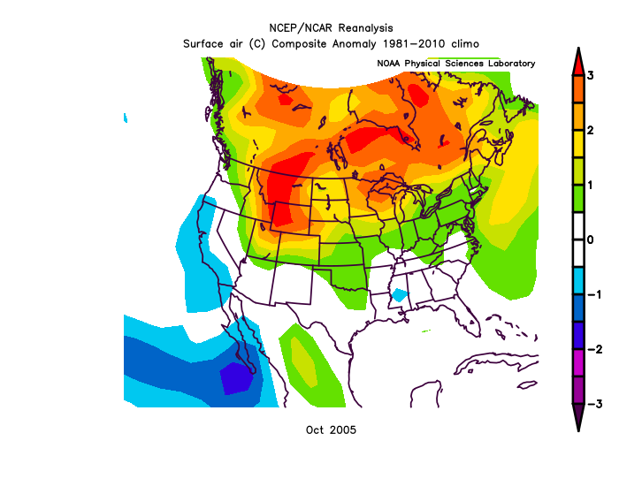
LarryWx wrote:I'm not sure how this may play into tropical activity in the first half of Oct, but this is about as warm as it has ever been for the eastern 3/4 of the CONUS overall (though not for FL and the SE US specifically) in the first half of October. Any feelings on the implications?

https://i.imgur.com/DqFDiSC.png


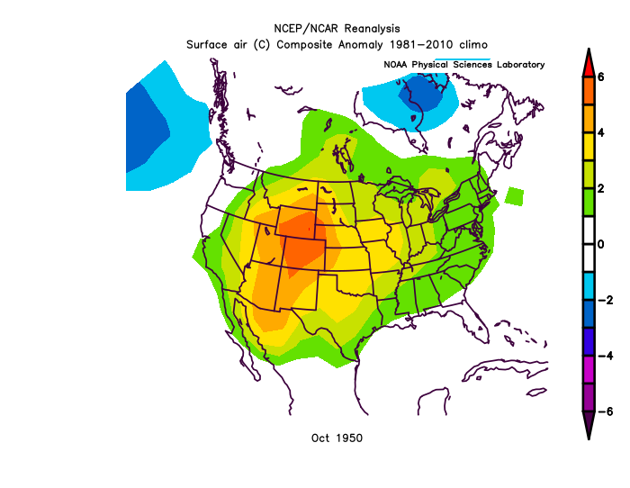
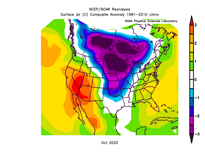
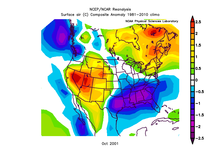
Other seasons with active Octobers:
Image
Image
Image
Image

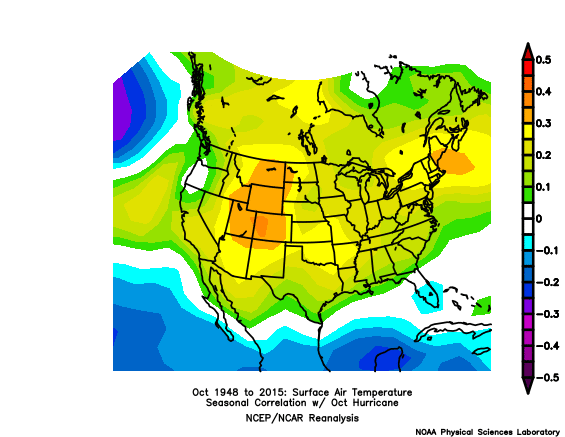
Patters are all over the place. However, there is weak correlation between October activity and CONUS temperatures.
Image

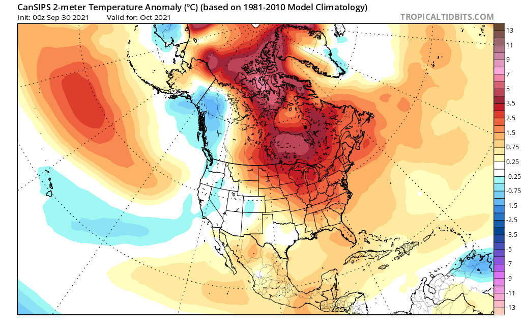
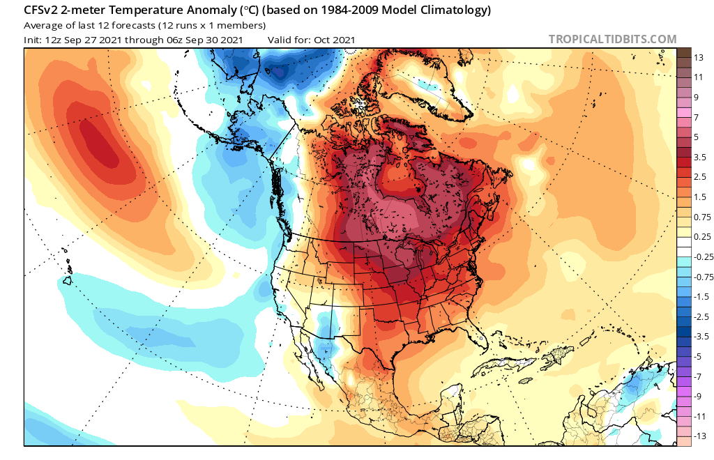
The CFSv2 and CanSIPS show somewhat similar patterns. However, I would not use this to support an active or inactive October.
Image
Image
4 likes   

User avatar
Category5Kaiju
Category 5
Category 5
Posts: 4095
Joined: Thu Dec 24, 2020 12:45 pm
Location: Seattle

Re: 2021 Indicators: SST's / SAL / MSLP / Shear / Steering / Instability / Sat Images

#3722 Postby Category5Kaiju » Fri Oct 01, 2021 3:08 pm

In case we do get a late season major somewhere in the basin, does anybody know if SailDrone will dispatch a drone into the storm's eye? They got some wicked good footage in Sam, so I am wondering if they'll be doing it again this season
1 likes   
Unless explicitly stated, all info in my posts is based on my own opinions and observations. Tropical storms and hurricanes can be extremely dangerous. Do not think you can beat Mother Nature. Refer to an accredited weather research agency or meteorologist if you need to make serious decisions regarding an approaching storm.

User avatar
gatorcane
S2K Supporter
S2K Supporter
Posts: 23691
Age: 47
Joined: Sun Mar 13, 2005 3:54 pm
Location: Boca Raton, FL

Re: 2021 Indicators: SST's / SAL / MSLP / Shear / Steering / Instability / Sat Images

#3723 Postby gatorcane » Fri Oct 01, 2021 3:36 pm

AlphaToOmega wrote:
LarryWx wrote:I'm not sure how this may play into tropical activity in the first half of Oct, but this is about as warm as it has ever been for the eastern 3/4 of the CONUS overall (though not for FL and the SE US specifically) in the first half of October. Any feelings on the implications?

https://i.imgur.com/DqFDiSC.png


Other seasons with active Octobers:
https://i.postimg.cc/fWBzfgZB/0-Twbb-E-ni8.png
https://i.postimg.cc/3Jq3P4kG/9-Xf-Fy6-Nx-Pg.png
https://i.postimg.cc/j2gRqCvG/Rq-Upnr9ll-O.png
https://i.postimg.cc/QxCX4kds/u-KB4mdtpy-G.png

Patters are all over the place. However, there is weak correlation between October activity and CONUS temperatures.
https://i.postimg.cc/v89jQ429/24-218-246-161-273-13-48-2.gif

The CFSv2 and CanSIPS show somewhat similar patterns. However, I would not use this to support an active or inactive October.
https://i.postimg.cc/MGCD4DSL/cansips-T2ma-namer-1.png
https://i.postimg.cc/hG6ynn9p/cfs-mon-01-T2ma-namer-1.png


Here in Florida, the rainy season seems to have shut down a few weeks earlier than it is usually does. Not sure if that is an indicator or not as far as the season shutting down early for Florida (it also started later than it usually does with sub 70 dew points into June). With a La Niña and above normal SSTs across the Caribbean, one would think a big storm could develop there though this month. Until a meaningful push of cooler air moves into Florida which doesn’t look like it will happen for a while, the Caribbean will bear watching for possible Florida threat.
1 likes   

AlphaToOmega
Category 5
Category 5
Posts: 1448
Joined: Sat Jun 26, 2021 10:51 am
Location: Somewhere in Massachusetts

Re: 2021 Indicators: SST's / SAL / MSLP / Shear / Steering / Instability / Sat Images

#3724 Postby AlphaToOmega » Fri Oct 01, 2021 3:41 pm

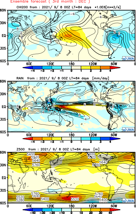
The JMA shows rising air over the Atlantic, Africa, and the Indian Ocean; and sinking air over the Pacific. Could this mean that activity could continue into December?
Image
0 likes   

User avatar
Category5Kaiju
Category 5
Category 5
Posts: 4095
Joined: Thu Dec 24, 2020 12:45 pm
Location: Seattle

Re: 2021 Indicators: SST's / SAL / MSLP / Shear / Steering / Instability / Sat Images

#3725 Postby Category5Kaiju » Fri Oct 01, 2021 3:47 pm

AlphaToOmega wrote:The JMA shows rising air over the Atlantic, Africa, and the Indian Ocean; and sinking air over the Pacific. Could this mean that activity could continue into December?
https://i.postimg.cc/8CF5c2Y7/Y202109-D0800-gl0.png


December activity is extremely hard to predict months in advance; it is almost as if it is random to a certain extent. Years like 2005, 2003, 2013, and 1975 had storms form in December; those years had very little in common with each other. We'll see what happens, but given December is usually a shear-rampant month throughout the basin, December NS formation is not guaranteed in any given year
0 likes   
Unless explicitly stated, all info in my posts is based on my own opinions and observations. Tropical storms and hurricanes can be extremely dangerous. Do not think you can beat Mother Nature. Refer to an accredited weather research agency or meteorologist if you need to make serious decisions regarding an approaching storm.

User avatar
gatorcane
S2K Supporter
S2K Supporter
Posts: 23691
Age: 47
Joined: Sun Mar 13, 2005 3:54 pm
Location: Boca Raton, FL

Re: 2021 Indicators: SST's / SAL / MSLP / Shear / Steering / Instability / Sat Images

#3726 Postby gatorcane » Fri Oct 01, 2021 3:51 pm

Category5Kaiju wrote:
AlphaToOmega wrote:The JMA shows rising air over the Atlantic, Africa, and the Indian Ocean; and sinking air over the Pacific. Could this mean that activity could continue into December?
https://i.postimg.cc/8CF5c2Y7/Y202109-D0800-gl0.png


December activity is extremely hard to predict months in advance; it is almost as if it is random to a certain extent. Years like 2005, 2003, 2013, and 1975 had storms form in December; those years had very little in common with each other. We'll see what happens, but given December is usually a shear-rampant month throughout the basin, December NS formation is not guaranteed in any given year


I would say doubtful for December but November activity particularly the Caribbean is certainly possible.
0 likes   

User avatar
abajan
S2K Supporter
S2K Supporter
Posts: 4230
Joined: Sun Sep 07, 2003 5:10 am
Location: Barbados

Re: 2021 Indicators: SST's / SAL / MSLP / Shear / Steering / Instability / Sat Images

#3727 Postby abajan » Fri Oct 01, 2021 4:28 pm

Mark mentions this thread, and a couple of its specific posts. :lol:

[youtube]https://youtu.be/1IJS6S02cPk[/youtube]
2 likes   

User avatar
Hammy
Category 5
Category 5
Posts: 5849
Age: 41
Joined: Fri May 25, 2012 5:25 pm
Contact:

Re: 2021 Indicators: SST's / SAL / MSLP / Shear / Steering / Instability / Sat Images

#3728 Postby Hammy » Fri Oct 01, 2021 4:52 pm

crownweather wrote:
Hammy wrote:
AlphaToOmega wrote:For what it is worth, cast your eyes to the Gulf of Mexico. Still extremely skeptical of model runs 600+ hours out :D, but if there is indeed a major hurricane in the Gulf of Mexico during late October, you could thank the CFSv2 for warning you.

https://i.postimg.cc/BvTczqPH/21102600-0100.gif


Go figure the model starts doing the opposite of what I've been discussing, now that I've been discussing it :lol:

https://i.imgur.com/V27UsPz.png
https://i.imgur.com/rCODgxq.png

Were this model (and the site in general) higher resolution, these would likely both be hurricanes (if not a major in the western Caribbean), though it's inadvisable to focus on the dates shown. I have to wonder now if the model was recalibrating it's focus so to speak, as it had previously been showing an active MDR during October (largely weaker shorter-lived storms)--something that has no longer been the case in recent weeks.

Now to see if this is a trend or not, as I generally check the entire week at once on a weekly basis.


If anyone wants a "different" site for the CFS model, which goes out to 768 hours on their site - give Pivotal Weather a try. https://www.pivotalweather.com/model.php?m=cfs&p=prateptype_cat&fh=loop&r=na&dpdt=&mc=


Much better site, but also demonstrates how poor the resolution is (presumably the case with any climate model) with Sam initializing at 997mb.
2 likes   
The above post is not official and should not be used as such. It is the opinion of the poster and may or may not be backed by sound meteorological data. It is not endorsed by any professional institution or storm2k.org. For official information, please refer to the NHC and NWS products.

User avatar
WiscoWx02
Category 1
Category 1
Posts: 391
Joined: Sat Jul 31, 2021 8:09 pm

Re: 2021 Indicators: SST's / SAL / MSLP / Shear / Steering / Instability / Sat Images

#3729 Postby WiscoWx02 » Fri Oct 01, 2021 5:23 pm

Hammy wrote:
crownweather wrote:
Hammy wrote:
Go figure the model starts doing the opposite of what I've been discussing, now that I've been discussing it :lol:

https://i.imgur.com/V27UsPz.png
https://i.imgur.com/rCODgxq.png

Were this model (and the site in general) higher resolution, these would likely both be hurricanes (if not a major in the western Caribbean), though it's inadvisable to focus on the dates shown. I have to wonder now if the model was recalibrating it's focus so to speak, as it had previously been showing an active MDR during October (largely weaker shorter-lived storms)--something that has no longer been the case in recent weeks.

Now to see if this is a trend or not, as I generally check the entire week at once on a weekly basis.


If anyone wants a "different" site for the CFS model, which goes out to 768 hours on their site - give Pivotal Weather a try. https://www.pivotalweather.com/model.php?m=cfs&p=prateptype_cat&fh=loop&r=na&dpdt=&mc=


Much better site, but also demonstrates how poor the resolution is (presumably the case with any climate model) with Sam initializing at 997mb.


Very true. As Mark said in his daily video update, it's a very fuzzy look ahead. I mean, there are definitely a few areas of interest there that catch my attention. Guess that's enough to be concerned about especially if it shows a near cat 5 hurricane only being a moderate strength tropical storm at initialization.
1 likes   

AlphaToOmega
Category 5
Category 5
Posts: 1448
Joined: Sat Jun 26, 2021 10:51 am
Location: Somewhere in Massachusetts

Re: 2021 Indicators: SST's / SAL / MSLP / Shear / Steering / Instability / Sat Images

#3730 Postby AlphaToOmega » Fri Oct 01, 2021 5:25 pm

Retrospective of September 2021:

9 storms, 3 hurricanes, and 2 major hurricanes formed. The month featured a high quantity of storms, and it featured many quality storms, namely Larry and Sam. Moreover, it helped 2021 exceed the above-average ACE threshold of 126.1. Typically the average hurricane season features 8 storms, 4 hurricanes, and 1 major hurricane by September 30. As of now, this hurricane season is featuring tropical cyclogenesis at twice the climatologically average rate; ACE is also 50% of the mean by September 30.

Because of near-record-breaking SSTs in the MDR, an impending La Niña, a cooler-than-average PDO, and a generally warm Atlantic, the background state was favorable for September 2021. Plus, velocity potential patterns were favorable this month, featuring rising air in the Afro-Eurasia and sinking air in the Pacific Ocean and the Americas. Despite a theoretically unfavorable MJO phase, the African Standing Wave kept the North Atlantic active through the month of September.

Despite the high amount of activity, there were no major impacts from any hurricanes during the month of September. Unlike August 2021, which featured both major hurricanes forming in the Western Atlantic, September 2021 featured both major hurricanes forming in the MDR near Cape Verde.
2 likes   
storminabox
Category 1
Category 1
Posts: 263
Joined: Sun Jul 09, 2017 10:50 pm

Re: 2021 Indicators: SST's / SAL / MSLP / Shear / Steering / Instability / Sat Images

#3731 Postby storminabox » Fri Oct 01, 2021 5:28 pm

gatorcane wrote:
AlphaToOmega wrote:
LarryWx wrote:I'm not sure how this may play into tropical activity in the first half of Oct, but this is about as warm as it has ever been for the eastern 3/4 of the CONUS overall (though not for FL and the SE US specifically) in the first half of October. Any feelings on the implications?

https://i.imgur.com/DqFDiSC.png


Other seasons with active Octobers:
https://i.postimg.cc/fWBzfgZB/0-Twbb-E-ni8.png
https://i.postimg.cc/3Jq3P4kG/9-Xf-Fy6-Nx-Pg.png
https://i.postimg.cc/j2gRqCvG/Rq-Upnr9ll-O.png
https://i.postimg.cc/QxCX4kds/u-KB4mdtpy-G.png

Patters are all over the place. However, there is weak correlation between October activity and CONUS temperatures.
https://i.postimg.cc/v89jQ429/24-218-246-161-273-13-48-2.gif

The CFSv2 and CanSIPS show somewhat similar patterns. However, I would not use this to support an active or inactive October.
https://i.postimg.cc/MGCD4DSL/cansips-T2ma-namer-1.png
https://i.postimg.cc/hG6ynn9p/cfs-mon-01-T2ma-namer-1.png


Here in Florida, the rainy season seems to have shut down a few weeks earlier than it is usually does. Not sure if that is an indicator or not as far as the season shutting down early for Florida (it also started later than it usually does with sub 70 dew points into June). With a La Niña and above normal SSTs across the Caribbean, one would think a big storm could develop there though this month. Until a meaningful push of cooler air moves into Florida which doesn’t look like it will happen for a while, the Caribbean will bear watching for possible Florida threat.


Wouldn’t say that yet. Got some very heavy thunderstorms in S Fl today. Don’t think it’ll end until we get a really solid cold front to move in here.
0 likes   

tolakram
Admin
Admin
Posts: 20009
Age: 62
Joined: Sun Aug 27, 2006 8:23 pm
Location: Florence, KY (name is Mark)

Re: 2021 Indicators: SST's / SAL / MSLP / Shear / Steering / Instability / Sat Images

#3732 Postby tolakram » Fri Oct 01, 2021 6:46 pm

abajan wrote:Mark mentions this thread, and a couple of its specific posts. :lol:

https://youtu.be/1IJS6S02cPk


Yay, Hammy and the CFS got mentioned. :D
8 likes   
M a r k
- - - - -
Join us in chat: Storm2K Chatroom Invite. Android and IOS apps also available.

The posts in this forum are NOT official forecasts and should not be used as such. Posts are NOT endorsed by any professional institution or STORM2K.org. For official information and forecasts, please refer to NHC and NWS products.

User avatar
Ubuntwo
Category 5
Category 5
Posts: 1406
Age: 31
Joined: Thu Oct 05, 2017 10:41 pm

Re: 2021 Indicators: SST's / SAL / MSLP / Shear / Steering / Instability / Sat Images

#3733 Postby Ubuntwo » Fri Oct 01, 2021 8:42 pm

Hazelton is thinking development a little later
 https://twitter.com/AndyHazelton/status/1444097408401616899


1 likes   
Kendall -> SLO -> PBC

Memorable Storms: Katrina (for its Florida landfall...) Wilma Matthew Irma

User avatar
WiscoWx02
Category 1
Category 1
Posts: 391
Joined: Sat Jul 31, 2021 8:09 pm

Re: 2021 Indicators: SST's / SAL / MSLP / Shear / Steering / Instability / Sat Images

#3734 Postby WiscoWx02 » Fri Oct 01, 2021 10:06 pm

Ubuntwo wrote:Hazelton is thinking development a little later
https://twitter.com/AndyHazelton/status/1444097408401616899


This seems far more realistic. Coincides with that second peak regarding climatology as well as when the MJO rolls in. Joe Bastardi sure as heck thinks big things are coming. Can't lie, those JMA predictions are a bit ominous :eek:

 https://twitter.com/BigJoeBastardi/status/1443623528893501441


0 likes   

User avatar
chaser1
S2K Supporter
S2K Supporter
Posts: 5464
Age: 64
Joined: Sat Oct 15, 2005 5:59 pm
Location: Longwood, Fl

Re: 2021 Indicators: SST's / SAL / MSLP / Shear / Steering / Instability / Sat Images

#3735 Postby chaser1 » Sat Oct 02, 2021 1:38 am

WiscoWx02 wrote:
Ubuntwo wrote:Hazelton is thinking development a little later
https://twitter.com/AndyHazelton/status/1444097408401616899


This seems far more realistic. Coincides with that second peak regarding climatology as well as when the MJO rolls in. Joe Bastardi sure as heck thinks big things are coming. Can't lie, those JMA predictions are a bit ominous :eek:

https://twitter.com/BigJoeBastardi/status/1443623528893501441/photo/1


It goes against my grain but I'm gonna have to give a fist-bump to Joe on this one
2 likes   
Andy D

(For official information, please refer to the NHC and NWS products.)

AlphaToOmega
Category 5
Category 5
Posts: 1448
Joined: Sat Jun 26, 2021 10:51 am
Location: Somewhere in Massachusetts

Re: 2021 Indicators: SST's / SAL / MSLP / Shear / Steering / Instability / Sat Images

#3736 Postby AlphaToOmega » Sat Oct 02, 2021 4:48 am

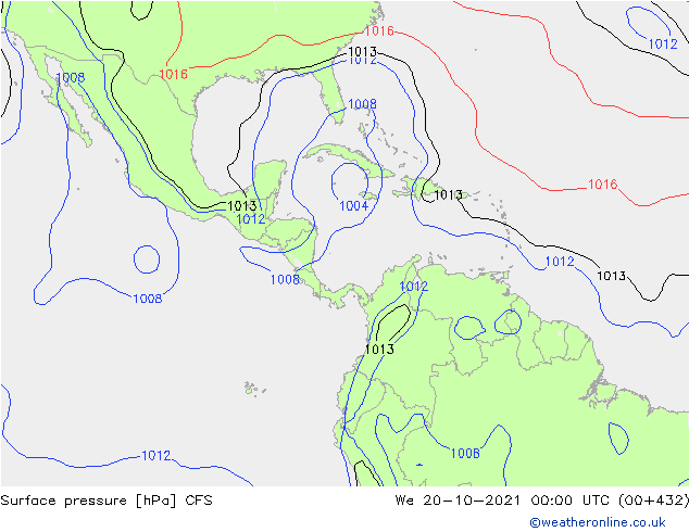
For whatever this could possibly be worth, the CFSv2 continues to show the signal of a major hurricane in late October. On this run, the date is shifted from October 26 to October 20. However, we should take 400+ hour runs with mountains of salt.
Image
3 likes   

User avatar
Category5Kaiju
Category 5
Category 5
Posts: 4095
Joined: Thu Dec 24, 2020 12:45 pm
Location: Seattle

Re: 2021 Indicators: SST's / SAL / MSLP / Shear / Steering / Instability / Sat Images

#3737 Postby Category5Kaiju » Sat Oct 02, 2021 7:38 am

Image

:sadly:
6 likes   
Unless explicitly stated, all info in my posts is based on my own opinions and observations. Tropical storms and hurricanes can be extremely dangerous. Do not think you can beat Mother Nature. Refer to an accredited weather research agency or meteorologist if you need to make serious decisions regarding an approaching storm.

Shell Mound
Category 5
Category 5
Posts: 2434
Age: 32
Joined: Thu Sep 07, 2017 3:39 pm
Location: St. Petersburg, FL → Scandinavia

Re: 2021 Indicators: SST's / SAL / MSLP / Shear / Steering / Instability / Sat Images

#3738 Postby Shell Mound » Sat Oct 02, 2021 9:24 am

I think we will likely see at least one more major hurricane, but not before the second half of October. As most of its October impacts occur early in the month, peninsular Florida may well escape additional threats. Nevertheless, I am concerned about a 1932-, Michelle-, or Paloma-type major that develops over the Western Caribbean in late October or early November and misses FL but impacts the Cayman Islands, Cuba, and the Bahamas before heading OTS. I just don't foresee a Wilma- or Michael-type threat to FL this year, but we shall see.
1 likes   
CVW / MiamiensisWx / Shell Mound
The posts in this forum are NOT official forecasts and should not be used as such. They are just the opinion of the poster and may or may not be backed by sound meteorological data. They are NOT endorsed by any professional institution or STORM2K. For official information, please refer to products from the NHC and NWS.

User avatar
Teban54
Category 5
Category 5
Posts: 3204
Joined: Sat May 19, 2018 1:19 pm

Re: 2021 Indicators: SST's / SAL / MSLP / Shear / Steering / Instability / Sat Images

#3739 Postby Teban54 » Sat Oct 02, 2021 10:43 am

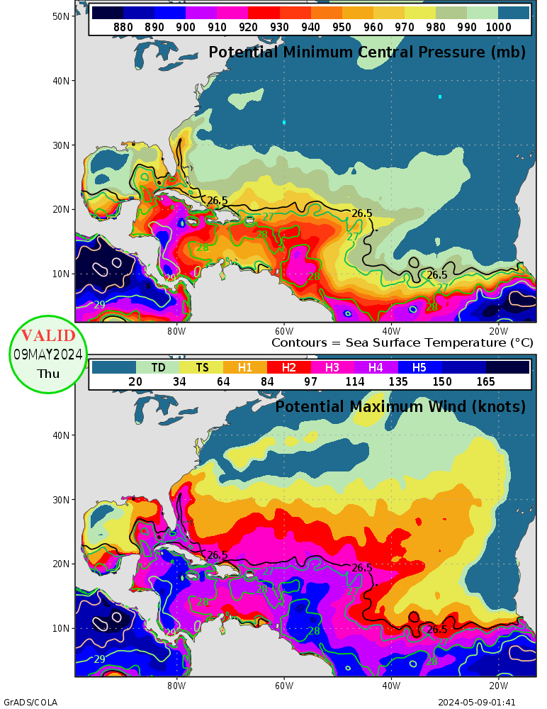
Category5Kaiju wrote:http://wxmaps.org/pix/atlpot.png

:sadly:

Imagine if we actually get a sub-900 mb storm.
0 likes   

User avatar
Category5Kaiju
Category 5
Category 5
Posts: 4095
Joined: Thu Dec 24, 2020 12:45 pm
Location: Seattle

Re: 2021 Indicators: SST's / SAL / MSLP / Shear / Steering / Instability / Sat Images

#3740 Postby Category5Kaiju » Sat Oct 02, 2021 10:47 am

Teban54 wrote:
Category5Kaiju wrote:http://wxmaps.org/pix/atlpot.png

:sadly:

Imagine if we actually get a sub-900 mb storm.


It's been 16 years since that last happened, and given how we have only had 5 recorded Atlantic hurricane years with a 900 mbar or lower storm (1935, 1969, 1980, 1988, and 2005), this just shows you a testament of how extraordinarily hard and rare it is to get one in a given year. Not really banking on it happening again this year just because of how rare it is and the near-perfect conditions needed to exist at the right time and place to get a sub-900 storm, although if you ask me, a very powerful October hurricane in the West Atlantic may still be in the cards.
Last edited by Category5Kaiju on Sat Oct 02, 2021 10:47 am, edited 1 time in total.
0 likes   
Unless explicitly stated, all info in my posts is based on my own opinions and observations. Tropical storms and hurricanes can be extremely dangerous. Do not think you can beat Mother Nature. Refer to an accredited weather research agency or meteorologist if you need to make serious decisions regarding an approaching storm.


Return to “Talkin' Tropics”

Who is online

Users browsing this forum: HurricaneBelle, KeysRedWine, Stormybajan and 27 guests