There has been significant warming at a faster than normal pace in the tropical Atlantic during the past 7 days
https://www.tropicaltidbits.com/analysi ... _atl_1.png
2018 Indicators: SST's / MSLP / Sal / Steering / Shear / Instability (Graphic updates at first post)
Moderator: S2k Moderators
Forum rules

The posts in this forum are NOT official forecasts and should not be used as such. They are just the opinion of the poster and may or may not be backed by sound meteorological data. They are NOT endorsed by any professional institution or STORM2K. For official information, please refer to products from the National Hurricane Center and National Weather Service.
-
Dougiefresh
- Tropical Depression

- Posts: 55
- Age: 36
- Joined: Thu Jun 08, 2017 8:07 am
- Location: Barbados
Re: 2018 Indicators: SST's / MSLP / Sal / Steering / Shear / Instability (Graphic updates at first post)
chaser1 wrote::uarrow: WOWThose of you kiddies there in the Islands, don't forget to leave your beach pails and shovels outside when you go to bed at night. In the morning, you might be rewarded with your pail suddenly half full with sand!
Got that right, everyone's car in Barbados right now looks like we all went off roading.
0 likes
-
NotSparta

- Professional-Met

- Posts: 1677
- Age: 24
- Joined: Fri Aug 18, 2017 8:24 am
- Location: Naples, FL
- Contact:
Re: 2018 Indicators: SST's / MSLP / Sal / Steering / Shear / Instability (Graphic updates at first post)
GFS and EURO hinting at weaker than normal trades due to subtropical ridge anomalously far north, displacing enhanced easterlies to the north:


1 likes
This post was probably an opinion of mine, and in no way is official. Please refer to http://www.hurricanes.gov for official tropical analysis and advisories.
My website, with lots of tropical wx graphics, including satellite and recon: http://cyclonicwx.com
My website, with lots of tropical wx graphics, including satellite and recon: http://cyclonicwx.com
-
CyclonicFury

- Category 5

- Posts: 2038
- Age: 27
- Joined: Sun Jul 02, 2017 12:32 pm
- Location: NC
- Contact:
Re: 2018 Indicators: SST's / MSLP / Sal / Steering / Shear / Instability (Graphic updates at first post)
Will be interesting to see how much the MDR warms compared to normal over the next few weeks. Maybe it could get to average by peak season if slow trades continue over the coming months.
3 likes
NCSU B.S. in Meteorology Class of 2021. Tropical weather blogger at http://www.cyclonicfury.com. My forecasts and thoughts are NOT official, for official forecasts please consult the National Hurricane Center.
-
NotSparta
- Professional-Met
- Posts: 1677
- Age: 24
- Joined: Fri Aug 18, 2017 8:24 am
- Location: Naples, FL
- Contact:
Re: 2018 Indicators: SST's / MSLP / Sal / Steering / Shear / Instability (Graphic updates at first post)
CyclonicFury wrote::uarrow:
Will be interesting to see how much the MDR warms compared to normal over the next few weeks. Maybe it could get to average by peak season if slow trades continue over the coming months.
For a long time, it has been quite difficult to get a -NAO going. the only one of significance this year was caused by the SSW. imo, the only way this is possible is if the high does end up being displaced north like this frequently.
2 likes
This post was probably an opinion of mine, and in no way is official. Please refer to http://www.hurricanes.gov for official tropical analysis and advisories.
My website, with lots of tropical wx graphics, including satellite and recon: http://cyclonicwx.com
My website, with lots of tropical wx graphics, including satellite and recon: http://cyclonicwx.com
-
cycloneye

- Admin

- Posts: 149721
- Age: 69
- Joined: Thu Oct 10, 2002 10:54 am
- Location: San Juan, Puerto Rico
Re: 2018 Indicators: SST's / MSLP / Sal / Steering / Shear / Instability (Graphic updates at first post)
@ToddKimberlain
The TUTT or Tropical Upper Tropospheric Trough has developed unusually early this year and has been strong, both typical characteristics of an inactive #HurricaneSeason. Its persistence would mean greatly reduced activity at low latitudes #tropics
https://twitter.com/ToddKimberlain/status/1006957374601605120
3 likes
Visit the Caribbean-Central America Weather Thread where you can find at first post web cams,radars
and observations from Caribbean basin members Click Here
and observations from Caribbean basin members Click Here

Re: 2018 Indicators: SST's / MSLP / Sal / Steering / Shear / Instability (Graphic updates at first post)
Current Saharan dust coming across the Caribbean will be reaching the gulf coast by the weekend into early next week 


1 likes
-
gatorcane

- S2K Supporter

- Posts: 23708
- Age: 48
- Joined: Sun Mar 13, 2005 3:54 pm
- Location: Boca Raton, FL
Re: 2018 Indicators: SST's / MSLP / Sal / Steering / Shear / Instability (Graphic updates at first post)
NDG wrote:Current Saharan dust coming across the Caribbean will be reaching the gulf coast by the weekend into early next week
https://i.imgur.com/GBzBUFc.png
https://i.imgur.com/PmvfA5b.png
Yeah pretty impressive but not sure what kind of indicator this may be as it is always dusty out there from around now until middle August
1 likes


Re: 2018 Indicators: SST's / MSLP / Sal / Steering / Shear / Instability (Graphic updates at first post)
Speaking of Africa, Northern Africa has been anomalously wet so far this year. Let's see how it evolves as the season goes on.

3 likes

Re: 2018 Indicators: SST's / MSLP / Sal / Steering / Shear / Instability (Graphic updates at first post)
Siker wrote:Speaking of Africa, Northern Africa has been anomalously wet so far this year. Let's see how it evolves as the season goes on.
Yes this is interesting. Just tonight I checked the SAL loop and it is not as intense as I normally remember it being for this month last year.
1 likes
-
gatorcane
- S2K Supporter
- Posts: 23708
- Age: 48
- Joined: Sun Mar 13, 2005 3:54 pm
- Location: Boca Raton, FL
Re: 2018 Indicators: SST's / MSLP / Sal / Steering / Shear / Instability (Graphic updates at first post)
The posts in this forum are NOT official forecast and should not be used as such. They are just the opinion of the poster and may or may not be backed by sound meteorological data. They are NOT endorsed by any professional institution or STORM2K. For official information, please refer to products from the National Hurricane Center and National Weather Service.
This SST anomaly configuration certainly doesn't have the signature of an active MDR. It continues to be 180 degree opposite of last year. All of the above normal SSTs are in the northern subtropical Atlantic. Of course we can't count out waves waiting to develop once they recurve into the subtropical Atlantic or make it further west in the Caribbean or Gulf. Of course we probably will still get a few MDR systems between the Lesser Antilles and Africa during the peak period of late Aug through September as the waters will be warm enough but I just can't see anything like last year in the MDR (between the Lesser Antilles and Africa) as far as systems being that strong out there:
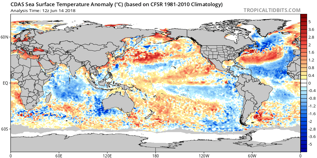
This SST anomaly configuration certainly doesn't have the signature of an active MDR. It continues to be 180 degree opposite of last year. All of the above normal SSTs are in the northern subtropical Atlantic. Of course we can't count out waves waiting to develop once they recurve into the subtropical Atlantic or make it further west in the Caribbean or Gulf. Of course we probably will still get a few MDR systems between the Lesser Antilles and Africa during the peak period of late Aug through September as the waters will be warm enough but I just can't see anything like last year in the MDR (between the Lesser Antilles and Africa) as far as systems being that strong out there:
3 likes
-
Weather150
- Tropical Storm

- Posts: 190
- Joined: Fri Jul 07, 2017 7:46 pm
Re: 2018 Indicators: SST's / MSLP / Sal / Steering / Shear / Instability (Graphic updates at first post)
gatorcane wrote:The posts in this forum are NOT official forecast and should not be used as such. They are just the opinion of the poster and may or may not be backed by sound meteorological data. They are NOT endorsed by any professional institution or STORM2K. For official information, please refer to products from the National Hurricane Center and National Weather Service.
This SST anomaly configuration certainly doesn't have the signature of an active MDR. It continues to be 180 degree opposite of last year. All of the above normal SSTs are in the northern subtropical Atlantic. Of course we can't count out waves waiting to develop once they recurve into the subtropical Atlantic or make it further west in the Caribbean or Gulf. Of course we probably will still get a few MDR systems between the Lesser Antilles and Africa during the peak period of late Aug through September as the waters will be warm enough but I just can't see anything like last year in the MDR (between the Lesser Antilles and Africa) as far as systems being that strong out there:
We could get some pretty strong hurricanes in the subtropics. I think we have a much higher chance of getting a major there than in the MDR this year, along with the Gulf.
3 likes
-
TheStormExpert
Re: 2018 Indicators: SST's / MSLP / Sal / Steering / Shear / Instability (Graphic updates at first post)
So with the likelihood of an El Niño developing at least midway through the season increasing are we still thinking 1985 is a good analog?
1 likes


Re: 2018 Indicators: SST's / MSLP / Sal / Steering / Shear / Instability (Graphic updates at first post)
the MDR anomalies have not improved, it continues the downward spiral and re-intensifying the cold horseshoe. The window to reverse this by fall is closing, there is already a feedback going on.

Agreed with posts above about Subtropics possibly being more favorable.
Remember, this is not about the actual SSTs but the spatial pattern created. Strong Azores high fed by the warmer waters in the north increases trades to the south, inducing shear. In the same motion creates more cooling.
Agreed with posts above about Subtropics possibly being more favorable.
Remember, this is not about the actual SSTs but the spatial pattern created. Strong Azores high fed by the warmer waters in the north increases trades to the south, inducing shear. In the same motion creates more cooling.
2 likes
The above post and any post by Ntxw is NOT an official forecast and should not be used as such. It is just the opinion of the poster and may or may not be backed by sound meteorological data. It is NOT endorsed by any professional institution including Storm2k. For official information, please refer to NWS products.
Help support Storm2K!
-
TheStormExpert
Re: 2018 Indicators: SST's / MSLP / Sal / Steering / Shear / Instability (Graphic updates at first post)
I’m not ready to write off this season just yet. I personally believe just like in 1985 that the Gulf Coast and mid-Atlantic to New England are at greatest risk from a Tropical Cycloneye strike. Wouldn’t rule out a hurricane hit or two in the U.S. this year. Not betting on a major hit, likely to be a less intense version of 1985 if anything.
0 likes

Re: 2018 Indicators: SST's / MSLP / Sal / Steering / Shear / Instability (Graphic updates at first post)
Ntxw wrote:the MDR anomalies have not improved, it continues the downward spiral and re-intensifying the cold horseshoe. The window to reverse this by fall is closing, there is already a feedback going on.
Agreed with posts above about Subtropics possibly being more favorable.
Remember, this is not about the actual SSTs but the spatial pattern created. Strong Azores high fed by the warmer waters in the north increases trades to the south, inducing shear. In the same motion creates more cooling.
One would think that this same pumped up W. Atlantic ridge might be the very reason that the Southeast CONUS might be at greater risk of whatever tropical cyclones might develop within or just north of the Caribbean. That 500 mb pattern might just be the westward railroad to landfalls. The hopeful counterbalance is that perhaps there will be few long trackers, that potential upper level conditions may pose persistent shear impact, or that the strong E. Trades themselves might mitigate particularly strong storms from developing as a result of hampered vertical continuity. This could well be a slow season but a more relevant point that should be considered is whether the pattern itself might be more conducive to a (or multiple) Florida to Carolina's eastward approaching storm or hurricane.
1 likes
Andy D
(For official information, please refer to the NHC and NWS products.)
(For official information, please refer to the NHC and NWS products.)
-
NotSparta
- Professional-Met
- Posts: 1677
- Age: 24
- Joined: Fri Aug 18, 2017 8:24 am
- Location: Naples, FL
- Contact:
Re: 2018 Indicators: SST's / MSLP / Sal / Steering / Shear / Instability (Graphic updates at first post)
The MDR should have a pause in the downward spiral, as a trade slowdown takes place. It's unclear how long this will last, however.

1 likes
This post was probably an opinion of mine, and in no way is official. Please refer to http://www.hurricanes.gov for official tropical analysis and advisories.
My website, with lots of tropical wx graphics, including satellite and recon: http://cyclonicwx.com
My website, with lots of tropical wx graphics, including satellite and recon: http://cyclonicwx.com
Re: 2018 Indicators: SST's / MSLP / Sal / Steering / Shear / Instability (Graphic updates at first post)
My observations of slowly evolving El Nino events were that there seemed to be a delayed impact (30-60 days perhaps?) to Atlantic conditions. Are you suggesting that outside of an actual El Nino event that even warm-neutral conditions would be a tell tale prelude to near term motion? Of course its possible that the 500 mb height falls that you are suggesting might not verify until Sept./Oct. That doesn't seem at all unreasonable but I'd be a bit surprised if you were suggesting a noticeable breakdown in the W. Atlantic heights as early as this July and August

0 likes
Andy D
(For official information, please refer to the NHC and NWS products.)
(For official information, please refer to the NHC and NWS products.)


Who is online
Users browsing this forum: No registered users and 193 guests