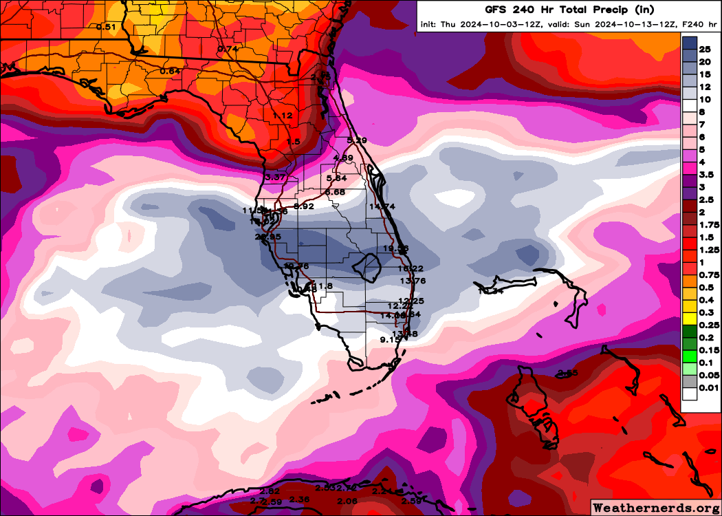
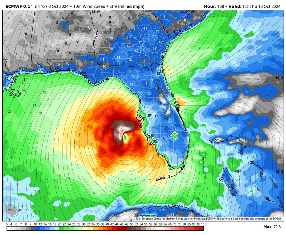
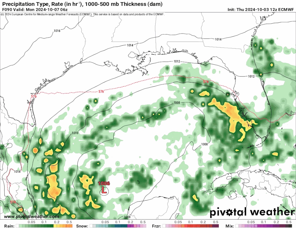
Possible development in the Gulf of Mexico (Is Invest 92L)

This is the general tropical discussion area. Anyone can take their shot at predicting a storms path.

Moderator: S2k Moderators

Forum rules

The posts in this forum are NOT official forecasts and should not be used as such. They are just the opinion of the poster and may or may not be backed by sound meteorological data. They are NOT endorsed by any professional institution or STORM2K. For official information, please refer to products from the National Hurricane Center and National Weather Service.

Help Support Storm2K
Message
Author
Nuno
Category 2
Category 2
Posts: 597
Joined: Fri Aug 30, 2019 8:35 am
Location: Coral Gables, FL

Re: Possible development in the Gulf of Mexico (0/30)

#381 Postby Nuno » Thu Oct 03, 2024 9:02 am

toad strangler wrote:
psyclone wrote:The longer something festers the more likely something eventually finds a way to happen. My gut leans toward development of something at some point...hosing the florida peninsula...which we definitely don't need..


Mike Lowry in his update this morning was talking about how this set up could be linked to the end of the wet season in South Florida when all is said and done. Very interesting information he delivered ...


Would be an early end for the wet season. It has been a soggy one, but I always feel oddly sad when it ends. The months of dryness often gets just as bad in the other direction.
0 likes   
Andrew (1992), Irene (1999), Frances (2004), Katrina (2005), Wilma (2005), Fay (2008), Irma (2017), Eta (2020), Ian (2022)

User avatar
wxman57
Moderator-Pro Met
Moderator-Pro Met
Posts: 22978
Age: 67
Joined: Sat Jun 21, 2003 8:06 pm
Location: Houston, TX (southwest)

Re: Possible development in the Gulf of Mexico (0/30)

#382 Postby wxman57 » Thu Oct 03, 2024 9:17 am

toad strangler wrote:
wxman57 wrote:
Stormlover70 wrote:will it affect my area?


You could get a couple inches of rain over the next week. Wind up to 10-15 mph. Offshore wind will be about 20-30 mph.


6z GFS give New Port Richey much more than that over the next 168. I take it you don't put much stock in global model QPF? FWIW Euro & CMC is much less impressed.


Nope, not with this system. The GFS has been terrible with it.
3 likes   

User avatar
Emmett_Brown
Category 5
Category 5
Posts: 1432
Joined: Wed Aug 24, 2005 9:10 pm
Location: Sarasota FL

Re: Possible development in the Gulf of Mexico (0/30)

#383 Postby Emmett_Brown » Thu Oct 03, 2024 9:32 am

The 0z Icon was still a bit feisty, showed 998 low approaching WC FL, so still one to watch IMO. 6Z was less enthusiastic but still somewhat well defined
0 likes   

psyclone
S2K Supporter
S2K Supporter
Posts: 4762
Joined: Wed Aug 24, 2005 9:04 pm
Location: palm harbor fl

Re: Possible development in the Gulf of Mexico (0/30)

#384 Postby psyclone » Thu Oct 03, 2024 11:57 am

I like the fact that nothing is happening so far. Still waiting on a cold front, a sub 70 dewpoint and a sub 100 heat index. At this point we are entitled to some slightly less miserable weather..
2 likes   

User avatar
chaser1
S2K Supporter
S2K Supporter
Posts: 5464
Age: 64
Joined: Sat Oct 15, 2005 5:59 pm
Location: Longwood, Fl

Re: Possible development in the Gulf of Mexico (0/30)

#385 Postby chaser1 » Thu Oct 03, 2024 12:06 pm

I'm just not feeling that models have a good handle on this. 12Z ICON now showing a 1003 mb further south primarily dragging across southernmost Florida. Meanwhile, the 12Z GFS showing consecutive model runs depicting approx 168 hr total precip accumulation of 20" of rain for nearly everywhere south of Kissimmee :lol: I'm not banking on that.
1 likes   
Andy D

(For official information, please refer to the NHC and NWS products.)

User avatar
SFLcane
S2K Supporter
S2K Supporter
Posts: 10163
Age: 47
Joined: Sat Jun 05, 2010 1:44 pm
Location: Lake Worth Florida

Re: Possible development in the Gulf of Mexico (0/30)

#386 Postby SFLcane » Thu Oct 03, 2024 12:10 pm

This might be just as bad as a TC just without the wind for the Florida Peninsula. :eek:

Image
1 likes   

ChrisH-UK
Category 2
Category 2
Posts: 625
Joined: Sat May 29, 2021 8:22 am

Re: Possible development in the Gulf of Mexico (0/30)

#387 Postby ChrisH-UK » Thu Oct 03, 2024 12:15 pm

You can see the starting of this, with a broad elongated rotation in the Gulf and Bay of Campeche, there's also convection happening with thunderstorms bubbling up. As for will anything happen, will see.

Image
0 likes   

User avatar
fci
S2K Supporter
S2K Supporter
Posts: 3324
Joined: Tue Sep 14, 2004 10:29 am
Location: Lake Worth, FL

Re: Possible development in the Gulf of Mexico (0/30)

#388 Postby fci » Thu Oct 03, 2024 12:27 pm

SFLcane wrote:This might be just as bad as a TC just without the wind for the Florida Peninsula. :eek:

https://i.postimg.cc/tTNRpP6m/kkk.png


Rainy season would go out with a bang.
Or maybe a slosh.
2 likes   
Personal Forecast Disclaimer:
My posts are just my opinion and are most likely not backed by sound meteorological data. They are NOT endorsed by any professional institution or storm2k.org. For official information, please refer to the NHC and NWS products.
Bottom line is that I am just expressing my opinion!!!

User avatar
Emmett_Brown
Category 5
Category 5
Posts: 1432
Joined: Wed Aug 24, 2005 9:10 pm
Location: Sarasota FL

Re: Possible development in the Gulf of Mexico (0/30)

#389 Postby Emmett_Brown » Thu Oct 03, 2024 12:30 pm

The 12Z GEFS shows a slight but clear uptick in activity and strength in the E GOM for Tues-Thurs next week vs the last few runs.
0 likes   

User avatar
cycloneye
Admin
Admin
Posts: 145295
Age: 68
Joined: Thu Oct 10, 2002 10:54 am
Location: San Juan, Puerto Rico

Re: Possible development in the Gulf of Mexico (0/30)

#390 Postby cycloneye » Thu Oct 03, 2024 12:48 pm

2 PM:

Gulf of Mexico:
Disorganized showers and thunderstorms over portions of the Gulf of
Mexico are associated with a surface trough. A broad area of low
pressure is likely to develop over the Gulf of Mexico this weekend
or early next week, but subsequent tropical or subtropical
development could be limited by the system's potential interaction
with a frontal boundary. Regardless of development, locally heavy
rains could occur over portions of Mexico during the next few days
and over portions of the Florida Peninsula from late this weekend
into next week.
* Formation chance through 48 hours...low...near 0 percent.
* Formation chance through 7 days...low...30 percent.
0 likes   
Visit the Caribbean-Central America Weather Thread where you can find at first post web cams,radars
and observations from Caribbean basin members Click Here

User avatar
SFLcane
S2K Supporter
S2K Supporter
Posts: 10163
Age: 47
Joined: Sat Jun 05, 2010 1:44 pm
Location: Lake Worth Florida

Re: Possible development in the Gulf of Mexico (0/30)

#391 Postby SFLcane » Thu Oct 03, 2024 12:59 pm

Image
0 likes   

User avatar
ThunderForce
Tropical Storm
Tropical Storm
Posts: 208
Age: 25
Joined: Tue Sep 27, 2022 6:20 pm
Location: Calhoun County, Florida

Re: Possible development in the Gulf of Mexico (0/30)

#392 Postby ThunderForce » Thu Oct 03, 2024 1:03 pm


Is... is that a hurricane?
0 likes   
Please refer to the NWS, NHC, SPC or a professional meteorologist for information and decision making during storms.

User avatar
SFLcane
S2K Supporter
S2K Supporter
Posts: 10163
Age: 47
Joined: Sat Jun 05, 2010 1:44 pm
Location: Lake Worth Florida

Re: Possible development in the Gulf of Mexico (0/30)

#393 Postby SFLcane » Thu Oct 03, 2024 1:03 pm

ThunderForce wrote:

Is... is that a hurricane?


Yes.. appears to be a cat 1
0 likes   

User avatar
boca
Category 5
Category 5
Posts: 6367
Age: 60
Joined: Mon Dec 15, 2003 8:49 am
Location: Boca Raton,FL

Re: Possible development in the Gulf of Mexico (0/30)

#394 Postby boca » Thu Oct 03, 2024 1:18 pm

SFLcane wrote:
ThunderForce wrote:

Is... is that a hurricane?


Yes.. appears to be a cat 1


Which way is it moving ?
0 likes   

User avatar
cycloneye
Admin
Admin
Posts: 145295
Age: 68
Joined: Thu Oct 10, 2002 10:54 am
Location: San Juan, Puerto Rico

Re: Possible development in the Gulf of Mexico (0/30)

#395 Postby cycloneye » Thu Oct 03, 2024 1:21 pm

boca wrote:
SFLcane wrote:
ThunderForce wrote:Is... is that a hurricane?


Yes.. appears to be a cat 1


Which way is it moving ?


Image
0 likes   
Visit the Caribbean-Central America Weather Thread where you can find at first post web cams,radars
and observations from Caribbean basin members Click Here

User avatar
SFLcane
S2K Supporter
S2K Supporter
Posts: 10163
Age: 47
Joined: Sat Jun 05, 2010 1:44 pm
Location: Lake Worth Florida

Re: Possible development in the Gulf of Mexico (0/30)

#396 Postby SFLcane » Thu Oct 03, 2024 1:22 pm

boca wrote:
SFLcane wrote:
ThunderForce wrote:Is... is that a hurricane?


Yes.. appears to be a cat 1


Which way is it moving ?


Image
0 likes   

User avatar
TreasureIslandFLGal
S2K Supporter
S2K Supporter
Posts: 1581
Age: 57
Joined: Sun Aug 15, 2004 6:16 pm
Location: Clearwater, Florida ~3 miles from the coast now. We finally moved safely off the barrier island!

Re: Possible development in the Gulf of Mexico (0/30)

#397 Postby TreasureIslandFLGal » Thu Oct 03, 2024 1:25 pm

SFLcane wrote:This might be just as bad as a TC just without the wind for the Florida Peninsula. :eek:

https://i.postimg.cc/tTNRpP6m/kkk.png


That's 10days worth of total/accumulating precip. I think that looks a lot worse than it may really be. We have daily thunderstorms and rain as part of our regular summer "rainy season" pattern, and can easily get significant rain each day in spurts, and that adds up quickly. That said though, any incoming storm or front provides added juice to the pattern and can result in longer lasting rain episodes. We could get 5" from a small storm easily, in addition to the daily deluges to expect for a couple more weeks until the pattern shifts to little rain until May. (It seems to be Oct 25- May 25 is the Pinellas County dry season)
0 likes   
Chrissy & Ligeia
:flag:

User avatar
TreasureIslandFLGal
S2K Supporter
S2K Supporter
Posts: 1581
Age: 57
Joined: Sun Aug 15, 2004 6:16 pm
Location: Clearwater, Florida ~3 miles from the coast now. We finally moved safely off the barrier island!

Re: Possible development in the Gulf of Mexico (0/30)

#398 Postby TreasureIslandFLGal » Thu Oct 03, 2024 1:29 pm

SFLcane wrote:
boca wrote:
SFLcane wrote:
Yes.. appears to be a cat 1


Which way is it moving ?


https://i.postimg.cc/8cbq7mkx/BBB.gif


almost comical how the "Tampa Bay Shield" gets depicted with this run!
0 likes   
Chrissy & Ligeia
:flag:

jlauderdal
S2K Supporter
S2K Supporter
Posts: 7182
Joined: Wed May 19, 2004 5:46 am
Location: NE Fort Lauderdale
Contact:

Re: Possible development in the Gulf of Mexico (0/30)

#399 Postby jlauderdal » Thu Oct 03, 2024 1:32 pm

TreasureIslandFLGal wrote:
SFLcane wrote:
boca wrote:
Which way is it moving ?


https://i.postimg.cc/8cbq7mkx/BBB.gif


almost comical how the "Tampa Bay Shield" gets depicted with this run!

Dirty side of the storm, Im going with 57s idea on intensity until the models consistently show me something that makes more sense. I saw his post about a couple of inches of rain for sofla and in my world a couple is 2 so we will give him 2.99 but even that seems a little light.
0 likes   

User avatar
ColdMiser123
Professional-Met
Professional-Met
Posts: 904
Age: 29
Joined: Mon Sep 26, 2016 3:26 pm
Location: Northeast US

Re: Possible development in the Gulf of Mexico (0/30)

#400 Postby ColdMiser123 » Thu Oct 03, 2024 1:36 pm

Still a lot that can happen with this. Has been a complicated system with many vorticity centers, so models have generally struggled to resolve a particular outcome.

Latest EPS focuses on any US impacts to be across Florida.

Image
2 likes   
B.S., M.S., Meteorology & Atmospheric Science


Return to “Talkin' Tropics”

Who is online

Users browsing this forum: Google Adsense [Bot], hurricanes1234, IsabelaWeather and 32 guests