2021 Indicators: SST's / SAL / MSLP / Shear / Steering / Instability / Sat Images

This is the general tropical discussion area. Anyone can take their shot at predicting a storms path.

Moderator: S2k Moderators

Forum rules

The posts in this forum are NOT official forecasts and should not be used as such. They are just the opinion of the poster and may or may not be backed by sound meteorological data. They are NOT endorsed by any professional institution or STORM2K. For official information, please refer to products from the National Hurricane Center and National Weather Service.

Help Support Storm2K
Message
Author
AlphaToOmega
Category 5
Category 5
Posts: 1448
Joined: Sat Jun 26, 2021 10:51 am
Location: Somewhere in Massachusetts

Re: 2021 Indicators: SST's / SAL / MSLP / Shear / Steering / Instability / Sat Images

#3821 Postby AlphaToOmega » Wed Oct 06, 2021 3:14 pm

Moreover, here is the shear map of September 1998 (the year of Hurricane Mitch)
Image
High wind shear in September =/= lack of major hurricane threats in October and November
1 likes   

User avatar
Category5Kaiju
Category 5
Category 5
Posts: 4095
Joined: Thu Dec 24, 2020 12:45 pm
Location: Seattle

Re: 2021 Indicators: SST's / SAL / MSLP / Shear / Steering / Instability / Sat Images

#3822 Postby Category5Kaiju » Wed Oct 06, 2021 3:32 pm

hurricanetrack wrote:Figured I would post my video discussion for today here since it is relevant to this thread towards the end. MJO looks to swing back around and the overall pattern at least suggests that it's not over 'til it's over...which it's not by default anyway but you get the gist...

https://youtu.be/SW6BYhMTyf8


Thank you so much for the very concise explanation you gave in your recent video on why people should not see this season as having ended. It certainly does feel like there's a bit too much nowcasting and model-hugging going on, and I feel like it is best to stay alert until the finish line rather than become complacent based on very vague factors and then end up very shocked and confused in the event a major hurricane forms after October 15 and threatens land.
4 likes   
Unless explicitly stated, all info in my posts is based on my own opinions and observations. Tropical storms and hurricanes can be extremely dangerous. Do not think you can beat Mother Nature. Refer to an accredited weather research agency or meteorologist if you need to make serious decisions regarding an approaching storm.

User avatar
WiscoWx02
Category 1
Category 1
Posts: 391
Joined: Sat Jul 31, 2021 8:09 pm

Re: 2021 Indicators: SST's / SAL / MSLP / Shear / Steering / Instability / Sat Images

#3823 Postby WiscoWx02 » Wed Oct 06, 2021 5:18 pm


Looks like the best bet at me being proven wrong will indeed be the tail end of October and early November...quite a ways off but makes sense given the nature of MJO propagation and where it is now. Will be interesting to see if it does indeed work into the Atlantic or if it just gets cutoff in the null phase, which is a possibility.
0 likes   

User avatar
toad strangler
S2K Supporter
S2K Supporter
Posts: 4543
Joined: Sun Jul 28, 2013 3:09 pm
Location: Earth
Contact:

Re: 2021 Indicators: SST's / SAL / MSLP / Shear / Steering / Instability / Sat Images

#3824 Postby toad strangler » Wed Oct 06, 2021 5:35 pm

Category5Kaiju wrote:
hurricanetrack wrote:Figured I would post my video discussion for today here since it is relevant to this thread towards the end. MJO looks to swing back around and the overall pattern at least suggests that it's not over 'til it's over...which it's not by default anyway but you get the gist...

https://youtu.be/SW6BYhMTyf8


Thank you so much for the very concise explanation you gave in your recent video on why people should not see this season as having ended. It certainly does feel like there's a bit too much nowcasting and model-hugging going on, and I feel like it is best to stay alert until the finish line rather than become complacent based on very vague factors and then end up very shocked and confused in the event a major hurricane forms after October 15 and threatens land.


I don't dump my gas into the vehicles until mid Nov if all looks clear at that point. That's how I stay alert. Not sure who you are referring to who would be "shocked and confused" at a late October threat given quiet globals. That sounds a bit extreme TBH. Modeling is what it is. Tools for the pros, which most of us are not, including me! I do remember 1985 though. The anomalous CONUS late season year in the S western basin of all CONUS anomalous recorded years in the S western basin. There is NEVER a surprise!

So, what are we left with? A waiting game with some important indicators like the MJO, -ENSO, the lack of a western basin season ending front anywhere on the horizon for some areas, and warm SST's. Always watch. Never be surprised.
0 likes   

User avatar
abajan
S2K Supporter
S2K Supporter
Posts: 4230
Joined: Sun Sep 07, 2003 5:10 am
Location: Barbados

Re: 2021 Indicators: SST's / SAL / MSLP / Shear / Steering / Instability / Sat Images

#3825 Postby abajan » Wed Oct 06, 2021 6:06 pm

hurricanetrack wrote:Figured I would post my video discussion for today here since it is relevant to this thread towards the end. MJO looks to swing back around and the overall pattern at least suggests that it's not over 'til it's over...which it's not by default anyway but you get the gist...

https://youtu.be/SW6BYhMTyf8

I was just about to post that video!
But who better than its creator to do it? :lol:
0 likes   

AlphaToOmega
Category 5
Category 5
Posts: 1448
Joined: Sat Jun 26, 2021 10:51 am
Location: Somewhere in Massachusetts

Re: 2021 Indicators: SST's / SAL / MSLP / Shear / Steering / Instability / Sat Images

#3826 Postby AlphaToOmega » Wed Oct 06, 2021 6:38 pm

Posted in the 2021 EPac Season thread, but here you go:

 https://twitter.com/philklotzbach/status/1445847301331685377


1 likes   

User avatar
Teban54
Category 5
Category 5
Posts: 3204
Joined: Sat May 19, 2018 1:19 pm

Re: 2021 Indicators: SST's / SAL / MSLP / Shear / Steering / Instability / Sat Images

#3827 Postby Teban54 » Wed Oct 06, 2021 9:09 pm

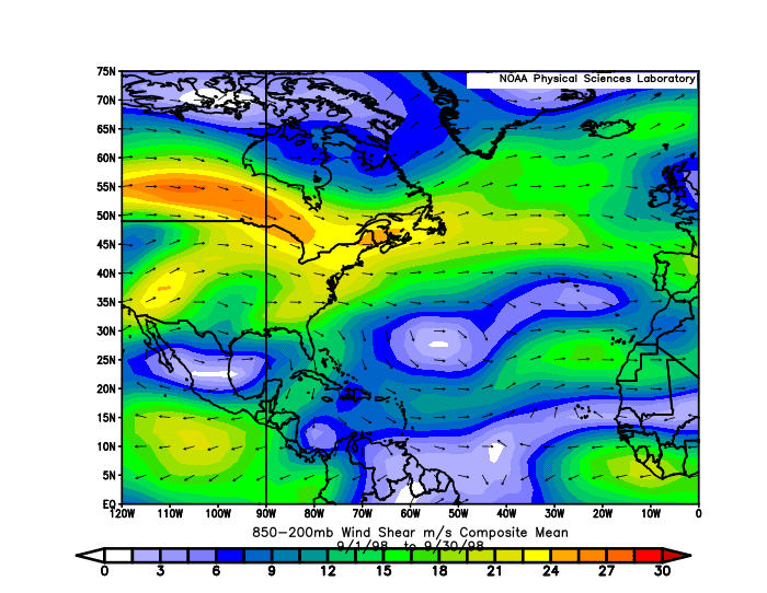
AlphaToOmega wrote:Moreover, here is the shear map of September 1998 (the year of Hurricane Mitch)
https://i.postimg.cc/GpfBKNV8/compday-Xh4-Jb-O8-E4-R.gif
High wind shear in September =/= lack of major hurricane threats in October and November

I had been using 1998 as an analog since mid September, primarily based on the pattern of activity bursts with a lull in mid September and then early October.

Fortunately our version of Georges actually recurved instead of roaring through every piece of land. But that also means we're nowhere out of the woods from having a Mitch-like storm, and the potential time frame would also match Mitch quite well.

Oh, and the Phil Klotzbach tweet above regarding EPac is yet another similarity with 1998.
1 likes   

User avatar
Teban54
Category 5
Category 5
Posts: 3204
Joined: Sat May 19, 2018 1:19 pm

Re: 2021 Indicators: SST's / SAL / MSLP / Shear / Steering / Instability / Sat Images

#3828 Postby Teban54 » Wed Oct 06, 2021 10:42 pm

A gentle reminder for those using current shear to make predictions: There was strong, El Nino-like shear in the basin on October 2, 2020. Here are a few posts in the 2020 indicators thread, right before Gamma and Delta both formed and RIed:
Quite a lot of shear out in the Atlantic right now. Definitely more El Niño-ish.

Image

Image

Yeah the atmosphere sure isn't acting like a La Niña right now given all that shear. Plus an active Cat 4 in the EPAC right now.

I doubt that the phase of the MJO and/or the passage of a downwelling CCKW, either alone or by themselves, can account for such high VWS during La Niña.

I remember there were a few posts this week trying to draw similar conclusions for the 2021 season. We'll see if the "El Nino-like conditions" end up correct or not, but with the SSTs clearly showing a La Nina, my bet is that the atmosphere will catch up sooner or later (a lag between the catchup is nothing unusual).
2 likes   

User avatar
Hammy
Category 5
Category 5
Posts: 5849
Age: 41
Joined: Fri May 25, 2012 5:25 pm
Contact:

Re: 2021 Indicators: SST's / SAL / MSLP / Shear / Steering / Instability / Sat Images

#3829 Postby Hammy » Wed Oct 06, 2021 11:30 pm

:uarrow: If anything the posts last year made no sense given there was already a developing system and we were days away (with strong model support) from another. Quite the opposite at the moment.
0 likes   
The above post is not official and should not be used as such. It is the opinion of the poster and may or may not be backed by sound meteorological data. It is not endorsed by any professional institution or storm2k.org. For official information, please refer to the NHC and NWS products.

User avatar
Steve
S2K Supporter
S2K Supporter
Posts: 9620
Joined: Sat Apr 05, 2003 11:41 pm
Location: Not a state-caster

Re: 2021 Indicators: SST's / SAL / MSLP / Shear / Steering / Instability / Sat Images

#3830 Postby Steve » Wed Oct 06, 2021 11:37 pm

VP200 anomalies look solid for the next 2 weeks. You’d expect that to coincide with the MJO if it goes as some of the models are forecasting. It’s later into October where we hit next round of favorability. So any potential tracks have to factor that in. There’s been some hint of maybe a cut off system in the WATL. Plausible for time adjusted. But I wonder if all things considered we don’t end up with a few more hurricanes.

http://mikeventrice.weebly.com/mjo.html
1 likes   

Shell Mound
Category 5
Category 5
Posts: 2434
Age: 32
Joined: Thu Sep 07, 2017 3:39 pm
Location: St. Petersburg, FL → Scandinavia

Re: 2021 Indicators: SST's / SAL / MSLP / Shear / Steering / Instability / Sat Images

#3831 Postby Shell Mound » Thu Oct 07, 2021 1:22 am

Both 1998 and 2016 followed strong Niños, so one would expect lingering VWS in the Caribbean. Enhanced VWS during double-dip, back-to-back Niñas, however, is quite atypical. In this respect 2021 has behaved more like a Niño-to-Niña rather than Niña-to-Niña sequence/transition, especially in the western MDR and eastern two-third of the Caribbean. One would have expected lower VWS there during a consecutive Niña year.
3 likes   
CVW / MiamiensisWx / Shell Mound
The posts in this forum are NOT official forecasts and should not be used as such. They are just the opinion of the poster and may or may not be backed by sound meteorological data. They are NOT endorsed by any professional institution or STORM2K. For official information, please refer to products from the NHC and NWS.

User avatar
Category5Kaiju
Category 5
Category 5
Posts: 4095
Joined: Thu Dec 24, 2020 12:45 pm
Location: Seattle

Re: 2021 Indicators: SST's / SAL / MSLP / Shear / Steering / Instability / Sat Images

#3832 Postby Category5Kaiju » Thu Oct 07, 2021 6:46 am

I have been following the EPAC indicators thread recently, and it looks like some models like the GFS and Euro have been backing off on future-Pamela's intensity a bit. This imho would mean 2 things IF the trends were to continue: better news for Mexico, but also a highlight of how unfavorable conditions for the EPAC truly are given it's a La Nina baseline year (which would give some credance to the Atlantic benefiting in activity potential later this month). Also keep in mind the WPAC has been featuring pretty broad, sloppy monsoonal messes (as somebody earlier in this thread pointed out), and imho I do not see anything atypical about this sort of pattern given the La Nina's impending nature. Remember, La Nina years do not always have a shear-free Atlantic.
3 likes   
Unless explicitly stated, all info in my posts is based on my own opinions and observations. Tropical storms and hurricanes can be extremely dangerous. Do not think you can beat Mother Nature. Refer to an accredited weather research agency or meteorologist if you need to make serious decisions regarding an approaching storm.

User avatar
aspen
Category 5
Category 5
Posts: 8818
Joined: Sat Oct 12, 2019 7:10 pm
Location: Connecticut, USA

Re: 2021 Indicators: SST's / SAL / MSLP / Shear / Steering / Instability / Sat Images

#3833 Postby aspen » Thu Oct 07, 2021 10:17 am

Quite a strange look on the SST anomaly maps: while the Atlantic is running above-average (with the exception of Sam and Victor’s cold wakes) and the Niño regions are much below average, the EPac is actually WAY warmer than normal. Raw SSTs are on par with the Caribbean, and SSTAs are even higher, probably approaching +1.0C in some areas.

IMO, these warm EPac anomalies coupled with the passing Kelvin Wave and the genesis of Pamela will, for a time, result in sinking motion over the Caribbean that’ll eventually be countered around October 15-20th as the Kelvin Wave moves to become centered over the western Atlantic. Therefore, it’ll take a little more time before the Atlantic is ready for one final phase of activity.
3 likes   
Irene '11 Sandy '12 Hermine '16 5/15/2018 Derecho Fay '20 Isaias '20 Elsa '21 Henri '21 Ida '21

I am only a meteorology enthusiast who knows a decent amount about tropical cyclones. Look to the professional mets, the NHC, or your local weather office for the best information.

AlphaToOmega
Category 5
Category 5
Posts: 1448
Joined: Sat Jun 26, 2021 10:51 am
Location: Somewhere in Massachusetts

Re: 2021 Indicators: SST's / SAL / MSLP / Shear / Steering / Instability / Sat Images

#3834 Postby AlphaToOmega » Thu Oct 07, 2021 8:33 pm

All models indicate an active period from mid-October to mid-November. Beyond the scope of global models, climate models indicate an active November and December in the subtropics. Climate models also indicate that favorable conditions will continue into later this month and into November. Moreover, the general sea surface patterns (below-average ENSO, below-average PDO, below-average IOD, above-average AMO, and above-average TNA) would all concentrate rising air to the North Atlantic. Should this verify as modelled, 2021 could end the season just as 2005 did.

In terms of impacts, Florida is the primary concern. Later this month, a ridge is forecast is form in Quebec and Ontario, and an area of lower 500mb heights is expected to form along the Gulf Stream, a height pattern seen in late October of 2005. Therefore, storms are likely to be steered towards South Florida. Moreover, the Greater Antilles should be of concern for similar reasons.

Large-scale conditions

Currently conditions are unfavorable for development because of an unfavorable MJO phase. However, disregarding intraseasonal variation, conditions have been near-perfect for tropical cyclogenesis in the North Atlantic. Sea surface temperature patterns have been perfect for tropical cyclogenesis in the North Atlantic, and there has been an African Standing Wave that has kept September active despite an unfavorable MJO phase ever since the peak of hurricane season; and there is no indication that any of this will stop. The monthly runs of the CFSv2, JMA, and CanSIPS all showed velocity potential patterns that favored the North Atlantic.

Steering patterns look bad for Florida and the Antilles. Strong ridging is forecast near the Hudson Bay, and a weakness in the ridge is forecast in the open Atlantic. Similar riding patterns were seen in late October 2005, which featured Hurricane Wilma. The CFSv2 has consistently showed this pattern since September 30, so this model run is not an anomaly; it could mean bad news for Florida.

Forecast height anomalies:
Image

Late October 2005 height anomalies:
Image

Model runs

As of now, the GFS, ECMWF, CMC, ICON, and CFSv2 all support development of Invest 92L; the GEFS also supports development of Invest 92L. All of the beforementioned models show a low between 1000 and 1010 millibars, which would likely qualify it as a weak, short-lived tropical storm. If no storms developed between now and the potential formation of Invest 92L, it would be named Tropical Storm "Wanda". On all global models, Invest 92L makes landfall in North Carolina, and its vorticity is absorbed by other systems. Due to its small size and weak force, no major impacts are expected for Invest 92L.

The ECMWF shows two possible tropical cyclones of subtropical origin developing later this month, neither of which impacting land. The GFS and GEFS show a tropical wave developing into a tropical cyclone around October 15.
2 likes   

User avatar
Category5Kaiju
Category 5
Category 5
Posts: 4095
Joined: Thu Dec 24, 2020 12:45 pm
Location: Seattle

Re: 2021 Indicators: SST's / SAL / MSLP / Shear / Steering / Instability / Sat Images

#3835 Postby Category5Kaiju » Fri Oct 08, 2021 6:48 am

Interestingly, I feel like the most recent GFS run (remember, GFS has been pretty good this year) may hold clues as to what may be coming in the Atlantic soon. The WPAC struggles with broad systems that never become compact while the EPAC generates a strong Pamela but afterwards has no foreseeable storms form (this run does make sense given the La Niña base state otherwise). While nothing major appears in the Atlantic anytime soon, I sincerely believe that things will change after October 20 or so and that as of now the EPAC-shearing the Atlantic bias in the models and the lack of seeing the MJO progression may be why nothing forms in the Atlantic. Also let’s keep in mind that seeing 5 majors and 7 storms all in October and November like last year is pretty absurd and not normal at all; if anything I think some are a bit spoiled from last year, and imho we should expect 5 more storms and 2 more majors max this year.


Also, a recently published news article I found interesting as we head into October by WeatherTiger:
https://www.tallahassee.com/story/news/2021/10/08/mid-october-florida-hurricane-forecast-sam-victor-wanda-models-path/6046269001/


Imho, the most important piece of this article is near the end, and that is this:

"I would expect rising chances of tropical activity in or near the western Caribbean in the October 15th through 25th range.Frankly, it would be shocking if nothing developed in the Caribbean in October, given an incipient La Niña and above-average ocean temperatures, which augur increased odds of late-season activity.

That timing is consistent with the secondary peak in South Florida historical hurricane activity between the second and fourth weeks of October. In North Florida and the northern Gulf Coast, the climatological landfall rate drops off after mid-month.

However, Category 3 Hurricane Zeta’s Louisiana landfall on October 28th of last year shows you aren’t completely out of the woods yet there, either."
6 likes   
Unless explicitly stated, all info in my posts is based on my own opinions and observations. Tropical storms and hurricanes can be extremely dangerous. Do not think you can beat Mother Nature. Refer to an accredited weather research agency or meteorologist if you need to make serious decisions regarding an approaching storm.

AlphaToOmega
Category 5
Category 5
Posts: 1448
Joined: Sat Jun 26, 2021 10:51 am
Location: Somewhere in Massachusetts

Re: 2021 Indicators: SST's / SAL / MSLP / Shear / Steering / Instability / Sat Images

#3836 Postby AlphaToOmega » Fri Oct 08, 2021 2:24 pm

The EPS forecasts favorable VP patterns from now into late November.

Image
0 likes   

AlphaToOmega
Category 5
Category 5
Posts: 1448
Joined: Sat Jun 26, 2021 10:51 am
Location: Somewhere in Massachusetts

Re: 2021 Indicators: SST's / SAL / MSLP / Shear / Steering / Instability / Sat Images

#3837 Postby AlphaToOmega » Fri Oct 08, 2021 2:51 pm

The CFS has, for a while, been showing possible development near the Iberian Peninsula/West Africa later in October, November, and December. This area tends to be active later in the season, with storms such as Delta (2005), Epsilon (2005), Pablo (2019), and Theta (2020).

Image

Image

Image
0 likes   

User avatar
Category5Kaiju
Category 5
Category 5
Posts: 4095
Joined: Thu Dec 24, 2020 12:45 pm
Location: Seattle

Re: 2021 Indicators: SST's / SAL / MSLP / Shear / Steering / Instability / Sat Images

#3838 Postby Category5Kaiju » Fri Oct 08, 2021 2:55 pm

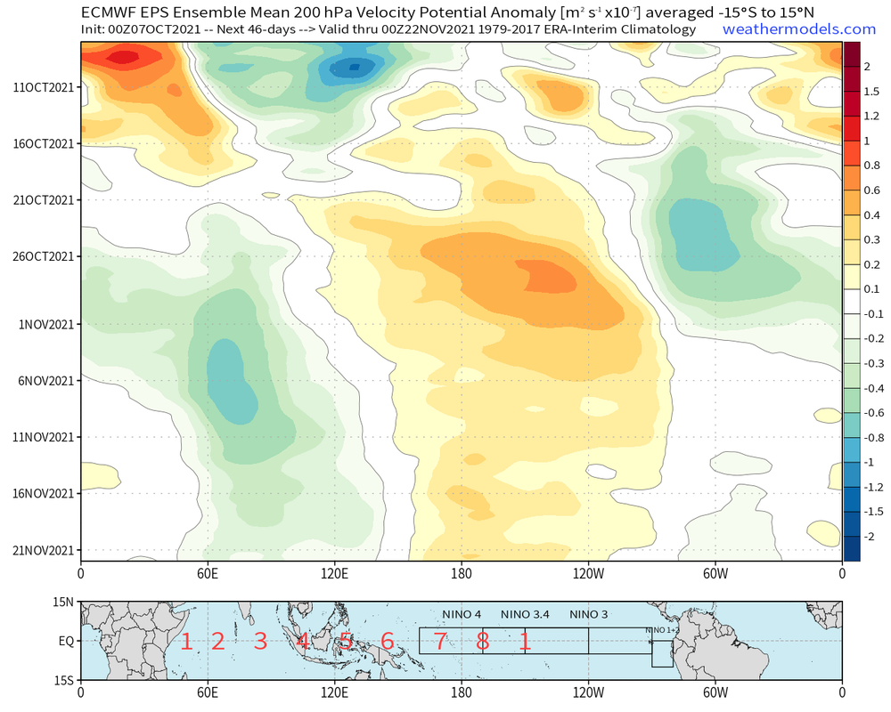
AlphaToOmega wrote:The EPS forecasts favorable VP patterns from now into late November.

https://i.postimg.cc/PqSYr22f/eps-chi200-anomaly-hov-equatorial-2021100700-MEAN.png


If that VP pattern were to believed, then that really suggests a very favorable W Atlantic look post-Pamela landfall in the Atlantic (especially with EPAC sinking). Just by looking at that, I am inclined to believe that this upcoming CCKW is going to really surprise those who firmly believe that season's over after Sam.
0 likes   
Unless explicitly stated, all info in my posts is based on my own opinions and observations. Tropical storms and hurricanes can be extremely dangerous. Do not think you can beat Mother Nature. Refer to an accredited weather research agency or meteorologist if you need to make serious decisions regarding an approaching storm.

User avatar
Hammy
Category 5
Category 5
Posts: 5849
Age: 41
Joined: Fri May 25, 2012 5:25 pm
Contact:

Re: 2021 Indicators: SST's / SAL / MSLP / Shear / Steering / Instability / Sat Images

#3839 Postby Hammy » Fri Oct 08, 2021 3:28 pm

Likely owing to stronger fronts and more shear, the CFS has been gradually backing off of the intensity of the Caribbean storms its showing during October and November, though (with varying timeframes) it still seems to show up to three more systems forming.
0 likes   
The above post is not official and should not be used as such. It is the opinion of the poster and may or may not be backed by sound meteorological data. It is not endorsed by any professional institution or storm2k.org. For official information, please refer to the NHC and NWS products.

User avatar
aspen
Category 5
Category 5
Posts: 8818
Joined: Sat Oct 12, 2019 7:10 pm
Location: Connecticut, USA

Re: 2021 Indicators: SST's / SAL / MSLP / Shear / Steering / Instability / Sat Images

#3840 Postby aspen » Fri Oct 08, 2021 3:43 pm

If Pamela does become a strong major (Cat 4 or higher) and the Atlantic fails to produce anything in the next 3-4 weeks — despite the VP setup and ENSO setup favoring activity in the Caribbean over the EPac — then clearly something anomalous is going on. Could it just be the atmosphere taking a long time to adjust to the La Niña, or something else at play?

This year worldwide has been very strange in terms of TC activity, with many droughts and peaks across all three big NHem basins. The Atlantic has had plenty of peaks (late June, Aug20th-Sep5th, late September) and droughts (July10th-Aug10th, mid September), but so have both Pacific basins. The EPac was pumping out storms at a surprisingly good rate before shutting down after Olaf, and the WPac went without a single major for over 4 months before producing back-to-back Cat 5s (Chanthu and Mindulle).
1 likes   
Irene '11 Sandy '12 Hermine '16 5/15/2018 Derecho Fay '20 Isaias '20 Elsa '21 Henri '21 Ida '21

I am only a meteorology enthusiast who knows a decent amount about tropical cyclones. Look to the professional mets, the NHC, or your local weather office for the best information.


Return to “Talkin' Tropics”

Who is online

Users browsing this forum: Google Adsense [Bot], hurricanes1234, IsabelaWeather and 32 guests