2021 Indicators: SST's / SAL / MSLP / Shear / Steering / Instability / Sat Images

This is the general tropical discussion area. Anyone can take their shot at predicting a storms path.

Moderator: S2k Moderators

Forum rules

The posts in this forum are NOT official forecasts and should not be used as such. They are just the opinion of the poster and may or may not be backed by sound meteorological data. They are NOT endorsed by any professional institution or STORM2K. For official information, please refer to products from the National Hurricane Center and National Weather Service.

Help Support Storm2K
Message
Author
AlphaToOmega
Category 5
Category 5
Posts: 1448
Joined: Sat Jun 26, 2021 10:51 am
Location: Somewhere in Massachusetts

Re: 2021 Indicators: SST's / SAL / MSLP / Shear / Steering / Instability / Sat Images

#3901 Postby AlphaToOmega » Sun Oct 10, 2021 11:29 am

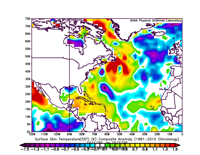
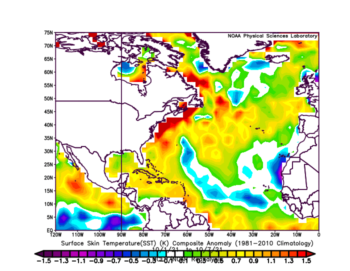
This time of year, wind shear AND SSTs have been more favorable than last year. With an imminent CCKW, the models probably need a new pair of prescription glasses.

Image
Image
2 likes   

LarryWx
Category 5
Category 5
Posts: 5813
Joined: Sun Sep 07, 2003 2:04 pm
Location: GA

Re: 2021 Indicators: SST's / SAL / MSLP / Shear / Steering / Instability / Sat Images

#3902 Postby LarryWx » Sun Oct 10, 2021 11:45 am

AlphaToOmega wrote:This time of year, wind shear AND SSTs have been more favorable than last year. With an imminent CCKW, the models probably need a new pair of prescription glasses.

https://i.postimg.cc/7L10RxXh/compday-OKjt5-BBUw-F.gif
https://i.postimg.cc/VNPX4Sq2/compday-w-Ku-Np-J3-ri.gif


I think you’re overstating the threat based on climo back to 1851, even taking into account global warming/warmer oceans. Once past 10/21, the climo based threat starts to drop pretty markedly. Just like climo says to stay on pretty high alert for possible threats through about 10/21, that same climo also says that the threat level begins to ease pretty sharply just afterward.

With GEFS/EPS/GEPS still showing no more than a small % of members with threats at any point in time through 10/25 and with models having done quite well recently with their call for a quiet first half of October/very quiet second peak, I’d say that we can now say that the threat level to land masses of anything of a high impact is coming down markedly. Not near zero yet, but getting down pretty low now even with La Niña redeveloping and Caribbean SSTs at their warmest so far this season. However, I’d still be wary about the POSSIBILITY of more activity forming mainly in the W Caribbean. I’m not saying the season is over yet even with the threat level dropping quite a bit.
7 likes   
Personal Forecast Disclaimer:
The posts in this forum are NOT official forecasts and should not be used as such. They are just the opinion of the poster and may or may not be backed by sound meteorological data. They are NOT endorsed by any professional institution or storm2k.org. For official information, please refer to the NHC and NWS products.

User avatar
Category5Kaiju
Category 5
Category 5
Posts: 3447
Age: 22
Joined: Thu Dec 24, 2020 12:45 pm
Location: Seattle

Re: 2021 Indicators: SST's / SAL / MSLP / Shear / Steering / Instability / Sat Images

#3903 Postby Category5Kaiju » Sun Oct 10, 2021 12:30 pm

Ok, so the most recent GFS operational run shows nothing significant develop in the WPAC after the current storms dissipate throughout the month, while in the EPAC nothing significant forms after Pamela throughout the month, and in the Atlantic of course nothing significant forms throughout the month. I... I don't know what's happening here quite frankly.
0 likes   
Unless explicitly stated, all information covered in my posts is based on my opinions and observations. Please refer to a professional meteorologist or an accredited weather research agency otherwise, especially if serious decisions must be made in the event of a potentially life-threatening tropical storm or hurricane.

User avatar
toad strangler
S2K Supporter
S2K Supporter
Posts: 4178
Joined: Sun Jul 28, 2013 3:09 pm
Location: Earth
Contact:

Re: 2021 Indicators: SST's / SAL / MSLP / Shear / Steering / Instability / Sat Images

#3904 Postby toad strangler » Sun Oct 10, 2021 12:35 pm

LarryWx wrote:
AlphaToOmega wrote:This time of year, wind shear AND SSTs have been more favorable than last year. With an imminent CCKW, the models probably need a new pair of prescription glasses.

https://i.postimg.cc/7L10RxXh/compday-OKjt5-BBUw-F.gif
https://i.postimg.cc/VNPX4Sq2/compday-w-Ku-Np-J3-ri.gif


I think you’re overstating the threat based on climo back to 1851, even taking into account global warming/warmer oceans. Once past 10/21, the climo based threat starts to drop pretty markedly. Just like climo says to stay on pretty high alert for possible threats through about 10/21, that same climo also says that the threat level begins to ease pretty sharply just afterward.

With GEFS/EPS/GEPS still showing no more than a small % of members with threats at any point in time through 10/25 and with models having done quite well recently with their call for a quiet first half of October/very quiet second peak, I’d say that we can now say that the threat level to land masses of anything of a high impact is coming down markedly. Not near zero yet, but getting down pretty low now even with La Niña redeveloping and Caribbean SSTs at their warmest so far this season. However, I’d still be wary about the POSSIBILITY of more activity forming mainly in the W Caribbean. I’m not saying the season is over yet even with the threat level dropping quite a bit.


Yep, as far as the CONUS goes, a depression or TS type system is definitely on the table going into very late OCT and through most of November. But, the chances of a hurricane landfall have already begun to free fall given short to mid range model output combined with the ever advancing calendar. Climo's influence will only grow stronger by the day starting in less than two weeks.
1 likes   

User avatar
SFLcane
S2K Supporter
S2K Supporter
Posts: 9627
Age: 46
Joined: Sat Jun 05, 2010 1:44 pm
Location: Lake Worth Florida

Re: 2021 Indicators: SST's / SAL / MSLP / Shear / Steering / Instability / Sat Images

#3905 Postby SFLcane » Sun Oct 10, 2021 1:18 pm

toad strangler wrote:
LarryWx wrote:
AlphaToOmega wrote:This time of year, wind shear AND SSTs have been more favorable than last year. With an imminent CCKW, the models probably need a new pair of prescription glasses.

https://i.postimg.cc/7L10RxXh/compday-OKjt5-BBUw-F.gif
https://i.postimg.cc/VNPX4Sq2/compday-w-Ku-Np-J3-ri.gif


I think you’re overstating the threat based on climo back to 1851, even taking into account global warming/warmer oceans. Once past 10/21, the climo based threat starts to drop pretty markedly. Just like climo says to stay on pretty high alert for possible threats through about 10/21, that same climo also says that the threat level begins to ease pretty sharply just afterward.

With GEFS/EPS/GEPS still showing no more than a small % of members with threats at any point in time through 10/25 and with models having done quite well recently with their call for a quiet first half of October/very quiet second peak, I’d say that we can now say that the threat level to land masses of anything of a high impact is coming down markedly. Not near zero yet, but getting down pretty low now even with La Niña redeveloping and Caribbean SSTs at their warmest so far this season. However, I’d still be wary about the POSSIBILITY of more activity forming mainly in the W Caribbean. I’m not saying the season is over yet even with the threat level dropping quite a bit.


Yep, as far as the CONUS goes, a depression or TS type system is definitely on the table going into very late OCT and through most of November. But, the chances of a hurricane landfall have already begun to free fall given short to mid range model output combined with the ever advancing calendar. Climo's influence will only grow stronger by the day starting in less than two weeks.


It’s over for the Conus and Florida i feel pretty good about that. If and that’s a big if something develops in the Caribbean it will likely stay down there.
0 likes   

LarryWx
Category 5
Category 5
Posts: 5813
Joined: Sun Sep 07, 2003 2:04 pm
Location: GA

Re: 2021 Indicators: SST's / SAL / MSLP / Shear / Steering / Instability / Sat Images

#3906 Postby LarryWx » Sun Oct 10, 2021 1:21 pm

SFLcane wrote:
toad strangler wrote:
LarryWx wrote:
I think you’re overstating the threat based on climo back to 1851, even taking into account global warming/warmer oceans. Once past 10/21, the climo based threat starts to drop pretty markedly. Just like climo says to stay on pretty high alert for possible threats through about 10/21, that same climo also says that the threat level begins to ease pretty sharply just afterward.

With GEFS/EPS/GEPS still showing no more than a small % of members with threats at any point in time through 10/25 and with models having done quite well recently with their call for a quiet first half of October/very quiet second peak, I’d say that we can now say that the threat level to land masses of anything of a high impact is coming down markedly. Not near zero yet, but getting down pretty low now even with La Niña redeveloping and Caribbean SSTs at their warmest so far this season. However, I’d still be wary about the POSSIBILITY of more activity forming mainly in the W Caribbean. I’m not saying the season is over yet even with the threat level dropping quite a bit.


Yep, as far as the CONUS goes, a depression or TS type system is definitely on the table going into very late OCT and through most of November. But, the chances of a hurricane landfall have already begun to free fall given short to mid range model output combined with the ever advancing calendar. Climo's influence will only grow stronger by the day starting in less than two weeks.


It’s over for the Conus and Florida i feel pretty good about that. If and that’s a big if something develops in the Caribbean it will likely stay down there.[/quote

I’d agree with this post 100% if you had out the word “nearly” before over. Otherwise, spot on.
0 likes   
Personal Forecast Disclaimer:
The posts in this forum are NOT official forecasts and should not be used as such. They are just the opinion of the poster and may or may not be backed by sound meteorological data. They are NOT endorsed by any professional institution or storm2k.org. For official information, please refer to the NHC and NWS products.

psyclone
S2K Supporter
S2K Supporter
Posts: 4511
Joined: Wed Aug 24, 2005 9:04 pm
Location: palm harbor fl

Re: 2021 Indicators: SST's / SAL / MSLP / Shear / Steering / Instability / Sat Images

#3907 Postby psyclone » Sun Oct 10, 2021 1:31 pm

With such a peaky climo, the perennial argument that favorability is just 10-15 days out is seconds from splatting on the pavement. At this point, if something of consequence was going to happen (and pose some level of risk to CONUS) it would most likely be in the pipeline now. It isn't. We talk about the 8-20 bell ring every year for good reason...but when does the bell unring? 9-20? Maybe 9-30? Not sure but it's worth thinking about. At this point it feels like we're well past the date and the suite of CPC outlooks doesn't really depict a wet signal over FL for the next few weeks which is a high probability tell..
3 likes   

User avatar
Ubuntwo
Category 5
Category 5
Posts: 1089
Age: 30
Joined: Thu Oct 05, 2017 10:41 pm

Re: 2021 Indicators: SST's / SAL / MSLP / Shear / Steering / Instability / Sat Images

#3908 Postby Ubuntwo » Sun Oct 10, 2021 1:40 pm

LarryWx wrote:Why does there need to be a “season-ending front” to likely end a season for all practical purposes? From where did this concept originate? Please provide links to credible sources on this idea.

Anyway, there’s a good reason for the models thread to be very quiet. There’s been and still is very limited activity on the two week models/ensembles. This takes us through 10/25, which is past the end of the climo secondary/final peak of the season. Thus, the outlook for future big threats to land masses is improving a good bit from day to day. Not over, but improving, especially for Conus.

Yes, due to global warming, the active part of seasons is likely ending a bit later (and starting a bit earlier) on average. But regardless, once past around 10/21, the threat to even S FL goes down markedly per historical stats. As I posted before, the period 10/17-21 may actually be the highest 5 day threat period of the entire season climo wise to south FL in terms of frequency of TCs being there or very closeby per past seasons. But once just past that period, the threat drops off rapidly leaving only a few outliers.

Of course there does not need to be a front to end a season. But I suspect the reason SFL threat drops so dramatically after 10/21 is because that is roughly climo for the start of dry season. Upper level winds, dry air, and cold air advection behind said front basically kill the chances for anything purely tropical in those areas. We are almost in the clear now but dry season would finish the job. And of course deep Caribbean action can occur after the CONUS shuts down. Just my two cents.
0 likes   
Kendall -> SLO -> PBC

Memorable Storms: Katrina (for its Florida landfall...) Wilma Matthew Irma

AlphaToOmega
Category 5
Category 5
Posts: 1448
Joined: Sat Jun 26, 2021 10:51 am
Location: Somewhere in Massachusetts

Re: 2021 Indicators: SST's / SAL / MSLP / Shear / Steering / Instability / Sat Images

#3909 Postby AlphaToOmega » Sun Oct 10, 2021 1:43 pm

Image
Image
0 likes   

LarryWx
Category 5
Category 5
Posts: 5813
Joined: Sun Sep 07, 2003 2:04 pm
Location: GA

Re: 2021 Indicators: SST's / SAL / MSLP / Shear / Steering / Instability / Sat Images

#3910 Postby LarryWx » Sun Oct 10, 2021 2:16 pm

Ubuntwo wrote:
LarryWx wrote:Why does there need to be a “season-ending front” to likely end a season for all practical purposes? From where did this concept originate? Please provide links to credible sources on this idea.

Anyway, there’s a good reason for the models thread to be very quiet. There’s been and still is very limited activity on the two week models/ensembles. This takes us through 10/25, which is past the end of the climo secondary/final peak of the season. Thus, the outlook for future big threats to land masses is improving a good bit from day to day. Not over, but improving, especially for Conus.

Yes, due to global warming, the active part of seasons is likely ending a bit later (and starting a bit earlier) on average. But regardless, once past around 10/21, the threat to even S FL goes down markedly per historical stats. As I posted before, the period 10/17-21 may actually be the highest 5 day threat period of the entire season climo wise to south FL in terms of frequency of TCs being there or very closeby per past seasons. But once just past that period, the threat drops off rapidly leaving only a few outliers.


Of course there does not need to be a front to end a season. But I suspect the reason SFL threat drops so dramatically after 10/21 is because that is roughly climo for the start of dry season. Upper level winds, dry air, and cold air advection behind said front basically kill the chances for anything purely tropical in those areas. We are almost in the clear now but dry season would finish the job. And of course deep Caribbean action can occur after the CONUS shuts down. Just my two cents.


But even if a cold front comes through, can't it reverse at least temporarily soon after that cooler and drier airmass modifies? Don't dewpoints often recover and upper winds lighten for a period even after the first solid cold front reaches the SE GOM/FL Straits?
0 likes   
Personal Forecast Disclaimer:
The posts in this forum are NOT official forecasts and should not be used as such. They are just the opinion of the poster and may or may not be backed by sound meteorological data. They are NOT endorsed by any professional institution or storm2k.org. For official information, please refer to the NHC and NWS products.

User avatar
Ubuntwo
Category 5
Category 5
Posts: 1089
Age: 30
Joined: Thu Oct 05, 2017 10:41 pm

Re: 2021 Indicators: SST's / SAL / MSLP / Shear / Steering / Instability / Sat Images

#3911 Postby Ubuntwo » Sun Oct 10, 2021 2:32 pm

LarryWx wrote:
Ubuntwo wrote:
LarryWx wrote:Why does there need to be a “season-ending front” to likely end a season for all practical purposes? From where did this concept originate? Please provide links to credible sources on this idea.

Anyway, there’s a good reason for the models thread to be very quiet. There’s been and still is very limited activity on the two week models/ensembles. This takes us through 10/25, which is past the end of the climo secondary/final peak of the season. Thus, the outlook for future big threats to land masses is improving a good bit from day to day. Not over, but improving, especially for Conus.

Yes, due to global warming, the active part of seasons is likely ending a bit later (and starting a bit earlier) on average. But regardless, once past around 10/21, the threat to even S FL goes down markedly per historical stats. As I posted before, the period 10/17-21 may actually be the highest 5 day threat period of the entire season climo wise to south FL in terms of frequency of TCs being there or very closeby per past seasons. But once just past that period, the threat drops off rapidly leaving only a few outliers.


Of course there does not need to be a front to end a season. But I suspect the reason SFL threat drops so dramatically after 10/21 is because that is roughly climo for the start of dry season. Upper level winds, dry air, and cold air advection behind said front basically kill the chances for anything purely tropical in those areas. We are almost in the clear now but dry season would finish the job. And of course deep Caribbean action can occur after the CONUS shuts down. Just my two cents.


But even if a cold front comes through, can't it reverse at least temporarily soon after that cooler and drier airmass modifies? Don't dewpoints often recover and upper winds lighten for a period even after the first solid cold front reaches the SE GOM/FL Straits?

You're right and fronts can even provide baroclinic support to tropical cyclones directly interacting with them. Wilma and Zeta come to mind. That said there is usually a solid dent in SSTs after the first big front and they don't recover much. Former NHC director Bill Read said he starts breathing easy after the second front. For the CONUS, the clock is relentless...
0 likes   
Kendall -> SLO -> PBC

Memorable Storms: Katrina (for its Florida landfall...) Wilma Matthew Irma

User avatar
chaser1
S2K Supporter
S2K Supporter
Posts: 4760
Age: 63
Joined: Sat Oct 15, 2005 5:59 pm
Location: Longwood, Fl

Re: 2021 Indicators: SST's / SAL / MSLP / Shear / Steering / Instability / Sat Images

#3912 Postby chaser1 » Sun Oct 10, 2021 5:47 pm

LarryWx wrote:
Category5Kaiju wrote:
chaser1 wrote:
Season will likely end following the first cold-front that fully sweeps the Caribbean. I don't see THAT horizon approaching anytime soon. Until then, models will continue to show nada (right up to the point when they suddenly light up like the 4th of July).


All the more reason to believe that the models may just be having a hard time understanding that after the favorable CCKW passes the EPAC then it'll likely be the Atlantic that wakes up next. For them to not show the season-ending front but also show no significant activity pick up in the next weeks or so is just bizarre.


Why does there need to be a “season-ending front” to likely end a season for all practical purposes? From where did this concept originate? Please provide links to credible sources on this idea.

Anyway, there’s a good reason for the models thread to be very quiet. There’s been and still is very limited activity on the two week models/ensembles. This takes us through 10/25, which is past the end of the climo secondary/final peak of the season. Thus, the outlook for future big threats to land masses is improving a good bit from day to day. Not over, but improving, especially for Conus.

Yes, due to global warming, the active part of seasons is likely ending a bit later (and starting a bit earlier) on average. But regardless, once past around 10/21, the threat to even S FL goes down markedly per historical stats. As I posted before, the period 10/17-21 may actually be the highest 5 day threat period of the entire season climo wise to south FL in terms of frequency of TCs being there or very closeby per past seasons. But once just past that period, the threat drops off rapidly leaving only a few outliers.


Hey there Larry, how's it going. I don't believe that a season-ending front is prerequisite for a season to end. It's reasonable that myriad of other contributing factors (cool SST's, high surface pressures, strong upper level westerlies, etc) would simply leave a "weak sumo wrestler" ending season right there on the mat and waiting to get dragged off to the locker room.

My point simply being that given climo, marginally conducive conditions (somewhere), a supposed increase in LaNina conditions, a little warm water, and a touch of MJO certainly suggests significant odds of continued activity - especially during what has clearly been a busy season.

An early strong cold front can temporarily put a damper on development, but the tropics can often push that stable air Mason-Dixon line back north pretty quick. My reference to a Caribbean sweeping cold front goes way back to conversations with a few of the NHC old-timers. That assumption may not literally be 100% fool-proof but generally suggests that the westerlies have migrated far enough to the south to likely mitigate what once were ripe warmer & unstable conditions and the likely transition toward late Fall & Winter.
2 likes   
Personal Forecast Disclaimer:
The posts in this forum are NOT official forecast and should not be used as such. They are just the opinion of the poster and may or may not be backed by sound meteorological data. They are NOT endorsed by any professional institution or storm2k.org. For official information, please refer to the NHC and NWS products.


AlphaToOmega
Category 5
Category 5
Posts: 1448
Joined: Sat Jun 26, 2021 10:51 am
Location: Somewhere in Massachusetts

Re: 2021 Indicators: SST's / SAL / MSLP / Shear / Steering / Instability / Sat Images

#3913 Postby AlphaToOmega » Sun Oct 10, 2021 6:42 pm

I sincerely hope we do not fall into the mindset of ignoring all landmasses outside of the CONUS. Even if there are no major hurricane impacts to the CONUS (which is possible), there could still be major impacts to the Antilles or Central America.
6 likes   

User avatar
Category5Kaiju
Category 5
Category 5
Posts: 3447
Age: 22
Joined: Thu Dec 24, 2020 12:45 pm
Location: Seattle

Re: 2021 Indicators: SST's / SAL / MSLP / Shear / Steering / Instability / Sat Images

#3914 Postby Category5Kaiju » Sun Oct 10, 2021 6:47 pm

AlphaToOmega wrote:I sincerely hope we do not fall into the mindset of ignoring all landmasses outside of the CONUS. Even if there are no major hurricane impacts to the CONUS (which is possible), there could still be major impacts to the Antilles or Central America.


Yeah I agree, I live in the CONUS but as a hurricane tracker I still care about the well-being of all Atlantic landmasses, and seeing a storm like Matthew, Dorian, Eta, or Iota was just as memorable as seeing a storm like Harvey, Irma, Michael, or Ida despite the former ones not decimating parts of the CONUS directly. Also, let's keep in mind that there are areas like Puerto Rico and the Virgin Islands, which are part of the US.

No matter what, I am always interested in tracking a major storm even if it does not hit the CONUS (part of this personal inspiration sort of stems from watching Josh Morgerman's chases, where he goes out of his way to intercept a myriad of major cyclones, CONUS-threats or not).
1 likes   
Unless explicitly stated, all information covered in my posts is based on my opinions and observations. Please refer to a professional meteorologist or an accredited weather research agency otherwise, especially if serious decisions must be made in the event of a potentially life-threatening tropical storm or hurricane.

User avatar
toad strangler
S2K Supporter
S2K Supporter
Posts: 4178
Joined: Sun Jul 28, 2013 3:09 pm
Location: Earth
Contact:

Re: 2021 Indicators: SST's / SAL / MSLP / Shear / Steering / Instability / Sat Images

#3915 Postby toad strangler » Sun Oct 10, 2021 7:12 pm

AlphaToOmega wrote:I sincerely hope we do not fall into the mindset of ignoring all landmasses outside of the CONUS. Even if there are no major hurricane impacts to the CONUS (which is possible), there could still be major impacts to the Antilles or Central America.


Nobody is ignoring anything. Come on. This place will always be active with a storm in the basin. Please don’t over react to those who are weighing in on their specific area of interest.

The facts right now are that models are showing what is very likely the end to the season where an overwhelming majority of members reside. That’s what’s on the docket. That season end does NOT mean zero CONUS activity. It's been very well laid out that it's a Cat 1 minimum landfall on up we are talking about.
6 likes   

User avatar
WiscoWx02
Category 1
Category 1
Posts: 348
Age: 22
Joined: Sat Jul 31, 2021 8:09 pm
Location: Minnesota

Re: 2021 Indicators: SST's / SAL / MSLP / Shear / Steering / Instability / Sat Images

#3916 Postby WiscoWx02 » Mon Oct 11, 2021 8:28 am

toad strangler wrote:
AlphaToOmega wrote:I sincerely hope we do not fall into the mindset of ignoring all landmasses outside of the CONUS. Even if there are no major hurricane impacts to the CONUS (which is possible), there could still be major impacts to the Antilles or Central America.


Nobody is ignoring anything. Come on. This place will always be active with a storm in the basin. Please don’t over react to those who are weighing in on their specific area of interest.

The facts right now are that models are showing what is very likely the end to the season where an overwhelming majority of members reside. That’s what’s on the docket. That season end does NOT mean zero CONUS activity. It's been very well laid out that it's a Cat 1 minimum landfall on up we are talking about.


I have definitely never ignored Central America, that is impossible after last year or Nate (2017), Otto (2016) etc......Although I seriously doubt their going to see any hurricane impacts either at this point for the remainder of the season. Maybe some messy monsoonal gyre stuff that barely takes a name but even that seems a bit of a stretch at this point. In terms of the models, we are done. I don't believe them 100% and still wouldn't be shocked to see one or two more named storms but would would be quite shocked to see a hurricane anywhere in the basin. I don't want to suggest however, that a weak, sloppy storm can't cause a lot of damage in Central America cause they certainly can with all the terrain and landslides and whatnot. But in regards to major hurricanes that some are counting on, the big activity is going to have to weight until next year more likely than not, or maybe even 2023.
0 likes   

User avatar
Category5Kaiju
Category 5
Category 5
Posts: 3447
Age: 22
Joined: Thu Dec 24, 2020 12:45 pm
Location: Seattle

Re: 2021 Indicators: SST's / SAL / MSLP / Shear / Steering / Instability / Sat Images

#3917 Postby Category5Kaiju » Mon Oct 11, 2021 8:38 am

WiscoWx02 wrote:
toad strangler wrote:
AlphaToOmega wrote:I sincerely hope we do not fall into the mindset of ignoring all landmasses outside of the CONUS. Even if there are no major hurricane impacts to the CONUS (which is possible), there could still be major impacts to the Antilles or Central America.


Nobody is ignoring anything. Come on. This place will always be active with a storm in the basin. Please don’t over react to those who are weighing in on their specific area of interest.

The facts right now are that models are showing what is very likely the end to the season where an overwhelming majority of members reside. That’s what’s on the docket. That season end does NOT mean zero CONUS activity. It's been very well laid out that it's a Cat 1 minimum landfall on up we are talking about.


I have definitely never ignored Central America, that is impossible after last year or Nate (2017), Otto (2016) etc......Although I seriously doubt their going to see any hurricane impacts either at this point for the remainder of the season. Maybe some messy monsoonal gyre stuff that barely takes a name but even that seems a bit of a stretch at this point. In terms of the models, we are done. I don't believe them 100% and still wouldn't be shocked to see one or two more named storms but would would be quite shocked to see a hurricane anywhere in the basin. I don't want to suggest however, that a weak, sloppy storm can't cause a lot of damage in Central America cause they certainly can with all the terrain and landslides and whatnot. But in regards to major hurricanes that some are counting on, the big activity is going to have to weight until next year more likely than not, or maybe even 2023.


I will caution though that the models still do not see out into November, and there have been a handful of La Nina years (1999, 2001, 2008, 2020 as examples) that featured strong hurricanes during then. Not saying it will happen this year, but you may never know (with time being the only solution). Also I feel like given the ENSO state's uncertainty for 2022 and 2023, saying that "major hurricanes that some are counting on, the big activity is going to have to wait until next year more likely than not, or maybe even 2023" is a bit early to say; as you may know predicting ENSO before May or June is really hard to efficiently do
4 likes   
Unless explicitly stated, all information covered in my posts is based on my opinions and observations. Please refer to a professional meteorologist or an accredited weather research agency otherwise, especially if serious decisions must be made in the event of a potentially life-threatening tropical storm or hurricane.

User avatar
kevin
Category 5
Category 5
Posts: 1803
Age: 25
Joined: Wed Aug 28, 2019 4:35 am

Re: 2021 Indicators: SST's / SAL / MSLP / Shear / Steering / Instability / Sat Images

#3918 Postby kevin » Mon Oct 11, 2021 8:47 am

WiscoWx02 wrote:
toad strangler wrote:
AlphaToOmega wrote:I sincerely hope we do not fall into the mindset of ignoring all landmasses outside of the CONUS. Even if there are no major hurricane impacts to the CONUS (which is possible), there could still be major impacts to the Antilles or Central America.


Nobody is ignoring anything. Come on. This place will always be active with a storm in the basin. Please don’t over react to those who are weighing in on their specific area of interest.

The facts right now are that models are showing what is very likely the end to the season where an overwhelming majority of members reside. That’s what’s on the docket. That season end does NOT mean zero CONUS activity. It's been very well laid out that it's a Cat 1 minimum landfall on up we are talking about.


I have definitely never ignored Central America, that is impossible after last year or Nate (2017), Otto (2016) etc......Although I seriously doubt their going to see any hurricane impacts either at this point for the remainder of the season. Maybe some messy monsoonal gyre stuff that barely takes a name but even that seems a bit of a stretch at this point. In terms of the models, we are done. I don't believe them 100% and still wouldn't be shocked to see one or two more named storms but would would be quite shocked to see a hurricane anywhere in the basin. I don't want to suggest however, that a weak, sloppy storm can't cause a lot of damage in Central America cause they certainly can with all the terrain and landslides and whatnot. But in regards to major hurricanes that some are counting on, the big activity is going to have to weight until next year more likely than not, or maybe even 2023.


Just want to quickly respond to this that at this point there is no reliable way to make predictions regarding the possibility of 'big activity' next year or if we have to wait until 2023. We're currently discussing whether a system might form in the next month and even that is pretty much guesswork beyond 200 hours or so. I know there are long-term indicators, but I don't think we have information that could support possible activity or lack of activity one year in advance. The uncertainty in ENSO predictions before the spring barrier and the fact that it's so long-term just makes it near-impossible to say something right now about next year with any certainty.
Last edited by kevin on Mon Oct 11, 2021 8:51 am, edited 1 time in total.
0 likes   

AlphaToOmega
Category 5
Category 5
Posts: 1448
Joined: Sat Jun 26, 2021 10:51 am
Location: Somewhere in Massachusetts

Re: 2021 Indicators: SST's / SAL / MSLP / Shear / Steering / Instability / Sat Images

#3919 Postby AlphaToOmega » Mon Oct 11, 2021 8:50 am

Category5Kaiju wrote:
WiscoWx02 wrote:
toad strangler wrote:
Nobody is ignoring anything. Come on. This place will always be active with a storm in the basin. Please don’t over react to those who are weighing in on their specific area of interest.

The facts right now are that models are showing what is very likely the end to the season where an overwhelming majority of members reside. That’s what’s on the docket. That season end does NOT mean zero CONUS activity. It's been very well laid out that it's a Cat 1 minimum landfall on up we are talking about.


I have definitely never ignored Central America, that is impossible after last year or Nate (2017), Otto (2016) etc......Although I seriously doubt their going to see any hurricane impacts either at this point for the remainder of the season. Maybe some messy monsoonal gyre stuff that barely takes a name but even that seems a bit of a stretch at this point. In terms of the models, we are done. I don't believe them 100% and still wouldn't be shocked to see one or two more named storms but would would be quite shocked to see a hurricane anywhere in the basin. I don't want to suggest however, that a weak, sloppy storm can't cause a lot of damage in Central America cause they certainly can with all the terrain and landslides and whatnot. But in regards to major hurricanes that some are counting on, the big activity is going to have to weight until next year more likely than not, or maybe even 2023.


I will caution though that the models still do not see out into November, and there have been a handful of La Nina years (1999, 2001, 2008, 2020 as examples) that featured strong hurricanes during then. Not saying it will happen this year, but you may never know (with time being the only solution). Also I feel like given the ENSO state's uncertainty for 2022 and 2023, saying that "major hurricanes that some are counting on, the big activity is going to have to wait until next year more likely than not, or maybe even 2023" is a bit early to say; as you may know predicting ENSO before May or June is really hard to efficiently do


I distinctly remember models being awful with genesis in August. In any case, the CFSv2 and ECMWF show favorable VP patterns throughout October. It is hard to see how October could be inactive.

Image

Image
0 likes   

User avatar
Category5Kaiju
Category 5
Category 5
Posts: 3447
Age: 22
Joined: Thu Dec 24, 2020 12:45 pm
Location: Seattle

Re: 2021 Indicators: SST's / SAL / MSLP / Shear / Steering / Instability / Sat Images

#3920 Postby Category5Kaiju » Mon Oct 11, 2021 8:52 am

Also I suppose this should be in the models thread, but I will point out something I personally have noticed, particularly with the ensemble guidances. For instance, the most recent GEFS ensembles show a dead Atlantic throughout this month but with copious activity off the coast of West C America and Mexico (as if we were in an El Nino-degree), but the most recent GEPS ensembles show activity in the WCAR make an uptick by the October 20-25ish timeframe or so with very limited activity in the far EPAC. Perhaps my question would be how confident should we be that the CONUS or any other landmasses in the Atlantic will be safe from any major storms this month, and if so what can we attribute this to? A CCKW that just gets stuck in the EPAC and never progresses eastward? Or is it something else?
1 likes   
Unless explicitly stated, all information covered in my posts is based on my opinions and observations. Please refer to a professional meteorologist or an accredited weather research agency otherwise, especially if serious decisions must be made in the event of a potentially life-threatening tropical storm or hurricane.


Return to “Talkin' Tropics”

Who is online

Users browsing this forum: Chris90, Jonny, kevin, Stratton23 and 23 guests