Typhoon Tip Satellite Image

This is the general tropical discussion area. Anyone can take their shot at predicting a storms path.

Moderator: S2k Moderators

Forum rules

The posts in this forum are NOT official forecasts and should not be used as such. They are just the opinion of the poster and may or may not be backed by sound meteorological data. They are NOT endorsed by any professional institution or STORM2K. For official information, please refer to products from the National Hurricane Center and National Weather Service.

Help Support Storm2K
Message
Author
User avatar
Category 5
Category 5
Category 5
Posts: 10074
Age: 35
Joined: Sun Feb 11, 2007 10:00 pm
Location: New Brunswick, NJ
Contact:

Re: Typhoon Tip Satellite Image

#41 Postby Category 5 » Wed Mar 19, 2008 8:58 pm

Matt-hurricanewatcher wrote:http://www.ncdc.noaa.gov/oa/rsad/gibbs/2005/292/img-2005-10-19-18-goe-12-ir.html


I look at this image of Wilma, and all I can say is that she deserves to be listed near Tips for size.


HURRICANE FORCE WINDS EXTEND OUTWARD UP TO 15 MILES... 30 KM...
FROM THE CENTER...AND TROPICAL STORM FORCE WINDS EXTEND OUTWARD UP
TO 160 MILES...260 KM.

Wait I'm confused, wasn't Tips windfield 1300 miles across? Wilma sounds just a little smaller. :wink:
0 likes   

Cyclone1
Category 5
Category 5
Posts: 2739
Age: 33
Joined: Tue Jun 12, 2007 12:03 pm
Location: Florida

#42 Postby Cyclone1 » Wed Mar 19, 2008 9:08 pm

Not by much, though. Only about a mere thousand miles or so.
0 likes   

RL3AO
Moderator-Pro Met
Moderator-Pro Met
Posts: 16308
Joined: Thu Jun 14, 2007 10:03 pm
Location: NC

#43 Postby RL3AO » Wed Mar 19, 2008 10:25 pm

Wilma's wind field was largest when it was over the Bahamas. A storm's wind field is small after rapid intensification. That is the only way the pressure gradient can allow such low pressures.
0 likes   

Derek Ortt

#44 Postby Derek Ortt » Wed Mar 19, 2008 11:12 pm

A storm's wind field is small after rapid intensification. That is the only way the pressure gradient can allow such low pressures.

Uh, nope!

There have been many large TCs that underwent RI and remained as large TCs. The eye usually contracts (see Shapiro and Willoughby, 1982 for the physical mechanism that explains the contraction) during intensification, but the overall wind circulation does not necessarily contract
0 likes   

User avatar
Ptarmigan
Category 5
Category 5
Posts: 5313
Joined: Wed Aug 16, 2006 9:06 pm

Re: Typhoon Tip Satellite Image

#45 Postby Ptarmigan » Wed Mar 19, 2008 11:28 pm

Category 5 wrote:
HURRICANE FORCE WINDS EXTEND OUTWARD UP TO 15 MILES... 30 KM...
FROM THE CENTER...AND TROPICAL STORM FORCE WINDS EXTEND OUTWARD UP
TO 160 MILES...260 KM.

Wait I'm confused, wasn't Tips windfield 1300 miles across? Wilma sounds just a little smaller. :wink:


675 miles vs 160 miles. Wilma at her peak is miniscule compared to Tip.
Last edited by Ptarmigan on Wed Mar 19, 2008 11:32 pm, edited 1 time in total.
0 likes   

User avatar
Ptarmigan
Category 5
Category 5
Posts: 5313
Joined: Wed Aug 16, 2006 9:06 pm

Re:

#46 Postby Ptarmigan » Wed Mar 19, 2008 11:29 pm

Derek Ortt wrote:A storm's wind field is small after rapid intensification. That is the only way the pressure gradient can allow such low pressures.

Uh, nope!

There have been many large TCs that underwent RI and remained as large TCs. The eye usually contracts (see Shapiro and Willoughby, 1982 for the physical mechanism that explains the contraction) during intensification, but the overall wind circulation does not necessarily contract


Hurricane Katrina comes to mind. In fact when it intensified, it grew.
0 likes   

User avatar
Category 5
Category 5
Category 5
Posts: 10074
Age: 35
Joined: Sun Feb 11, 2007 10:00 pm
Location: New Brunswick, NJ
Contact:

Re: Re:

#47 Postby Category 5 » Wed Mar 19, 2008 11:30 pm

Ptarmigan wrote:
Derek Ortt wrote:A storm's wind field is small after rapid intensification. That is the only way the pressure gradient can allow such low pressures.

Uh, nope!

There have been many large TCs that underwent RI and remained as large TCs. The eye usually contracts (see Shapiro and Willoughby, 1982 for the physical mechanism that explains the contraction) during intensification, but the overall wind circulation does not necessarily contract


Hurricane Katrina comes to mind. In fact when it intensified, it grew.


I believe the EWRC aided that as well
0 likes   

User avatar
Ptarmigan
Category 5
Category 5
Posts: 5313
Joined: Wed Aug 16, 2006 9:06 pm

Re: Re:

#48 Postby Ptarmigan » Wed Mar 19, 2008 11:32 pm

Category 5 wrote:
I believe the EWRC aided that as well


Yes it did. The EWRC also is why Katrina stayed at 115 mph on August 27th. It was also growing that time.
0 likes   

User avatar
Category 5
Category 5
Category 5
Posts: 10074
Age: 35
Joined: Sun Feb 11, 2007 10:00 pm
Location: New Brunswick, NJ
Contact:

Re: Re:

#49 Postby Category 5 » Wed Mar 19, 2008 11:40 pm

Ptarmigan wrote:
Category 5 wrote:
I believe the EWRC aided that as well


Yes it did. The EWRC also is why Katrina stayed at 115 mph on August 27th. It was also growing that time.


Exactly, then it went off like a bomb when it was done over the loop current.
0 likes   

HurricaneRobert
Category 3
Category 3
Posts: 812
Joined: Fri May 18, 2007 9:31 pm

Re:

#50 Postby HurricaneRobert » Thu Mar 20, 2008 12:52 am

Derek Ortt wrote:There have been many large TCs that underwent RI and remained as large TCs. The eye usually contracts (see Shapiro and Willoughby, 1982 for the physical mechanism that explains the contraction) during intensification, but the overall wind circulation does not necessarily contract


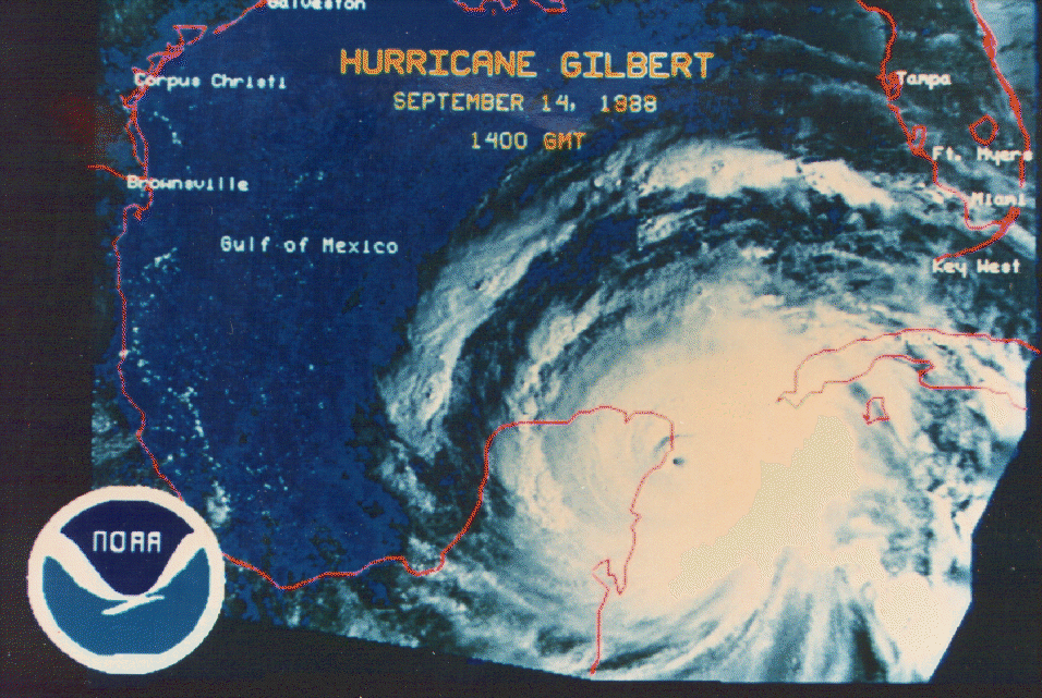
I think Gilbert was like that, though it gets compared a lot to Wilma. It was already a large Category 3 hurricane with a huge eye, but in the western Caribbean it redeveloped a pinhole eye.

Image

I think I read here that some gales were felt in the Florida Keys.

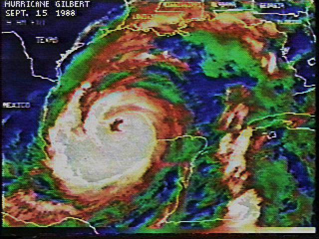
Image

Here it's covering most of the western GOM. (They don't have any advisories in the archives for Gilbert, so it's actual size at its peak is a mystery to me.)
0 likes   

Cyclone1
Category 5
Category 5
Posts: 2739
Age: 33
Joined: Tue Jun 12, 2007 12:03 pm
Location: Florida

#51 Postby Cyclone1 » Thu Mar 20, 2008 2:45 pm

In my opinion, Wilma has nothing on Gilbert except 6 or so millibars. Gilbert is still more impressive to me.
0 likes   

User avatar
Ptarmigan
Category 5
Category 5
Posts: 5313
Joined: Wed Aug 16, 2006 9:06 pm

Re:

#52 Postby Ptarmigan » Thu Mar 20, 2008 7:48 pm

Cyclone1 wrote:In my opinion, Wilma has nothing on Gilbert except 6 or so millibars. Gilbert is still more impressive to me.


Yeah, Gilbert was more impressive. Also, the fact is what got me into weather. In addition, it came close to hitting Texas. :eek: I wouldn't be surprised if Gilbert had a central pressure as low as 880 millibars.
Last edited by Ptarmigan on Thu Mar 20, 2008 7:52 pm, edited 1 time in total.
0 likes   

User avatar
Ptarmigan
Category 5
Category 5
Posts: 5313
Joined: Wed Aug 16, 2006 9:06 pm

Re: Re:

#53 Postby Ptarmigan » Thu Mar 20, 2008 7:51 pm

HurricaneRobert wrote:
Here it's covering most of the western GOM. (They don't have any advisories in the archives for Gilbert, so it's actual size at its peak is a mystery to me.)


Gilbert was at least 500 miles in diameter.
The massive storm system - Gilbert spanned 500 miles - continued to grow during the night and showed all signs of continuing to intensify with wind speed picking up as the storm barreled toward Mexico. It was expected to reach the area around Cancun and Cozumel early today, forecasters said.

http://www.chron.com/CDA/archives/archi ... 988_570095

Gale force winds in Gilbert extending at least 250 miles.
Tropical storm force winds extended 250 miles north from the storm center, and the hurricane was dumping 5 inches to 10 inches of rain along its path.

http://www.chron.com/CDA/archives/archi ... 988_570547

Gilbert was certainly larger than Katrina.
0 likes   

User avatar
wxman57
Moderator-Pro Met
Moderator-Pro Met
Posts: 22951
Age: 67
Joined: Sat Jun 21, 2003 8:06 pm
Location: Houston, TX (southwest)

Re: Re:

#54 Postby wxman57 » Fri Mar 21, 2008 1:06 pm

Ptarmigan wrote:
Derek Ortt wrote:A storm's wind field is small after rapid intensification. That is the only way the pressure gradient can allow such low pressures.

Uh, nope!

There have been many large TCs that underwent RI and remained as large TCs. The eye usually contracts (see Shapiro and Willoughby, 1982 for the physical mechanism that explains the contraction) during intensification, but the overall wind circulation does not necessarily contract


Hurricane Katrina comes to mind. In fact when it intensified, it grew.


Actually, when Katrina intensified from a Cat 2 at 7pm Saturday to a Cat 5 at 7am Sunday there was very little change in wind field size. The wind field expanded after Katrina reached Cat 5 and eyewall replacement cycles began.
0 likes   

User avatar
wxman57
Moderator-Pro Met
Moderator-Pro Met
Posts: 22951
Age: 67
Joined: Sat Jun 21, 2003 8:06 pm
Location: Houston, TX (southwest)

Re: Re:

#55 Postby wxman57 » Fri Mar 21, 2008 1:11 pm

Ptarmigan wrote:.... snip

Gilbert was certainly larger than Katrina.


Correct. I have wind radii data for both. Here are some averages for Gilbert vs. Katrina:

Katrina:
39 mph - 185 nautical miles
58 mph - 110 nautical miles
74 mph - 80 nautical miles

Gilbert:
39 mph - 240 nautical miles
58 mph - 175 nautical miles
74 mph - 115 nautical miles
0 likes   

User avatar
Ptarmigan
Category 5
Category 5
Posts: 5313
Joined: Wed Aug 16, 2006 9:06 pm

Re: Re:

#56 Postby Ptarmigan » Fri Mar 21, 2008 6:43 pm

wxman57 wrote:
Correct. I have wind radii data for both. Here are some averages for Gilbert vs. Katrina:

Katrina:
39 mph - 185 nautical miles
58 mph - 110 nautical miles
74 mph - 80 nautical miles

Gilbert:
39 mph - 240 nautical miles
58 mph - 175 nautical miles
74 mph - 115 nautical miles


Thanks! I wonder what the maximum extent was for Gilbert? I can't find any info on that.
0 likes   

MiamiensisWx

Re: Re:

#57 Postby MiamiensisWx » Fri Mar 21, 2008 6:52 pm

Ptarmigan wrote:Thanks! I wonder what the maximum extent was for Gilbert? I can't find any info on that.

This video is a treasure. It's the tropical update for September 14, 1988 when Gilbert struck the Yucatan Peninsula at Category 5 intensity. At the time of landfall, the intensity was 140 kt/900 mb, and it occurred some hours after its peak over the western Caribbean Sea. This is the closest clip to the tropical cyclone's peak intensity. In this old film, the storm was weakening as it moved inland. The great John Hope is featured here...

http://www.youtube.com/watch?v=GY-boNkNC2g

Note the wind radii graphic (2:46).

On another note, Gilbert was probably one of the stronger landfalling tropical cyclones of the 20th century.
0 likes   

User avatar
Ptarmigan
Category 5
Category 5
Posts: 5313
Joined: Wed Aug 16, 2006 9:06 pm

Re: Re:

#58 Postby Ptarmigan » Fri Mar 21, 2008 7:15 pm

MiamiensisWx wrote:This video is a treasure. It's the tropical update for September 14, 1988 when Gilbert struck the Yucatan Peninsula at Category 5 intensity. At the time of landfall, the intensity was 140 kt/900 mb, and it occurred some hours after its peak over the western Caribbean Sea. This is the closest clip to the tropical cyclone's peak intensity. In this old film, the storm was weakening as it moved inland. The great John Hope is featured here...

http://www.youtube.com/watch?v=GY-boNkNC2g

Note the wind radii graphic (2:46).

On another note, Gilbert was probably one of the stronger landfalling tropical cyclones of the 20th century.


I saw that video and even posted it here. I remember Gilbert well and it was a scary time.
0 likes   

CrazyC83
Professional-Met
Professional-Met
Posts: 34001
Joined: Tue Mar 07, 2006 11:57 pm
Location: Deep South, for the first time!

Re: Re:

#59 Postby CrazyC83 » Fri Mar 21, 2008 7:44 pm

Ptarmigan wrote:
Cyclone1 wrote:In my opinion, Wilma has nothing on Gilbert except 6 or so millibars. Gilbert is still more impressive to me.


Yeah, Gilbert was more impressive. Also, the fact is what got me into weather. In addition, it came close to hitting Texas. :eek: I wouldn't be surprised if Gilbert had a central pressure as low as 880 millibars.


My guess is 885mb, as the midpoint of different unconfirmed measurements plus the fact that it is listed at 888 in the best track followed by 889 - it is likely that Gilbert was still strengthening at the point of the 888.
0 likes   


Return to “Talkin' Tropics”

Who is online

Users browsing this forum: Google [Bot], Ulf and 95 guests