Well Defined Wave off African Coast

This is the general tropical discussion area. Anyone can take their shot at predicting a storms path.

Moderator: S2k Moderators

Forum rules

The posts in this forum are NOT official forecasts and should not be used as such. They are just the opinion of the poster and may or may not be backed by sound meteorological data. They are NOT endorsed by any professional institution or STORM2K. For official information, please refer to products from the National Hurricane Center and National Weather Service.

Help Support Storm2K
Message
Author
User avatar
cycloneye
Admin
Admin
Posts: 145285
Age: 68
Joined: Thu Oct 10, 2002 10:54 am
Location: San Juan, Puerto Rico

Re: Strong Wave inside Africa=Global Models show development

#41 Postby cycloneye » Sat Jul 19, 2008 2:26 pm

More pics:

Image

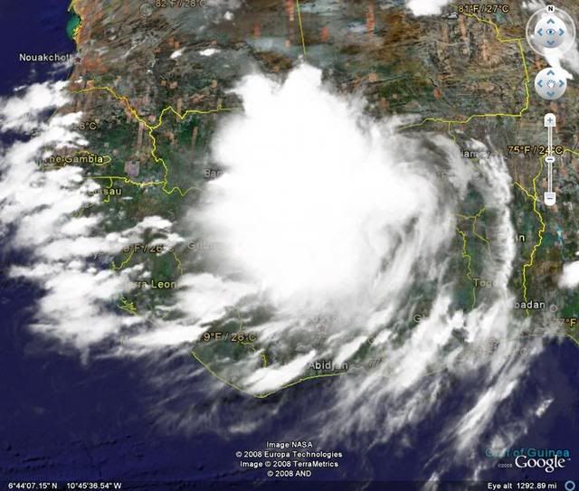
Half system below but you can see how big is the overall circulation.

Image
0 likes   

User avatar
blp
Category 5
Category 5
Posts: 2840
Age: 46
Joined: Thu Sep 09, 2004 7:51 pm
Location: Miami, FL
Contact:

Re: Strong Wave inside Africa=Global Models show development

#42 Postby blp » Sat Jul 19, 2008 2:28 pm

Check out the IR

18:45 UTC
Image

19:00 UTC
Image
Last edited by blp on Sat Jul 19, 2008 2:36 pm, edited 1 time in total.
0 likes   

Anthonyl
Tropical Depression
Tropical Depression
Posts: 97
Joined: Wed Apr 20, 2005 4:20 pm

Re: Strong Wave inside Africa=Global Models show development

#43 Postby Anthonyl » Sat Jul 19, 2008 2:34 pm

Is is same to assume that modles are initializing this system a little to much to the north, the rotation seem to be further south in the bulk of the convection. Also the ridge looks pretty stong at 1031 mbs. Any thoughts.
0 likes   

njweather
Tropical Storm
Tropical Storm
Posts: 169
Joined: Fri Aug 17, 2007 10:45 pm
Location: Washington, DC

Re: Strong Wave inside Africa=Global Models show development

#44 Postby njweather » Sat Jul 19, 2008 2:40 pm

Is it just me, or does this look like a tropical system right now?

I often wonder how amazing these storms must look from the ground as they cross over African savannas...
0 likes   

User avatar
blp
Category 5
Category 5
Posts: 2840
Age: 46
Joined: Thu Sep 09, 2004 7:51 pm
Location: Miami, FL
Contact:

Re: Strong Wave inside Africa=Global Models show development

#45 Postby blp » Sat Jul 19, 2008 2:56 pm

Seems like the EURO and GFS are handling the ridge differently. The EURO is breaking it down around 50W while the GFS is around 75W. Can't see yet what The EURO might be picking up on. I does not seem like a shortwave trough from the west will break down the ridge that much. I do see in the WV below an ULL developing around 26N & 50W and what might be a weak trough attached to Bertha. I would assume that with the High building back in from the east that would be long gone before the systems reaches that area. I think you are right we need to initialize this first before we know anything.

http://www.ssd.noaa.gov/goes/east/natl/loop-wv.html
0 likes   

User avatar
cycloneye
Admin
Admin
Posts: 145285
Age: 68
Joined: Thu Oct 10, 2002 10:54 am
Location: San Juan, Puerto Rico

Re: Strong Wave inside Africa=Global Models show development

#46 Postby cycloneye » Sat Jul 19, 2008 3:05 pm

:uarrow: The models iniciate a bit north in latitud than where really is the system.That may be very important in terms of getting a weakness or not.
0 likes   

bob rulz
Category 5
Category 5
Posts: 1704
Age: 35
Joined: Sat Jan 28, 2006 7:30 pm
Location: Salt Lake City, Utah

Re:

#47 Postby bob rulz » Sat Jul 19, 2008 3:29 pm

Aric Dunn wrote:its actually looks like a MCV!!! when that hits the water ( if it hold together) we should see something ..

that would be crazy if it develops and 94l develops .. that would make 4 names systems in july, I dont think that has happened has it..


There were 5 named storms in July in 2005. I believe that is the record.

Either way, this system indeed looks very impressive, but let's just wait until it gets over water to see what it does. Even the best-looking waves have a tendency to just dissolve as soon as they exit the coast.
0 likes   

User avatar
blp
Category 5
Category 5
Posts: 2840
Age: 46
Joined: Thu Sep 09, 2004 7:51 pm
Location: Miami, FL
Contact:

Re: Well Organized Wave inside Africa / Models develop it

#48 Postby blp » Sat Jul 19, 2008 3:33 pm

Yea I noticed that they seem to start off a bit North, but then they move it SW a little I guess in response to the building High. However, the EURO does not move it SW and moves it straight West at the higher latitude before recurve.
0 likes   

User avatar
KWT
Category 5
Category 5
Posts: 31415
Joined: Tue Aug 17, 2004 11:02 am
Location: UK!!!

#49 Postby KWT » Sat Jul 19, 2008 3:51 pm

Wow this look seriously good right now, indeed this may be an invest just 12-24hrs after exiting the coast, I also agree it looks even better then Bertha did at this stage, a pretty impressive feat!
0 likes   

User avatar
funster
Category 3
Category 3
Posts: 816
Joined: Sat Dec 29, 2007 4:27 pm
Location: North Dallas

#50 Postby funster » Sat Jul 19, 2008 4:31 pm

Wow. This July has been amazing to watch already.
0 likes   

User avatar
Gustywind
Category 5
Category 5
Posts: 12334
Joined: Mon Sep 03, 2007 7:29 am
Location: Baie-Mahault, GUADELOUPE

#51 Postby Gustywind » Sat Jul 19, 2008 5:00 pm

http://www.wunderground.com/blog/JeffMa ... amp=200807

Elsewhere in the tropics
Three of our four reliable computer models for are predicting a new tropical depression will develop off the coast of Africa 5-7 days from now. The level of tropical activity the past week has been quite remarkable, and is more typical of September than July. It's a very good thing that sea surface temperatures are more than 1°C cooler than during the record-breaking Hurricane Season of 2005. As it is, the nature of this unusually high early season activity likely means we are in for a busier than average main portion of hurricane season, August-October.

I'll have a full update Sunday morning, and perhaps a short update later today if we get a new named storm.

Jeff Masters
:roll: :eek: :?: .....
0 likes   

User avatar
KWT
Category 5
Category 5
Posts: 31415
Joined: Tue Aug 17, 2004 11:02 am
Location: UK!!!

#52 Postby KWT » Sat Jul 19, 2008 5:02 pm

The good thing is with this system expected to come off as far north as it will chances are pretty high that it will recurve at some point, still looks very good rightr now probably our next invest IMO.
0 likes   

User avatar
cycloneye
Admin
Admin
Posts: 145285
Age: 68
Joined: Thu Oct 10, 2002 10:54 am
Location: San Juan, Puerto Rico

Re: Well Organized Wave inside Africa / Models develop it

#53 Postby cycloneye » Sat Jul 19, 2008 5:25 pm

Pic at 21:00z or 5 PM EDT:

Image
0 likes   

User avatar
KWT
Category 5
Category 5
Posts: 31415
Joined: Tue Aug 17, 2004 11:02 am
Location: UK!!!

#54 Postby KWT » Sat Jul 19, 2008 5:31 pm

Wow thats looking pretty stunning right now cycloneye, wouldn't be surprise dif we have a TC again near 25W just like Bertha! :eek:
0 likes   

User avatar
HURAKAN
Professional-Met
Professional-Met
Posts: 46086
Age: 38
Joined: Thu May 20, 2004 4:34 pm
Location: Key West, FL
Contact:

#55 Postby HURAKAN » Sat Jul 19, 2008 5:34 pm

Image
0 likes   

User avatar
Extremeweatherguy
Category 5
Category 5
Posts: 11095
Joined: Mon Oct 10, 2005 8:13 pm
Location: Florida

Re:

#56 Postby Extremeweatherguy » Sat Jul 19, 2008 5:39 pm

KWT wrote:The good thing is with this system expected to come off as far north as it will chances are pretty high that it will recurve at some point, still looks very good rightr now probably our next invest IMO.
Yes, more often than not, a storm coming off Africa near the latitude of the Cape Verde islands will recurve. However, it should be noted that there have been many notable exceptions to this in years past...

1928 Hurricane - http://en.wikipedia.org/wiki/Image:1928 ... _track.png
1938 Hurricane - http://en.wikipedia.org/wiki/Image:1938 ... _track.png
1947 Hurricane - http://en.wikipedia.org/wiki/Image:1947 ... _track.png
Hurricane Hugo - http://en.wikipedia.org/wiki/Image:Hugo_1989_track.png
Hurricane Fran - http://en.wikipedia.org/wiki/Image:Fran_1996_track.png

For now, all we can really do with the current system is watch it and see how things evolve.
0 likes   

njweather
Tropical Storm
Tropical Storm
Posts: 169
Joined: Fri Aug 17, 2007 10:45 pm
Location: Washington, DC

Re: Well Organized Wave inside Africa / Models develop it

#57 Postby njweather » Sat Jul 19, 2008 5:40 pm

SAL is looking weaker than it was 24 hours ago. Possibly a trend?

24 hours ago:

Image

Latest:

Image
0 likes   

User avatar
Extremeweatherguy
Category 5
Category 5
Posts: 11095
Joined: Mon Oct 10, 2005 8:13 pm
Location: Florida

#58 Postby Extremeweatherguy » Sat Jul 19, 2008 5:40 pm

Cycloneye and Hurakan, thanks for the images! This system certainly is impressive-looking tonight.
0 likes   

User avatar
RattleMan
Category 5
Category 5
Posts: 1218
Joined: Wed Aug 24, 2005 7:14 pm
Location: Phoenix, AZ

Re:

#59 Postby RattleMan » Sat Jul 19, 2008 5:41 pm

HURAKAN wrote:http://i21.photobucket.com/albums/b300/HURAKAN5/97L.jpg

Getting ahead of the curve are we? :P
0 likes   

User avatar
KWT
Category 5
Category 5
Posts: 31415
Joined: Tue Aug 17, 2004 11:02 am
Location: UK!!!

#60 Postby KWT » Sat Jul 19, 2008 5:42 pm

Still those system really are the exception to the rule Extremeweatherguy. also yep SAL is decreasing as a weak wave comes offshore and helps to take the blow for the bigger wave behind.
0 likes   


Return to “Talkin' Tropics”

Who is online

Users browsing this forum: No registered users and 51 guests