Area East of 94L Looking Interesting=(Is invest 95L)

This is the general tropical discussion area. Anyone can take their shot at predicting a storms path.

Moderator: S2k Moderators

Forum rules

The posts in this forum are NOT official forecasts and should not be used as such. They are just the opinion of the poster and may or may not be backed by sound meteorological data. They are NOT endorsed by any professional institution or STORM2K. For official information, please refer to products from the National Hurricane Center and National Weather Service.

Help Support Storm2K
Message
Author
User avatar
SouthFloridawx
S2K Supporter
S2K Supporter
Posts: 8346
Age: 46
Joined: Tue Jul 26, 2005 1:16 am
Location: Sarasota, FL
Contact:

Re: Re:

#41 Postby SouthFloridawx » Thu Aug 21, 2008 12:30 am

Clipper96 wrote:
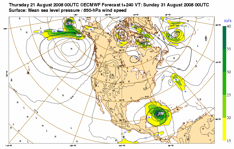
Scorpion wrote:Wow, it has a huge circulation. No wonder the Euro wants to make it the largest hurricane ever.
It wants to make it the largest, sloppiest tropical-storm ever, because it runs right over DR and Cuba just like Fay.


Holy crap on that one...
0 likes   

Wx_Warrior
Category 5
Category 5
Posts: 2718
Joined: Thu Aug 03, 2006 3:58 pm
Location: Beaumont, TX

Re: Area East of 94L Looking Interesting

#42 Postby Wx_Warrior » Thu Aug 21, 2008 2:22 am

wonder y gfs hasnt jumped on board?
0 likes   

Brent
S2K Supporter
S2K Supporter
Posts: 38088
Age: 36
Joined: Sun May 16, 2004 10:30 pm
Location: Tulsa Oklahoma
Contact:

Re: Area East of 94L Looking Interesting

#43 Postby Brent » Thu Aug 21, 2008 2:43 am

2nd run in a row! Looks even more intense this time, this is not a tropical storm, lol

Image
0 likes   

User avatar
KWT
Category 5
Category 5
Posts: 31415
Joined: Tue Aug 17, 2004 11:02 am
Location: UK!!!

#44 Postby KWT » Thu Aug 21, 2008 4:40 am

Very impressive ECM but what is it 94L or the ITCZ system behind it, because this run has it at Leeward islands at 72hrs, big ole system on the ECM it has to be said!
0 likes   

RL3AO
Moderator-Pro Met
Moderator-Pro Met
Posts: 16308
Joined: Thu Jun 14, 2007 10:03 pm
Location: NC

Re:

#45 Postby RL3AO » Thu Aug 21, 2008 4:47 am

KWT wrote:Very impressive ECM but what is it 94L or the ITCZ system behind it, because this run has it at Leeward islands at 72hrs, big ole system on the ECM it has to be said!


Its 94L. The area behind it would have to move 43kts to get there in 72 hours.
0 likes   

User avatar
KWT
Category 5
Category 5
Posts: 31415
Joined: Tue Aug 17, 2004 11:02 am
Location: UK!!!

#46 Postby KWT » Thu Aug 21, 2008 5:05 am

Yeah fair enough I thought so. Still this is a big system even if the ITCZ is enhancing it is looks like its got a chunky circulation thats well formed so this is looking odds on to get 95l sometime pretty soon IMO and I do think this one will also develop.
0 likes   

HURRICANELONNY
Category 5
Category 5
Posts: 1383
Joined: Wed May 07, 2003 6:48 am
Location: HOLLYWOOD.FL

Re: Area East of 94L Looking Interesting

#47 Postby HURRICANELONNY » Thu Aug 21, 2008 6:47 am

I'm amazed there is no invest on it. I guess because it's in the ITCZ. Will it crash into South America? Or will it head more wnw? :roll:
0 likes   

User avatar
Gustywind
Category 5
Category 5
Posts: 12334
Joined: Mon Sep 03, 2007 7:29 am
Location: Baie-Mahault, GUADELOUPE

#48 Postby Gustywind » Thu Aug 21, 2008 6:55 am

000
AXNT20 KNHC 210602
TWDAT

TROPICAL WEATHER DISCUSSION...
NWS TPC/NATIONAL HURRICANE CENTER MIAMI FL
205 AM EDT THU AUG 21 2008

TROPICAL WEATHER DISCUSSION FOR NORTH AMERICA...CENTRAL
AMERICA...GULF OF MEXICO...CARIBBEAN SEA...NORTHERN SECTIONS
OF SOUTH AMERICA...AND ATLANTIC OCEAN TO THE AFRICAN COAST
FROM THE EQUATOR TO 32N. THE FOLLOWING INFORMATION IS BASED
ON SATELLITE IMAGERY...METEOROLOGICAL ANALYSIS...WEATHER
OBSERVATIONS...AND RADAR.

BASED ON 0000 UTC SURFACE ANALYSIS AND SATELLITE IMAGERY THROUGH
0345 UTC.


...TROPICAL WAVES...
A NEW TROPICAL WAVE ALONG 29W/30W S OF 19N WITH A 1008 MB LOW
ALONG THE WAVE NEAR 11N WAS ADDED TO THE 0000Z SURFACE ANALYSIS
BASED ON SATELLITE IMAGERY...SURFACE OBSERVATIONS AND A QSCAT
PASS THAT SHOWS A WELL DEFINED WIND SHIFT ASSOCIATED WITH THE
WAVE AS WELL AS A BROAD CYCLONIC CIRCULATION ALONG THE WAVE AXIS
NEAR 11N. WAVE IS EMBEDDED WITHIN SOME DRY AIR...THUS NO
ASSOCIATED SHOWER ACTIVITY/CONVECTION.
0 likes   

User avatar
KWT
Category 5
Category 5
Posts: 31415
Joined: Tue Aug 17, 2004 11:02 am
Location: UK!!!

#49 Postby KWT » Thu Aug 21, 2008 6:55 am

Well the GFS has it on one of its crazy tracks, averages NW in the first 48hrs:

http://www.nco.ncep.noaa.gov/pmb/nwprod ... n_048m.gif

Though it starts this system too far north it seems.
0 likes   

User avatar
Gustywind
Category 5
Category 5
Posts: 12334
Joined: Mon Sep 03, 2007 7:29 am
Location: Baie-Mahault, GUADELOUPE

#50 Postby Gustywind » Thu Aug 21, 2008 6:56 am

Atlantic Tropical Weather Discussion
--------------------------------------------------------------------------------


000
AXNT20 KNHC 211151
TWDAT

TROPICAL WEATHER DISCUSSION...
NWS TPC/NATIONAL HURRICANE CENTER MIAMI FL
805 AM EDT THU AUG 21 2008

TROPICAL WEATHER DISCUSSION FOR NORTH AMERICA...CENTRAL
AMERICA...GULF OF MEXICO...CARIBBEAN SEA...NORTHERN SECTIONS
OF SOUTH AMERICA...AND ATLANTIC OCEAN TO THE AFRICAN COAST
FROM THE EQUATOR TO 32N. THE FOLLOWING INFORMATION IS BASED
ON SATELLITE IMAGERY...METEOROLOGICAL ANALYSIS...WEATHER
OBSERVATIONS...AND RADAR.

BASED ON 0600 UTC SURFACE ANALYSIS AND SATELLITE IMAGERY THROUGH
1015 UTC.

...TROPICAL WAVES...
TROPICAL WAVE IS ALONG 31W S OF 19N WITH A 1008 MB LOW ALONG THE
WAVE NEAR 12N MOVING W NEAR 10 KT. WAVE REMAINS EMBEDDED WITHIN
SOME RATHER DRY AIR BUT ISOLATED SHOWERS ARE FROM 13N-16N
BETWEEN 29W-31W.

:wink:
0 likes   

User avatar
cycloneye
Admin
Admin
Posts: 145290
Age: 68
Joined: Thu Oct 10, 2002 10:54 am
Location: San Juan, Puerto Rico

Re: Area East of 94L Looking Interesting

#51 Postby cycloneye » Thu Aug 21, 2008 7:16 am

Another interesting discussion from the San Juan NWS about whart is going on in the Tropical Atlantic:

MOISTURE FIELD PASSING ACROSS THE REGION THE PAST 24 HOURS...AND
ASSOCIATED WITH THE REMNANTS OF AN OLD NV...OR BAROCLINIC
LOW...PASSING W ACROSS THE CARIB S OF MONA PASSAGE ATTM...WITH
MIXED SAL EXPECTED TO SHIFT INTO THE AREA TODAY IN ITS WAKE...AND
AHEAD OF NEXT APPROACHING TROPICAL WAVE. SYNOPTIC PATTERN ACROSS
THE TROPICAL ATLC REMAINS VERY INTERESTING TODAY...WITH WELL
ESTABLISHED MONSOON TROUGH HAVING BROKEN FREE OF AFRICAN MONSOON
GYRE...THANKS TO A LARGE BAROCLINIC LOW HAVING MOVED ACROSS THE
CAPE VERDES PAST 24-36 HOURS...AND STRONG WLYS SOUTH OF TROUGH NOW
FLOWING SW TO NE AND INTO E SIDE OF THIS BROAD AND ELONGATED LOW.
A CLUSTER OF DEEP CNVTN AND MID LEVEL CYCLONIC TURNING CAN BE SEEN
ALONG ABOUT 9N 35W THIS MORNING ON S SIDE OF THIS EVOLVING
FEATURE. WLYS S OF THE MONSOON TROUGH NOW EXTEND FROM THE MID 50S
TO THIS LARGE TROPICAL WAVE CROSSING 30W THIS MORNING. TROPICAL
WAVE APPROACHING THE LESSER ANTILLES LOOKS TO BE ALONG 53/54W ATTM
AND GAINING POSITIVE TILT WITH TIME...AS MID LEVEL JET REMAINS
ALONG 18-20N. THIS ALIGNMENT CONTINUES TO BLEED VORTICITY AND
MOISTURE TO THE AMBIENT FLOW...WITH LEADING EDGE OF RELATED
MOISTURE JUST ABOUT TO REACH" onClick="return popup(this, 'notes')">REACH 60W ATTM. GFS NOT FORECASTING THIS
AREA OF WEATHER TO REACH THE USVI UNTIL 06-12Z FRIDAY...BUT SOME
LEADING MOISTURE LIKELY TO AFFECT THE LOCAL AREA TONIGHT. AS HAS
BEEN THE CASE ACROSS THE LOCAL REGION FOR MUCH OF THE PAST 30-60
DAYS...STEERING FLOW IS FORECAST TO GUIDE MUCH OF THE MOISTURE AND
ENERGY ASSOCIATED WITH THIS APPROACHING WAVE TO THE WNW AND
NW...AND LIFT N OF PUERTO RICO...JUST BRUSHING THE VIRGIN ISLANDS.
HOWEVER...CYCLONIC TURNING SEEN IN IR IMAGERY OVERNIGHT CENTERED
ALONG 12N 52W DOES NOT APPEAR WELL INITIALIZED BY GFS...AND THIS
MAY PASS JUST SOUTH OF PR FRI NIGHT-SAT TO IMPACT THE ISLAND MUCH
MORE SIGNIFICANTLY THAN CURRENTLY SUGGESTED. AGAIN...THIS COMPLEX
TROPICAL ENVIRONMENT ACROSS THE ATLC PROVING CHALLENGING FOR THE
GLOBAL MODELS AND THE NEXT WEEK AND BEYOND SHOULD BE INTERESTING.
MODELS WOULD SUGGEST THAT THE MID SUMMER DROUGHT HAS ENDED AND
MORE SIGNIFICANT RAINS ASSOCIATED WITH PASSING TROPICAL WAVES WILL
AFFECT THE REGION OVER THE NEXT WEEKS.

http://www.srh.noaa.gov/fwd/productview ... &version=0
0 likes   

User avatar
KWT
Category 5
Category 5
Posts: 31415
Joined: Tue Aug 17, 2004 11:02 am
Location: UK!!!

#52 Postby KWT » Thu Aug 21, 2008 7:37 am

Looking a little less impressive now that Dmax is past, still firing up convection well but clearly all involved in the ITCZ.
0 likes   

Derek Ortt

#53 Postby Derek Ortt » Thu Aug 21, 2008 7:42 am

I wouldn't touch a genesis forecast from the ECMWF

it seems to spin things up far more intense than does the Canadian
0 likes   

User avatar
KWT
Category 5
Category 5
Posts: 31415
Joined: Tue Aug 17, 2004 11:02 am
Location: UK!!!

#54 Postby KWT » Thu Aug 21, 2008 7:51 am

Hardly Derek in fact I've noticed it doesn't wind most systems up enough in the early phases of development, it may overdo it a touch when its formed a system depending on certain set-ups. Its far more likely to be too low than too high though.
0 likes   

User avatar
KWT
Category 5
Category 5
Posts: 31415
Joined: Tue Aug 17, 2004 11:02 am
Location: UK!!!

#55 Postby KWT » Thu Aug 21, 2008 5:35 pm

Convection flaring this time a touch further north, I do not know why on earth this isn't an invest right now!

http://www.ssd.noaa.gov/goes/east/catl/avn-l.jpg
0 likes   

User avatar
BigA
Professional-Met
Professional-Met
Posts: 1317
Joined: Sun Jul 24, 2005 10:56 pm

Re:

#56 Postby BigA » Thu Aug 21, 2008 5:53 pm

KWT wrote:Convection flaring this time a touch further north, I do not know why on earth this isn't an invest right now!

http://www.ssd.noaa.gov/goes/east/catl/avn-l.jpg


My best guess would be that those in charge of invest designation (is it the NHC?, NRL?) thinks that it is associated with the ITCZ still. In any case, its convective persistance has got 94L beat.
0 likes   

User avatar
abajan
S2K Supporter
S2K Supporter
Posts: 4230
Joined: Sun Sep 07, 2003 5:10 am
Location: Barbados

Re:

#57 Postby abajan » Thu Aug 21, 2008 7:18 pm

KWT wrote:Convection flaring this time a touch further north, I do not know why on earth this isn't an invest right now!

http://www.ssd.noaa.gov/goes/east/catl/avn-l.jpg
Invest or not, it certainly is a tropical disturbance. If memory serves me correctly, any area of thunderstorms in the tropics that maintain an identity for at least 24 hours is classified as a tropical disturbance. This has been around for much longer and I expect it to become an invest at anytime.
0 likes   

User avatar
AtlanticWind
S2K Supporter
S2K Supporter
Posts: 1888
Age: 66
Joined: Sun Aug 08, 2004 9:57 pm
Location: Plantation,Fla

Re: Re:

#58 Postby AtlanticWind » Thu Aug 21, 2008 7:53 pm

abajan wrote:
KWT wrote:Convection flaring this time a touch further north, I do not know why on earth this isn't an invest right now!

http://www.ssd.noaa.gov/goes/east/catl/avn-l.jpg
Invest or not, it certainly is a tropical disturbance. If memory serves me correctly, any area of thunderstorms in the tropics that maintain an identity for at least 24 hours is classified as a tropical disturbance. This has been around for much longer and I expect it to become an invest at anytime.

It is now an Invest 95L
0 likes   

User avatar
cycloneye
Admin
Admin
Posts: 145290
Age: 68
Joined: Thu Oct 10, 2002 10:54 am
Location: San Juan, Puerto Rico

Re: Area East of 94L Looking Interesting=(Is invest 95L)

#59 Postby cycloneye » Thu Aug 21, 2008 8:49 pm

The thread is locked as invest 95L is up for this system.Go to Active Storms Forum for all the information about the new invest.
0 likes   


Return to “Talkin' Tropics”

Who is online

Users browsing this forum: Google [Bot], Hurricane2000, hurricanes1234, Killjoy12, Ulf, USTropics and 54 guests