Weak Surface Low in Western GOM - Yellow-20% (Is 94L)
Moderator: S2k Moderators
Forum rules

The posts in this forum are NOT official forecasts and should not be used as such. They are just the opinion of the poster and may or may not be backed by sound meteorological data. They are NOT endorsed by any professional institution or STORM2K. For official information, please refer to products from the National Hurricane Center and National Weather Service.
-
floridasun78
- Category 5

- Posts: 3755
- Joined: Sun May 17, 2009 10:16 pm
- Location: miami fl
-
wxman57

- Moderator-Pro Met

- Posts: 23175
- Age: 68
- Joined: Sat Jun 21, 2003 8:06 pm
- Location: Houston, TX (southwest)
Re: Broad Trough=Yucatan / NW Carib / E GOM - Yellow-10%
I notice that NHC has switched their discussion from one disturbance (Bay of Campeche) to the other (western Caribbean) in the past few outlooks. The first disturbance should zip up the front and into the mid Gulf coast tomorrow. The second in the BoC might be a development risk by Sat PM/Sun as it moves northward into the NW Gulf.
Most likely, neither disturbance will develop. Perhaps some much-needed rainfall for SE TX this weekend.
Most likely, neither disturbance will develop. Perhaps some much-needed rainfall for SE TX this weekend.
0 likes
-
lrak

- S2K Supporter

- Posts: 1770
- Age: 59
- Joined: Thu Jun 21, 2007 2:48 pm
- Location: Corpus Christi, TX
Re: Broad Trough=Yucatan / NW Carib / E GOM - Yellow-10%
wxman57 wrote:I notice that NHC has switched their discussion from one disturbance (Bay of Campeche) to the other (western Caribbean) in the past few outlooks. The first disturbance should zip up the front and into the mid Gulf coast tomorrow. The second in the BoC might be a development risk by Sat PM/Sun as it moves northward into the NW Gulf.
Most likely, neither disturbance will develop. Perhaps some much-needed rainfall for SE TX this weekend.
Any hope for deep S. Tex Sir? Maybe a little swell action as well?
0 likes
AKA karl
Also
Personal Forecast Disclaimer:
My posts on this forum are NOT official forecast and should not be used as such. My posts are my basic observations and are definitely not backed by any "well some" meteorological knowledge. For official information, please refer to the NHC and NWS products.
Also
Personal Forecast Disclaimer:
My posts on this forum are NOT official forecast and should not be used as such. My posts are my basic observations and are definitely not backed by any "well some" meteorological knowledge. For official information, please refer to the NHC and NWS products.
-
vbhoutex

- Storm2k Executive

- Posts: 29150
- Age: 74
- Joined: Wed Oct 09, 2002 11:31 pm
- Location: Cypress, TX
- Contact:
Re: Broad Trough=Yucatan / NW Carib / E GOM - Yellow-10%
wxman57 wrote:I notice that NHC has switched their discussion from one disturbance (Bay of Campeche) to the other (western Caribbean) in the past few outlooks. The first disturbance should zip up the front and into the mid Gulf coast tomorrow. The second in the BoC might be a development risk by Sat PM/Sun as it moves northward into the NW Gulf.
Most likely, neither disturbance will develop. Perhaps some much-needed rainfall for SE TX this weekend.
Why the thought that we will have rain from this? At this point I don't see anything indicating that the stuff in the BOC will come N or NW and it appears the system in the E GOM is destined to go north at least in the short term. Please tell me what I am missing as I know I am missing something besides what the models are saying.
0 likes
Skywarn, C.E.R.T.
Please click below to donate to STORM2K to help with the expenses of keeping the site going:

Please click below to donate to STORM2K to help with the expenses of keeping the site going:


Re: Broad Trough=Yucatan / NW Carib / E GOM - Yellow-10%
vbhoutex wrote:Why the thought that we will have rain from this? At this point I don't see anything indicating that the stuff in the BOC will come N or NW and it appears the system in the E GOM is destined to go north at least in the short term. Please tell me what I am missing as I know I am missing something besides what the models are saying.
Bermuda high split and retrogrades. Everything gets shunted around it so the eastern gulf clears while the mass shifts to the western gulf. Assuming whatever down there gets going at all.
0 likes
The above post and any post by Ntxw is NOT an official forecast and should not be used as such. It is just the opinion of the poster and may or may not be backed by sound meteorological data. It is NOT endorsed by any professional institution including Storm2k. For official information, please refer to NWS products.
Help support Storm2K!
-
Extratropical94

- Professional-Met

- Posts: 3545
- Age: 31
- Joined: Wed Oct 20, 2010 6:36 am
- Location: Hamburg, Germany
- Contact:
10%
CLOUDINESS AND SHOWERS EXTENDING FROM THE YUCATAN PENINSULA
NORTH-NORTHEASTWARD ACROSS THE EASTERN GULF OF MEXICO ARE
ASSOCIATED WITH A BROAD TROUGH OF LOW PRESSURE. UPPER-LEVEL WINDS
ARE NOT EXPECTED TO BE CONDUCIVE FOR SIGNIFICANT DEVELOPMENT DURING
THE NEXT COUPLE OF DAYS WHILE THE DISTURBANCE MOVES GENERALLY
WESTWARD TOWARD THE WESTERN GULF OF MEXICO. THIS SYSTEM HAS A LOW
CHANCE...10 PERCENT...OF BECOMING A TROPICAL CYCLONE DURING THE
NEXT 48 HOURS. REGARDLESS OF DEVELOPMENT...HEAVY RAINS ASSOCIATED
WITH THE SYSTEM COULD PRODUCE FLOODING ACROSS PORTIONS OF THE
SOUTHEASTERN UNITED STATES DURING THE NEXT COUPLE OF DAYS.
0 likes
54° 11' 59'' N, 9° 9' 20'' E
Boomer Sooner!
Go Broncos! Go Cards!
Clinching counties, one at a time: https://mob-rule.com/user-gifs/USA/xtrp94.gif
- Daniel
Boomer Sooner!
Go Broncos! Go Cards!
Clinching counties, one at a time: https://mob-rule.com/user-gifs/USA/xtrp94.gif
- Daniel

Re: Broad Trough=Yucatan / NW Carib / E GOM - Yellow-10%
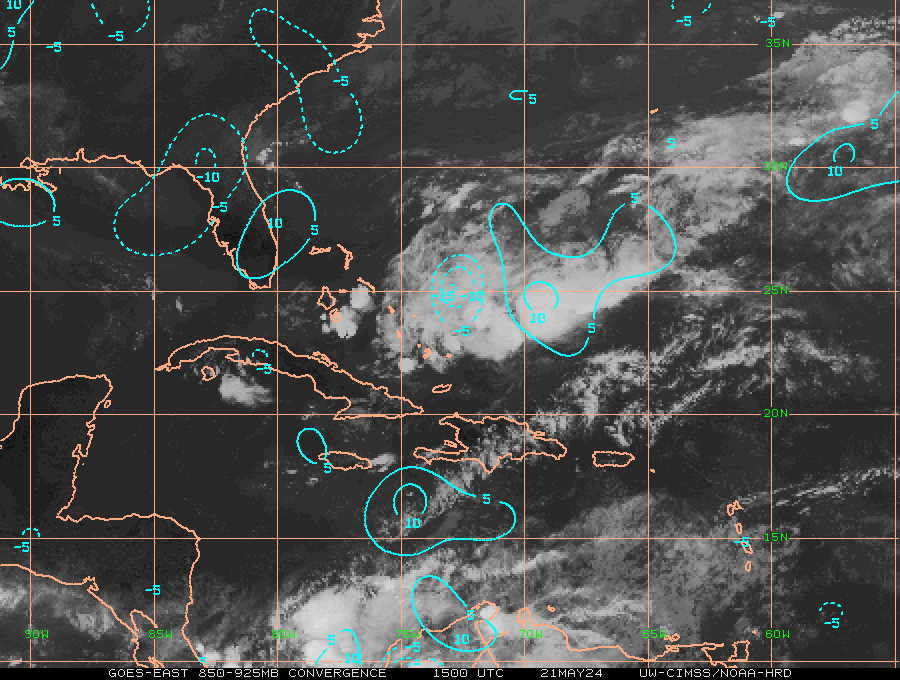
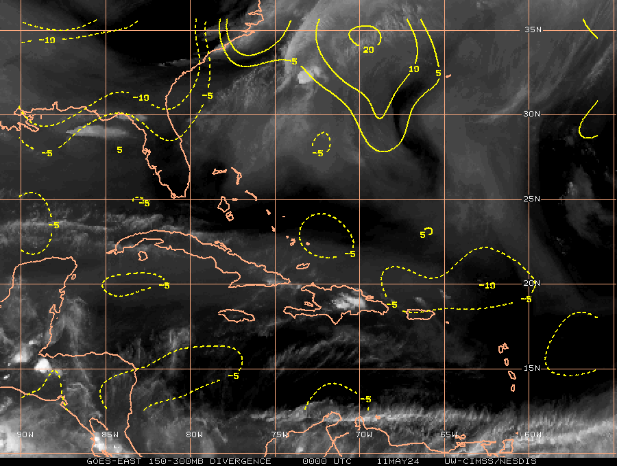
This wave/trough, North of the Yucatan channel looks like it's starting to get it's act together...............abiet the shear. Buoy 40023 has 25 knot winds ATM, pressures aren't dropping yet but I think they will soon if the convection continues.
850 vorticy

convergence
Divergence
850 vorticy
convergence
Divergence
0 likes
The following post is NOT an official forecast and should not be used as such. It is just the opinion of the poster and may or may not be backed by sound meteorological data. It is NOT endorsed by any professional institution including storm2k.org For Official Information please refer to the NHC and NWS products.

-
Rgv20

- S2K Supporter
- Posts: 2466
- Age: 39
- Joined: Wed Jan 05, 2011 5:42 pm
- Location: Edinburg/McAllen Tx
Things are sure looking interesting in the near future..
21zSREF Ensemble 48hrs forecast for Tropical Cyclone Development..
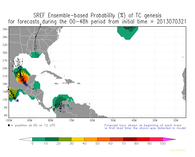
21zSREF Ensemble 48hrs forecast for Tropical Cyclone Development..

0 likes
The following post is NOT an official forecast and should not be used as such. It is just the opinion of the poster and may or may not be backed by sound meteorological data. It is NOT endorsed by any professional institution including storm2k.org For Official Information please refer to the NHC and NWS products.
-
HouTXmetro

- Category 5
- Posts: 3949
- Joined: Sun Jun 13, 2004 6:00 pm
- Location: District of Columbia, USA
-
cycloneye

- Admin
- Posts: 149720
- Age: 69
- Joined: Thu Oct 10, 2002 10:54 am
- Location: San Juan, Puerto Rico
Re: Broad Trough=Yucatan / NW Carib / E GOM - Yellow-10%
Remains at 10%.
TROPICAL WEATHER OUTLOOK
NWS NATIONAL HURRICANE CENTER MIAMI FL
800 AM EDT THU JUL 4 2013
FOR THE NORTH ATLANTIC...CARIBBEAN SEA AND THE GULF OF MEXICO...
CLOUDINESS AND SHOWERS EXTENDING FROM THE YUCATAN PENINSULA
NORTH-NORTHEASTWARD ACROSS THE EASTERN GULF OF MEXICO TO THE FLORIDA
PANHANDLE ARE ASSOCIATED WITH A BROAD TROUGH OF LOW PRESSURE.
UPPER-LEVEL WINDS ARE NOT EXPECTED TO BE CONDUCIVE FOR SIGNIFICANT
DEVELOPMENT DURING THE NEXT COUPLE OF DAYS WHILE THE DISTURBANCE
MOVES SLOWLY WESTWARD OR WEST-NORTHWESTWARD TOWARD THE WESTERN GULF
OF MEXICO. THIS SYSTEM HAS A LOW CHANCE...10 PERCENT...OF BECOMING
A TROPICAL CYCLONE DURING THE NEXT 48 HOURS. REGARDLESS OF
DEVELOPMENT...HEAVY RAINS ASSOCIATED WITH THE DISTURBANCE COULD
PRODUCE FLOODING ACROSS PORTIONS OF THE SOUTHEASTERN UNITED STATES
DURING THE NEXT COUPLE OF DAYS.
ELSEWHERE...TROPICAL CYCLONE FORMATION IS NOT EXPECTED DURING THE
NEXT 48 HOURS.
$$
FORECASTER BROWN
0 likes
Visit the Caribbean-Central America Weather Thread where you can find at first post web cams,radars
and observations from Caribbean basin members Click Here
and observations from Caribbean basin members Click Here

-
wxman57
- Moderator-Pro Met
- Posts: 23175
- Age: 68
- Joined: Sat Jun 21, 2003 8:06 pm
- Location: Houston, TX (southwest)
Re: Broad Trough=YUCATAN / BOC / E GOM - Yellow-10%
I can't find any predicted low in the 00Z Canadian run. GFS has a 1010mb low moving into SW LA on Sunday afternoon. NHC's 10% area was another feature. 10% is VERY generous given the high shear across the central and eastern Gulf. Development chances through 48 hrs about 0.00000001%. Just some rain for the Gulf Coast along/ahead of that weak frontal boundary. With luck, the other feature will move out of the BoC tomorrow and possibly bring some rain to SE TX.
0 likes
The first weak low pressure is pushing onshore near Pensacola, clearly seen on surface reports the weak circulation, the high shear is pushing everything eastward from the weak surface low.

The weak surface low has a pressure of near 1013mb, because of the pressure gradient, with Jacksonville reporting a pressure of 1021mb, fairly strong winds are being reported on the east side of the low pressure gusting close to tropical force winds.
Conditions at: KAAF observed 04 July 2013 14:09 UTC
Temperature: 24.0°C (75°F)
Dewpoint: 22.0°C (72°F) [RH = 89%]
Pressure (altimeter): 30.06 inches Hg (1018.0 mb)
Winds: from the S (170 degrees) at 26 MPH (23 knots; 12.0 m/s)
gusting to 36 MPH (31 knots; 16.1 m/s)
Visibility: 1.00 miles (1.61 km)
Ceiling: 3100 feet AGL
Clouds: few clouds at 1200 feet AGL
scattered clouds at 2300 feet AGL
overcast cloud deck at 3100 feet AGL
Present Weather: +RA BR (heavy rain, mist)
SOME DATA ABOVE MAY BE INACCURATE!!!
"$" is an indication the sensor requires maintenance
0 likes
I think the second feature coming out of the Yucatan Peninsula may have a chance at development if it gets a break from the shear.
The GFS is still fairly persistent in building a ridge close to the surface vorticity on Sunday and get located between two upper level lows creating an excellent outflow, if this happens the second system may have a chance to develop further before making landfall in the upper TX or LA coast, but as we know upper level conditions are very hard to forecast by models past a 48hr period so it may not happen at all. Something to watch out for right now.
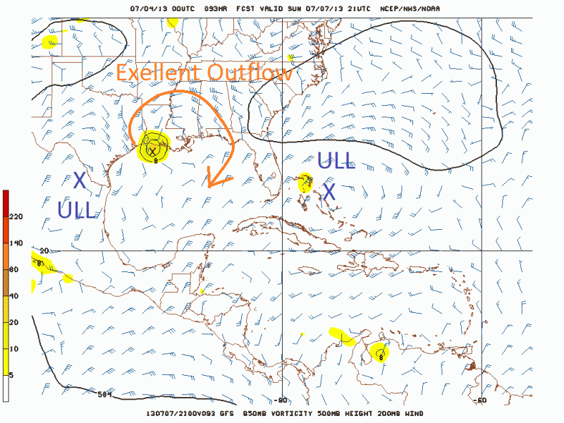
The GFS is still fairly persistent in building a ridge close to the surface vorticity on Sunday and get located between two upper level lows creating an excellent outflow, if this happens the second system may have a chance to develop further before making landfall in the upper TX or LA coast, but as we know upper level conditions are very hard to forecast by models past a 48hr period so it may not happen at all. Something to watch out for right now.
0 likes
-
Dean4Storms
- S2K Supporter
- Posts: 6358
- Age: 63
- Joined: Sun Aug 31, 2003 1:01 pm
- Location: Miramar Bch. FL
-
tolakram
- Admin
- Posts: 20186
- Age: 62
- Joined: Sun Aug 27, 2006 8:23 pm
- Location: Florence, KY (name is Mark)
Re: Broad Trough=YUCATAN / BOC / E GOM - Yellow-10%
Gulf flow all the way up to Ohio, feels like we're on the beach up here. Flash flood watches from Gulf Shores all the way north to central Ohio. IMO This giant system has to clear out of here before any Gulf development is possible.

live visible loop: http://wwwghcc.msfc.nasa.gov/cgi-bin/ge ... umframes=5
live visible loop: http://wwwghcc.msfc.nasa.gov/cgi-bin/ge ... umframes=5
0 likes
M a r k
- - - - -
Join us in chat: Storm2K Chatroom Invite. Android and IOS apps also available.
The posts in this forum are NOT official forecasts and should not be used as such. Posts are NOT endorsed by any professional institution or STORM2K.org. For official information and forecasts, please refer to NHC and NWS products.

Re: Broad Trough=YUCATAN / BOC / E GOM - Yellow-10%
tolakram wrote:Gulf flow all the way up to Ohio, feels like we're on the beach up here. Flash flood watches from Gulf Shores all the way north to central Ohio. IMO This giant system has to clear out of here before any Gulf development is possible.
http://imageshack.us/a/img69/183/db54.jpg
live visible loop: http://wwwghcc.msfc.nasa.gov/cgi-bin/ge ... umframes=5
Tolakram, how long do you see this current system hanging around before it clears out? Is it going to move more to the west, north, or east before clearing out? Thanks in advance.
0 likes
Who is online
Users browsing this forum: No registered users and 141 guests