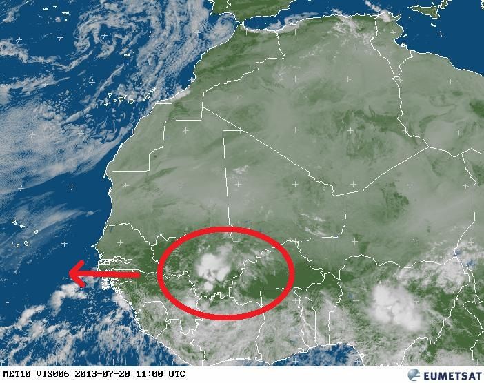
Tropical Wave (Pouch 12L) E Atlantic - (Is Invest 98L)

This is the general tropical discussion area. Anyone can take their shot at predicting a storms path.

Moderator: S2k Moderators

Forum rules

The posts in this forum are NOT official forecasts and should not be used as such. They are just the opinion of the poster and may or may not be backed by sound meteorological data. They are NOT endorsed by any professional institution or STORM2K. For official information, please refer to products from the National Hurricane Center and National Weather Service.

Help Support Storm2K
Message
Author
User avatar
NDG
S2K Supporter
S2K Supporter
Posts: 15444
Joined: Sun Jul 09, 2006 10:14 pm
Location: Orlando, FL

Re: African "bear watch": E Atlantic development?

#41 Postby NDG » Sat Jul 20, 2013 7:59 am

cycloneye wrote:
NDG wrote:Here is the tropical wave in Africa that the GFS and Canadian models develop in a few days south or SW of the CV Islands.

http://i20.photobucket.com/albums/b245/ ... e4de12.jpg


The cluster behind looks better than what you circled. IMO,that one may be it.


At first I thought so also, but when you watch the GFS link below it clearly shows the tropical wave that I circled being the one that starts developing and or getting better organized as early as Tuesday south of the CV Islands, the other tropical wave that you mentioned by then it is still well inland in Africa.

Loop this link
0 likes   

User avatar
cycloneye
Admin
Admin
Posts: 143863
Age: 68
Joined: Thu Oct 10, 2002 10:54 am
Location: San Juan, Puerto Rico

Re: African "bear watch": E Atlantic development?

#42 Postby cycloneye » Sat Jul 20, 2013 9:51 am

What Dr Jeff Masters said this Saturday morning about this.

Saturday morning's 06Z run of the GFS model predicted that a tropical wave expected to move off the coast of Africa on Monday will develop later in the week. None of the other reliable models develop this wave, though the unreliable Canadian (CMC) model also suggests that the wave could develop.
0 likes   
Visit the Caribbean-Central America Weather Thread where you can find at first post web cams,radars
and observations from Caribbean basin members Click Here

HurricaneTracker2031
Tropical Storm
Tropical Storm
Posts: 248
Age: 25
Joined: Fri Jul 19, 2013 7:20 pm
Location: Pembroke Pines, FL, USA
Contact:

#43 Postby HurricaneTracker2031 » Sat Jul 20, 2013 10:36 am

:uarrow: I see that thee GFS is showing a possible system next week (06z)
0 likes   
SHORT VERSION OF DISCLAIMER: THIS SITE LINK BELOW IS NOT AN OFFICIAL FORECASTING OFFICE AND SHOULD NOT BE USED TO MAKE ANY EMERGENCY DECISIONS....

http://www.macstropicalweather.weebly.com

User avatar
Hurricaneman
Category 5
Category 5
Posts: 7349
Age: 44
Joined: Tue Aug 31, 2004 3:24 pm
Location: central florida

Re: African "bear watch": E Atlantic development?

#44 Postby Hurricaneman » Sat Jul 20, 2013 10:46 am

Looks like the 12zGFS shows some development of this by Monday morning

The posts in this forum are NOT official forecast and should not be used as such. They are just the opinion of the poster and may or may not be backed by sound meteorological data. They are NOT endorsed by any professional institution or storm2k.org. For official information, please refer to the NHC and NWS products
0 likes   

User avatar
cycloneye
Admin
Admin
Posts: 143863
Age: 68
Joined: Thu Oct 10, 2002 10:54 am
Location: San Juan, Puerto Rico

Re: African "bear watch": E Atlantic development?

#45 Postby cycloneye » Sat Jul 20, 2013 10:53 am

Maybe a little overdone but here is 12z GFS at 66 hours.I will put the timeframes in this post to not make one post for every hour. :D

Image

90 hours.

Image

120 hours.

Image

132 hours.

Image

138 hours.

Image

162 hours.

Image

174 hours.

Image

192 hours. Over Puerto Rico,yeah :roll:

Image
0 likes   
Visit the Caribbean-Central America Weather Thread where you can find at first post web cams,radars
and observations from Caribbean basin members Click Here

Alyono
Professional-Met
Professional-Met
Posts: 6961
Joined: Fri Apr 26, 2013 3:52 pm
Location: Texas Coast

#46 Postby Alyono » Sat Jul 20, 2013 11:36 am

smacks right into Hispañiola this run
0 likes   

User avatar
cycloneye
Admin
Admin
Posts: 143863
Age: 68
Joined: Thu Oct 10, 2002 10:54 am
Location: San Juan, Puerto Rico

Re: African "bear watch": E Atlantic development? (Models here)

#47 Postby cycloneye » Sat Jul 20, 2013 11:38 am

:uarrow: Ok folks,that is it for me until 192 hours. Hispaniola pretty much kills it this run.
0 likes   
Visit the Caribbean-Central America Weather Thread where you can find at first post web cams,radars
and observations from Caribbean basin members Click Here

User avatar
Ivanhater
Storm2k Moderator
Storm2k Moderator
Posts: 11153
Age: 38
Joined: Fri Jul 01, 2005 8:25 am
Location: Pensacola

Re: African "bear watch": E Atlantic development? (Models here)

#48 Postby Ivanhater » Sat Jul 20, 2013 11:40 am

cycloneye wrote::uarrow: Ok folks,that is it for me until 192 hours. Hispaniola pretty much kills it this run.


Nope, ends up in the Gulf
0 likes   
Michael

User avatar
cycloneye
Admin
Admin
Posts: 143863
Age: 68
Joined: Thu Oct 10, 2002 10:54 am
Location: San Juan, Puerto Rico

Re: African "bear watch": E Atlantic development? (Models here)

#49 Postby cycloneye » Sat Jul 20, 2013 11:41 am

Ivanhater wrote:
cycloneye wrote::uarrow: Ok folks,that is it for me until 192 hours. Hispaniola pretty much kills it this run.


Nope, ends up in the Gulf


Yeah,I saw the long range and comes alive again.
0 likes   
Visit the Caribbean-Central America Weather Thread where you can find at first post web cams,radars
and observations from Caribbean basin members Click Here

User avatar
'CaneFreak
Category 5
Category 5
Posts: 1486
Joined: Mon Jun 05, 2006 10:50 am
Location: New Bern, NC

#50 Postby 'CaneFreak » Sat Jul 20, 2013 11:43 am

If there were any questions about the potential strength of the ridging in the West Atlantic late in the period, those were answered in this run...sheesh :roll:
0 likes   

Alyono
Professional-Met
Professional-Met
Posts: 6961
Joined: Fri Apr 26, 2013 3:52 pm
Location: Texas Coast

#51 Postby Alyono » Sat Jul 20, 2013 11:48 am

flipped from New England to the US/Mexico Border
0 likes   

User avatar
gatorcane
S2K Supporter
S2K Supporter
Posts: 23689
Age: 47
Joined: Sun Mar 13, 2005 3:54 pm
Location: Boca Raton, FL

#52 Postby gatorcane » Sat Jul 20, 2013 11:48 am

How about how the 12Z shows a completely different long-wave pattern over the subtropical northern Atlantic and North America this run sending this system very far west through the Caribbean islands and then into the Gulf.

The 00Z CMC also shows this system getting far west also. The 12Z CMC is rolling so let's see what it does with this.

MiamiensisWx - good call on creating this thread several days ago. it certainly seems like a system may be materializing especially since the GFS shows the low near the Cape Verde islands in only a few days from now.
0 likes   

Stormlover2012
Category 1
Category 1
Posts: 262
Joined: Sat Jun 23, 2012 11:03 am

Global Model Runs Discussion

#53 Postby Stormlover2012 » Sat Jul 20, 2013 11:55 am

Gfs has south texas/Mexico lol
0 likes   

User avatar
gatorcane
S2K Supporter
S2K Supporter
Posts: 23689
Age: 47
Joined: Sun Mar 13, 2005 3:54 pm
Location: Boca Raton, FL

#54 Postby gatorcane » Sat Jul 20, 2013 12:00 pm

12Z CMC shows the low but not nearly as bullish as the 00Z CMC or 12Z GFS. Here we are at 138 hours from now with a sharp wave signature shown east of the islands. Let's see what the rest of the run does with this wave:

Image
0 likes   

User avatar
cycloneye
Admin
Admin
Posts: 143863
Age: 68
Joined: Thu Oct 10, 2002 10:54 am
Location: San Juan, Puerto Rico

Re: African "bear watch": E Atlantic development? (Models here)

#55 Postby cycloneye » Sat Jul 20, 2013 12:06 pm

Here is what Dr Masters said about CMC-GEM.

Saturday morning's 06Z run of the GFS model predicted that a tropical wave expected to move off the coast of Africa on Monday will develop later in the week. None of the other reliable models develop this wave, though the unreliable Canadian (CMC) model also suggests that the wave could develop.
0 likes   
Visit the Caribbean-Central America Weather Thread where you can find at first post web cams,radars
and observations from Caribbean basin members Click Here

User avatar
gatorcane
S2K Supporter
S2K Supporter
Posts: 23689
Age: 47
Joined: Sun Mar 13, 2005 3:54 pm
Location: Boca Raton, FL

#56 Postby gatorcane » Sat Jul 20, 2013 12:16 pm

12Z CMC shows the African wave as a weak low passing through NE Leewards:

Image
Last edited by gatorcane on Sat Jul 20, 2013 12:18 pm, edited 2 times in total.
0 likes   

Alyono
Professional-Met
Professional-Met
Posts: 6961
Joined: Fri Apr 26, 2013 3:52 pm
Location: Texas Coast

#57 Postby Alyono » Sat Jul 20, 2013 12:16 pm

12Z CMC shows nothing

I wonder if the GFS is having parameterization issues. Something this close to developing should also be seen by the CMC if it were real.
0 likes   

User avatar
gatorcane
S2K Supporter
S2K Supporter
Posts: 23689
Age: 47
Joined: Sun Mar 13, 2005 3:54 pm
Location: Boca Raton, FL

Re:

#58 Postby gatorcane » Sat Jul 20, 2013 12:17 pm

Alyono wrote:12Z CMC shows nothing

I wonder if the GFS is having parameterization issues. Something this close to developing should also be seen by the CMC if it were real.


Not exactly nothing, there is a weak low there / strong tropical wave but not nearly as organized as the GFS shows.
0 likes   

Alyono
Professional-Met
Professional-Met
Posts: 6961
Joined: Fri Apr 26, 2013 3:52 pm
Location: Texas Coast

#59 Postby Alyono » Sat Jul 20, 2013 12:18 pm

I'd say Masters needs to look at the GFS skill as of late before calling it a reliable model.

It has been developing several CV systems this month. Of course, none formed. The one that formed was NOT forecast to develop by the GFS
0 likes   

User avatar
Riptide
Category 2
Category 2
Posts: 753
Age: 33
Joined: Fri Jul 23, 2010 3:33 pm
Location: Cape May, New Jersey
Contact:

Re:

#60 Postby Riptide » Sat Jul 20, 2013 12:28 pm

Alyono wrote:I'd say Masters needs to look at the GFS skill as of late before calling it a reliable model.

It has been developing several CV systems this month. Of course, none formed. The one that formed was NOT forecast to develop by the GFS

I don't recall as much development, GFS has not showed a classic long-tracking Cape Verde TC since last year and Chantal surprised the euro. It's the only game in town and appears to have modest possibilities.
0 likes   


Return to “Talkin' Tropics”

Who is online

Users browsing this forum: Ulf and 91 guests