Tropical Wave in NW Caribbean/Yucatan (Is Invest 95L)

This is the general tropical discussion area. Anyone can take their shot at predicting a storms path.

Moderator: S2k Moderators

Forum rules

The posts in this forum are NOT official forecasts and should not be used as such. They are just the opinion of the poster and may or may not be backed by sound meteorological data. They are NOT endorsed by any professional institution or STORM2K. For official information, please refer to products from the National Hurricane Center and National Weather Service.

Help Support Storm2K
Message
Author
User avatar
gatorcane
S2K Supporter
S2K Supporter
Posts: 23499
Age: 46
Joined: Sun Mar 13, 2005 3:54 pm
Location: Boca Raton, FL

#41 Postby gatorcane » Sun Aug 11, 2013 1:16 pm

The 12Z UKMET back on Thu. depicted this broad area of low pressure quite well.

Saved image from that run below:

Image
0 likes   

User avatar
cycloneye
Admin
Admin
Posts: 139593
Age: 67
Joined: Thu Oct 10, 2002 10:54 am
Location: San Juan, Puerto Rico

Re: Tropical Wave / Pouch 20L in East Atlantic

#42 Postby cycloneye » Sun Aug 11, 2013 6:52 pm

8 PM Discussion.

TROPICAL WAVE EXTENDS FROM 20N25W TO 13N27W MOVING W AT 15 KT.
THE BASE OF THE WAVE HAS AN EMBEDDED 1010 MB LOW AT 13N27W. SSMI
TOTAL PRECIPITABLE WATER IMAGERY INDICATES MAXIMUM VALUES FROM
08N-22N BETWEEN 15W-26W. CONVECTION REMAINS LARGELY EMBEDDED
WITHIN THE MONSOON TROUGH AXIS WITH SCATTERED MODERATE FROM 6N-
22N BETWEEN 13W-30W TO INCLUDE THE CAPE VERDE ISLANDS. SCATTERED
SHOWERS ARE WITHIN 180 NM OF THE TROUGH AXIS.
0 likes   
Visit the Caribbean-Central America Weather Thread where you can find at first post web cams,radars
and observations from Caribbean basin members Click Here

User avatar
cycloneye
Admin
Admin
Posts: 139593
Age: 67
Joined: Thu Oct 10, 2002 10:54 am
Location: San Juan, Puerto Rico

Re: Tropical Wave / Pouch 20L in East Atlantic

#43 Postby cycloneye » Sun Aug 11, 2013 10:51 pm

Wave has maintained the circulation for more than 24 hours as you saw in last nights pass but convection is not plenty at this time. Tonight's OSCAT pass was made at 9:40 PM EDT.

Image
0 likes   
Visit the Caribbean-Central America Weather Thread where you can find at first post web cams,radars
and observations from Caribbean basin members Click Here

User avatar
Hurricaneman
Category 5
Category 5
Posts: 7284
Age: 43
Joined: Tue Aug 31, 2004 3:24 pm
Location: central florida

Re: Tropical Wave / Pouch 20L in East Atlantic

#44 Postby Hurricaneman » Sun Aug 11, 2013 11:25 pm

with the current organization trend I would not be surprised if they 10% lemon it tomorrow morning

as for further development this could develop more than modeled especially if it keeps the anticyclone it has moving in tandem with it which I do expect but I can't give any track details due to it being really far out but I have a feeling that this is going to be a close call especially with the ridging and it does indeed need to be monitored in case

The posts in this forum are NOT official forecast and should not be used as such. They are just the opinion of the poster and may or may not be backed by sound meteorological data. They are NOT endorsed by any professional institution or storm2k.org. For official information, please refer to the NHC and NWS products
0 likes   

User avatar
cycloneye
Admin
Admin
Posts: 139593
Age: 67
Joined: Thu Oct 10, 2002 10:54 am
Location: San Juan, Puerto Rico

Re: Tropical Wave / Pouch 20L in East Atlantic

#45 Postby cycloneye » Mon Aug 12, 2013 8:41 am

8 AM discussion.

AN ATLANTIC OCEAN TROPICAL WAVE IS ALONG 30W TO THE SOUTH OF 19N.
A 1010 MB LOW PRESSURE CENTER IS ALONG THE TROPICAL WAVE NEAR
12N. THE WAVE IS MOVING WESTWARD 15 KNOTS. A MIDDLE LEVEL TO
UPPER LEVEL TROUGH IS ALONG 23N33W 16N41W 10N42W. CONVECTIVE
PRECIPITATION...RAINSHOWERS ARE POSSIBLE FROM 10N TO 20N BETWEEN
26W AND 40W.
0 likes   
Visit the Caribbean-Central America Weather Thread where you can find at first post web cams,radars
and observations from Caribbean basin members Click Here

CrazyC83
Professional-Met
Professional-Met
Posts: 33398
Joined: Tue Mar 07, 2006 11:57 pm
Location: Deep South, for the first time!

#46 Postby CrazyC83 » Mon Aug 12, 2013 9:33 am

I think this is more of a SAL-cleaner than anything. Anything behind it would have a free alley to develop...

But yes, that circulation looks good. Just needs convection.
0 likes   

User avatar
cycloneye
Admin
Admin
Posts: 139593
Age: 67
Joined: Thu Oct 10, 2002 10:54 am
Location: San Juan, Puerto Rico

Re: Tropical Wave / Pouch 20L in East Atlantic

#47 Postby cycloneye » Mon Aug 12, 2013 1:47 pm

2 PM discussion.

TROPICAL WAVE EXTENDS FROM 11N32W TO 18N31W MOVING W AT 15-20
KT. THE WAVE COINCIDES WITH A BROAD LOW-LEVEL MONSOONAL GYRE
FOCUSED IN THE VICINITY OF A 1010 MB LOW CENTERED NEAR 11N32W.
IN ADDITION...A MID-LEVEL 700 MB TROUGH AXIS ALSO EXTENDS ALONG
32W NORTHWARD TO NEAR 20N. TOTAL PRECIPITABLE WATER IMAGERY
INDICATES MAXIMUM VALUES FROM 07N-19N BETWEEN 24W-35W.
CONVECTION REMAINS LARGELY EMBEDDED WITHIN THE MONSOON TROUGH
AXIS WITH SCATTERED MODERATE FROM 08N-11N BETWEEN 28W-38W.
0 likes   
Visit the Caribbean-Central America Weather Thread where you can find at first post web cams,radars
and observations from Caribbean basin members Click Here

colbroe
Tropical Storm
Tropical Storm
Posts: 190
Joined: Sat Aug 07, 2004 4:57 am

Re: Tropical Wave / Pouch 20L in East Atlantic

#48 Postby colbroe » Mon Aug 12, 2013 2:47 pm

Looks like it is trying to get its act together,with shower activity on the increase
0 likes   

hurricanehunter69
Category 1
Category 1
Posts: 331
Joined: Sun May 16, 2010 5:21 pm
Location: New Orleans

Re: Tropical Wave / Pouch 20L in East Atlantic

#49 Postby hurricanehunter69 » Mon Aug 12, 2013 3:03 pm

colbroe wrote:Looks like it is trying to get its act together,with shower activity on the increase

Yep, looks like an increase in shower activity to me too. Question is, will it continue? The system seems to be drawing up convection from the ITCZ. It's a good sized circulation and I'd bet on it having a shot down the road. http://www.ssd.noaa.gov/goes/east/catl/flash-vis.html
0 likes   

User avatar
beoumont
Category 1
Category 1
Posts: 473
Joined: Sun Jul 10, 2011 4:13 pm
Location: East Central Florida
Contact:

Re: Tropical Wave / Pouch 20L in East Atlantic

#50 Postby beoumont » Mon Aug 12, 2013 3:24 pm

cycloneye wrote:2 PM discussion.

TROPICAL WAVE EXTENDS FROM 11N32W TO 18N31W MOVING W AT 15-20
KT. THE WAVE COINCIDES WITH A BROAD LOW-LEVEL MONSOONAL GYRE
FOCUSED IN THE VICINITY OF A 1010 MB LOW CENTERED NEAR 11N32W.
IN ADDITION...A MID-LEVEL 700 MB TROUGH AXIS ALSO EXTENDS ALONG
32W NORTHWARD TO NEAR 20N. .


That pretty much describes what we have, a slowly turning mostly mid-level cloud mass; what I have always called a SWIRLAROO... They look "potent" because of the massive turning, but almost never develop, and just slowly unwind.

Once in a great while they do develop, though. The one that stands out in my mind is Elena, 1985. It was one of these Swirlatoos, that moved 30+ mph out of Africa and across the Atlantic at that speed, then finally started to convect over Hispaniola, and became a major hurricane in the Gulf; making final landfall in a place that rarely sees hurricanes; Gulfport / Biloxi, MS.

Can anyone recall and point out any other Swirlaroos that developed eventually.

Image
0 likes   
List of 79 tropical cyclones intercepted by Richard Horodner:
http://www.canebeard.com/page/page/572246.htm

User avatar
cycloneye
Admin
Admin
Posts: 139593
Age: 67
Joined: Thu Oct 10, 2002 10:54 am
Location: San Juan, Puerto Rico

Re: Tropical Wave / Pouch 20L in East Atlantic

#51 Postby cycloneye » Mon Aug 12, 2013 4:21 pm

None of the models develop this but you never know as is August.
0 likes   
Visit the Caribbean-Central America Weather Thread where you can find at first post web cams,radars
and observations from Caribbean basin members Click Here

CrazyC83
Professional-Met
Professional-Met
Posts: 33398
Joined: Tue Mar 07, 2006 11:57 pm
Location: Deep South, for the first time!

#52 Postby CrazyC83 » Mon Aug 12, 2013 4:55 pm

It reminds me of a few out-of-nowhere storms last year - Michael most notably, had NO model support, the NHC and most of us wrote it off yet became a major hurricane...
0 likes   

ozonepete
Professional-Met
Professional-Met
Posts: 4743
Joined: Mon Sep 07, 2009 3:23 pm
Location: From Ozone Park, NYC / Now in Brooklyn, NY

Re: Tropical Wave / Pouch 20L in East Atlantic

#53 Postby ozonepete » Mon Aug 12, 2013 6:24 pm

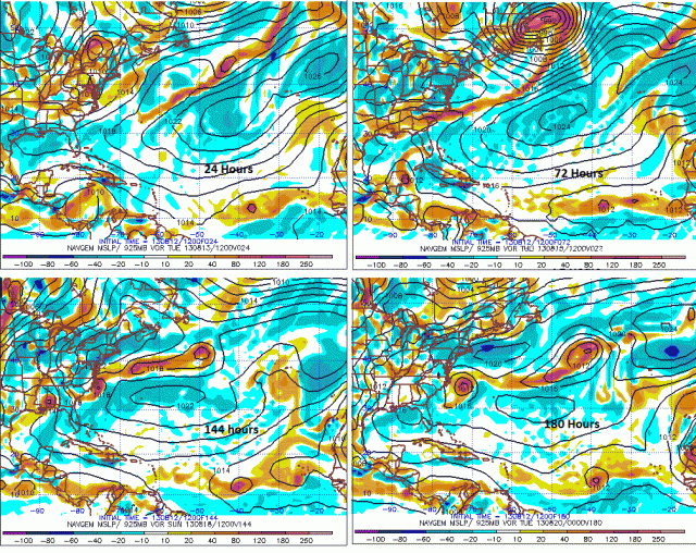
Actually, the 12Z Navgem now keeps it through next week, albeit not very strong and it moves really slowly. But since it's starting to pop some convection and conditions aren't that bad out there, I'm now a little more interested. Let's see if the 00Z GFS stasts doing something with it...

Image
0 likes   

User avatar
abajan
S2K Supporter
S2K Supporter
Posts: 4175
Joined: Sun Sep 07, 2003 5:10 am
Location: Barbados

Re: Tropical Wave / Pouch 20L in East Atlantic

#54 Postby abajan » Mon Aug 12, 2013 6:39 pm

Is the convection, indicated below, part of 20L? It seems to be growing:

Image

Uploaded with ImageShack.us
0 likes   

User avatar
cycloneye
Admin
Admin
Posts: 139593
Age: 67
Joined: Thu Oct 10, 2002 10:54 am
Location: San Juan, Puerto Rico

Re: Tropical Wave / Pouch 20L in East Atlantic

#55 Postby cycloneye » Mon Aug 12, 2013 6:42 pm

abajan wrote:Is the convection, indicated below, part of 20L? It seems to be growing:

http://img21.imageshack.us/img21/635/l42h.png

Uploaded with ImageShack.us


Yes,is part of the big wave envelope.Let's see if it get more thunderstorms.
0 likes   
Visit the Caribbean-Central America Weather Thread where you can find at first post web cams,radars
and observations from Caribbean basin members Click Here

User avatar
abajan
S2K Supporter
S2K Supporter
Posts: 4175
Joined: Sun Sep 07, 2003 5:10 am
Location: Barbados

Re: Tropical Wave / Pouch 20L in East Atlantic

#56 Postby abajan » Mon Aug 12, 2013 6:50 pm

beoumont wrote:... Can anyone recall and point out any other Swirlaroos that developed eventually.
Would Flora qualify as having developed from a swirlaroo?
0 likes   

User avatar
SFLcane
S2K Supporter
S2K Supporter
Posts: 9626
Age: 46
Joined: Sat Jun 05, 2010 1:44 pm
Location: Lake Worth Florida

Re: Tropical Wave / Pouch 20L in East Atlantic

#57 Postby SFLcane » Mon Aug 12, 2013 7:03 pm

development possible across the eastern atl during the next week or two.

Image
0 likes   

User avatar
Gustywind
Category 5
Category 5
Posts: 12334
Joined: Mon Sep 03, 2007 7:29 am
Location: Baie-Mahault, GUADELOUPE

#58 Postby Gustywind » Mon Aug 12, 2013 7:09 pm

8 PM discussion.


A TROPICAL WAVE ASSOCIATED WITH A 1010 MB LOW EMBEDDED WITHIN
THE MONSOON TROUGH EXTENDS AN AXIS FROM 19N33W TO 11N33W WHICH
IS MOVING W NEAR 10 KT. TOTAL PRECIPITABLE WATER IMAGERY SHOW
THAT FOR THE MOST PART THE WAVE IS EMBEDDED IN A HIGH MOIST
ENVIRONMENT AT THE LOWER LEVELS. HOWEVER...METEOSAT SATELLITE
IMAGERY SHOW SAHARAN DUST AND DRY AIR SPREADING OVER THE WAVE
ENVIRONMENT N OF THE MONSOON TROUGH WHERE CONVECTIVE ACTIVITY IS
MINIMAL. SCATTERED MODERATE CONVECTION IS FROM 07N-11N BETWEEN
27W-36W.
0 likes   

ninel conde
Category 5
Category 5
Posts: 1245
Joined: Mon Aug 04, 2008 2:18 pm

Re:

#59 Postby ninel conde » Mon Aug 12, 2013 8:04 pm

Gustywind wrote:8 PM discussion.


A TROPICAL WAVE ASSOCIATED WITH A 1010 MB LOW EMBEDDED WITHIN
THE MONSOON TROUGH EXTENDS AN AXIS FROM 19N33W TO 11N33W WHICH
IS MOVING W NEAR 10 KT. TOTAL PRECIPITABLE WATER IMAGERY SHOW
THAT FOR THE MOST PART THE WAVE IS EMBEDDED IN A HIGH MOIST
ENVIRONMENT AT THE LOWER LEVELS. HOWEVER...METEOSAT SATELLITE
IMAGERY SHOW SAHARAN DUST AND DRY AIR SPREADING OVER THE WAVE
ENVIRONMENT N OF THE MONSOON TROUGH WHERE CONVECTIVE ACTIVITY IS
MINIMAL. SCATTERED MODERATE CONVECTION IS FROM 07N-11N BETWEEN
27W-36W.


yea, there appears to be alot of dry air for it to deal with.
0 likes   
The posts in this forum are NOT official forecast and should not be used as such. They are just the opinion of the poster and may or may not be backed by sound meteorological data. They are NOT endorsed by any professional institution or storm2k.org. For official information, please refer to the NHC and NWS products.

User avatar
gatorcane
S2K Supporter
S2K Supporter
Posts: 23499
Age: 46
Joined: Sun Mar 13, 2005 3:54 pm
Location: Boca Raton, FL

#60 Postby gatorcane » Mon Aug 12, 2013 10:14 pm

Some convection is popping tonight but overall the environmental conditions are just not there for this system.

The 18Z GFS doesn't think the conditions will improve for Cape Verde development for quite sometime, may need to wait until towards the end of this month now, so could see a slow start to the Cape Verde season.
0 likes   


Return to “Talkin' Tropics”

Who is online

Users browsing this forum: Cat5James, Emmett_Brown, floridasun, Homie J, hurricanes1234, IcyTundra, NotSparta, skyline385, StormPyrate and 105 guests