2014 hurricane season forecasts

This is the general tropical discussion area. Anyone can take their shot at predicting a storms path.

Moderator: S2k Moderators

Forum rules

The posts in this forum are NOT official forecasts and should not be used as such. They are just the opinion of the poster and may or may not be backed by sound meteorological data. They are NOT endorsed by any professional institution or STORM2K. For official information, please refer to products from the National Hurricane Center and National Weather Service.

Help Support Storm2K
Message
Author
User avatar
wxman57
Moderator-Pro Met
Moderator-Pro Met
Posts: 22979
Age: 67
Joined: Sat Jun 21, 2003 8:06 pm
Location: Houston, TX (southwest)

Re: 2014 hurricane season forecasts

#41 Postby wxman57 » Wed Mar 19, 2014 1:05 pm

SouthFloridian92 wrote:I'm going with 10/4/1.


That matches my thinking. My coworker is pointing to 1982 (6/2/1), 1986 (6/4/0), 1991 (8/4/2) and 2002 (12/4/2) as analogs, with 2002 the best analog. Everything I see points to a more hostile environment than normal this season.
0 likes   

User avatar
Ntxw
Storm2k Moderator
Storm2k Moderator
Posts: 22786
Joined: Wed Oct 21, 2009 6:34 pm
Location: DFW, Texas

Re: 2014 hurricane season forecasts

#42 Postby Ntxw » Wed Mar 19, 2014 1:32 pm

wxman57 wrote:
SouthFloridian92 wrote:I'm going with 10/4/1.


That matches my thinking. My coworker is pointing to 1982 (6/2/1), 1986 (6/4/0), 1991 (8/4/2) and 2002 (12/4/2) as analogs, with 2002 the best analog. Everything I see points to a more hostile environment than normal this season.


Is this the long range guy you speak of often in winter? His analogs are all moderate to strong El Ninos.
0 likes   
The above post and any post by Ntxw is NOT an official forecast and should not be used as such. It is just the opinion of the poster and may or may not be backed by sound meteorological data. It is NOT endorsed by any professional institution including Storm2k. For official information, please refer to NWS products.

  Help support Storm2K!
Help Support Storm2K

User avatar
wxman57
Moderator-Pro Met
Moderator-Pro Met
Posts: 22979
Age: 67
Joined: Sat Jun 21, 2003 8:06 pm
Location: Houston, TX (southwest)

Re: 2014 hurricane season forecasts

#43 Postby wxman57 » Wed Mar 19, 2014 1:45 pm

Ntxw wrote:
wxman57 wrote:
SouthFloridian92 wrote:I'm going with 10/4/1.


That matches my thinking. My coworker is pointing to 1982 (6/2/1), 1986 (6/4/0), 1991 (8/4/2) and 2002 (12/4/2) as analogs, with 2002 the best analog. Everything I see points to a more hostile environment than normal this season.


Is this the long range guy you speak of often in winter? His analogs are all moderate to strong El Ninos.


Yes. El Nino at -.7 to -1.1 for this season. Negative Indian Ocean Dipole (cool Arabian Sea/near Somalia). Higher-than-normal pressures in deep tropics. Cooler SSTs in MDR. All signals point to diminished activity over normal. That doesn't mean no impacts, however. Seasons like 1957, 1965, 1983 and 1992 had well below normal activity (Audrey, Betsy, Alicia and Andrew). Bottom line is that you should prepare for each season the same, no matter what is forecast.
0 likes   

stephen23
Category 1
Category 1
Posts: 341
Joined: Sat Aug 04, 2012 10:57 pm
Location: North Fort Worth

#44 Postby stephen23 » Wed Mar 19, 2014 2:13 pm

My thinking is this. The only seasons since 1950 that have been El Nino PDO+ AMO+ during hurricane season were 1953 (14-6-4), 1957 (8-3-2), 1997 (8-3-1), 2004 (15-9-6). 2002 was a little of both. It started out the hurricane season as El Nino PDO- AMO- through end of July. There was only one named storm up until end of July. By August 2002 had changed to El Nino PDO+ AMO+ and all other storms formed during this time between August-Sept. So in this phase it went 11-4-2. Also something to note is all the years that have had El Nino PDO+ AMO+ have all had a hurricane landfall on the Gulf Coast. My predictions are the average of all years listed above at 11-5-3. Will go further and predict a hurricane making landfall on the gulf coast. If we were to stay in neutral ENSO with PDO+ AMO+ then the average of named storms goes up to 14-7-4.
0 likes   
Personal Forecast Disclaimer:
The posts in this forum are NOT official forecast and should not be used as such. They are just the opinion of the poster and may or may not be backed by sound meteorological data. They are NOT endorsed by any professional institution or storm2k.org. For official information, please refer to the NHC and NWS products.

User avatar
Ntxw
Storm2k Moderator
Storm2k Moderator
Posts: 22786
Joined: Wed Oct 21, 2009 6:34 pm
Location: DFW, Texas

Re:

#45 Postby Ntxw » Wed Mar 19, 2014 2:52 pm

stephen23 wrote:My thinking is this. The only seasons since 1950 that have been El Nino PDO+ AMO+ during hurricane season were 1953 (14-6-4), 1957 (8-3-2), 1997 (8-3-1), 2004 (15-9-6). 2002 was a little of both. It started out the hurricane season as El Nino PDO- AMO- through end of July. There was only one named storm up until end of July. By August 2002 had changed to El Nino PDO+ AMO+ and all other storms formed during this time between August-Sept. So in this phase it went 11-4-2. Also something to note is all the years that have had El Nino PDO+ AMO+ have all had a hurricane landfall on the Gulf Coast. My predictions are the average of all years listed above at 11-5-3. Will go further and predict a hurricane making landfall on the gulf coast. If we were to stay in neutral ENSO with PDO+ AMO+ then the average of named storms goes up to 14-7-4.


One question, why are you using +PDO/+AMO? A couple of positive does not claim a +PDO period as that is a multi-year index. If you are assuming the recent 2 +PDO readings then you should also assume the -AMO readings (likely two months as well as Feb pretty much repeated January). Unless this is all your assumption the +AMO will return and +PDO will remain due to a strong Nino (which it will take to keep the +PDO) as even the 1972 super Nino barely kept it positive during -PDO era as we are in.

Which If I had to pick, I would definitely take 1972 as fit for this season. But that is my personal opinion.
0 likes   
The above post and any post by Ntxw is NOT an official forecast and should not be used as such. It is just the opinion of the poster and may or may not be backed by sound meteorological data. It is NOT endorsed by any professional institution including Storm2k. For official information, please refer to NWS products.


  Help support Storm2K!

Help Support Storm2K


User avatar
TropicalAnalystwx13
Category 5
Category 5
Posts: 2109
Age: 27
Joined: Tue Jul 19, 2011 8:20 pm
Location: Wilmington, NC
Contact:

#46 Postby TropicalAnalystwx13 » Wed Mar 19, 2014 4:43 pm

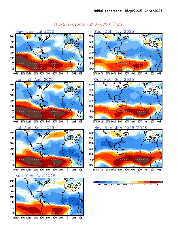
It's interesting to note the CFS' depiction of below-average wind shear across most of the Atlantic during the year despite the El Nino.

Image
0 likes   

User avatar
Ntxw
Storm2k Moderator
Storm2k Moderator
Posts: 22786
Joined: Wed Oct 21, 2009 6:34 pm
Location: DFW, Texas

Re: 2014 hurricane season forecasts

#47 Postby Ntxw » Wed Mar 19, 2014 10:01 pm

Ran into this information while searching through ENSO re-analysis. I need some people who have knowledge on this clarify because if this is true, there has been a lot of incorrect information regarding the matter. Sorry if it's derailing the thread, but I need some input.

Ntxw wrote:Here's something shocking that no one apparently has said anything about. Everyone says 1992 (Andrew) was during El Nino so I looked at the sub-surface then ONI. This is not correct, at least during the Hurricane season. JJA was neutral reading all the way to 1994 and there was NO sub-surface warm pool!!! In fact the only reasoning is that the El Nino of 1991-1992 was so strong it extended into spring of 1992 but by June it ended. There was no El Nino during hurricane Andrew!

Per ONI 1992: JJA = 0.3C, JAS = 0.0C

And during heart of the season ASO = -0.2C!

To be declared an El Nino there must be 5 consecutive trimonthlies overlapped with no disruptions, clearly there was not during Andrew 1992.
0 likes   
The above post and any post by Ntxw is NOT an official forecast and should not be used as such. It is just the opinion of the poster and may or may not be backed by sound meteorological data. It is NOT endorsed by any professional institution including Storm2k. For official information, please refer to NWS products.


  Help support Storm2K!

Help Support Storm2K


User avatar
TropicalAnalystwx13
Category 5
Category 5
Posts: 2109
Age: 27
Joined: Tue Jul 19, 2011 8:20 pm
Location: Wilmington, NC
Contact:

#48 Postby TropicalAnalystwx13 » Sat Mar 22, 2014 10:13 pm

It'll be interesting to see how much activity we get in the eastern Atlantic this season. An El Nino (higher shear) would argue for less activity, but it looks like we'll see a negative IOD and cool Gulf of Guinea once again this season--both promote a healthy wave train. Several TS Oscar 13s in store? As an added note, even if the waves don't develop far out, it's always possible they form closer to the coast.
0 likes   

Alyono
Professional-Met
Professional-Met
Posts: 6961
Joined: Fri Apr 26, 2013 3:52 pm
Location: Texas Coast

Re:

#49 Postby Alyono » Sun Mar 23, 2014 1:13 pm

TropicalAnalystwx13 wrote:It's interesting to note the CFS' depiction of below-average wind shear across most of the Atlantic during the year despite the El Nino.

Image


that's well above average shear south of 15N. That pattern would kill any waves that come across, only allowing for mid lat development
0 likes   

stephen23
Category 1
Category 1
Posts: 341
Joined: Sat Aug 04, 2012 10:57 pm
Location: North Fort Worth

#50 Postby stephen23 » Mon Mar 24, 2014 12:13 am

It does appear that the CFS is forecasting average to below average wind shear for most of the Caribbean, GOM, and East coast. Is this normal for Nino Years? The reason I ask is if you look back at past El Nino years back to 1950, while total number of named storms are below average during El Nino years, there also seems to be an increase in landfall Gulf coast hurricanes. Looking back at all years there were El Nino conditions for hurricane season, 80% of all years with El Nino values during hurricane season have had a landfall Gulf coast hurricane. The only years without one were 1951, 1982, and 2009. That is a lot higher odds then years that were La Nina or neutral. Now looking at the CFS forecasting PDO+ readings through hurricane season then the odds go up a little more. Without taking in consideration AMO, years with El Nino/PDO+ readings during hurricane season have had a landfall Gulf Coast hurricane 83% of the time. Out of those years with landfall hurricane 50% of those years had a Maj landfall hurricane in the US. Years with El Nino/PDO- reading during hurricane have only had a landfall Gulf Coast hurricane 67% of the time and a major hurricane landfall 33% of the time. Looking more at the CFS it looks like the CFS is also predicting the Atlantic to warm back up to average and above average sst in all the Atlantic except for at the equator. This would put us back into AMO+ readings by hurricane season. So more looking into this years that were El Nino/PDO+/AMO+ during hurricane season have had a landfall Gulf Coast hurricane 86% of the time. Years with El Nino/PDO+/AMO- reading during hurricane season have had a landfall Gulf Coast hurricane 80% of the time. Years with El Nino/PDO-/AMO+ readings during hurricane season have had a landfall Gulf Coast hurricane 0% of the time. This set up has only happened on time in 1951. Years with El Nino/PDO-/AMO- have had a landfall Gulf Coast hurricane 100% of the time. This set up has only happened two times in 1963, and 1969.

So, what I am asking is. Even though we all know that El Nino years produce fewer named storms for the most part, could El Nino years actually increase the chance of a Gulf Coast strike? If so, could it be due to where the shear is located actually decreasing the shear in Caribbean, GOM, and East Coast regions?
0 likes   
Personal Forecast Disclaimer:
The posts in this forum are NOT official forecast and should not be used as such. They are just the opinion of the poster and may or may not be backed by sound meteorological data. They are NOT endorsed by any professional institution or storm2k.org. For official information, please refer to the NHC and NWS products.

stephen23
Category 1
Category 1
Posts: 341
Joined: Sat Aug 04, 2012 10:57 pm
Location: North Fort Worth

Re: 2014 hurricane season forecasts

#51 Postby stephen23 » Mon Mar 24, 2014 2:16 am

stephen23 wrote:It does appear that the CFS is forecasting average to below average wind shear for most of the Caribbean, GOM, and East coast. Is this normal for Nino Years? The reason I ask is if you look back at past El Nino years back to 1950, while total number of named storms are below average during El Nino years, there also seems to be an increase in landfall Gulf coast hurricanes. Looking back at all years there were El Nino conditions for hurricane season, 80% of all years with El Nino values during hurricane season have had a landfall Gulf coast hurricane. The only years without one were 1951, 1982, and 2009. That is a lot higher odds then years that were La Nina or neutral. Now looking at the CFS forecasting PDO+ readings through hurricane season then the odds go up a little more. Without taking in consideration AMO, years with El Nino/PDO+ readings during hurricane season have had a landfall Gulf Coast hurricane 83% of the time. Out of those years with landfall hurricane 50% of those years had a Maj landfall hurricane in the US. Years with El Nino/PDO- reading during hurricane have only had a landfall Gulf Coast hurricane 67% of the time and a major hurricane landfall 33% of the time. Looking more at the CFS it looks like the CFS is also predicting the Atlantic to warm back up to average and above average sst in all the Atlantic except for at the equator. This would put us back into AMO+ readings by hurricane season. So more looking into this years that were El Nino/PDO+/AMO+ during hurricane season have had a landfall Gulf Coast hurricane 86% of the time. Years with El Nino/PDO+/AMO- reading during hurricane season have had a landfall Gulf Coast hurricane 80% of the time. Years with El Nino/PDO-/AMO+ readings during hurricane season have had a landfall Gulf Coast hurricane 0% of the time. This set up has only happened on time in 1951. Years with El Nino/PDO-/AMO- have had a landfall Gulf Coast hurricane 100% of the time. This set up has only happened two times in 1963, and 1969.

So, what I am asking is. Even though we all know that El Nino years produce fewer named storms for the most part, could El Nino years actually increase the chance of a Gulf Coast strike? If so, could it be due to where the shear is located actually decreasing the shear in Caribbean, GOM, and East Coast regions?


Just to show how many more times we have a landfall Gulf Coast hurricanes during El Nino years...

% of years with landfall Gulf Coast landfall with ENSO values during hurricane season:
El Nino= 80%
La Nina=56%
Neutral=48%

Completely opposite for east Coast Landfall hurricanes

% of years with landfall East Coast landfall with ENSO values during hurricane season:
El Nino=47%
La Nina=50%
Neutral=52%

And then combined U.S. landfall with ENSO values during hurricane season:
El Nino=80%
La Nina=69%
Neutral=71%
0 likes   
Personal Forecast Disclaimer:
The posts in this forum are NOT official forecast and should not be used as such. They are just the opinion of the poster and may or may not be backed by sound meteorological data. They are NOT endorsed by any professional institution or storm2k.org. For official information, please refer to the NHC and NWS products.

Alyono
Professional-Met
Professional-Met
Posts: 6961
Joined: Fri Apr 26, 2013 3:52 pm
Location: Texas Coast

Re:

#52 Postby Alyono » Mon Mar 24, 2014 5:59 am

stephen23 wrote:It does appear that the CFS is forecasting average to below average wind shear for most of the Caribbean, GOM, and East coast. Is this normal for Nino Years? The reason I ask is if you look back at past El Nino years back to 1950, while total number of named storms are below average during El Nino years, there also seems to be an increase in landfall Gulf coast hurricanes. Looking back at all years there were El Nino conditions for hurricane season, 80% of all years with El Nino values during hurricane season have had a landfall Gulf coast hurricane. The only years without one were 1951, 1982, and 2009. That is a lot higher odds then years that were La Nina or neutral. Now looking at the CFS forecasting PDO+ readings through hurricane season then the odds go up a little more. Without taking in consideration AMO, years with El Nino/PDO+ readings during hurricane season have had a landfall Gulf Coast hurricane 83% of the time. Out of those years with landfall hurricane 50% of those years had a Maj landfall hurricane in the US. Years with El Nino/PDO- reading during hurricane have only had a landfall Gulf Coast hurricane 67% of the time and a major hurricane landfall 33% of the time. Looking more at the CFS it looks like the CFS is also predicting the Atlantic to warm back up to average and above average sst in all the Atlantic except for at the equator. This would put us back into AMO+ readings by hurricane season. So more looking into this years that were El Nino/PDO+/AMO+ during hurricane season have had a landfall Gulf Coast hurricane 86% of the time. Years with El Nino/PDO+/AMO- reading during hurricane season have had a landfall Gulf Coast hurricane 80% of the time. Years with El Nino/PDO-/AMO+ readings during hurricane season have had a landfall Gulf Coast hurricane 0% of the time. This set up has only happened on time in 1951. Years with El Nino/PDO-/AMO- have had a landfall Gulf Coast hurricane 100% of the time. This set up has only happened two times in 1963, and 1969.

So, what I am asking is. Even though we all know that El Nino years produce fewer named storms for the most part, could El Nino years actually increase the chance of a Gulf Coast strike? If so, could it be due to where the shear is located actually decreasing the shear in Caribbean, GOM, and East Coast regions?


The CFS is showing HIGHER shear for the Caribbean. The reds are higher and they cover the entire Caribbean. It is the SUBTROPICS that have lower shear, not the deep tropics, except maybe for the area immediately west of the Coast of Africa
0 likes   

stephen23
Category 1
Category 1
Posts: 341
Joined: Sat Aug 04, 2012 10:57 pm
Location: North Fort Worth

Re: 2014 hurricane season forecasts

#53 Postby stephen23 » Mon Mar 24, 2014 11:58 am

Alyono wrote:
stephen23 wrote:It does appear that the CFS is forecasting average to below average wind shear for most of the Caribbean, GOM, and East coast. Is this normal for Nino Years? The reason I ask is if you look back at past El Nino years back to 1950, while total number of named storms are below average during El Nino years, there also seems to be an increase in landfall Gulf coast hurricanes. Looking back at all years there were El Nino conditions for hurricane season, 80% of all years with El Nino values during hurricane season have had a landfall Gulf coast hurricane. The only years without one were 1951, 1982, and 2009. That is a lot higher odds then years that were La Nina or neutral. Now looking at the CFS forecasting PDO+ readings through hurricane season then the odds go up a little more. Without taking in consideration AMO, years with El Nino/PDO+ readings during hurricane season have had a landfall Gulf Coast hurricane 83% of the time. Out of those years with landfall hurricane 50% of those years had a Maj landfall hurricane in the US. Years with El Nino/PDO- reading during hurricane have only had a landfall Gulf Coast hurricane 67% of the time and a major hurricane landfall 33% of the time. Looking more at the CFS it looks like the CFS is also predicting the Atlantic to warm back up to average and above average sst in all the Atlantic except for at the equator. This would put us back into AMO+ readings by hurricane season. So more looking into this years that were El Nino/PDO+/AMO+ during hurricane season have had a landfall Gulf Coast hurricane 86% of the time. Years with El Nino/PDO+/AMO- reading during hurricane season have had a landfall Gulf Coast hurricane 80% of the time. Years with El Nino/PDO-/AMO+ readings during hurricane season have had a landfall Gulf Coast hurricane 0% of the time. This set up has only happened on time in 1951. Years with El Nino/PDO-/AMO- have had a landfall Gulf Coast hurricane 100% of the time. This set up has only happened two times in 1963, and 1969.

So, what I am asking is. Even though we all know that El Nino years produce fewer named storms for the most part, could El Nino years actually increase the chance of a Gulf Coast strike? If so, could it be due to where the shear is located actually decreasing the shear in Caribbean, GOM, and East Coast regions?


The CFS is showing HIGHER shear for the Caribbean. The reds are higher and they cover the entire Caribbean. It is the SUBTROPICS that have lower shear, not the deep tropics, except maybe for the area immediately west of the Coast of Africa


O.K. I see what your talking about for Sept through end of year. I was looking at July and August where CFS is showing below average wind shear for entire Caribbean for July and below average wind shear for East Caribbean in August with average to below average wind shear for 75% of all the MDR, all of the GOM, and East Coast.
Image
0 likes   
Personal Forecast Disclaimer:
The posts in this forum are NOT official forecast and should not be used as such. They are just the opinion of the poster and may or may not be backed by sound meteorological data. They are NOT endorsed by any professional institution or storm2k.org. For official information, please refer to the NHC and NWS products.

User avatar
wxman57
Moderator-Pro Met
Moderator-Pro Met
Posts: 22979
Age: 67
Joined: Sat Jun 21, 2003 8:06 pm
Location: Houston, TX (southwest)

Re: 2014 hurricane season forecasts

#54 Postby wxman57 » Mon Mar 24, 2014 1:38 pm

Is this the same CFS that predicted the very warm winter east of the Rockies?
0 likes   

TheStormExpert

#55 Postby TheStormExpert » Mon Mar 24, 2014 2:36 pm

:uarrow: Also notice how it shows higher than average wind shear for at least 80-90% of the E. Pacific.
0 likes   

User avatar
Bocadude85
Category 5
Category 5
Posts: 2991
Age: 38
Joined: Mon Apr 18, 2005 2:20 pm
Location: Honolulu,Hi

Re: 2014 hurricane season forecasts

#56 Postby Bocadude85 » Mon Mar 24, 2014 3:56 pm

wxman57 wrote:Is this the same CFS that predicted the very warm winter east of the Rockies?


It has been a very warm winter down here in South Florida :D
0 likes   

User avatar
Ntxw
Storm2k Moderator
Storm2k Moderator
Posts: 22786
Joined: Wed Oct 21, 2009 6:34 pm
Location: DFW, Texas

Re: 2014 hurricane season forecasts

#57 Postby Ntxw » Tue Mar 25, 2014 6:13 pm

As many eyes are watching the Pacific, I decided to do some numbers crunching for ACE regarding El Nino. Perhaps it may give some insight as to what might occur when looking at total energy output of a season.


Using this graphic posted by our friend Cycloneye as guidance

http://i58.tinypic.com/aewapw.jpg

Average Atlantic ACE a season: 93.2 units

Average ACE during El Nino: 72 units; equates to in general below average
_______________________________________________________________________

Breaking down between the intensities:
Weak El Nino; 1951, 1976, 1977, 1994, 2004, 2006
Average ACE: 96.5 units; equates to in general near average to slightly above

Moderate El Nino: 1963, 1986, 1991, 2002, 2009
Average ACE: 62 units; equates to below average

Strong El Nino: 1957, 1965, 1972, 1982, 1997
Average ACE: 53 units; equates to well below average

Super El Nino or arguably +2C or the big 3; 1972, 1982, 1997
Average ACE: 32 units; equates to bottom tier top 15 quiet seasons


Disclaimer: All assuming an El Nino does play out by ASO. Does not assume any individual storms or impacts. For any land-falling statistics refer to Stephen23's great work
0 likes   
The above post and any post by Ntxw is NOT an official forecast and should not be used as such. It is just the opinion of the poster and may or may not be backed by sound meteorological data. It is NOT endorsed by any professional institution including Storm2k. For official information, please refer to NWS products.


  Help support Storm2K!

Help Support Storm2K


User avatar
CFLHurricane
Category 1
Category 1
Posts: 346
Joined: Thu Mar 27, 2014 5:56 pm
Location: Floriduh

Re: 2014 hurricane season forecasts

#58 Postby CFLHurricane » Fri Mar 28, 2014 3:09 am

I'm think we'll have a slightly below normal year since anything as slow as last year again would be the anomaly.
0 likes   
I'm not a meteorologist, but I did stay at a motel 8.

User avatar
Hurricane Jed
Category 2
Category 2
Posts: 545
Age: 37
Joined: Mon Jan 24, 2011 3:36 pm
Location: Cen Tex

#59 Postby Hurricane Jed » Fri Mar 28, 2014 7:27 pm

I'm going to hold off til April or May on any predictions. I want to see how things develop with this likely El Nino.
0 likes   

User avatar
Ntxw
Storm2k Moderator
Storm2k Moderator
Posts: 22786
Joined: Wed Oct 21, 2009 6:34 pm
Location: DFW, Texas

#60 Postby Ntxw » Sat Mar 29, 2014 12:04 pm

AMO had another negative reading at -0.020 however it was a little higher than last month. This would be back to back months.
0 likes   
The above post and any post by Ntxw is NOT an official forecast and should not be used as such. It is just the opinion of the poster and may or may not be backed by sound meteorological data. It is NOT endorsed by any professional institution including Storm2k. For official information, please refer to NWS products.


  Help support Storm2K!

Help Support Storm2K


Return to “Talkin' Tropics”

Who is online

Users browsing this forum: Category5Kaiju and 34 guests