Wave well east of Lesser Antilles (Is INVEST 96L)
Moderator: S2k Moderators
Forum rules

The posts in this forum are NOT official forecasts and should not be used as such. They are just the opinion of the poster and may or may not be backed by sound meteorological data. They are NOT endorsed by any professional institution or STORM2K. For official information, please refer to products from the National Hurricane Center and National Weather Service.
-
cycloneye

- Admin

- Posts: 149222
- Age: 69
- Joined: Thu Oct 10, 2002 10:54 am
- Location: San Juan, Puerto Rico
Re: Wave east of 94L
Still no mention of this wave in TWO.
1 likes
Visit the Caribbean-Central America Weather Thread where you can find at first post web cams,radars
and observations from Caribbean basin members Click Here
and observations from Caribbean basin members Click Here
-
gatorcane

- S2K Supporter

- Posts: 23708
- Age: 48
- Joined: Sun Mar 13, 2005 3:54 pm
- Location: Boca Raton, FL
Re: Wave east of 94L
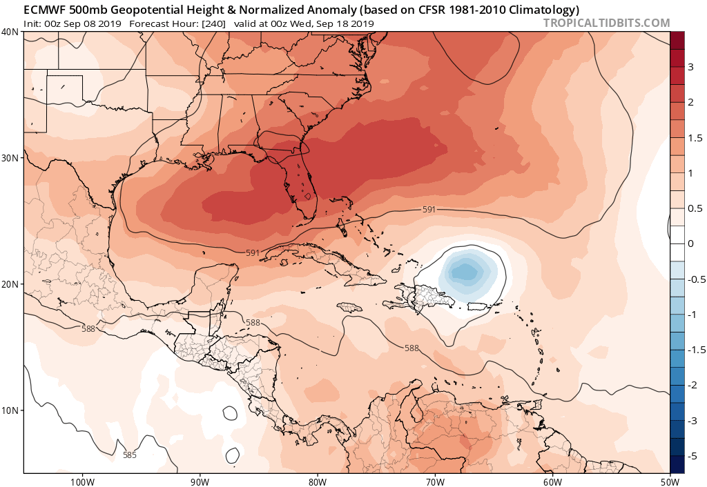
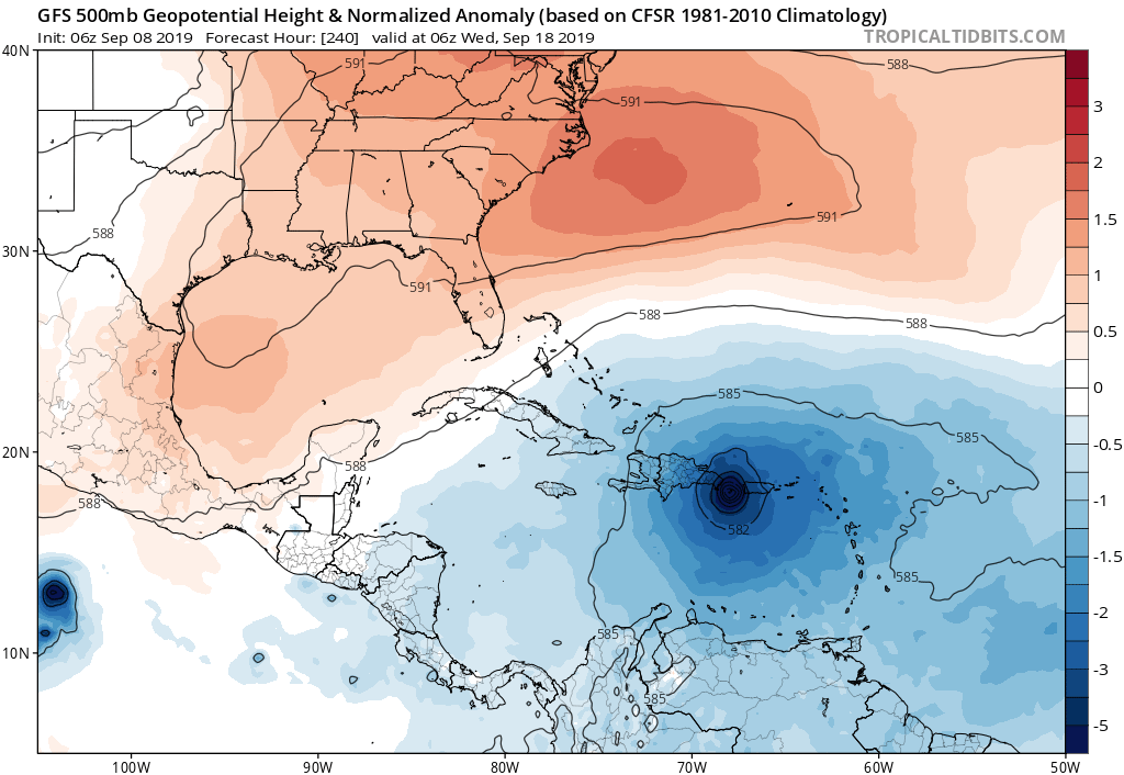
00Z EC and 06Z GFS 10 day position with expansive ridging over the SE CONUS and SW Atlantic thanks to a positive NAO:
0 likes
-
northjaxpro

- S2K Supporter
- Posts: 8900
- Joined: Mon Sep 27, 2010 11:21 am
- Location: Jacksonville, FL
Re: Wave east of 94L
0 likes
NEVER, EVER SAY NEVER in the tropics and weather in general, and most importantly, with life itself!!
________________________________________________________________________________________
Fay 2008 Beryl 2012 Debby 2012 Colin 2016 Hermine 2016 Julia 2016 Matthew 2016 Irma 2017 Dorian 2019
________________________________________________________________________________________
Fay 2008 Beryl 2012 Debby 2012 Colin 2016 Hermine 2016 Julia 2016 Matthew 2016 Irma 2017 Dorian 2019
-
wxman57

- Moderator-Pro Met

- Posts: 23171
- Age: 68
- Joined: Sat Jun 21, 2003 8:06 pm
- Location: Houston, TX (southwest)
Re: Wave east of 94L
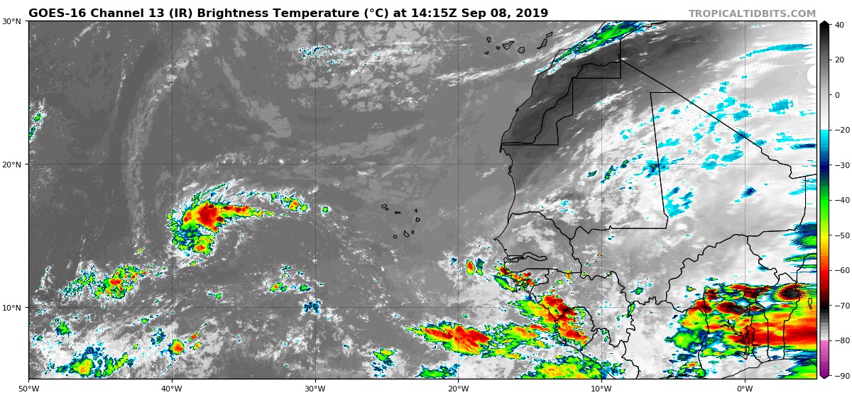
I don't see any wave east of 94L, but the GFS doesn't appear to be developing 94L. Look at the 850mb vorticity. The GFS has it passing 40W next Friday, while 94L is already nearing 40W. You can see the system in the 00Z GFS near the Cape Verde Islands Tuesday night. The GFS is focusing on something that is still over Africa. Euro develops something, too. I can't see anything significant there on satellite.
I don't think that the Bahamas or SE U.S. are ready for another major hurricane. Very early, though, it always comes down to timing. Maybe it'll turn out to sea. Better yet, perhaps it's only a model-cane.
I don't think that the Bahamas or SE U.S. are ready for another major hurricane. Very early, though, it always comes down to timing. Maybe it'll turn out to sea. Better yet, perhaps it's only a model-cane.
0 likes
-
Hurricaneman

- Category 5

- Posts: 7404
- Age: 45
- Joined: Tue Aug 31, 2004 3:24 pm
- Location: central florida
Re: Wave east of 94L
wxman57 wrote:I don't see any wave east of 94L, but the GFS doesn't appear to be developing 94L. Look at the 850mb vorticity. The GFS has it passing 40W next Friday, while 94L is already nearing 40W. You can see the system in the 00Z GFS near the Cape Verde Islands Tuesday night. The GFS is focusing on something that is still over Africa. Euro develops something, too. I can't see anything significant there on satellite.
I don't think that the Bahamas or SE U.S. are ready for another major hurricane. Very early, though, it always comes down to timing. Maybe it'll turn out to sea. Better yet, perhaps it's only a model-cane.
If in fact it’s a model-cane it’s on all models and means all the models need to be worked on but imo the signal for something to form from that area of some kind is overwhelming
0 likes
-
gatorcane
- S2K Supporter
- Posts: 23708
- Age: 48
- Joined: Sun Mar 13, 2005 3:54 pm
- Location: Boca Raton, FL
Re: Wave east of 94L
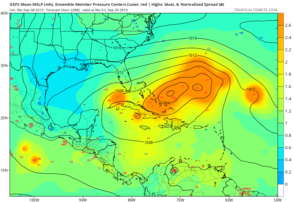
Very strong signal on the GEFS but most turn out to sea though it is the super long range and it is based on the old GFS core
2 likes
-
ouragans

- Category 2

- Posts: 501
- Age: 54
- Joined: Sun Jun 12, 2011 12:09 pm
- Location: Abymes, Guadeloupe F.W.I
- Contact:
Re: Wave east of 94L
From TWD
A tropical wave near the coast of Africa is along 17W S of 20N, moving W at around 10-15 kt. Scattered moderate convection is in the vicinity of the wave axis from 08N-17N between 10W-20W.
0 likes
Personal forecast disclaimer
This post is a personal point of view, not an information. Please refer to official statements for life-threatening decisions.
David '79, Frederic '79, Hugo '89, Iris, Luis & Marilyn '95, Georges '98, Lenny '99, Dean '07, Irma '17, Maria '17, Fiona '22, Philippe '23, Tammy '23
16°13'33.3,"6N -61°36'39.5"W
-
Hypercane_Kyle

- Category 5
- Posts: 3465
- Joined: Sat Mar 07, 2015 7:58 pm
- Location: Cape Canaveral, FL
Re: Wave east of 94L
00z UKMET now also very bullish on this system.
0 likes
My posts are my own personal opinion, defer to the National Hurricane Center (NHC) and other NOAA products for decision making during hurricane season.
-
wxman57
- Moderator-Pro Met
- Posts: 23171
- Age: 68
- Joined: Sat Jun 21, 2003 8:06 pm
- Location: Houston, TX (southwest)
Re: Wave east of 94L
ouragans wrote:From TWDA tropical wave near the coast of Africa is along 17W S of 20N, moving W at around 10-15 kt. Scattered moderate convection is in the vicinity of the wave axis from 08N-17N between 10W-20W.
I'm not seeing anything along 17W on the TPW loop. GFS has it reaching the Cape Verde islands in 72 hrs, so it must still be over Africa.
0 likes
-
TheStormExpert
Re: Wave east of 94L
Hypercane_Kyle wrote:00z UKMET now also very bullish on this system.
Do you have an image of the track and intensity?
0 likes
-
TheStormExpert
Re: Wave east of 94L
gatorcane wrote:Very strong signal on the GEFS but most turn out to sea though it is the super long range and it is based on the old GFS core
https://i.postimg.cc/4yvJJgMk/gfs-ememb-lowlocs-watl-49.png
Some of those members are pretty strong, one goes down to 933mb!

Keep your fingers crossed that this recurves east of the U.S. and The Bahamas, we aren’t ready for another significant hurricane threat.
Last edited by TheStormExpert on Sun Sep 08, 2019 9:04 am, edited 1 time in total.
0 likes
-
Hypercane_Kyle
- Category 5
- Posts: 3465
- Joined: Sat Mar 07, 2015 7:58 pm
- Location: Cape Canaveral, FL
Re: Wave east of 94L
TheStormExpert wrote:Hypercane_Kyle wrote:00z UKMET now also very bullish on this system.
Do you have an image of the track and intensity?
Looks to be a hurricane by D7.

0 likes
My posts are my own personal opinion, defer to the National Hurricane Center (NHC) and other NOAA products for decision making during hurricane season.
-
TheStormExpert
Re: Wave east of 94L
Hypercane_Kyle wrote:TheStormExpert wrote:Hypercane_Kyle wrote:00z UKMET now also very bullish on this system.
Do you have an image of the track and intensity?
Looks to be a hurricane by D7.
https://i.imgur.com/bPMZkmR.png
Thanks! Wonder if it would go OTS from there?
0 likes
-
Hypercane_Kyle
- Category 5
- Posts: 3465
- Joined: Sat Mar 07, 2015 7:58 pm
- Location: Cape Canaveral, FL
Re: Wave east of 94L
TheStormExpert wrote:Hypercane_Kyle wrote:TheStormExpert wrote:Do you have an image of the track and intensity?
Looks to be a hurricane by D7.
https://i.imgur.com/bPMZkmR.png
Thanks! Wonder if it would go OTS from there?
Most probably, really ramps it up quick.
0 likes
My posts are my own personal opinion, defer to the National Hurricane Center (NHC) and other NOAA products for decision making during hurricane season.
-
SFLcane

- S2K Supporter
- Posts: 10281
- Age: 48
- Joined: Sat Jun 05, 2010 1:44 pm
- Location: Lake Worth Florida
Re: Wave east of 94L
Quite the concentration of ensembles near PR though not sure we’re its coming from.

0 likes
-
Hurricaneman
- Category 5
- Posts: 7404
- Age: 45
- Joined: Tue Aug 31, 2004 3:24 pm
- Location: central florida
Re: Wave east of 94L
From what I can see it’s over southern Mali entering Sénégal if my eyes aren’t deceiving me
0 likes
-
SFLcane
- S2K Supporter
- Posts: 10281
- Age: 48
- Joined: Sat Jun 05, 2010 1:44 pm
- Location: Lake Worth Florida
Re: Wave east of 94L
Long range GFS has this wave cut right in between Haiti and PR like Dorian. What are the odds?  plenty of hurricane season left

1 likes
-
ouragans
- Category 2
- Posts: 501
- Age: 54
- Joined: Sun Jun 12, 2011 12:09 pm
- Location: Abymes, Guadeloupe F.W.I
- Contact:
Re: Wave east of 94L
wxman57 wrote:ouragans wrote:From TWDA tropical wave near the coast of Africa is along 17W S of 20N, moving W at around 10-15 kt. Scattered moderate convection is in the vicinity of the wave axis from 08N-17N between 10W-20W.
I'm not seeing anything along 17W on the TPW loop. GFS has it reaching the Cape Verde islands in 72 hrs, so it must still be over Africa.
So for you it's still not the right one, shown by the models? The next over Ivory Coast?
1 likes
Personal forecast disclaimer
This post is a personal point of view, not an information. Please refer to official statements for life-threatening decisions.
David '79, Frederic '79, Hugo '89, Iris, Luis & Marilyn '95, Georges '98, Lenny '99, Dean '07, Irma '17, Maria '17, Fiona '22, Philippe '23, Tammy '23
16°13'33.3,"6N -61°36'39.5"W
This post is a personal point of view, not an information. Please refer to official statements for life-threatening decisions.
David '79, Frederic '79, Hugo '89, Iris, Luis & Marilyn '95, Georges '98, Lenny '99, Dean '07, Irma '17, Maria '17, Fiona '22, Philippe '23, Tammy '23
16°13'33.3,"6N -61°36'39.5"W
Who is online
Users browsing this forum: No registered users and 69 guests