https://twitter.com/CraigSetzer/status/1567525552591888385
Central Atlantic Tropical Wave (Is Invest 96L)
Moderator: S2k Moderators
Forum rules

The posts in this forum are NOT official forecasts and should not be used as such. They are just the opinion of the poster and may or may not be backed by sound meteorological data. They are NOT endorsed by any professional institution or STORM2K. For official information, please refer to products from the National Hurricane Center and National Weather Service.
-
AutoPenalti
- Category 5

- Posts: 4091
- Age: 29
- Joined: Mon Aug 17, 2015 4:16 pm
- Location: Ft. Lauderdale, Florida
Re: Tropical Wave emerging from West Africa
2 likes
The posts in this forum are NOT official forecasts and should not be used as such. They are just the opinion of the poster and may or may not be backed by sound meteorological data. They are NOT endorsed by any professional institution or STORM2K. For official information, please refer to products from the NHC and NWS.
Model Runs Cheat Sheet:
GFS (5:30 AM/PM, 11:30 AM/PM)
HWRF, GFDL, UKMET, NAVGEM (6:30-8:00 AM/PM, 12:30-2:00 AM/PM)
ECMWF (1:45 AM/PM)
TCVN is a weighted averaged
-
SFLcane

- S2K Supporter

- Posts: 10281
- Age: 48
- Joined: Sat Jun 05, 2010 1:44 pm
- Location: Lake Worth Florida
-
cycloneye

- Admin

- Posts: 149708
- Age: 69
- Joined: Thu Oct 10, 2002 10:54 am
- Location: San Juan, Puerto Rico
Re: Tropical Wave emerging from West Africa
SFLcane wrote:Nothing develops that quick in 2022 gfs is bluff.
You were 100% right.
0 likes
Visit the Caribbean-Central America Weather Thread where you can find at first post web cams,radars
and observations from Caribbean basin members Click Here
and observations from Caribbean basin members Click Here
Re: Tropical Wave emerging from West Africa
For the first time in seven runs, the 12Z UKMET doesn't make this a TC! Keep in mind that the UKMET was the first model to develop this into a TD. Is it now saying "psyche"? 
Last edited by LarryWx on Wed Sep 07, 2022 11:25 am, edited 1 time in total.
1 likes
Personal Forecast Disclaimer:
The posts in this forum are NOT official forecasts and should not be used as such. They are just the opinion of the poster and may or may not be backed by sound meteorological data. They are NOT endorsed by any professional institution or storm2k.org. For official information, please refer to the NHC and NWS products.
The posts in this forum are NOT official forecasts and should not be used as such. They are just the opinion of the poster and may or may not be backed by sound meteorological data. They are NOT endorsed by any professional institution or storm2k.org. For official information, please refer to the NHC and NWS products.
-
SFLcane
- S2K Supporter
- Posts: 10281
- Age: 48
- Joined: Sat Jun 05, 2010 1:44 pm
- Location: Lake Worth Florida
Re: Tropical Wave emerging from West Africa
SFLcane wrote:
Very interesting indeed.
But there is no TC lol.
1 likes
-
AutoPenalti
- Category 5
- Posts: 4091
- Age: 29
- Joined: Mon Aug 17, 2015 4:16 pm
- Location: Ft. Lauderdale, Florida
Re: Tropical Wave emerging from West Africa
Dry air dominates the region again.
0 likes
The posts in this forum are NOT official forecasts and should not be used as such. They are just the opinion of the poster and may or may not be backed by sound meteorological data. They are NOT endorsed by any professional institution or STORM2K. For official information, please refer to products from the NHC and NWS.
Model Runs Cheat Sheet:
GFS (5:30 AM/PM, 11:30 AM/PM)
HWRF, GFDL, UKMET, NAVGEM (6:30-8:00 AM/PM, 12:30-2:00 AM/PM)
ECMWF (1:45 AM/PM)
TCVN is a weighted averaged


Re: Tropical Wave emerging from West Africa
SFLcane wrote:SFLcane wrote:
Very interesting indeed.
But there is no TC lol.
You've got to love the tropics!
Not surprisingly, the 12Z GEFS is following the operational's lead with a weaker and further south mean.
0 likes
Personal Forecast Disclaimer:
The posts in this forum are NOT official forecasts and should not be used as such. They are just the opinion of the poster and may or may not be backed by sound meteorological data. They are NOT endorsed by any professional institution or storm2k.org. For official information, please refer to the NHC and NWS products.
The posts in this forum are NOT official forecasts and should not be used as such. They are just the opinion of the poster and may or may not be backed by sound meteorological data. They are NOT endorsed by any professional institution or storm2k.org. For official information, please refer to the NHC and NWS products.
Re: Tropical Wave emerging from West Africa
12Z CMC still has only a weak surface reflection. It is just NE of PR at 240 moving WNW in what's technically a dangerous position. But a very weak low wouldn't be particularly dangerous fortunately.
0 likes
Personal Forecast Disclaimer:
The posts in this forum are NOT official forecasts and should not be used as such. They are just the opinion of the poster and may or may not be backed by sound meteorological data. They are NOT endorsed by any professional institution or storm2k.org. For official information, please refer to the NHC and NWS products.
The posts in this forum are NOT official forecasts and should not be used as such. They are just the opinion of the poster and may or may not be backed by sound meteorological data. They are NOT endorsed by any professional institution or storm2k.org. For official information, please refer to the NHC and NWS products.
-
cycloneye
- Admin
- Posts: 149708
- Age: 69
- Joined: Thu Oct 10, 2002 10:54 am
- Location: San Juan, Puerto Rico
Re: Tropical Wave emerging from West Africa
2. African Coast:
A tropical wave currently located near the west African coast is
forecast to emerge offshore into the eastern Atlantic over the next
day or so. Environmental conditions appear conducive for some
gradual development thereafter as the system moves
west-northwestward over the eastern tropical Atlantic.
* Formation chance through 48 hours...low...near 0 percent.
* Formation chance through 5 days...low...30 percent.
0 likes
Visit the Caribbean-Central America Weather Thread where you can find at first post web cams,radars
and observations from Caribbean basin members Click Here
and observations from Caribbean basin members Click Here

Re: Tropical Wave emerging from West Africa
This might end up as another Earl, struggling for much of its time in the MDR before developing west of 55-60W. Or it’ll surprise all the models and develop while it’s still below 15N during the next few days. This is one of the furthest south and smallest waves this season, so it could be spared from the problems other waves have faced this year with dry air and competing centers.
0 likes
Irene '11 Sandy '12 Hermine '16 5/15/2018 Derecho Fay '20 Isaias '20 Elsa '21 Henri '21 Ida '21
I am only a meteorology enthusiast who knows a decent amount about tropical cyclones. Look to the professional mets, the NHC, or your local weather office for the best information.
I am only a meteorology enthusiast who knows a decent amount about tropical cyclones. Look to the professional mets, the NHC, or your local weather office for the best information.
Re: Tropical Wave emerging from West Africa
The 12Z EPS has ~30% of the members become a H. A handful of them threaten the Leewards to Bermuda corridor 9/19-22. Two of them hit near the NC/SC border 9/20-22. All fwiw.
1 likes
Personal Forecast Disclaimer:
The posts in this forum are NOT official forecasts and should not be used as such. They are just the opinion of the poster and may or may not be backed by sound meteorological data. They are NOT endorsed by any professional institution or storm2k.org. For official information, please refer to the NHC and NWS products.
The posts in this forum are NOT official forecasts and should not be used as such. They are just the opinion of the poster and may or may not be backed by sound meteorological data. They are NOT endorsed by any professional institution or storm2k.org. For official information, please refer to the NHC and NWS products.
-
cycloneye
- Admin
- Posts: 149708
- Age: 69
- Joined: Thu Oct 10, 2002 10:54 am
- Location: San Juan, Puerto Rico
Re: Tropical Wave emerging from West Africa

4 likes
Visit the Caribbean-Central America Weather Thread where you can find at first post web cams,radars
and observations from Caribbean basin members Click Here
and observations from Caribbean basin members Click Here
Re: Tropical Wave off the African Coast
0Z ICON illustrates well the danger of this becoming a weak surface low but also remaining weak and thus less likely to recurve safely. This has it still weak at 19N, 58W, moving W toward the far NE Caribbean with no trough looking to recurve it out anytime soon after and with it moving toward very warm SSTs.
2 likes
Personal Forecast Disclaimer:
The posts in this forum are NOT official forecasts and should not be used as such. They are just the opinion of the poster and may or may not be backed by sound meteorological data. They are NOT endorsed by any professional institution or storm2k.org. For official information, please refer to the NHC and NWS products.
The posts in this forum are NOT official forecasts and should not be used as such. They are just the opinion of the poster and may or may not be backed by sound meteorological data. They are NOT endorsed by any professional institution or storm2k.org. For official information, please refer to the NHC and NWS products.
Re: Tropical Wave off the African Coast
After just one run without it, it is back on the 0Z UKMET though it is more delayed than ever:
NEW TROPICAL CYCLONE FORECAST TO DEVELOP AFTER 126 HOURS
FORECAST POSITION AT T+126 : 19.0N 46.9W
LEAD CENTRAL MAXIMUM WIND
VERIFYING TIME TIME POSITION PRESSURE (MB) SPEED (KNOTS)
-------------- ---- -------- ------------- -------------
1200UTC 13.09.2022 132 19.7N 48.3W 1010 29
0000UTC 14.09.2022 144 20.8N 50.5W 1009 29
Edit: The 0Z Euro's very early recurve is a clearcut outlier to the 0Z EPS as only two others of the other 50 members are anywhere near as far north.
2 likes
Personal Forecast Disclaimer:
The posts in this forum are NOT official forecasts and should not be used as such. They are just the opinion of the poster and may or may not be backed by sound meteorological data. They are NOT endorsed by any professional institution or storm2k.org. For official information, please refer to the NHC and NWS products.
The posts in this forum are NOT official forecasts and should not be used as such. They are just the opinion of the poster and may or may not be backed by sound meteorological data. They are NOT endorsed by any professional institution or storm2k.org. For official information, please refer to the NHC and NWS products.
-
Blown Away

- S2K Supporter
- Posts: 10253
- Joined: Wed May 26, 2004 6:17 am
Re: Tropical Wave off the African Coast
LarryWx wrote:0Z ICON illustrates well the danger of this becoming a weak surface low but also remaining weak and thus less likely to recurve safely. This has it still weak at 19N, 58W, moving W toward the far NE Caribbean with no trough looking to recurve it out anytime soon after and with it moving toward very warm SSTs.
Long range modeling at times has shown this "blocking ridge" that many tweet about that allows systems farther W, but once the modeling gets within 10 days they all recurve OTS. Bermuda being the exception, IMO the only way this season a TS/Hurricane impacts any landmass will be if one develops in the Caribbean or GOM.
Back in June/July the CFS was all over the place, but it did somewhat correctly show nearly all the lows in the Atlantic moving N and not impacting Caribbean/CONUS.
1 likes
Hurricane Eye Experience: David 79, Irene 99, Frances 04, Jeanne 04, Wilma 05… Hurricane Brush Experience: Andrew 92, Erin 95, Floyd 99, Matthew 16, Irma 17, Ian 22, Nicole 22…
-
cycloneye
- Admin
- Posts: 149708
- Age: 69
- Joined: Thu Oct 10, 2002 10:54 am
- Location: San Juan, Puerto Rico
Re: Tropical Wave off the African Coast
2. West Coast of Africa:
A tropical wave currently located near the west coast of Africa is
forecast to emerge into the eastern Atlantic later this morning.
Environmental conditions appear conducive for some gradual
development thereafter as the system moves west-northwestward over
the eastern tropical Atlantic.
* Formation chance through 48 hours...low...near 0 percent.
* Formation chance through 5 days...low...30 percent.
0 likes
Visit the Caribbean-Central America Weather Thread where you can find at first post web cams,radars
and observations from Caribbean basin members Click Here
and observations from Caribbean basin members Click Here
Re: Tropical Wave off the African Coast
NEW TROPICAL CYCLONE FORECAST TO DEVELOP AFTER 96 HOURS
FORECAST POSITION AT T+ 96 : 14.9N 43.8W
LEAD CENTRAL MAXIMUM WIND
VERIFYING TIME TIME POSITION PRESSURE (MB) SPEED (KNOTS)
-------------- ---- -------- ------------- -------------
1200UTC 12.09.2022 96 14.9N 43.8W 1009 25
0000UTC 13.09.2022 108 16.8N 46.0W 1008 31
1200UTC 13.09.2022 120 18.4N 48.8W 1007 38
0000UTC 14.09.2022 132 18.9N 51.1W 1007 33
1200UTC 14.09.2022 144 19.3N 53.9W 1006 39
0 likes
Personal Forecast Disclaimer:
The posts in this forum are NOT official forecasts and should not be used as such. They are just the opinion of the poster and may or may not be backed by sound meteorological data. They are NOT endorsed by any professional institution or storm2k.org. For official information, please refer to the NHC and NWS products.
The posts in this forum are NOT official forecasts and should not be used as such. They are just the opinion of the poster and may or may not be backed by sound meteorological data. They are NOT endorsed by any professional institution or storm2k.org. For official information, please refer to the NHC and NWS products.
-
SFLcane
- S2K Supporter
- Posts: 10281
- Age: 48
- Joined: Sat Jun 05, 2010 1:44 pm
- Location: Lake Worth Florida
Re: Tropical Wave off the African Coast
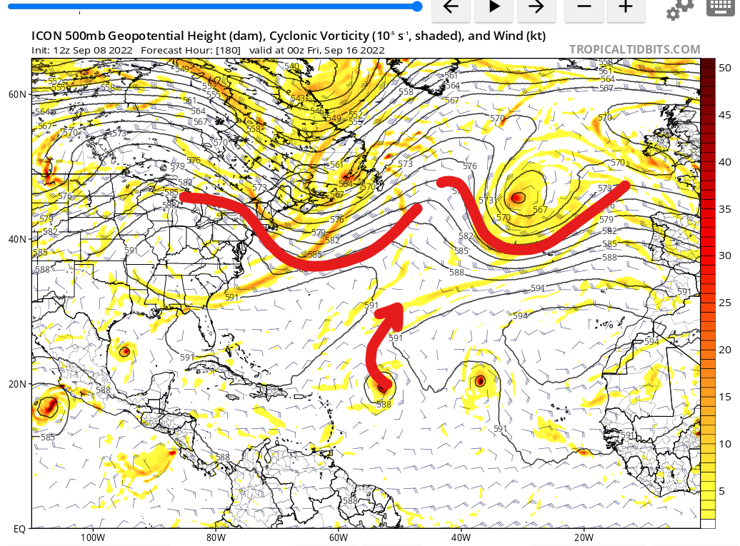
Icon develops this wave and brings it west until the trap door opens. Pattern is way to progressive for anything to make it far west before these trofs weaken the ridge.
0 likes
-
cajungal
- Category 5
- Posts: 2354
- Age: 49
- Joined: Sun Mar 14, 2004 9:34 pm
- Location: Schriever, Louisiana (60 miles southwest of New Orleans)
Re: Tropical Wave off the African Coast
SFLcane wrote:Icon develops this wave and brings it west until the trap door opens. Pattern is way to progressive for anything to make it far west before these trofs weaken the ridge.
https://i.postimg.cc/L6ZSL4j6/icon.png
What is that in the gulf? Don’t remember anyone mentioning it
0 likes
Who is online
Users browsing this forum: No registered users and 229 guests