90L Invest SW Caribbean

This is the general tropical discussion area. Anyone can take their shot at predicting a storms path.

Moderator: S2k Moderators

Forum rules

The posts in this forum are NOT official forecasts and should not be used as such. They are just the opinion of the poster and may or may not be backed by sound meteorological data. They are NOT endorsed by any professional institution or STORM2K. For official information, please refer to products from the National Hurricane Center and National Weather Service.

Help Support Storm2K
Message
Author
User avatar
wxmann_91
Category 5
Category 5
Posts: 8013
Age: 34
Joined: Fri Jul 15, 2005 2:49 pm
Location: Southern California
Contact:

#41 Postby wxmann_91 » Tue Oct 25, 2005 8:35 pm

tampaflwx wrote:someone made an insightful comment in the first thread regarding this system that i keep wondering about... didn't wilma cool off these caribbean waters at ALL??


Yes they did, and that's why this may not be as strong as Wilma, even if it doesn't hit Central America.

But remember that any cooling was probably limited by the deepness of the warm waters of the Caribbean. And remember Wilma wasn't moving too slow, a stalled out TS upwells more than a 20 mph Cat 5.
0 likes   

tampaflwx
Tropical Storm
Tropical Storm
Posts: 134
Joined: Sun Oct 16, 2005 3:51 pm

#42 Postby tampaflwx » Tue Oct 25, 2005 8:36 pm

i imagine when the GFDL is run it will show something similar to the GFS, not too far off from the LBAR in this particular case. the LBAR is wack for most forecasts, but by chance/historical data it is right sometimes in long-term forecasting.
0 likes   

User avatar
beachbum_al
Category 5
Category 5
Posts: 2163
Age: 55
Joined: Thu Jul 14, 2005 9:23 pm
Location: South Alabama Coast
Contact:

#43 Postby beachbum_al » Tue Oct 25, 2005 8:38 pm

Where are these coming from? It is like I go to work, come home, get the girls tuck in their beds, check email, then a few sites I enjoy going to and look here and there is something out in the carribean. Wow what a year.
0 likes   

User avatar
Ivanhater
Storm2k Moderator
Storm2k Moderator
Posts: 11162
Age: 38
Joined: Fri Jul 01, 2005 8:25 am
Location: Pensacola

#44 Postby Ivanhater » Tue Oct 25, 2005 8:39 pm

beachbum_al wrote:Where are these coming from? It is like I go to work, come home, get the girls tuck in their beds, check email, then a few sites I enjoy going to and look here and there is something out in the carribean. Wow what a year.


tell me about it!
0 likes   

krysof

#45 Postby krysof » Tue Oct 25, 2005 8:42 pm

does anyone have the shear charts to see if this thing has a good potential to develop
0 likes   

tampaflwx
Tropical Storm
Tropical Storm
Posts: 134
Joined: Sun Oct 16, 2005 3:51 pm

#46 Postby tampaflwx » Tue Oct 25, 2005 8:42 pm

what strikes me about this invest are a few things..

a) it's the 2005 atlantic season...we just saw alpha...
b) wilma
c) the expanse of clouds shows potential for a large encompassing system
d) historical tracks point towards moving north
e) models picking up the development of a formidable system
f) great banding features already
g) apparently the waters are still warm, low shear also
0 likes   

User avatar
cycloneye
Admin
Admin
Posts: 146250
Age: 69
Joined: Thu Oct 10, 2002 10:54 am
Location: San Juan, Puerto Rico

#47 Postby cycloneye » Tue Oct 25, 2005 8:44 pm

ivanhater wrote:lets hope this slams into central america, otherwise, im afraid this might turn into a bad one :eek:


Ivan on the contrary let's hope it dissipates and not affect anyone as those folks in CentralAmerica dont need more than what Stan caused.
0 likes   
Visit the Caribbean-Central America Weather Thread where you can find at first post web cams,radars
and observations from Caribbean basin members Click Here

User avatar
rainydaze
Category 1
Category 1
Posts: 486
Joined: Wed Oct 09, 2002 9:07 pm
Location: Jupiter, FL

#48 Postby rainydaze » Tue Oct 25, 2005 8:44 pm

Tampaflwx asked:


someone made an insightful comment in the first thread regarding this system that i keep wondering about... didn't wilma cool off these caribbean waters at ALL??


Another poster asked the same question in the now locked SW Carribean thread. This answer to his question was posted by Derecho...a very interesting fact indeed...


It's takes a really long time for water to warm (or cool.)

And in the Western Carribean, the warm water is deep; any storm causing upwelling just upwells water as warm as that on the surface.

Actually, there's no reason that you couldn't have tropical systems in the Western Carribean year round routinely, OTHER than shear.

The water there is easily warm enough for tropical formation 12 months a year. The near continuous shear there from late November through May is the reason the season stops.
0 likes   

tampaflwx
Tropical Storm
Tropical Storm
Posts: 134
Joined: Sun Oct 16, 2005 3:51 pm

#49 Postby tampaflwx » Tue Oct 25, 2005 8:46 pm

hmm, very provocative indeed...

and regarding the gulf, wilma just breezed right through so i am assuming waters werent cooled much there either?
0 likes   

User avatar
wxman57
Moderator-Pro Met
Moderator-Pro Met
Posts: 23024
Age: 68
Joined: Sat Jun 21, 2003 8:06 pm
Location: Houston, TX (southwest)

#50 Postby wxman57 » Tue Oct 25, 2005 8:49 pm

tampaflwx wrote:i imagine when the GFDL is run it will show something similar to the GFS, not too far off from the LBAR in this particular case. the LBAR is wack for most forecasts, but by chance/historical data it is right sometimes in long-term forecasting.


Just so happens that LBAR is similar to GFS and ECMWF in this case. Both models did well with Wilma. Can't use the BAMs in this kind of situation (dealing with a moving upper trof axis in late season). Just ignore the BAMs and focus on the dynamic models. South Florida better watch out again, though I have a feeling that this one may pass south and east of Florida and head across the Bahamas if it develops.
0 likes   

User avatar
cjrciadt
S2K Supporter
S2K Supporter
Posts: 1616
Joined: Mon Aug 22, 2005 1:11 pm
Location: Kissimmee, FL

#51 Postby cjrciadt » Tue Oct 25, 2005 8:50 pm

http://www7320.nrlssc.navy.mil/hhc/js/hh3.watl.jsmovie.html
Watch this pic, this invest is over poor potential. However where Wilma went sub900mb the potential is barely untouched.
0 likes   

User avatar
johngaltfla
Category 5
Category 5
Posts: 2069
Joined: Sun Jul 10, 2005 9:17 pm
Location: Sarasota County, FL
Contact:

#52 Postby johngaltfla » Tue Oct 25, 2005 8:54 pm

cjrciadt wrote:http://www7320.nrlssc.navy.mil/hhc/js/hh3.watl.jsmovie.html
Watch this pic, this invest is over poor potential. However where Wilma went sub900mb the potential is barely untouched.


Yes, but based on that animation, if 90L can get 200 miles north of it's current position, it's somewhat more favorable.

:eek:
0 likes   

conestogo_flood
Category 5
Category 5
Posts: 1268
Joined: Wed Sep 28, 2005 5:49 pm

#53 Postby conestogo_flood » Tue Oct 25, 2005 8:57 pm

It's headed north?! :?:
0 likes   

tampaflwx
Tropical Storm
Tropical Storm
Posts: 134
Joined: Sun Oct 16, 2005 3:51 pm

#54 Postby tampaflwx » Tue Oct 25, 2005 8:58 pm

0 likes   

User avatar
cycloneye
Admin
Admin
Posts: 146250
Age: 69
Joined: Thu Oct 10, 2002 10:54 am
Location: San Juan, Puerto Rico

#55 Postby cycloneye » Tue Oct 25, 2005 9:08 pm


ABNT20 KNHC 260206
TWOAT
TROPICAL WEATHER OUTLOOK
NWS TPC/NATIONAL HURRICANE CENTER MIAMI FL
1030 PM EDT TUE OCT 25 2005

FOR THE NORTH ATLANTIC...CARIBBEAN SEA AND THE GULF OF MEXICO...

THE LARGE AREA OF DISTURBED WEATHER LOCATED OVER THE SOUTHWESTERN
HAS CHANGED LITTLE IN ORGANIZATION DURING THE PAST FEW HOURS.
HOWEVER...CONDITIONS APPEAR TO BE FAVORABLE FOR A VERY SLOW
DEVELOPMENT DURING THE NEXT DAY OR TWO.

ELSEWHERE...TROPICAL STORM FORMATION IS NOT EXPECTED THROUGH
THURSDAY.

FORECASTER AVILA
0 likes   
Visit the Caribbean-Central America Weather Thread where you can find at first post web cams,radars
and observations from Caribbean basin members Click Here

User avatar
angelwing
S2K Supporter
S2K Supporter
Posts: 4462
Age: 64
Joined: Tue Jan 18, 2005 3:06 pm
Location: Kulpsville, PA

#56 Postby angelwing » Tue Oct 25, 2005 9:16 pm

0 likes   

WeatherEmperor
S2K Supporter
S2K Supporter
Posts: 4806
Age: 41
Joined: Thu Sep 04, 2003 2:54 pm
Location: South Florida

#57 Postby WeatherEmperor » Tue Oct 25, 2005 9:19 pm

oh you have got to be kidding me. Cant this season just end already??

<RICKY>
0 likes   

curtadams
S2K Supporter
S2K Supporter
Posts: 1122
Joined: Sun Aug 28, 2005 7:57 pm
Location: Orange, California
Contact:

#58 Postby curtadams » Tue Oct 25, 2005 9:24 pm

Tampa Bay Hurricane wrote:This is unreal...Beta?? I thought I would never see a season
like this in my lifetime...I said that in 2004...but then 2005 happened
So that's two once-in-a-lifetime years in a row...

That man who proposed that hurricane cycles may be embedded
in larger 1500-year cycles and that we are now exiting the 1500 year
lull and going into the 1500 year super-active cycle may have been on to
something. Not too much evidence of this at this point...but the next
several decades will tell...


Well, high activity won't tell us much, since global warming predicts the same thing. The relevant evidence will be paleo, probably records of surge into near-shore lakes + ocean levels.
0 likes   

User avatar
Ivanhater
Storm2k Moderator
Storm2k Moderator
Posts: 11162
Age: 38
Joined: Fri Jul 01, 2005 8:25 am
Location: Pensacola

#59 Postby Ivanhater » Tue Oct 25, 2005 9:29 pm

cycloneye wrote:
ivanhater wrote:lets hope this slams into central america, otherwise, im afraid this might turn into a bad one :eek:


Ivan on the contrary let's hope it dissipates and not affect anyone as those folks in CentralAmerica dont need more than what Stan caused.


i meant go inland before it has a chance to develop, should of worded it better :P
0 likes   

User avatar
WxGuy1
Professional-Met
Professional-Met
Posts: 538
Joined: Sat Oct 22, 2005 12:55 pm
Location: Oklahoma

#60 Postby WxGuy1 » Tue Oct 25, 2005 9:35 pm

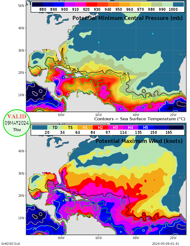
The Maximum Potential Intensity (which was developed by Dr. Emanuel at MIT) for the location of this Invest is <930mb and Cat 4+ -->
Image

... Most storms don't reach their MPI, and only one storm I believe has deepened beyond its MPI (Lili). Wilma strengthened right to her MPI (which was just about 880mb). The MPI incorporates SST data and thermodynamic profiles from the GFS.
0 likes   


Return to “Talkin' Tropics”

Who is online

Users browsing this forum: chaser1 and 18 guests