Ominous image of what will eventually occur on the TX coast

This is the general tropical discussion area. Anyone can take their shot at predicting a storms path.

Moderator: S2k Moderators

Forum rules

The posts in this forum are NOT official forecasts and should not be used as such. They are just the opinion of the poster and may or may not be backed by sound meteorological data. They are NOT endorsed by any professional institution or STORM2K. For official information, please refer to products from the National Hurricane Center and National Weather Service.

Help Support Storm2K
Message
Author
Stratosphere747
Category 5
Category 5
Posts: 3772
Joined: Thu Sep 11, 2003 8:34 pm
Location: Surfside Beach/Freeport Tx
Contact:

#41 Postby Stratosphere747 » Sat May 19, 2007 8:57 am

KatDaddy wrote:Celia produced extreme wind gusts to 185 MPH on the southern Eyewall over SW portions of Corpus. The Corpus NWS recorded 161MPH gust. Give Claudette another 24 hours over the warm GOM and she too would nearing a CAT 4 or CAT 4 at landfall.


Celia was truly a unique storm that still needs more researching. Microbursts/Downbursts seem to be the reasoning behind the extreme gusts seen relative to the sustained winds.

Claudette? While she was intensifying, she was not going thru a RI cycle, so I don't believe another 24hrs would have led to Claudette becoming a 4. Now I am on board with the possibility of Claudette being a 2 upon landfall. The damage surveys conducted by the NWS from both Houston and Corpus Christi still assessed it to be consistent with a 1, so an upgrade is probably unlikely.
0 likes   

Berwick Bay

#42 Postby Berwick Bay » Sat May 19, 2007 9:13 am

Stratosphere747 wrote:
KatDaddy wrote:Celia produced extreme wind gusts to 185 MPH on the southern Eyewall over SW portions of Corpus. The Corpus NWS recorded 161MPH gust. Give Claudette another 24 hours over the warm GOM and she too would nearing a CAT 4 or CAT 4 at landfall.


Celia was truly a unique storm that still needs more researching. Microbursts/Downbursts seem to be the reasoning behind the extreme gusts seen relative to the sustained winds.

Claudette? While she was intensifying, she was not going thru a RI cycle, so I don't believe another 24hrs would have led to Claudette becoming a 4. Now I am on board with the possibility of Claudette being a 2 upon landfall. The damage surveys conducted by the NWS from both Houston and Corpus Christi still assessed it to be consistent with a 1, so an upgrade is probably unlikely.


I like your point about the microbursts in Claudette. Another example of how each storm is unique. So here we go arguing about categories again. I hate to get into that. I guess we need some kind of guide. But this category stuff just isn't cutting it (imho). There are many who could quibble for days on end about hurricanes and their "categories". And look, for the most part we're talking about contemporary storms. So how valid are these categories when related to storms of a hundred years ago? Remember, we have assigned categories to those storms as well. Many are only just now beginning to realize the insufficiencies of this scale. I think that within as little as 5-7 years this scale will be a thing of the past. I'm not sure what they'll come up with though. I really don't see that it enlightens the general public to any great degree either. Seems as though the common sense of the public is beginning to show through. People I talk to (who used to use the category system) don't seem to use it that much anymore. How can you convince someone in Miss. or New Orleans that Katrina (with a 28 foot storm surge) was only a Cat 3? Ridiculous!
0 likes   

Stratosphere747
Category 5
Category 5
Posts: 3772
Joined: Thu Sep 11, 2003 8:34 pm
Location: Surfside Beach/Freeport Tx
Contact:

#43 Postby Stratosphere747 » Sat May 19, 2007 9:28 am

Berwick Bay wrote:
Stratosphere747 wrote:
KatDaddy wrote:Celia produced extreme wind gusts to 185 MPH on the southern Eyewall over SW portions of Corpus. The Corpus NWS recorded 161MPH gust. Give Claudette another 24 hours over the warm GOM and she too would nearing a CAT 4 or CAT 4 at landfall.


Celia was truly a unique storm that still needs more researching. Microbursts/Downbursts seem to be the reasoning behind the extreme gusts seen relative to the sustained winds.

Claudette? While she was intensifying, she was not going thru a RI cycle, so I don't believe another 24hrs would have led to Claudette becoming a 4. Now I am on board with the possibility of Claudette being a 2 upon landfall. The damage surveys conducted by the NWS from both Houston and Corpus Christi still assessed it to be consistent with a 1, so an upgrade is probably unlikely.


I like your point about the microbursts in Claudette. Another example of how each storm is unique. So here we go arguing about categories again. I hate to get into that. I guess we need some kind of guide. But this category stuff just isn't cutting it (imho). There are many who could quibble for days on end about hurricanes and their "categories". And look, for the most part we're talking about contemporary storms. So how valid are these categories when related to storms of a hundred years ago? Remember, we have assigned categories to those storms as well. Many are only just now beginning to realize the insufficiencies of this scale. I think that within as little as 5-7 years this scale will be a thing of the past. I'm not sure what they'll come up with though. I really don't see that it enlightens the general public to any great degree either. Seems as though the common sense of the public is beginning to show through. People I talk to (who used to use the category system) don't seem to use it that much anymore. How can you convince someone in Miss. or New Orleans that Katrina (with a 28 foot storm surge) was only a Cat 3? Ridiculous!


I can't stand the SS scale myself. In fact I detest the use of a 1 min average. The 2005 season was so educational on why the scale and use of categorization is useless, IMO. I just don't think that the NHC and others have had time to catch up and get around to discussions on revamping the system. But for now that is the reference that tropical weather enthusiasts use.
0 likes   

User avatar
KatDaddy
Category 5
Category 5
Posts: 2815
Joined: Mon Oct 21, 2002 6:23 pm
Location: League City, Texas

#44 Postby KatDaddy » Sat May 19, 2007 9:47 am

Yes you are correct. Hobby Airport in southern Harris County recorded sustained winds of 81MPH with a gust of 99MPH in the northern eyewall of Alicia. I was located in Pearland which 16 miles S of Hobby. I estimated we had sustained winds of 80MPH with gusts to 100PH. My estimate turned out be very good. I can tell you one thing. Its quite an experience to see winds that high. You could hear the roar of gusts approaching our yard. The most frightening part of Alicia was knowing the winds were only 80G100MPH. I could not fathom what it would like to experience 130G150MPH or higher. It would be a very tough and scary ride. For a time I thought OMG Rita is the one. It was a surreal couple of days. I could do without a another Rita type threat for the next 20 years.
0 likes   
The following post is NOT an official forecast and should not be used as such. It is just the opinion of the poster and may or may not be backed by sound meteorological data. It is NOT endorsed by any professional institution including storm2k.org For Official Information please refer to the NHC and NWS products.

HurricaneRobert
Category 3
Category 3
Posts: 812
Joined: Fri May 18, 2007 9:31 pm

#45 Postby HurricaneRobert » Sat May 19, 2007 10:33 am

I remember hearing that the damage to DT Houston couldn't be blamed solely on the winds. At the time, many buildings there had ballast roofs which converted into projectiles that broke all the windows. Now Houston has typically had a laissez fair attitude towards the construction industry. I doubt building codes have improved much over the years. They are certainly nothing like those in Florida. I think the damage from the next big storm will the fault of humans, and not from some superstorm that refuses to die over land. How do you know if the damage from Claudette shown in the picture wasn't caused by a tornado?
0 likes   

Derek Ortt

#46 Postby Derek Ortt » Sat May 19, 2007 11:04 am

you don;t want to experience anything over 100 mph

In Katrina, we had gusts between 90-95 mph (I believe that NWS determined that the official gust on the top of my office building was 81KT). We could feel is shaking and I thought we lost the anamometer (went up on the roof to check it out, and got absolutely DRENCHED and soaked to the bone.

Wilma with gusts to about 95-97KT was FAR FAR WORSE. The howl was only interrupted by the sounds of things being torn off of the building. To my north, Lauderdale got it much worse as their SUSTAINED winds were about 100, which caused some structural damage to some of the high rises (winds reached the point where the contents started being sucked out)
0 likes   

Berwick Bay

#47 Postby Berwick Bay » Sat May 19, 2007 12:10 pm

In years gone by I had difficulty finding much good reading material on hurricanes. However, I do remember reading a book published in the '50's (can't remember the name) which I particulary enjoyed. It had a grid which showed typical tropical storm paths for storms within grid boundaries for certain months of the season. For a kid like I was, I found it very instructive. Another thing which I didn't really appreciate at the time was the author's simple classification of what a major storm was, which was winds of at least 100 mph. And you know, the older I get the more truth I find in that. Most people have no idea just how scary, and how much destruction 100 mph winds can wreak upon a given locale. The SS Scale says 115 mph for major. As if 105 or 110 mph is not strong enough. I know it really says 111 mph. But when's the last time you heard an NHC Advisory say winds of 111 mph? They always use the 5 mph increments which means for all intents and purposes the major classification is 115 mph. Anyway, 100 mph is major enough for me.
0 likes   

User avatar
Ptarmigan
Category 5
Category 5
Posts: 5319
Joined: Wed Aug 16, 2006 9:06 pm

#48 Postby Ptarmigan » Sat May 19, 2007 1:47 pm

KatDaddy wrote:Celia produced extreme wind gusts to 185 MPH on the southern Eyewall over SW portions of Corpus. The Corpus NWS recorded 161MPH gust. Give Claudette another 24 hours over the warm GOM and she too would nearing a CAT 4 or CAT 4 at landfall.


Celia was weird that the bad side was on the southern eyewall. I remember Hurricane Chantal of 1989 being that as well. All the heavy rain and high winds were on the southwest side of the hurricane. I remember well when Chantal came. There was strong wind and heavy rain. I wonder why the "dirty" side for Celia and Chantal were on the southern part?
0 likes   

Derek Ortt

#49 Postby Derek Ortt » Sat May 19, 2007 1:53 pm

celia's "dirty" side being the southern side implies easterly shear

The greatest convective activity is downshear left of the shear vector

Same thing happened in Miami with Katrina. The easterly shear was not the strongest, but enough to displace convection (and prevent Katrina from being far worse in Miami
0 likes   

User avatar
wxmann_91
Category 5
Category 5
Posts: 8013
Age: 34
Joined: Fri Jul 15, 2005 2:49 pm
Location: Southern California
Contact:

#50 Postby wxmann_91 » Sat May 19, 2007 2:24 pm

Derek,

Do you mean northerly shear? If it was easterly shear, wouldn't the western side be the strongest?
0 likes   

User avatar
drezee
S2K Supporter
S2K Supporter
Posts: 3664
Joined: Mon Jun 09, 2003 12:49 pm
Location: FL

#51 Postby drezee » Sat May 19, 2007 3:00 pm

Derek Ortt wrote:you don;t want to experience anything over 100 mph

In Katrina, we had gusts between 90-95 mph (I believe that NWS determined that the official gust on the top of my office building was 81KT). We could feel is shaking and I thought we lost the anamometer (went up on the roof to check it out, and got absolutely DRENCHED and soaked to the bone.

Wilma with gusts to about 95-97KT was FAR FAR WORSE. The howl was only interrupted by the sounds of things being torn off of the building. To my north, Lauderdale got it much worse as their SUSTAINED winds were about 100, which caused some structural damage to some of the high rises (winds reached the point where the contents started being sucked out)


I agree. I was in Mobile for Frederick in '79. While the official highest wind gust was 84 kts at the airport. I was S of the airport about halfway between there and Dauphin Island which reported 126kt wind gusts. I would defintely estimate that we recieve gusts to about 95-105 kts. I have never and will never stay for a CAT 3 or above again. EVER!
0 likes   

User avatar
Normandy
Category 5
Category 5
Posts: 2293
Joined: Sun Oct 10, 2004 12:31 am
Location: Houston, TX

#52 Postby Normandy » Sat May 19, 2007 4:50 pm

Stratosphere747 wrote:
KatDaddy wrote:Celia produced extreme wind gusts to 185 MPH on the southern Eyewall over SW portions of Corpus. The Corpus NWS recorded 161MPH gust. Give Claudette another 24 hours over the warm GOM and she too would nearing a CAT 4 or CAT 4 at landfall.


Celia was truly a unique storm that still needs more researching. Microbursts/Downbursts seem to be the reasoning behind the extreme gusts seen relative to the sustained winds.

Claudette? While she was intensifying, she was not going thru a RI cycle, so I don't believe another 24hrs would have led to Claudette becoming a 4. Now I am on board with the possibility of Claudette being a 2 upon landfall. The damage surveys conducted by the NWS from both Houston and Corpus Christi still assessed it to be consistent with a 1, so an upgrade is probably unlikely.


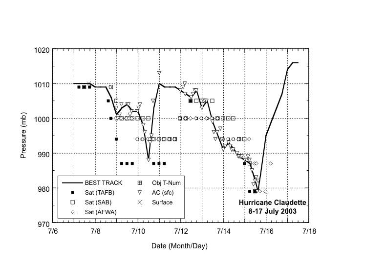
Claudette was acually undergoing a RI cycle. Look at the radar loop as the hurricane approached the coast, and look at how quickly it spun up and got organized.
0 likes   

User avatar
drezee
S2K Supporter
S2K Supporter
Posts: 3664
Joined: Mon Jun 09, 2003 12:49 pm
Location: FL

#53 Postby drezee » Sat May 19, 2007 4:59 pm

Claudette was not going through RI at landfall...


Image
0 likes   

Derek Ortt

#54 Postby Derek Ortt » Sat May 19, 2007 5:08 pm

easterly shear would imply that the south quad is the most intense in a TC

read Black et al. (2002). It describes why the greatest convective activity is downhear and LEFT of the shear vector
0 likes   

User avatar
Sjones
Tropical Storm
Tropical Storm
Posts: 168
Joined: Thu May 17, 2007 2:09 pm
Location: Southeast Texas

#55 Postby Sjones » Sat May 19, 2007 5:22 pm

Hello All! Newbie here! Fired up and ready for the new season!!! :)
0 likes   

User avatar
drezee
S2K Supporter
S2K Supporter
Posts: 3664
Joined: Mon Jun 09, 2003 12:49 pm
Location: FL

#56 Postby drezee » Sat May 19, 2007 5:25 pm

Welcome to Storm2K.
0 likes   

JonathanBelles
Professional-Met
Professional-Met
Posts: 11430
Age: 35
Joined: Sat Dec 24, 2005 9:00 pm
Location: School: Florida State University (Tallahassee, FL) Home: St. Petersburg, Florida
Contact:

#57 Postby JonathanBelles » Sat May 19, 2007 5:26 pm

Welcome Sjones!!
0 likes   

User avatar
Sjones
Tropical Storm
Tropical Storm
Posts: 168
Joined: Thu May 17, 2007 2:09 pm
Location: Southeast Texas

#58 Postby Sjones » Sat May 19, 2007 5:37 pm

Thanks for the kind hopitality! :wink:
0 likes   

Berwick Bay

#59 Postby Berwick Bay » Sun May 20, 2007 6:48 am

What I remember about Claudette.

Claudette had a definite circulation well east of the Lesser Antilles. This was unusual for a July storm. However, the circulation was more of the mid-level variety and the NHC hesistated to upgrade her to Depression status. That year (was it '03?) there were several systems which had mid-level circulations which could easily be construed as low level judging only from satellite photos. Claudette continued on across the Carribean finally being upgraded to tropical storm status there. However, it remained poorly organized and even weakened as it entered the southern Gulf. Only at the end of her long odyssey across the tropics did Claudette begin to gather herself just south of La. on a WNW course toward the central Texas course. She was finally upgraded to hurricane status in the early morning hours before landfall. It does seem as though Claudette was in something or a rapid intensification as it made landfall with winds in the 85-90 mph range, when only a very few hours before it was a poorly organized tropical storm. One footnote, Claudette was a name that had been used previously by a tropical storm which struck the same part of the Texas Coast as a tremendous rainmaker bringing forty inches of rain to Texas in 1979. Which is why I don't like this naming cycle which brings the same names up ever six years.

Back to top
0 likes   

User avatar
Sjones
Tropical Storm
Tropical Storm
Posts: 168
Joined: Thu May 17, 2007 2:09 pm
Location: Southeast Texas

#60 Postby Sjones » Sun May 20, 2007 8:59 pm

Wonder what the chances are of Southeast Texas being impacted with another hurricane... :?: :?: :?: :?:
0 likes   


Return to “Talkin' Tropics”

Who is online

Users browsing this forum: Cpv17, Google Adsense [Bot], Hurricaneman, Pelicane, Stratton23 and 36 guests