
Wow, that mid-level circulation is very impressive, can't really miss that can you!
i wonder whether the current -ve NAO conditions are helping to sustain stronger waves, as the Azores high has been weaker then normal, I'm pretty confident of this and a weaker will mean less dust will be dragged out to sea would it not (bar off course to the north of well developed waves.)
African wave IS a player - 93L Invest
Moderator: S2k Moderators
Forum rules

The posts in this forum are NOT official forecasts and should not be used as such. They are just the opinion of the poster and may or may not be backed by sound meteorological data. They are NOT endorsed by any professional institution or STORM2K. For official information, please refer to products from the National Hurricane Center and National Weather Service.
0 likes
Personal Forecast Disclaimer:
The posts in this forum are NOT official forecast and should not be used as such. They are just the opinion of the poster and may or may not be backed by sound meteorological data. They are NOT endorsed by any professional institution or storm2k.org. For official information, please refer to the NHC and NWS products
The posts in this forum are NOT official forecast and should not be used as such. They are just the opinion of the poster and may or may not be backed by sound meteorological data. They are NOT endorsed by any professional institution or storm2k.org. For official information, please refer to the NHC and NWS products

-
PTrackerLA

- Category 5

- Posts: 5281
- Age: 42
- Joined: Thu Oct 10, 2002 8:40 pm
- Location: Lafayette, LA


-
Tampa Bay Hurricane

- Category 5
- Posts: 5598
- Age: 38
- Joined: Fri Jul 22, 2005 7:54 pm
- Location: St. Petersburg, FL
-
Weatherfreak000
It's allready "poofing" guys, it's completely devoid of deep convection now.
The only positive thing I note from the latest sat pic it appears to maybe have gained a degree of latitude. In this case the MLC could possibly break away from the ITCZ.
Until then, i'm thinking the entire wave axis is gonna fall apart and we're gonna be remembering the wave that we first had fondly, and probably be ready to move on.
0 likes
I don't think it has to be watched now (though if it does have a LLC right now then I suppose a outside shot at a TD if it can keep some sort of decent convection, though unlikely.) ...but like 05 once the waves got further west many developed. It seemed we had very well developed waves coming off Africa in June and July but we had to wait till they reached the Caribbean for them to develop, I suspect the same could happen this time given the heat content in the Caribbean is high.
0 likes
From 2000
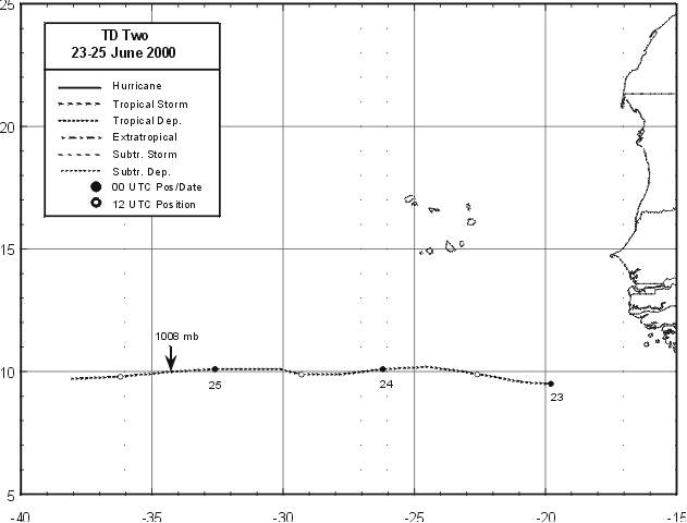
Tropical Depression Two formed from a tropical wave on 23 June, soon after moving from Africa to the far eastern tropical Atlantic Ocean and while centered a little over 300 nautical miles southeast of the Cape Verde Islands. The depression moved due westward at 15 to 20 knots for nearly three days and weakened to an open wave on the 25th in the central tropical Atlantic. Scatterometer surface wind data suggests that the depression may have been close to tropical storm strength for a short period on the 23rd.
http://www.nhc.noaa.gov/prelims/2000two1.gif
Last edited by drezee on Sat Jun 09, 2007 3:25 pm, edited 1 time in total.
0 likes
-
Matt-hurricanewatcher
Re: Cape Verde in JUNE?
philnyc wrote:drezee wrote:wzrgirl1 wrote:drezee wrote:wzrgirl1 wrote:with that said....has a cape verde system ever made it all the way across and affect the CONU so early in the season?
Hi wzrgirl1,
Here is an excerpt from the NHC Hurricane season summary for the 2003 season:
SHORT-LIVED TROPICAL DEPRESSION TWO DEVELOPED IN THE TROPICAL
ATLANTIC ON JUNE 10TH...ONLY THE THIRD TROPICAL CYCLONE TO FORM TO
THE EAST OF THE LESSER ANTILLES IN JUNE SINCE 1967. IT MOVED
RAPIDLY WESTWARD AND DEGENERATED INTO A TROPICAL WAVE ONE DAY AFTER
IT FORMED.
And it doesn't say how far east it formed. You'd have to look further. But I would guess that no easterly wave coming off of Africa in June became a hurricane until near the Antilles, if one ever did. It would have to move west-northwest as well; the eastern Caribbean usually has very high westerly wind shear at this time of year that would rip it apart.

0 likes


Perhaps, though I find it unlikely, this wave can redevelop some convection in the upcoming days. The water is conceivably warm enough, given the low latitude of the wave. I wonder, though, whether the two waves in june that became short lived tropical depressions (in 2000 and 2003) died off their convection upon hitting the water, and reformed it later, or whether their convective structure remained relatively intact.
0 likes

000
ABNT20 KNHC 092100
TWOAT
TROPICAL WEATHER OUTLOOK
NWS TPC/NATIONAL HURRICANE CENTER MIAMI FL
530 PM EDT SAT JUN 9 2007
FOR THE NORTH ATLANTIC...CARIBBEAN SEA AND THE GULF OF MEXICO...
A LARGE TROPICAL WAVE...LOCATED JUST OFFSHORE OF WEST AFRICA...IS
MOVING WESTWARD AT 15 TO 20 MPH. ASSOCIATED THUNDERSTORM ACTIVITY
IS MINIMAL... AND ENVIRONMENTAL CONDITIONS ARE NOT FAVORABLE FOR
FURTHER DEVELOPMENT.
ELSEWHERE...TROPICAL CYCLONE FORMATION IS NOT EXPECTED DURING THE
NEXT 48 HOURS.
$$
FORECASTER BLAKE
0 likes

-
AtlanticWind

- S2K Supporter

- Posts: 1898
- Age: 67
- Joined: Sun Aug 08, 2004 9:57 pm
- Location: Plantation,Fla
http://www.esl.lsu.edu/webpics/goes/Sto ... est_ir.jpg At 4pm still looking pretty good. History is not on its side though.
0 likes
What would you prefer to call it? Nothing really needs to be said about these systems besides they are all doomed for atleast another few weeks. The ocean can't sustain the convection, so they go "poof". How about dissipate, would that be better?SaveNola wrote:Shame to have such insightful intelligent commentary constantly dumbed down by the word 'poof'. How about we call Tropical Storms, "big white fluffy spinny things".
0 likes
-
HURAKAN

- Professional-Met

- Posts: 46086
- Age: 38
- Joined: Thu May 20, 2004 4:34 pm
- Location: Key West, FL
- Contact:
SaveNola wrote:Shame to have such insightful intelligent commentary constantly dumbed down by the word 'poof'. How about we call Tropical Storms, "big white fluffy spinny things".
The convective pattern of the tropical wave just off the coast of Africa has been deteriorating over the past few hours indicating that convergence at the low levels is minimal at best. The presentation on the visible of the system is still impressive, nonetheless, it seems that the cool sea-surface temperaturas and marginal environmental conditions have worked together against the strenght of the tropical wave.
Is that better?
0 likes
-
Opal storm
Who is online
Users browsing this forum: No registered users and 33 guests