Wave in Eastern Atlantic
Moderator: S2k Moderators
Forum rules
The posts in this forum are NOT official forecasts and should not be used as such. They are just the opinion of the poster and may or may not be backed by sound meteorological data. They are NOT endorsed by any professional institution or STORM2K. For official information, please refer to products from the National Hurricane Center and National Weather Service.
- windstorm99
- S2K Supporter

- Posts: 1578
- Age: 48
- Joined: Sat May 26, 2007 8:10 am
- Location: Miami, Florida
- Contact:
Re: Wave in Eastern Atlantic
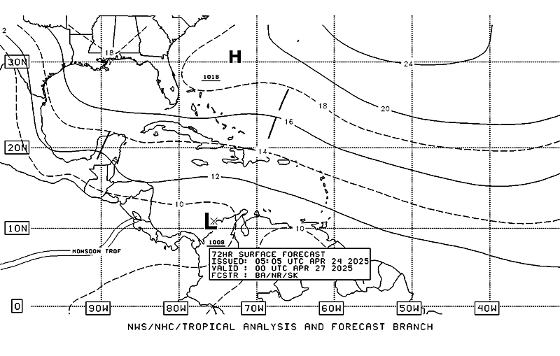
Future track of this wave on the current 72hr surface map agreeing with the 12z GFS?Maybe.


0 likes
- 'CaneFreak
- Category 5

- Posts: 1487
- Joined: Mon Jun 05, 2006 10:50 am
- Location: New Bern, NC
Re: Wave in Eastern Atlantic
cycloneye wrote:
Look at 9n-34w where the barbs are turning in a weak circule.Is a weak circulation at this time.
Are those weak westerly winds I see on the south side of the circulation? I think so...HMMMMMMMMMMMMM....seems as though this may get some attention over the next several days.
0 likes
-
Zardoz
- Category 1

- Posts: 309
- Joined: Fri Aug 25, 2006 9:48 am
- Location: Severe weather-challenged Southern California
Re: Wave in Eastern Atlantic
0 likes
-
tolakram
- Admin

- Posts: 20168
- Age: 62
- Joined: Sun Aug 27, 2006 8:23 pm
- Location: Florence, KY (name is Mark)
Re: Wave in Eastern Atlantic
I think the key here is the low level circulation. Like I asked before, what was the last wave to have a LLC that did not develop? The previous waves did not have this kind of signature on quikscat. Quikscat just reads the winds, it doesn't -find- things. 
In my opinion the fairly consistent convection and the circulation evident on quikscat indicates this thing has a fair chance to develop.
In my opinion the fairly consistent convection and the circulation evident on quikscat indicates this thing has a fair chance to develop.
0 likes
- GeneratorPower
- S2K Supporter

- Posts: 1648
- Age: 46
- Joined: Sun Dec 18, 2005 11:48 pm
- Location: Huntsville, AL
- gatorcane
- S2K Supporter

- Posts: 23703
- Age: 47
- Joined: Sun Mar 13, 2005 3:54 pm
- Location: Boca Raton, FL
Re: Wave in Eastern Atlantic
oh boy...all those season cancel posters may be eating crow after this invest.
I do say it is a go also. You can see some deeper convection trying to build near the "LLC"...
Here we go...
I do say it is a go also. You can see some deeper convection trying to build near the "LLC"...
Here we go...
0 likes
- skysummit
- S2K Supporter

- Posts: 5305
- Age: 50
- Joined: Tue Aug 31, 2004 11:09 pm
- Location: Ponchatoula, LA
- Contact:
Re: Wave in Eastern Atlantic
gatorcane wrote:oh boy...all those season cancel posters may be eating crow after this invest.
I do say it is a go also. You can see some deeper convection trying to build near the "LLC"...
Here we go...
Season Cancel posts??? Wait...no one HERE said that, did they? LOL
0 likes
- AtlanticWind
- S2K Supporter

- Posts: 1898
- Age: 67
- Joined: Sun Aug 08, 2004 9:57 pm
- Location: Plantation,Fla
Re:
GeneratorPower wrote:This one is probably a "go". Just going with climo here, you will probably see some attention focused here in the next few days.
I agree , A healthy wave coming into the peak of season with low shear has a very good chance
0 likes
- GeneratorPower
- S2K Supporter

- Posts: 1648
- Age: 46
- Joined: Sun Dec 18, 2005 11:48 pm
- Location: Huntsville, AL
- skysummit
- S2K Supporter

- Posts: 5305
- Age: 50
- Joined: Tue Aug 31, 2004 11:09 pm
- Location: Ponchatoula, LA
- Contact:
Re:
GeneratorPower wrote:The steering current setup is going to be different with this one, for sure. The high pressure that has been a permanent feature over the SE US is breaking.
You're right. I was just about to post something along those lines. The "heat dome" is falling apart. I don't see this one being a low lat, west runner....that's IF it develops (which I believe it will).
0 likes
- windstorm99
- S2K Supporter

- Posts: 1578
- Age: 48
- Joined: Sat May 26, 2007 8:10 am
- Location: Miami, Florida
- Contact:
Re:
GeneratorPower wrote:The steering current setup is going to be different with this one, for sure. The high pressure that has been a permanent feature over the SE US is breaking.
Any Promets thoughts on steering currents the next 3-5 days?
0 likes
- gatorcane
- S2K Supporter

- Posts: 23703
- Age: 47
- Joined: Sun Mar 13, 2005 3:54 pm
- Location: Boca Raton, FL
Re: Re:
windstorm99 wrote:GeneratorPower wrote:The steering current setup is going to be different with this one, for sure. The high pressure that has been a permanent feature over the SE US is breaking.
Any Promets thoughts on steering currents the next 3-5 days?
I will say it is unlikely we would see another westrunner similar to Dean. In my opinion, that was a rare situation for a Aug. A system that strong usually finds a weakness somewhere
0 likes
- GeneratorPower
- S2K Supporter

- Posts: 1648
- Age: 46
- Joined: Sun Dec 18, 2005 11:48 pm
- Location: Huntsville, AL
Gatorcane, yes it was a rare situation. Mike Watkins explained that a west running track had happened only one time previously in over 100 years. That was in 1912, I believe. Dean took an absolutely incredible, oddball track climatologically speaking.
Just look at the CLIPPER (climo-only) model projections for Dean. (Sorry, don't have link.)
Just look at the CLIPPER (climo-only) model projections for Dean. (Sorry, don't have link.)
0 likes
- gatorcane
- S2K Supporter

- Posts: 23703
- Age: 47
- Joined: Sun Mar 13, 2005 3:54 pm
- Location: Boca Raton, FL
Re: Wave in Eastern Atlantic=Latest Quickscat in page 2
the strong wave is being steered by a strong ridge of high pressure to the north. So it will go west for the next several days. After that the situation becomes more unclear.....based on the current setup it would take similar track to Dean. But the likelyhood of this steering setup maintaining for another 10-14 days is very small in my opinion.

0 likes
-
Derek Ortt
- GeneratorPower
- S2K Supporter

- Posts: 1648
- Age: 46
- Joined: Sun Dec 18, 2005 11:48 pm
- Location: Huntsville, AL
- skysummit
- S2K Supporter

- Posts: 5305
- Age: 50
- Joined: Tue Aug 31, 2004 11:09 pm
- Location: Ponchatoula, LA
- Contact:
Re:
Derek Ortt wrote:steering looks primarily west to WNW, probably a little north of Dean and more toward the northern Islands
Yea, Luis...this one is one you may TRULY need to keep an eye on.
0 likes
- ConvergenceZone
- Category 5

- Posts: 5241
- Joined: Fri Jul 29, 2005 1:40 am
- Location: Northern California
Re: Re:
skysummit wrote:GeneratorPower wrote:The steering current setup is going to be different with this one, for sure. The high pressure that has been a permanent feature over the SE US is breaking.
You're right. I was just about to post something along those lines. The "heat dome" is falling apart. I don't see this one being a low lat, west runner....that's IF it develops (which I believe it will).
Does that mean this will be a fish?
0 likes
- windstorm99
- S2K Supporter

- Posts: 1578
- Age: 48
- Joined: Sat May 26, 2007 8:10 am
- Location: Miami, Florida
- Contact:
Re:
Derek Ortt wrote:steering looks primarily west to WNW, probably a little north of Dean and more toward the northern Islands
Thanks Derek! Not what i wanted to here for south florida but of course its still very early in the ball game if theres one out there at all in the coming days.
0 likes
Who is online
Users browsing this forum: No registered users and 29 guests


