Wave East of Windward Islands
Moderator: S2k Moderators
Forum rules

The posts in this forum are NOT official forecasts and should not be used as such. They are just the opinion of the poster and may or may not be backed by sound meteorological data. They are NOT endorsed by any professional institution or STORM2K. For official information, please refer to products from the National Hurricane Center and National Weather Service.
Re: Wave East of Windward Islands
Dryness or not, looks like something is trying to spin up around 9.5N-53W.
0 likes

Re: Wave East of Windward Islands
I have to agree with you Sanibel. You can see some tight turning.
0 likes
-
Brent
- S2K Supporter

- Posts: 38729
- Age: 37
- Joined: Sun May 16, 2004 10:30 pm
- Location: Tulsa Oklahoma
- Contact:
Re: Wave East of Windward Islands
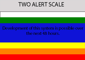
5:30pm TWO:
THE AREA OF DISTURBED WEATHER CENTERED ABOUT 900 MILES EAST OF THE
WINDWARD ISLANDS IS ASSOCIATED WITH A WESTWARD MOVING TROPICAL
WAVE. THERE ARE SOME INDICATIONS THAT THE SYSTEM HAS BECOME A
LITTLE BETTER ORGANIZED THIS AFTERNOON BUT ADDITIONAL
DEVELOPMENT...IF ANY...SHOULD BE SLOW TO OCCUR.
THE AREA OF DISTURBED WEATHER CENTERED ABOUT 900 MILES EAST OF THE
WINDWARD ISLANDS IS ASSOCIATED WITH A WESTWARD MOVING TROPICAL
WAVE. THERE ARE SOME INDICATIONS THAT THE SYSTEM HAS BECOME A
LITTLE BETTER ORGANIZED THIS AFTERNOON BUT ADDITIONAL
DEVELOPMENT...IF ANY...SHOULD BE SLOW TO OCCUR.
0 likes
Re: Wave East of Windward Islands
What is the matter with Noa ssd satellites photos and animation??Does'ny work since yersterday!!!
0 likes
-
Brent
- S2K Supporter
- Posts: 38729
- Age: 37
- Joined: Sun May 16, 2004 10:30 pm
- Location: Tulsa Oklahoma
- Contact:
Re: Wave East of Windward Islands
HUC wrote:What is the matter with Noa ssd satellites photos and animation??Does'ny work since yersterday!!!
Try this one:
http://www.ssd.noaa.gov/goes/east/catl/avn-l.jpg
0 likes
Re: Wave East of Windward Islands
Thank's Brent,and hope the atlantic wide view will work soon,because of the 5 disturb areas......
0 likes
-
CYCLONE MIKE
- Category 5

- Posts: 2183
- Joined: Tue Aug 31, 2004 6:04 pm
- Location: Gonzales, LA
Western Atlantic east of islands
I am normally not a blod watcher, but look at the disturbance near 10n 55w. It caught my attention while watching the loops of the sw carib invest. Looks to have some kind of turning starting to develop. Have not heard of any interest in this area. Just caught my eyes, maybe nothing.
0 likes
-
cycloneye

- Admin

- Posts: 149275
- Age: 69
- Joined: Thu Oct 10, 2002 10:54 am
- Location: San Juan, Puerto Rico
Re: Western Atlantic east of islands
CYCLONE MIKE wrote:I am normally not a blod watcher, but look at the disturbance near 10n 55w. It caught my attention while watching the loops of the sw carib invest. Looks to have some kind of turning starting to develop. Have not heard of any interest in this area. Just caught my eyes, maybe nothing.
I merged your post with this thread as the discussions about that system are going on here.
0 likes
-
CYCLONE MIKE
- Category 5
- Posts: 2183
- Joined: Tue Aug 31, 2004 6:04 pm
- Location: Gonzales, LA
Re: Wave East of Windward Islands
Appreciate it cycloneye. Never even saw this thread. What do you think of this area?
0 likes
-
cycloneye
- Admin
- Posts: 149275
- Age: 69
- Joined: Thu Oct 10, 2002 10:54 am
- Location: San Juan, Puerto Rico
Re: Wave East of Windward Islands
CYCLONE MIKE wrote:Appreciate it cycloneye. Never even saw this thread. What do you think of this area?
It has a chance to sneak below the unfavorable upper winds to the north and develop.Time will tell.
0 likes
-
cycloneye
- Admin
- Posts: 149275
- Age: 69
- Joined: Thu Oct 10, 2002 10:54 am
- Location: San Juan, Puerto Rico
Re: Wave East of Windward Islands

More convection building in the area.I would not be surprised to see an invest tagged to this one if trend of organization continues.
0 likes


Re: Wave East of Windward Islands
has anybody checked out stormW's forecast in the tropical analysis forum. He updates the same thread daily. He is watching this area and also thinks Oct. may be busy.
0 likes
-
HURAKAN

- Professional-Met

- Posts: 46084
- Age: 39
- Joined: Thu May 20, 2004 4:34 pm
- Location: Key West, FL
- Contact:
TWD 805:
AN ATLANTIC OCEAN TROPICAL WAVE IS ALONG 46W SOUTH OF 16N MOVING
WEST 10-15 KT. WELL DEFINED LOW LEVEL CYCLONIC TURNING IS NOTED
ON SATELLITE IMAGERY. AN EMBEDDED LOW LEVEL SWIRL IS NE OF THE
MAIN AXIS NEAR 14N43W THAT MAY DEVELOP INTO A SEPARATE LOW IN
THE FUTURE. CONVECTION IS AGAIN MOSTLY CONFINED TO THE ITCZ.
WIDELY SCATTERED MODERATE CONVECTION IS FROM 8N-11N BETWEEN
44W-49W.
0 likes

Re: Wave East of Windward Islands
Another low rider almost invest worthy? This one has some running room if it clears South America.
0 likes
-
HurricaneMaster_PR

- Category 2

- Posts: 795
- Joined: Tue Jul 22, 2003 6:23 pm
- Location: San Juan, Puerto Rico
Re: Wave East of Windward Islands
TROPICAL WEATHER OUTLOOK
NWS TPC/NATIONAL HURRICANE CENTER MIAMI FL
1030 PM EDT SAT SEP 22 2007
FOR THE NORTH ATLANTIC...CARIBBEAN SEA AND THE GULF OF MEXICO...
THE BROAD AREA OF LOW PRESSURE OVER THE NORTHWESTERN CARIBBEAN SEA
AND THE YUCATAN PENINSULA HAS CHANGED LITTLE IN ORGANIZATION DURING
THE PAST FEW HOURS...AND CONTINUES TO BE ACCOMPANIED BY A LARGE
AREA OF CLOUDINESS AND THUNDERSTORMS. UPPER-LEVEL WINDS
ARE FAVORABLE FOR SOME DEVELOPMENT WHEN THE LOW EMERGES
OVER THE GULF OF MEXICO WITHIN THE NEXT 24 HOURS.
SATELLITE IMAGES INDICATE THAT THE NON-TROPICAL LOW LOCATED ABOUT
850 MILES WEST-SOUTHWEST OF THE AZORES IS ON THE VERGE OF BECOMING
A SUBTROPICAL OR TROPICAL CYCLONE. LITTLE MOTION IS EXPECTED
DURING THE NEXT 12 TO 24 HOURS...BUT THEREAFTER...THE SYSTEM SHOULD
BEGIN TO MOVE TOWARD THE NORTHEAST OVER THE OPEN ATLANTIC.
SHOWERS AND THUNDERSTORMS ASSOCIATED WITH A WESTWARD MOVING TROPICAL
WAVE HAVE BECOME MORE CONCENTRATED ABOUT 550 MILES EAST OF THE
WINDWARD ISLANDS. THERE ARE SOME INDICATIONS THAT THE SYSTEM IS
BECOMING A LITTLE BETTER ORGANIZED BUT ADDITIONAL DEVELOPMENT...IF
ANY...SHOULD BE SLOW TO OCCUR.
THE BROAD AREA OF LOW PRESSURE PASSING ABOUT 550 MILES SOUTH OF THE
CAPE VERDE ISLANDS REMAINS WELL-ORGANIZED. THIS SYSTEM HAS THE
POTENTIAL TO BECOME A TROPICAL DEPRESSION AS IT MOVES WESTWARD AT
15 MPH DURING THE NEXT FEW DAYS.
THE AREA OF CLOUDINESS AND THUNDERSTORMS EXTENDING FROM NORTHEAST OF
THE LEEWARD ISLANDS NORTHEASTWARD ACROSS THE ATLANTIC FOR SEVERAL
HUNDRED MILES REMAINS DISORGANIZED. UPPER-LEVEL WINDS ARE HIGHLY
UNFAVORABLE FOR DEVELOPMENT.
ELSEWHERE...TROPICAL CYCLONE FORMATION IS NOT EXPECTED DURING THE
NEXT 48 HOURS.
$$
FORECASTER AVILA/BLAKE
0 likes
Re: Wave East of Windward Islands
Need visible on this one to see what kind of spin exists if any.
0 likes
Who is online
Users browsing this forum: Majestic-12 [Bot] and 126 guests