
TROPICAL WEATHER DISCUSSION
NWS TPC/NATIONAL HURRICANE CENTER MIAMI FL
705 PM EST THU DEC 27 2007
THE ATLANTIC OCEAN...
OF INTEREST IS THE DEEP CYCLONE CENTERED NEAR 26N38W. THIS
SYSTEM HAS REMAINED STATIONARY FOR A COUPLE OF DAYS AND
ORGANIZED CONVECTION IS STARTING TO DEVELOP. QUIKSCAT WINDS
SUGGEST THAT THERE ARE SOME GALE FORCE WINDS ALONG THE NORTHERN
SEMI-CIRCLE OF THE SYSTEM...BUT THERE MAY BE SOME RAIN
CONTAMINATION IN THE OBSERVED WINDS. THE MAIN BAROCLINIC ZONE
REMAINS WELL TO THE NORTH OF THE SYSTEM AND ITS FRONTAL
STRUCTURE HAS TRANSITIONED TO A WEAK TRAILING TROUGH. THE FSU
CYCLONE PHASE SPACE ANALYSES INDICATED THAT THE CYCLONE MAY BE
BECOMING A HYBRID SYSTEM...BUT UNTIL MORE SYMMETRIC DEEP
CONVECTION DEVELOPS IT WILL CONTINUE TO BE CONSIDERED AN
OCCLUDED LOW. VERTICAL SHEAR ON THE SYSTEM IS RELATIVELY WEAK
AS THE UPPER PORTION OF THE CYCLONE IS DISPLACED SOMEWHAT
NORTHWEST OF THE SURFACE CIRCULATION. THIS LOW-MODERATE SHEAR
ENVIRONMENT MAY ONLY LAST FOR ANOTHER DAY OR SO BEFORE STRONG
UPPER WESTERLIES IMPACT THE SYSTEM WITH THE APPROACH OF A
VIGOROUS SHORT-WAVE TROUGH. THE CYCLONE SHOULD MEANDER IN PLACE
FOR THE NEXT TWO DAYS BEFORE MOVING OFF SLOWLY TO THE WEST OR
SOUTHWEST.
One last hurrah - pulling a Zeta? E. Atlantic
Moderator: S2k Moderators
Forum rules

The posts in this forum are NOT official forecasts and should not be used as such. They are just the opinion of the poster and may or may not be backed by sound meteorological data. They are NOT endorsed by any professional institution or STORM2K. For official information, please refer to products from the National Hurricane Center and National Weather Service.
-
P.K.

- Professional-Met

- Posts: 5149
- Joined: Thu Sep 23, 2004 5:57 pm
- Location: Watford, England
- Contact:
Re: One last hurrah - pulling a Zeta? (E. Atlantic)
KNES have picked up on this system.
28/2345 UTC 25.9N 38.2W ST1.5/1.5 90L -- Atlantic Ocean
28/2345 UTC 25.9N 38.2W ST1.5/1.5 90L -- Atlantic Ocean
0 likes

-
CrazyC83
- Professional-Met
- Posts: 34315
- Joined: Tue Mar 07, 2006 11:57 pm
- Location: Deep South, for the first time!
Re: One last hurrah - pulling a Zeta? (E. Atlantic)
WOW! Should be Invest 95L soon, at least...
0 likes
-
Coredesat
-
CrazyC83
- Professional-Met
- Posts: 34315
- Joined: Tue Mar 07, 2006 11:57 pm
- Location: Deep South, for the first time!
Re:
Coredesat wrote:It's listed on the floater page as 90L; however, this shouldn't be moved to Active Storms until it appears on NRL (it is still 2007, so it should be 95L, not 90L).
Yep I agree, they probably have that as a temporary designation since they want it up but haven't fully declared it yet.
It's not an "official" invest until it is on NRL, and yep it should be 95L.
0 likes
-
cycloneye

- Admin

- Posts: 149275
- Age: 69
- Joined: Thu Oct 10, 2002 10:54 am
- Location: San Juan, Puerto Rico
Re: One last hurrah - pulling a Zeta? (E. Atlantic)
If this turns out to be classified,the question is when,because the race will be on between Arthur and Pablo to see which will be the name before or after the ball drops.
0 likes
-
Aric Dunn
- Category 5

- Posts: 21238
- Age: 43
- Joined: Sun Sep 19, 2004 9:58 pm
- Location: Ready for the Chase.
- Contact:
Re: One last hurrah - pulling a Zeta? (E. Atlantic)
cycloneye wrote:If this turns out to be classified,the question is when,because the race will be on between Arthur and Pablo to see which will be the name before or after the ball drops.
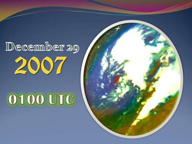
well considering it will be the 29th tomorrow and a WSW to SW motion will bring strong shear in two days .. if it has not developed by then it probably wont but if the shear does not increase it may be a round a while
0 likes


-
CrazyC83
- Professional-Met
- Posts: 34315
- Joined: Tue Mar 07, 2006 11:57 pm
- Location: Deep South, for the first time!
I don't know if they have a set protocol for a 2007 depression becoming a storm in 2008. IMO, if it becomes TD18 on December 31, it should remain part of the 2007 season no matter what and should become Pablo if it reaches storm strength after the ball drops.
That way, it will be recognized in name as a 2007 storm (as it is numbered as 2007), and if post-analysis determines it becomes a storm earlier, it won't have the Alice issue.
That way, it will be recognized in name as a 2007 storm (as it is numbered as 2007), and if post-analysis determines it becomes a storm earlier, it won't have the Alice issue.
0 likes


-
feederband

- S2K Supporter

- Posts: 3423
- Joined: Wed Oct 01, 2003 6:21 pm
- Location: Lakeland Fl

Re:
Chacor wrote:The point made earlier in the thread also seems very relevant, as we haven't had this problem before. If we get TD (or SubTD) 18 on 31 December and it's not named until the new year, do you still name it Pablo as the number is 18, and not 1?
I'm pretty sure it would be Pablo in that situation. But who would love to see Arthur on January 1? I know I would.
0 likes
-
JonathanBelles
- Professional-Met
- Posts: 11430
- Age: 35
- Joined: Sat Dec 24, 2005 9:00 pm
- Location: School: Florida State University (Tallahassee, FL) Home: St. Petersburg, Florida
- Contact:
-
cycloneye
- Admin
- Posts: 149275
- Age: 69
- Joined: Thu Oct 10, 2002 10:54 am
- Location: San Juan, Puerto Rico
Re: One last hurrah - pulling a Zeta? (E. Atlantic)
But who would love to see Arthur on January 1? I know I would.
If that happens,then everyone starts with one before the official poll starts on March 15.
0 likes
Who is online
Users browsing this forum: dexterlabio and 118 guests