Seasonal Indicators (Beyond Day 16): Instability / SST's / MSLP / Steering / Sal
Moderator: S2k Moderators
Forum rules

The posts in this forum are NOT official forecasts and should not be used as such. They are just the opinion of the poster and may or may not be backed by sound meteorological data. They are NOT endorsed by any professional institution or STORM2K. For official information, please refer to products from the National Hurricane Center and National Weather Service.
-
SFLcane

- S2K Supporter

- Posts: 10281
- Age: 48
- Joined: Sat Jun 05, 2010 1:44 pm
- Location: Lake Worth Florida
Re: 2016 indicators: Instability / SST's / MSLP / Steering / Sal
ECMWF Seasonal Model Atlantic Hurricane Forecast Update: Including Alex, now is predicting 13 Named Storms; 9 Hurricanes; 3 Major Hurricanes.
0 likes
-
tarheelprogrammer

- S2K Supporter
- Posts: 1793
- Joined: Mon Mar 28, 2016 9:25 pm
- Location: Raleigh, NC area (Garner, NC)
Re: 2016 indicators: Instability / SST's / MSLP / Steering / Sal
Is that a tropical wave already just northeast of the South American continent? Looks disorganized but very similar to one. It has almost no chance to survive shear I think (not a forecast) but Is this common this time of year if it is one?
0 likes
My posts are not official forecasts. They are just my opinion and may or may not be backed by sound meteorological data. They are NOT endorsed by any professional institution or storm2k.org. For official information, please refer to the NHC and NWS products.

Re: 2016 indicators: Instability / SST's / MSLP / Steering / Sal

0 likes
The following post is NOT an official forecast and should not be used as such. It is just the opinion of the poster and may or may not be backed by sound meteorological data. It is NOT endorsed by any professional institution including storm2k.org For Official Information please refer to the NHC and NWS products.
-
SFLcane
- S2K Supporter
- Posts: 10281
- Age: 48
- Joined: Sat Jun 05, 2010 1:44 pm
- Location: Lake Worth Florida
Re: 2016 indicators: Instability / SST's / MSLP / Steering / Sal
Thx for UKMET.. look a rather wet Caribbean and mdr. Me likes
0 likes

Re: 2016 indicators: Instability / SST's / MSLP / Steering / Sal
One thing that I noticed about the UKMET is that it trended wetter for the Caribbean and parts of the Atlantic MDR for JJA.
0 likes
-
tolakram
- Admin

- Posts: 20185
- Age: 62
- Joined: Sun Aug 27, 2006 8:23 pm
- Location: Florence, KY (name is Mark)
Re: 2016 indicators: Instability / SST's / MSLP / Steering / Sal
Last year some of us discussed the ongoing drought in Brazil and the effects, if any, on the RH of the tropical Atlantic. The drought ended in February with reservoir levels nearly doubling so I wonder if this will have a positive impact?
0 likes
M a r k
- - - - -
Join us in chat: Storm2K Chatroom Invite. Android and IOS apps also available.
The posts in this forum are NOT official forecasts and should not be used as such. Posts are NOT endorsed by any professional institution or STORM2K.org. For official information and forecasts, please refer to NHC and NWS products.
-
PTrackerLA

- Category 5

- Posts: 5281
- Age: 42
- Joined: Thu Oct 10, 2002 8:40 pm
- Location: Lafayette, LA
Re: 2016 indicators: Instability / SST's / MSLP / Steering / Sal
UKMET forecasting an above average season. 14 named storms and 8 hurricanes which doesn't include Alex. ACE forecasted to be 125 which is more than double 2015 ACE.
http://www.metoffice.gov.uk/weather/tropicalcyclone/seasonal/northatlantic2016
http://www.metoffice.gov.uk/weather/tropicalcyclone/seasonal/northatlantic2016
0 likes
-
cycloneye

- Admin
- Posts: 149408
- Age: 69
- Joined: Thu Oct 10, 2002 10:54 am
- Location: San Juan, Puerto Rico
Re: 2016 indicators: Instability / SST's / MSLP / Steering / Sal
PTrackerLA wrote:UKMET forecasting an above average season. 14 named storms and 8 hurricanes which doesn't include Alex. ACE forecasted to be 125 which is more than double 2015 ACE.
http://www.metoffice.gov.uk/weather/tropicalcyclone/seasonal/northatlantic2016
I already posted it at the experts thread
0 likes
Visit the Caribbean-Central America Weather Thread where you can find at first post web cams,radars
and observations from Caribbean basin members Click Here
and observations from Caribbean basin members Click Here
-
tarheelprogrammer
- S2K Supporter
- Posts: 1793
- Joined: Mon Mar 28, 2016 9:25 pm
- Location: Raleigh, NC area (Garner, NC)
Re: 2016 indicators: Instability / SST's / MSLP / Steering / Sal
Post on Twitter from HurricaneTracker App
"Warm water & avg-below average wind shear (see pic) could mean busiest season in a few years. Will there be dust?!"
"Warm water & avg-below average wind shear (see pic) could mean busiest season in a few years. Will there be dust?!"
0 likes
My posts are not official forecasts. They are just my opinion and may or may not be backed by sound meteorological data. They are NOT endorsed by any professional institution or storm2k.org. For official information, please refer to the NHC and NWS products.
-
cycloneye
- Admin
- Posts: 149408
- Age: 69
- Joined: Thu Oct 10, 2002 10:54 am
- Location: San Juan, Puerto Rico
Re: 2016 indicators: Instability / SST's / MSLP / Steering / Sal
If the upper shear stays like this thru the peak of the season,it will be with tropical activity especially closer to the islands.

0 likes
Visit the Caribbean-Central America Weather Thread where you can find at first post web cams,radars
and observations from Caribbean basin members Click Here
and observations from Caribbean basin members Click Here
-
TheStormExpert
Re: 2016 indicators: Instability / SST's / MSLP / Steering / Sal
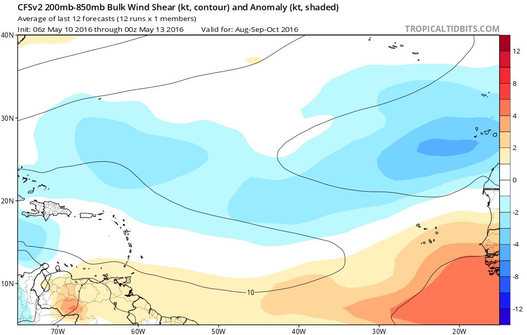
The majority of the Atlantic Basin is forecasted by the CFS to have below normal shear during the peak months of the hurricane season.

In fact just looking at June and July wind shear is expected to be well below normal across much of the usual development regions for those months.


SST Anomalies are looking quite warm across all of the Atlantic for the peak months.

Precipitation is looking iffy though for much of the Atlantic for the peak months.

MSLP looks to be on the higher than normal side for the peak months as well.

All in all one would assume by looking at these graphics that the Atlantic is probably in for an Average to maybe slightly Above Average season if the CFS is right. Of course things can and will change so stay tuned!
In fact just looking at June and July wind shear is expected to be well below normal across much of the usual development regions for those months.
SST Anomalies are looking quite warm across all of the Atlantic for the peak months.
Precipitation is looking iffy though for much of the Atlantic for the peak months.
MSLP looks to be on the higher than normal side for the peak months as well.
All in all one would assume by looking at these graphics that the Atlantic is probably in for an Average to maybe slightly Above Average season if the CFS is right. Of course things can and will change so stay tuned!
0 likes
-
TheStormExpert
Re: 2016 indicators: Instability / SST's / MSLP / Steering / Sal
cycloneye wrote:If the upper shear stays like this thru the peak of the season,it will be with tropical activity especially closer to the islands.
Add the Gulf of Mexico, East Coast, and maybe Caribbean to the list of decreasing shear values at the moment.


0 likes
-
Hurricaneman

- Category 5
- Posts: 7404
- Age: 45
- Joined: Tue Aug 31, 2004 3:24 pm
- Location: central florida
Re: 2016 indicators: Instability / SST's / MSLP / Steering / Sal
The shear levels coming down is a big worry this year and the warmer than normal Atlantic, Caribbean and GOM may this year be much more than many think, a couple of prime examples of warm EPAC MDR and Warm Atlantic are 2004 and 2005 and I wouldnt mind throwing 1985 in there either as its the closest analog to 2016 other than a cool MDR that year it most closely resembles that year
The posts in this forum are NOT official forecast and should not be used as such. They are just the opinion of the poster and may or may not be backed by sound meteorological data. They are NOT endorsed by any professional institution or storm2k.org. For official information, please refer to the NHC and NWS products
The posts in this forum are NOT official forecast and should not be used as such. They are just the opinion of the poster and may or may not be backed by sound meteorological data. They are NOT endorsed by any professional institution or storm2k.org. For official information, please refer to the NHC and NWS products
0 likes
-
cycloneye
- Admin
- Posts: 149408
- Age: 69
- Joined: Thu Oct 10, 2002 10:54 am
- Location: San Juan, Puerto Rico
Re: 2016 indicators: Instability / SST's / MSLP / Steering / Sal
ECMWF Precipitation forecast for ASO doesn't look with good moisture in MDR.

0 likes
Visit the Caribbean-Central America Weather Thread where you can find at first post web cams,radars
and observations from Caribbean basin members Click Here
and observations from Caribbean basin members Click Here
-
tarheelprogrammer
- S2K Supporter
- Posts: 1793
- Joined: Mon Mar 28, 2016 9:25 pm
- Location: Raleigh, NC area (Garner, NC)
Re: 2016 indicators: Instability / SST's / MSLP / Steering / Sal
cycloneye wrote:ECMWF Precipitation forecast for ASO doesn't look with good moisture in MDR.
How accurate has the model been in the past?
0 likes
My posts are not official forecasts. They are just my opinion and may or may not be backed by sound meteorological data. They are NOT endorsed by any professional institution or storm2k.org. For official information, please refer to the NHC and NWS products.
Re: 2016 indicators: Instability / SST's / MSLP / Steering / Sal
For JJA period, the latest Euro shows a not so dry forecast for the Caribbean than it did in its previous forecast last month.
Same thing for JAS & ASO. More l like near average over all than below average.


Compared to last year, the precipitation forecast is much wetter for ASO period compared to last year's forecast.


Same thing for JAS & ASO. More l like near average over all than below average.
Compared to last year, the precipitation forecast is much wetter for ASO period compared to last year's forecast.
0 likes


Re: 2016 indicators: Instability / SST's / MSLP / Steering / Sal
I made a rough approximation of the Caribbean (10-20N, 62-85W) and retrieved NCEP Reanalysis SST data for all years back to 1948; March 2016 was the warmest on record, while April 2016 was the 2nd warmest on record (for their respective months):
http://www.esrl.noaa.gov/psd/cgi-bin/da ... Timeseries
http://www.esrl.noaa.gov/psd/cgi-bin/da ... Timeseries
0 likes
-
wxman57

- Moderator-Pro Met

- Posts: 23173
- Age: 68
- Joined: Sat Jun 21, 2003 8:06 pm
- Location: Houston, TX (southwest)
Re: 2016 indicators: Instability / SST's / MSLP / Steering / Sal
SFLcane wrote:ECMWF Seasonal Model Atlantic Hurricane Forecast Update: Including Alex, now is predicting 13 Named Storms; 9 Hurricanes; 3 Major Hurricanes.
I'm looking at the paid ECMWF website and see 11.7 named storms with 7.5 hurricanes (not including Alex). ACE 90% of normal. I don't see anywhere that the ECMWF predicts a number of major hurricanes.
0 likes


Re: 2016 indicators: Instability / SST's / MSLP / Steering / Sal
Siker wrote:I made a rough approximation of the Caribbean (10-20N, 62-85W) and retrieved NCEP Reanalysis SST data for all years back to 1948; March 2016 was the warmest on record, while April 2016 was the 2nd warmest on record (for their respective months):
http://www.esrl.noaa.gov/psd/cgi-bin/da ... Timeseries
I am not the least bit surprised by this
0 likes

-
cycloneye
- Admin
- Posts: 149408
- Age: 69
- Joined: Thu Oct 10, 2002 10:54 am
- Location: San Juan, Puerto Rico
Re: 2016 indicators: Instability / SST's / MSLP / Steering / Sal
Very interesting almost 16 minute video by Levi Cowan about how he sees the 2016 Atlantic Hurricane Season shaping up.+PDO may be a big factor,Caribbean,GOM,Off East U.S coast the hot spots.
http://www.tropicaltidbits.com/blog/201 ... n-outlook/
http://www.tropicaltidbits.com/blog/201 ... n-outlook/
0 likes
Visit the Caribbean-Central America Weather Thread where you can find at first post web cams,radars
and observations from Caribbean basin members Click Here
and observations from Caribbean basin members Click Here
Who is online
Users browsing this forum: Europa non è lontana, mixedDanilo.E and 198 guests