Invest 96L=Tropical Wave in Southern Caribbean

This is the general tropical discussion area. Anyone can take their shot at predicting a storms path.

Moderator: S2k Moderators

Forum rules

The posts in this forum are NOT official forecasts and should not be used as such. They are just the opinion of the poster and may or may not be backed by sound meteorological data. They are NOT endorsed by any professional institution or STORM2K. For official information, please refer to products from the National Hurricane Center and National Weather Service.

Help Support Storm2K
Message
Author
Aric Dunn
Category 5
Category 5
Posts: 21238
Age: 42
Joined: Sun Sep 19, 2004 9:58 pm
Location: Ready for the Chase.
Contact:

Re: Invest 96L=Low/Tropical Wave East of Windwards

#401 Postby Aric Dunn » Fri Jul 06, 2007 5:59 am

Aric Dunn wrote:
punkyg wrote:
Opal storm wrote:This little thing is toast, sorry guys but climo is most likely going to win this battle.

Image

I'm not gonna give up until i see this thing dry up or ripped apart!


sounds goood.. its not dead .. yet moisture is on the incrase. slowly it still has a chance before the shears picks .. up and the shear may help it briefly.. with some lift and maybe yet advect some moisture in the mid and upper levels .. be fore the shear gets to strong..


that is what i wrote last evening...
0 likes   

User avatar
NDG
S2K Supporter
S2K Supporter
Posts: 15455
Joined: Sun Jul 09, 2006 10:14 pm
Location: Orlando, FL

Re: Invest 96L=Low/Tropical Wave East of Windwards

#402 Postby NDG » Fri Jul 06, 2007 6:33 am

I guess they made a type-error:

TROPICAL WEATHER DISCUSSION
NWS TPC/NATIONAL HURRICANE CENTER MIAMI FL
805 AM EDT FRI JUL 06 2007

A 1014 MB LOW PRES LOCATED NEAR 11N21W OR ABOUT 550 NM E OF
THE SOUTHERN WINDWARD ISLANDS IS MOVING W AT 10-15 KT. THIS WEAK
LOW CONTINUES TO HAVE MINIMAL TSTM ACTIVITY. THE LOW IS EMBEDDED
IN A TROPICAL WAVE LOCATED ALONG 15N51W TO 6N52W


http://www.nhc.noaa.gov/text/refresh/MIATWDAT+shtml/061039.shtml?

I guess the forecaster meant 11N/51W, but actually this morning I think the low is now near 53W, it has been moving fast the last 12 hrs.
0 likes   

User avatar
punkyg
Category 2
Category 2
Posts: 770
Joined: Mon Apr 23, 2007 7:37 pm
Location: sanford florida

#403 Postby punkyg » Fri Jul 06, 2007 6:57 am

Oh looky 96L has some convection to the northwest of the center.
0 likes   

User avatar
wzrgirl1
S2K Supporter
S2K Supporter
Posts: 1325
Joined: Sat Sep 04, 2004 6:44 am
Location: Pembroke Pines, Florida

Re: Invest 96L=Low/Tropical Wave East of Windwards

#404 Postby wzrgirl1 » Fri Jul 06, 2007 7:20 am

We need another storm to focus on and soon....this one is getting old. I may be sorry what I wish for huh?
0 likes   

User avatar
NDG
S2K Supporter
S2K Supporter
Posts: 15455
Joined: Sun Jul 09, 2006 10:14 pm
Location: Orlando, FL

Re: Invest 96L=Low/Tropical Wave East of Windwards

#405 Postby NDG » Fri Jul 06, 2007 7:44 am

There's just a trace of a circulation left this morning with 96L, it needs to do something today or else later on tonight or tomorrow morning would be nothing left of circulation to be found.

Image
0 likes   

User avatar
Trader Ron
S2K Supporter
S2K Supporter
Posts: 928
Joined: Tue Jul 22, 2003 7:25 pm
Location: Naples,Fl
Contact:

Re: Invest 96L=Low/Tropical Wave East of Windwards

#406 Postby Trader Ron » Fri Jul 06, 2007 8:00 am

In the end, 96L will die of a slow-death. I said it on July 3, and I'm sticking with my prediction.

:D :D
0 likes   

User avatar
skysummit
S2K Supporter
S2K Supporter
Posts: 5305
Age: 49
Joined: Tue Aug 31, 2004 11:09 pm
Location: Ponchatoula, LA
Contact:

Re: Invest 96L=Low/Tropical Wave East of Windwards

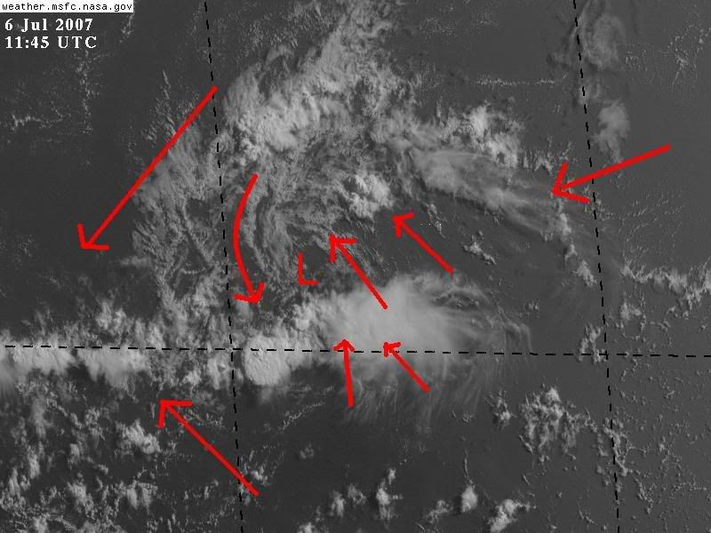
#407 Postby skysummit » Fri Jul 06, 2007 8:02 am

Look....there are two groups here. One that continues to monitor what's left of this Invest because there's SOMETHING STILL THERE. If it was completely dead, the dry air would've eaten it up 2 days ago....but no, there is still energy there, and still a circulation. Sure, it's going through a desert, and upper level winds are becoming increasingly unfavorable, but that even makes it more fun to watch. It has had a decent battle so far...can it continue? IF, that's a BIG IF, this makes it to the western Caribbean in tack some kind of way, it'll have to be watched. As you can tell, I'm in this group.

The other group is "it's dead", "stick a fork in 96L", and .....it doesn't pay to watch stray clouds crossing the Atlantic, or something like that. We get it. You don't believe anything will come out of this, and you're probably correct. If you do not wish to follow the progress of this invest, then simply don't respond. There are a couple other features our there for you to follow. Why wait until the season picks up to track anything? It IS hurricane season and has been so since June 1st. I, for one, as well as many others in here, really enjoy tracking the tropics. It doesn't have to be a Cat 3. A wave is nice...this is how you continue to build up on your tropical knowledge.
0 likes   

User avatar
cycloneye
Admin
Admin
Posts: 145888
Age: 69
Joined: Thu Oct 10, 2002 10:54 am
Location: San Juan, Puerto Rico

Re: Invest 96L=Low/Tropical Wave East of Windwards

#408 Postby cycloneye » Fri Jul 06, 2007 8:08 am

skysummit wrote:Look....there are two groups here. One that continues to monitor what's left of this Invest because there's SOMETHING STILL THERE. If it was completely dead, the dry air would've eaten it up 2 days ago....but no, there is still energy there, and still a circulation. Sure, it's going through a desert, and upper level winds are becoming increasingly unfavorable, but that even makes it more fun to watch. It has had a decent battle so far...can it continue? IF, that's a BIG IF, this makes it to the western Caribbean in tack some kind of way, it'll have to be watched. As you can tell, I'm in this group.

The other group is "it's dead", "stick a fork in 96L", and .....it doesn't pay to watch stray clouds crossing the Atlantic, or something like that. We get it. You don't believe anything will come out of this, and you're probably correct. If you do not wish to follow the progress of this invest, then simply don't respond. There are a couple other features our there for you to follow. Why wait until the season picks up to track anything? It IS hurricane season and has been so since June 1st. I, for one, as well as many others in here, really enjoy tracking the tropics. It doesn't have to be a Cat 3. A wave is nice...this is how you continue to build up on your tropical knowledge.


You are entierly correct.That is the reason to have storm2k and this Taking Tropics forum.In here we learn many things that you didn't know before about the tropics.You can voice different opinions about a system or other themes,of course without any namecalling etc.And also you make many friends who are enthusiastic tropical weather fans like you.But the most important thing is that you get the latest information in a rapid way,even before the media gets it. :)
0 likes   

User avatar
Trader Ron
S2K Supporter
S2K Supporter
Posts: 928
Joined: Tue Jul 22, 2003 7:25 pm
Location: Naples,Fl
Contact:

Re: Invest 96L=Low/Tropical Wave East of Windwards

#409 Postby Trader Ron » Fri Jul 06, 2007 8:16 am

skysummit wrote:Look....there are two groups here. One that continues to monitor what's left of this Invest because there's SOMETHING STILL THERE. If it was completely dead, the dry air would've eaten it up 2 days ago....but no, there is still energy there, and still a circulation. Sure, it's going through a desert, and upper level winds are becoming increasingly unfavorable, but that even makes it more fun to watch. It has had a decent battle so far...can it continue? IF, that's a BIG IF, this makes it to the western Caribbean in tack some kind of way, it'll have to be watched. As you can tell, I'm in this group.

The other group is "it's dead", "stick a fork in 96L", and .....it doesn't pay to watch stray clouds crossing the Atlantic, or something like that. We get it. You don't believe anything will come out of this, and you're probably correct. If you do not wish to follow the progress of this invest, then simply don't respond. There are a couple other features our there for you to follow. Why wait until the season picks up to track anything? It IS hurricane season and has been so since June 1st. I, for one, as well as many others in here, really enjoy tracking the tropics. It doesn't have to be a Cat 3. A wave is nice...this is how you continue to build up on your tropical knowledge.


Sky,

I don't need to be told by YOU, or anyone else, not to respond to a certain thread !I made a prediction with 96L. Case closed.
People were trying to make something out of 95L , when nothing was going to develop.
0 likes   

User avatar
Trader Ron
S2K Supporter
S2K Supporter
Posts: 928
Joined: Tue Jul 22, 2003 7:25 pm
Location: Naples,Fl
Contact:

#410 Postby Trader Ron » Fri Jul 06, 2007 8:21 am

One more thing. Don't tell me I'm not enthusiastic about the tropics! I've been following cyclones for over FIFTY years.

:D
0 likes   

User avatar
punkyg
Category 2
Category 2
Posts: 770
Joined: Mon Apr 23, 2007 7:37 pm
Location: sanford florida

#411 Postby punkyg » Fri Jul 06, 2007 8:30 am

0 likes   

User avatar
skysummit
S2K Supporter
S2K Supporter
Posts: 5305
Age: 49
Joined: Tue Aug 31, 2004 11:09 pm
Location: Ponchatoula, LA
Contact:

#412 Postby skysummit » Fri Jul 06, 2007 8:34 am

Well, I'm very happy for you and your fifty years of experience. However....how many times must it be said that 96 is dead? If you don't wish to follow it, and have no other constructive input than "it's dead", then there's no reason to respond. Everyone here knows it's likely dead, but some still do enjoy following it. With your fifty years, you should know that conditions can drastically change in 24 hours, and mother nature can do surprisingly weird things. I'm not saying that's going to happen here, but just implying this is the reason some here like to follow ALL aspects of the tropics. Like Luis said....this is a tropical forum and the whole reason why it's in operation.

....and by the way, did I say "Trader Ron, you're not enthusiastic about the tropics." No I didn't.
0 likes   

User avatar
tailgater
S2K Supporter
S2K Supporter
Posts: 3339
Joined: Sun Jul 11, 2004 9:13 pm
Location: St. Amant La.

Re: Invest 96L=Low/Tropical Wave East of Windwards

#413 Postby tailgater » Fri Jul 06, 2007 9:12 am

I'm not excited about 96L becoming a cane or anything but I don't see why it's being written off (by some) either. It's been in dry air 3 days now, small since it became an Invest with a lopsided circ. and inflow, now it's dealing with a little shear( which may help as someone stated earlier) and today it looks no better no worse than it did 2 days ago.IMHO
Still an Invest last time I checked.
0 likes   

User avatar
skysummit
S2K Supporter
S2K Supporter
Posts: 5305
Age: 49
Joined: Tue Aug 31, 2004 11:09 pm
Location: Ponchatoula, LA
Contact:

#414 Postby skysummit » Fri Jul 06, 2007 9:20 am

Thank you tailgater....still an Invest....nothing of concern, just something to watch :)
0 likes   

Chris_in_Tampa
Category 5
Category 5
Posts: 5077
Age: 42
Joined: Thu Jun 21, 2007 11:06 pm
Location: Tampa, Florida, USA
Contact:

#415 Postby Chris_in_Tampa » Fri Jul 06, 2007 9:28 am

ftp://ftp.tpc.ncep.noaa.gov/atcf/tcweb/ ... 007.invest
At 8AM EDT...
coordinates: 11.0N 54.1W
pressure: 1014mb

They finally posted the last two coordinates from 6 and 12Z. It doesn't have the "INVEST" title all the way to the right, but I think that happens when they don't have the other information. (Because it is weak, but I'm not 100% sure)

Found this link this morning about the ATCF system:
http://www.nrlmry.navy.mil/atcf_web/

"The Automated Tropical Cyclone Forecasting System (ATCF), developed by NRL Monterey, is a computer based application designed to automate and optimize the forecasting process at operational U.S. Department of Defense and National Weather Service tropical cyclone warning centers."

I didn't know they were the ones that actually developed it.

---

Wanted to add:

Visible: http://www.nrlmry.navy.mil/tcdat/tc07/A ... LATEST.jpg
IR: http://www.nrlmry.navy.mil/tcdat/tc07/A ... LATEST.jpg

Soon that imagery will recenter on the storm now that the ATCF database is updated.
Last edited by Chris_in_Tampa on Fri Jul 06, 2007 9:35 am, edited 1 time in total.
0 likes   

User avatar
SouthFloridawx
S2K Supporter
S2K Supporter
Posts: 8346
Age: 46
Joined: Tue Jul 26, 2005 1:16 am
Location: Sarasota, FL
Contact:

Re: Invest 96L=Low/Tropical Wave East of Windwards

#416 Postby SouthFloridawx » Fri Jul 06, 2007 9:30 am

Ya know, this wave may end up in a situation in the NW Caribbean where we could see it under Upper Level High Pressure. GFS Continually forms and area of ULH off of the SE Coast of the US, brings it over Florida and then moves in to the S. GOM and then to the NW Caribbean. I know that GFS is bad with upper level winds long range, but it something that it is continually showing.
http://www.nco.ncep.noaa.gov/pmb/nwprod/analysis/carib/gfs/06/index_250_lu_loop.shtml

GFS at the same time shows a short wave pushing down into the GL, Mid Atl and NE region of the US. We'll have to watch and see if something flares up from, this or even if it totally looses a circulation.
http://www.nco.ncep.noaa.gov/pmb/nwprod/analysis/carib/gfs/06/index_500_lu_loop.shtml

It looking at this, it could end up being a track something like this... and this is not an official forecast and I'm not saying it's definitely going to happen.

Image
0 likes   

User avatar
Tampa Bay Hurricane
Category 5
Category 5
Posts: 5597
Age: 37
Joined: Fri Jul 22, 2005 7:54 pm
Location: St. Petersburg, FL

Re:

#417 Postby Tampa Bay Hurricane » Fri Jul 06, 2007 9:57 am

skysummit wrote:Well, I'm very happy for you and your fifty years of experience. However....how many times must it be said that 96 is dead? If you don't wish to follow it, and have no other constructive input than "it's dead", then there's no reason to respond. Everyone here knows it's likely dead, but some still do enjoy following it. With your fifty years, you should know that conditions can drastically change in 24 hours, and mother nature can do surprisingly weird things. I'm not saying that's going to happen here, but just implying this is the reason some here like to follow ALL aspects of the tropics. Like Luis said....this is a tropical forum and the whole reason why it's in operation.

....and by the way, did I say "Trader Ron, you're not enthusiastic about the tropics." No I didn't.


Trader Ron and anyone has a right to state their opinion. Even if they think it's dead.
They are merely expressing their opinion. That's perfectly okay :wink:
0 likes   

User avatar
Tampa Bay Hurricane
Category 5
Category 5
Posts: 5597
Age: 37
Joined: Fri Jul 22, 2005 7:54 pm
Location: St. Petersburg, FL

Re: Invest 96L=Low/Tropical Wave East of Windwards

#418 Postby Tampa Bay Hurricane » Fri Jul 06, 2007 10:00 am

I do think this has a small chance for development
as it moves into the Caribbean. As of right now,
a small chance, but depending on the
conditions in the Caribbean that could change
in either direction.
0 likes   

User avatar
Chacor
Category 5
Category 5
Posts: 10229
Joined: Mon Oct 02, 2006 10:43 pm
Location: Singapore

#419 Postby Chacor » Fri Jul 06, 2007 10:14 am

THE AREA OF LOW PRESSURE LOCATED ABOUT 450 MILES EAST OF THE
SOUTHERN WINDWARD ISLANDS IS DEGENERATING INTO A TROPICAL WAVE.
ENVIRONMENTAL CONDITIONS ARE NOT FAVORABLE FOR DEVELOPMENT AS THIS
SYSTEM MOVES WESTWARD.
0 likes   

chadtm80

#420 Postby chadtm80 » Fri Jul 06, 2007 10:23 am

Alright everyone.. Lets just learn to discuss the tropics and ignore the posts that you don't wish to read. There is also a function here that you can use that will autimaticly "ignore" users you wish to and can be set up in your control panel. I don't personaly recommend using it as I want to read everyones posts. but the option is there if you wish to use it
0 likes   


Return to “Talkin' Tropics”

Who is online

Users browsing this forum: Cpv17, Lizzytiz1, redingtonbeach and 44 guests